
Hradešice
Hradešice | |
|---|---|
 View from the south | |
 Hradešice Location in the Czech Republic | |
| Coordinates: 49°19′24″N 13°35′47″E / 49.32333°N 13.59639°E | |
| Country | |
| Region | Plzeň |
| District | Klatovy |
| First mentioned | 1360 |
| Area | |
| • Total | 14.86 km2 (5.74 sq mi) |
| Elevation | 458 m (1,503 ft) |
| Population (2023-01-01)[1] | |
| • Total | 435 |
| • Density | 29/km2 (76/sq mi) |
| Time zone | UTC+1 (CET) |
| • Summer (DST) | UTC+2 (CEST) |
| Postal code | 341 01 |
| Website | www |
Hradešice is a municipality and village in Klatovy District in the Plzeň Region of the Czech Republic. It has about 400 inhabitants. The historic centre of the village is well preserved and is protected by law as a village monument zone.
Hradešice lies approximately 25 kilometres (16 mi) east of Klatovy, 50 km (31 mi) south of Plzeň, and 104 km (65 mi) south-west of Prague.
Administrative parts[edit]
The villages of Černíč and Smrkovec are administrative parts of Hradešice.
Demographics[edit]
| Year | Pop. | ±% |
|---|---|---|
| 1869 | 891 | — |
| 1880 | 951 | +6.7% |
| 1890 | 905 | −4.8% |
| 1900 | 866 | −4.3% |
| 1910 | 949 | +9.6% |
| 1921 | 931 | −1.9% |
| 1930 | 789 | −15.3% |
| 1950 | 655 | −17.0% |
| 1961 | 614 | −6.3% |
| 1970 | 561 | −8.6% |
| 1980 | 510 | −9.1% |
| 1991 | 457 | −10.4% |
| 2001 | 436 | −4.6% |
| 2011 | 404 | −7.3% |
| 2021 | 418 | +3.5% |
| Source: Censuses[2][3] | ||
Gallery[edit]
-
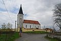 Church of the Transfiguration
 -
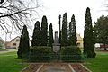 Monument to the victims of the world wars
 -
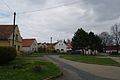 Centre of Hradešice


References[edit]
- ^ "Population of Municipalities – 1 January 2023". Czech Statistical Office. 2023-05-23.
- ^ "Historický lexikon obcí České republiky 1869–2011 – Okres Klatovy" (in Czech). Czech Statistical Office. 2015-12-21. pp. 11–12.
- ^ "Population Census 2021: Population by sex". Public Database. Czech Statistical Office. 2021-03-27.
External links[edit]
Wikimedia Commons has media related to Hradešice.
| Authority control databases: National |
|---|
This Plzeň Region location article is a stub. You can help Wikipedia by expanding it. |