
Hnačov
Hnačov | |
|---|---|
.jpg) Main road | |
 Hnačov Location in the Czech Republic | |
| Coordinates: 49°21′43″N 13°28′54″E / 49.36194°N 13.48167°E | |
| Country | |
| Region | Plzeň |
| District | Klatovy |
| First mentioned | 1411 |
| Area | |
| • Total | 3.15 km2 (1.22 sq mi) |
| Elevation | 565 m (1,854 ft) |
| Population (2023-01-01)[1] | |
| • Total | 90 |
| • Density | 29/km2 (74/sq mi) |
| Time zone | UTC+1 (CET) |
| • Summer (DST) | UTC+2 (CEST) |
| Postal code | 340 34 |
| Website | www |
Hnačov is a municipality and village in Klatovy District in the Plzeň Region of the Czech Republic. It has about 90 inhabitants.
Geography[edit]
Hnačov is located about 14 kilometres (9 mi) east of Klatovy and 41 km (25 mi) south of Plzeň. It lies in the Blatná Uplands. The highest point is the hill Zbudov at 645 m (2,116 ft) above sea level. The Úslava River flows through the municipality.
The village is situated on the shore of Hnačovský Pond, which is with an area of 68 km2 (26 sq mi) the second largest pond in the Plzeň Region. Established in 1613, it is used for fish farming and recreational purposes.[2]
History[edit]
The first written mention of Hnačov is from 1411.[2]
Demographics[edit]
|
|
| ||||||||||||||||||||||||||||||||||||||||||||||||||||||
| Source: Censuses[3][4] | ||||||||||||||||||||||||||||||||||||||||||||||||||||||||
Transport[edit]
There are no railways or major roads passing through the municipality.
Sights[edit]
There are no protected cultural monuments in the municipality.[5] A landmark is the chapel in the centre of Hnačov.
Gallery[edit]
-
 Crossroads
 -
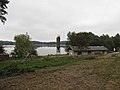 Hnačovský Pond
 -
 Bridge over the Úslava

.jpg)
.jpg)
References[edit]
- ^ "Population of Municipalities – 1 January 2023". Czech Statistical Office. 2023-05-23.
- ^ a b "O obci" (in Czech). Obec Hnačov. Retrieved 2023-03-22.
- ^ "Historický lexikon obcí České republiky 1869–2011 – Okres Klatovy" (in Czech). Czech Statistical Office. 2015-12-21. pp. 9–10.
- ^ "Population Census 2021: Population by sex". Public Database. Czech Statistical Office. 2021-03-27.
- ^ "Výsledky vyhledávání: Kulturní památky, okres Klatovy". Ústřední seznam kulturních památek (in Czech). National Heritage Institute. Retrieved 2023-07-06.
External links[edit]
| Authority control databases: National |
|---|