
Wikipedia:Graphics Lab/Map workshop/Archive/Nov 2023
| This page is an archive. Do not edit the contents of this page. Please direct any additional comments to the current main page. |
 | Archives of 2023: January, February, March, April, May, June, July, August, September, October, November, December |
Mexican wolf range map update
-
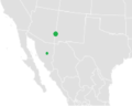 (Outdated) range map of the Mexican wolf, currently on the page

- Article(s)
- Mexican wolf
- Request
- Requesting a map that more accurately reflects the Mexican wolf's range as of 2023.
The current map on the Mexican wolf Wikipedia page shows only small points at the population centers.
However, an updated map should reflect that the wolves now range across a broad swath of western New Mexico and Eastern Arizona.
A reference map of the 2023 Mexican wolf range can be found here: https://img.federalregister.gov/EP17FE23.001/EP17FE23.001_original_size.png
This source is the US Federal Register, using data from the US Fish and Wildlife Service: https://www.federalregister.gov/documents/2023/02/17/2023-03196/endangered-and-threatened-wildlife-and-plants-establishment-of-a-nonessential-experimental
An additional reference map from the U.S. Fish and Wildlife Service shows the entire Mexican Wolf Recovery Area. This could also be included in the map to show where the wolves will likely expand in the coming years: https://www.fws.gov/media/mexican-wolf-experimental-pop-area-map
-- Bbreslau (talk) 19:53, 15 November 2023 (UTC)
- Discussion
@Bbreslau: I can help you, but first I need to know that you will be available here to support me with your knowledge and for proofreading etc? --always ping me-- Goran tek-en (talk) 12:20, 16 December 2023 (UTC)
- Hi, sure thing. I’m happy to proofread it. I appreciate your help! Bbreslau (talk) 12:25, 16 December 2023 (UTC)
 Request taken by --always ping me-- Goran tek-en (talk) 15:42, 16 December 2023 (UTC).
- @Bbreslau
- Which areas in this map?
- What do you want me to use in this map?
- --always ping me-- Goran tek-en (talk) 15:47, 16 December 2023 (UTC)
- From the first map, can you use the black section? It’s labeled on the key as “Current range of the Mexican wolf subspecies (Canis lupus baileyi)”.
- From this map, can you add the lines that represent the Wolf Management Zone Boundaries and the 2015 Mexican Wolf Experimental Population Area? These lines are shown in the key at the bottom left.
- Thank you Bbreslau (talk) 19:29, 16 December 2023 (UTC)
- @Bbreslau Please always ping me, thanks.
- You didn't tell me what to use in this link, I don't know which map or what? --always ping me-- Goran tek-en (talk) 11:59, 17 December 2023 (UTC)
- @Goran tek-en: I apologize for the confusion. There is nothing specific in this link that needs to be directly used in the map. I only included this link for literary reference, to scientifically validate the map. Bbreslau (talk) 12:04, 17 December 2023 (UTC)
- @Bbreslau Thanks, this is just to determine the overall area of the map, is this fine, otherwisw tell me which. --always ping me-- Goran tek-en (talk) 12:12, 17 December 2023 (UTC)
- @Goran tek-en Yes, this is perfect for the overall map area. Thank you, Bbreslau (talk) 12:15, 17 December 2023 (UTC)
- @Goran tek-en, I also forgot to clarify: In addition to the black area I requested in the first map, can you also keep the southern point that was used the original map (Canis_lupus_baileyi_range.png), referring to Mexico's population? As far as I know, this southern population is about the same as it was. Thank you, Bbreslau (talk) 12:19, 17 December 2023 (UTC)
- @Bbreslau Draft to be checked. --always ping me-- Goran tek-en (talk) 15:48, 17 December 2023 (UTC)
- @Goran tek-en The map looks great! A few requests:
- Can you remove the small part of the range that extends north of the 2015 population area boundary?
- Can you change the label of the blue boundary to "Wolf Management Zone 1"?
- Can you add and label the boundary for "Wolf Management Zone 2" as outlined in this map?
- Can you add "(Wolf Management Zone 3)" to the label "2015 Mexican Wolf Experimental Population Area"?
- Thank you again for doing this, Bbreslau (talk) 16:55, 17 December 2023 (UTC)
- @Bbreslau For 3., do you mean the dashed greenish area? --always ping me-- Goran tek-en (talk) 17:11, 17 December 2023 (UTC)
- @Goran tek-en for request number 3, I'm referring to the solid line that passes through the labels for highways 40, 93, 60/89,10, and 19 in the west, and through 81, 146, 10, 26, 25, 70, 54, 506, 24, and 285 in the east. This is labeled as "Wolf Management Zone 2" on the map. The same boundary is visible in this other map, outlining the blue area of Zone 2, if that helps for clarification.
- Thank you, Bbreslau (talk) 17:19, 17 December 2023 (UTC)
- @Bbreslau I'm not allowed to view that link.
- Draft 2, feedback. --always ping me-- Goran tek-en (talk) 13:05, 18 December 2023 (UTC)
- @Goran tek-en I approve! This is exactly what I was hoping for in the request. Thank you very much, Bbreslau (talk) 13:15, 18 December 2023 (UTC)
- @Bbreslau I will need the following;
- Name of the file
- Description (/language)
- Captions/s (/language)
- Category/ies at commons
- Structured data/Items portrayed in this file, the Q#, to be able to upload it at commons, thanks.
- --always ping me-- Goran tek-en (talk) 14:51, 18 December 2023 (UTC)
- @Goran tek-en Here is the information. This is my first time filling these categories out, so please let me know if there's anything missing or that should be edited.
- Name: Mexican gray wolf distribution 2023
- Description (/language): Mexican gray wolf distribution 2023 (/English)
- Captions/s (/language): Mexican gray wolf (Canis lupus baileyi) distribution in 2023. Boundaries indicate Wolf Management Zones designated by the US Fish and Wildlife Service.(/English)
- Categories at commons: Wolf distribution maps, Canis lupus baileyi
- Structured data/Items portrayed in this file: Canis lupus baileyi (Q531300), range (Q4257161)
- Thank you, Bbreslau (talk) 15:34, 18 December 2023 (UTC)
- @Bbreslau Now you can find it here Commons:File:Mexican gray wolf distribution 2023.svg.
- Please check all the information, also links for wikipedia, wikidata and structured data.
- If you are happy with this please put the code
{{re.solved|~~~~}}(without the ".") on this request so it can be archived, thanks. Done
Done
- --always ping me-- Goran tek-en (talk) 16:46, 18 December 2023 (UTC)
- @Goran tek-en This is great, thank you so much!!!
- {{resolved}}
- @Bbreslau Now you can find it here Commons:File:Mexican gray wolf distribution 2023.svg.
- @Goran tek-en Here is the information. This is my first time filling these categories out, so please let me know if there's anything missing or that should be edited.
- @Bbreslau I will need the following;
- @Goran tek-en I approve! This is exactly what I was hoping for in the request. Thank you very much, Bbreslau (talk) 13:15, 18 December 2023 (UTC)
- @Bbreslau For 3., do you mean the dashed greenish area? --always ping me-- Goran tek-en (talk) 17:11, 17 December 2023 (UTC)
- @Goran tek-en The map looks great! A few requests:
- @Bbreslau Draft to be checked. --always ping me-- Goran tek-en (talk) 15:48, 17 December 2023 (UTC)
- @Goran tek-en, I also forgot to clarify: In addition to the black area I requested in the first map, can you also keep the southern point that was used the original map (Canis_lupus_baileyi_range.png), referring to Mexico's population? As far as I know, this southern population is about the same as it was. Thank you, Bbreslau (talk) 12:19, 17 December 2023 (UTC)
- @Goran tek-en Yes, this is perfect for the overall map area. Thank you, Bbreslau (talk) 12:15, 17 December 2023 (UTC)
- @Bbreslau Thanks, this is just to determine the overall area of the map, is this fine, otherwisw tell me which. --always ping me-- Goran tek-en (talk) 12:12, 17 December 2023 (UTC)
- @Goran tek-en: I apologize for the confusion. There is nothing specific in this link that needs to be directly used in the map. I only included this link for literary reference, to scientifically validate the map. Bbreslau (talk) 12:04, 17 December 2023 (UTC)
- @Bbreslau
Range map for Pied cuckoo-dove
- Article(s)
- Pied cuckoo-dove
- Request
- Need a range map for this article, based on the IUCN range map available here. No preference colorwise, but ranges usually seem to be dark green on other range maps. -- AryKun (talk) 18:32, 11 November 2023 (UTC)
- Discussion
Iranian Azerbaijan location map
-
 Iranian Azerbaijan location map

- Articles
- Armenian Monastic Ensembles of Iran and articles for associated sites. Also applicable for articles related to sites in Iranian Azerbaijan in general.
- Request
- hello, i'd like to request a location map for Iranian Azerbaijan, based off of the Iran location map and similar to the Kurdistan Province Location Map, preferably with the bordering countries labeled for clarity. if anyone can help, it'd be much appreciated! thanks :)
- Discussion
Sawyer-mcdonell (talk) 18:16, 23 October 2023 (UTC)
- I've made a few Iranian location maps: I'm not sure if I have the time to but if someone wants to please email me to get the map data (it's very difficult to access from the NCC). – Isochrone (T) 13:03, 15 November 2023 (UTC)
- Done: Module:Location_map/data/Iran_Region_Azerbaijan and Done: File:Iran Region Azerbaijan location map.svg TheWanderingTraders (talk) 03:04, 27 December 2023 (UTC)
{{resolved}}
New range map for Alpine ibex

- Article(s)
- Request
A new range map for the species based on the IUCN Use only one color please. LittleJerry (talk) 00:59, 18 October 2023 (UTC)
Phoenician dependencies of Tyre and other locations map

- Article(s)
- Phoenician sanctuary of Kharayeb
- Request
- Based on the recommendation of Jengod here "Maybe a historical map showing the location of the temple near other cities of the era and/or the borders of the kingdom or empire?". I have explained on the Peer review page that it is very difficult with the current level of knowledge to determine the area of influence of Tyre in regards to neighboring Sidon, especially that the kingdoms are known to have merged at certain periods in history, therefore I will limit the request to the late Persian period. The best extant contemporaneous source we have is the Periplous of Pseudo-Scylax (text here), which enumerates the main cities on the Phoenician coast in 350BC, around the end of the Persian period. I would greatly appreciate your help in drafting a map of the Levantine coast, beginning with Sidon as the northernmost locality, and Sykaminon / Tell es-Samak, the farthest south. Please include the following sites with emphasis as specified below (include both names where indicated):
- Sidon (33.5639014,35.3702438)
- Ornithon / Tell el-Burak (
33.4909146,35.27725633.482388, 35.322636)
- ----------- Demarcation line ----------
- Sarepta (33.464325,35.295235)
- Jemjim (
33.3900019,35.278762) [Please replace with more accurate (33.360345, 35.276024) el.ziade (talkallam) 10:00, 28 December 2023 (UTC)] - Kharayeb sanctuary (33.345900,35.281500)
- Tyre (33.2712962,35.1933497) Please copy the outline of Tyre from the sources I will provide. It has to show as an island as it was not yet connected to the mainland (Alexander did that by destroying mainland Tyre (paleotyrus) and filling the sea.
- Paleotyrus / Ushu (33.2671084,35.2163915)
- Umm al-Amad (33.128000,35.153500)
- Achzib (
33.0820452,35.10923933.048317, 35.102346) - Acre (
33.0121642,35.18750532.9215034,35.0877983) - Sykaminon / Tell es-Samak (32.824937,34.955257)
- Please also add two colored overlays, with two colors for the spheres of influence of Tyre and Sidon. Tyre in this color (#990024) and Sidon with this one (#4B0082). The overlays would start at an opacity of 100% at the shoreline and gradually decrease to disappear 15km into the mainland and parallel to the shoreline (gradient overlay to denote fading influence the more inland one goes as we know that Itureans and other Semitic tribes occupied the hinterland, particularly in the south). The demarcation line between the two areas of influence is the area between Tell el-Burak and Sarepta.
- The title of the map would be Tyre and its dependencies according to pseudo-Scylax around
335350BC, including the Kharayeb sanctuary. - This is a link showing how Tyre looked as an island around that time before the sea was filled up by Alexander on page 1293, inset 5. Tell Mashuk (Maachouq on google maps) is where Ushu would have stood before it was flattened by Alexander.
- Reference
- Elayi, Josette (1988). "Studies in Phoenician Geography during the Persian Period". Journal of Near Eastern Studies. 41 (2). University of Chicago Press: 83–110 – via JSTOR.
- Periplos of Pseudo-Scylax]
- Marriner, Nick; Morhange, Christophe; Carayon, Nicolas (2008). "Ancient Tyre and its harbours: 5000 years of human-environment interactions". Journal of Archaeological Science. 35 (5): 1281. ISSN 0305-4403.
- Oggiano, Ida (2013). Aliquot, Julien; Bonnet, Corinne (eds.). "Le sanctuaire de Kharayeb et l'évolution de l'imagerie phénicienne dans l'arrière-pays de Tyr". Topoi (Supplément 13 La Phénicie hellénistique - Actes du colloque international de Toulouse): 240–266.
- Discussion
This is a well written request from a graphic workers point of view, but it's not signed.
Is it @Elias Ziade: who has created it?
I can help here but I need to be in contact with the requester throughout the whole process so get back to me if it's you, thanks. --always ping me-- Goran tek-en (talk) 12:33, 16 December 2023 (UTC)
- @Goran tek-en Hey! Sorry for the oversight. It was me indeed. Thanks a lot for your help. el.ziade (talkallam) 12:38, 17 December 2023 (UTC)
- Request taken by --always ping me-- Goran tek-en (talk) 16:05, 17 December 2023 (UTC).
- @Elias Ziade Just remember I have zero knowledge of this topic.
- First we have to get the overall area of the map, is this area fine?
- The link for Tyre in the pdf is behind a log in so please provide me with a good screen print or other?
- Is there not copyright on that pdf? For me it's a big difference because it means if I can copy or just use it as information.
- --always ping me-- Goran tek-en (talk) 16:35, 17 December 2023 (UTC)
- @Goran tek-en I will check and get back to you. el.ziade (talkallam) 14:57, 18 December 2023 (UTC)
- @Goran tek-en I think all rights are reserved by Elsevier for that one. There are a few ones on Commons that will do the trick. Tyre will likely look like a dot facing the shoreline anyway. el.ziade (talkallam) 15:46, 18 December 2023 (UTC)
- @Elias Ziade Thanks, you didn't respond to my question regarding the overall area of the map. --always ping me-- Goran tek-en (talk) 16:48, 18 December 2023 (UTC)
- @Goran tek-en Yes, the area is perfect. In response to your concern regarding your lack of familiarity with the subject, I intend to engage several users for a review upon completion of an initial draft of the map. el.ziade (talkallam) 09:25, 19 December 2023 (UTC)
- @Elias Ziade
- ----
- Those drafts are PNG versions of the original SVG file I'm working in and will upload to commons.
- Those drafts are shown for proofreading only.
- ----
- You specially have to check "Ornithon / Tell el-Burak" as the coordinates end up in the ocean.
- I wasn't sure if the ciry marker for Tyre should be on the island or where I put it now.
- Check everything on this draft-1. Feedback thanks.
- --always ping me-- Goran tek-en (talk) 16:14, 21 December 2023 (UTC)
- @Goran tek-en Thanks a lot for the map. These are the coordinates for Ornithon / Tell el-Burak (33.482388, 35.322636) and the marker for the city of Tyre should be indeed the island. @Onceinawhile can you help fact check the map and who else do you believe can help with this?
- el.ziade (talkallam) 09:36, 28 December 2023 (UTC)
- @Goran tek-en I have made adjustments to the coordinates. Happy holidays! el.ziade (talkallam) 10:01, 28 December 2023 (UTC)
- @Elias Ziade Draft-2 to be checked, thanks. --always ping me-- Goran tek-en (talk) 10:56, 28 December 2023 (UTC)
- This article The Phoenician Cities in the Persian Period may help. It says:
We have basically two valuable Greek sources dating from the Persian period: the Histories of Herodotus and the Periplus of Pseudo-Scylax... As far as we know, there were six Phoenician cities in the Persian period: Sidon, Tyre, Arados, Byblos, Tripoli, and Berytos... In the Phoenician cities, whichever Phoenician community was most powerful imposed its rule. Some towns, however, could belong to the territory of a Phoenician city even though the Phoenician community was a minority, for example, Ashkelon, a Philistine town which belonged to Tyre in the Persian period according to Pseudo-Scylax... Phoenicia was not, of course, a country in the modern sense of the word. Yet, it is often more convenient to say "Phoenicia" instead of "Phoenician cities," just as there is a convention to use the word"Greece" to designate the Greek cities... Phoenician cities could be discontinuous. We know from the Periplus, for example, that, beyond the town of Dor, which was controlled by the Sidonians, there were southwards the towns of Crocodeilon and Ashkelon belonging to the Tyrians. The fact that these last two towns were separated from the territory of Tyre did not much matter because the Phoenician coastal plain itself was fragmented by nature (note, for example, that the promontory of Theouprosopon completely interrupts coastal communications); and because the Phoenicians could easily communicate by sea.
- I can't see the draft map because I don't have access to google via my wiki account, but it will be important that it illustrates the fragmented / discontinuous nature of the Tyrian domain. Onceinawhile (talk) 17:51, 28 December 2023 (UTC)
- @Onceinawhile The draft is just as any link to use in any web browser, should not be a problem for anyone. --always ping me-- Goran tek-en (talk) 14:04, 29 December 2023 (UTC)

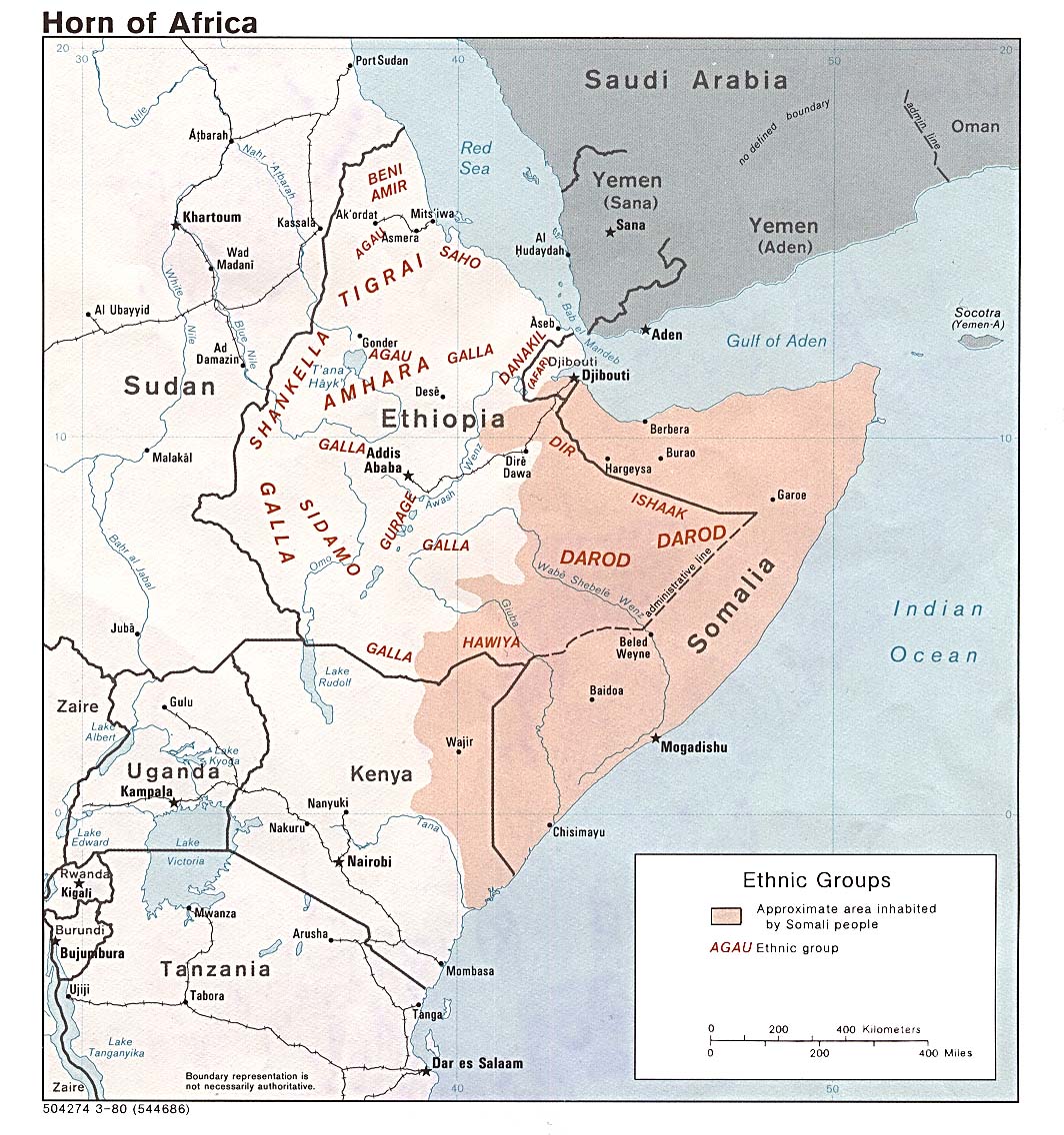
Pseudo-Scylax manuscript pages describing the coast of Syria and Phoenicia (annotated) - Thank you Goran, the link is working now. I have done some more work on the Scylax sources - reviewing the original manuscript (see to the right) - and the secondary sources which interpret Scylax, two of which include maps.
- Galling, Kurt (1938). "Die syrisch-palästinische Küste nach der Beschreibung bei Pseudo-Skylax". Zeitschrift des Deutschen Palästina-Vereins (1878-1945). 61 (1/2). Deutscher Verein zur Erforschung Palästinas: 66–96. ISSN 2192-3124. JSTOR 27930190.
- Elayi, Josette (1982). "Studies in Phoenician Geography during the Persian Period". Journal of Near Eastern Studies. 41 (2). University of Chicago Press: 83–110. ISSN 0022-2968. JSTOR 544660.
- Lipiński, E. (2004). Itineraria Phoenicia. Orientalia Lovaniensia analecta. Uitgeverij Peeters en Departement Oosterse Studies. p. 273. ISBN 978-90-429-1344-8. <= See map here
- Shipley, G. (2011). Pseudo-Skylax's Periplous: The Circumnavigation of the Inhabited World : Text, Translation and Commentary. Liverpool University Press Series. Bristol Phoenix Press. p. 180. ISBN 978-1-904675-82-2.<= See map here
- What is clear is that the manuscript is mutilated, and this is the only known one to have survived. So scholars have made quite a few assumptions - a number of the cities in the original link Elie provided above are not mentioned in Scylax, and are simply assumed.
- If you are happy to, it would be very valuable to also have a pure representation of Scylax's description of the full coastline, perhaps following Lipinski's and Shipley's versions above, which cover a wider area. Lipinski's and Shipley's interpretations of Scylax differ in a number of ways, and it would be valuable to show those differences. https://we.tl/t-xVOQO1XPpT Here is a temporary link to a relevant file
- As for the narrow area covered in Goran's map, the only amendments all this research has uncovered are that Sidonian influence begins again at the south of the map:
- (1) Atlit (32°42′19″N 34°56′02″E), which Shipley believes is meant by the second Arados, is a Sidonian city
- (2) Tel Dor (32°37′03″N 34°55′03″E) is also a Sidonian city
- This should be demarcated, as the current map implies that Tyrian influence continues onwards.
- Onceinawhile (talk) 17:08, 29 December 2023 (UTC)
- @Onceinawhile I have indeed included the sites pertinent to the Kharayeb Sanctuary article. I recognize the importance of constructing a map of Phoenicia based on the description by Pseudo-Scyllax, devoid of modern additions. Creating such a map would serve as a valuable tool for visualizing the periplos.
- Looking ahead, I suggest focusing solely on incorporating sites listed in the periplos. This would align with the objective of accurately representing the geographical details outlined by Pseudo-Scyllax.
- To distinguish between Tyrian and Sidonian dependencies on the map, we could employ a distinct marking or color scheme for each, ensuring clarity in visualizing the respective territories. What do you think? What do you suggest we do with Byblos? Shall we add a third color key indicating known Phoenician cities not listed in the Periplos? el.ziade (talkallam) 13:17, 3 January 2024 (UTC)
- Hi Elie, that all makes sense to me. Onceinawhile (talk) 13:25, 3 January 2024 (UTC)
- @Elias Ziade @Onceinawhile I have to be clear about that all you are writing above is for me a discussion which I'm not involved in (this is maybe not the best place for that).
- When you are done with that, you specifically have to ping me and tell me what to edit in short and exact text, thanks. --always ping me-- Goran tek-en (talk) 12:07, 4 January 2024 (UTC)
- @Elias Ziade@Onceinawhile So I need to understand what is going on...
- Can we continue on this or is it a {{stale}}
- seriously, tell me what's going on, thanks. --always ping me-- Goran tek-en (talk) 13:31, 11 January 2024 (UTC)
- Hi Elie, that all makes sense to me. Onceinawhile (talk) 13:25, 3 January 2024 (UTC)
- @Onceinawhile The draft is just as any link to use in any web browser, should not be a problem for anyone. --always ping me-- Goran tek-en (talk) 14:04, 29 December 2023 (UTC)
- This article The Phoenician Cities in the Persian Period may help. It says:
- @Elias Ziade Draft-2 to be checked, thanks. --always ping me-- Goran tek-en (talk) 10:56, 28 December 2023 (UTC)
- @Goran tek-en Yes, the area is perfect. In response to your concern regarding your lack of familiarity with the subject, I intend to engage several users for a review upon completion of an initial draft of the map. el.ziade (talkallam) 09:25, 19 December 2023 (UTC)
- @Elias Ziade Thanks, you didn't respond to my question regarding the overall area of the map. --always ping me-- Goran tek-en (talk) 16:48, 18 December 2023 (UTC)
- @Goran tek-en I think all rights are reserved by Elsevier for that one. There are a few ones on Commons that will do the trick. Tyre will likely look like a dot facing the shoreline anyway. el.ziade (talkallam) 15:46, 18 December 2023 (UTC)
- @Goran tek-en I will check and get back to you. el.ziade (talkallam) 14:57, 18 December 2023 (UTC)
- @Elias Ziade Just remember I have zero knowledge of this topic.
.png)
SVG locator map of Greater Somalia in the gray and green globe scheme
-
 The map should be based off of this map created by the CIA.
 -
 Finished map

.svg)
- Article(s)
- Greater Somalia
- Request
- Create an SVG locator map of Greater Somalia in the gray and green globe scheme. The map should be based off of this map (shown above) created by the CIA. -- Treetoes023 (talk) 01:58, 7 January 2024 (UTC)
- Discussion
- Since it appears that some editors have been fiddling with original map, I looked for it and found it here (mentioned in this source). Would basing the map on the original source work for you? M.Bitton (talk) 18:24, 10 January 2024 (UTC)
- @M.Bitton: Yes, it would actually be ideal to use the unaltered map. – Treetoes023 (talk) 22:09, 10 January 2024 (UTC)
- Request taken by M.Bitton (talk) 23:53, 10 January 2024 (UTC).
- Done M.Bitton (talk) 18:35, 11 January 2024 (UTC)
- @M.Bitton: Can you change the green island in Kenya to gray because it is not a part of Greater Somalia? Also, could you tint the borders that overlap with Greater Somalia green (like this map does). – Treetoes023 (talk) 19:50, 11 January 2024 (UTC)
- @M.Bitton: Yes, it would actually be ideal to use the unaltered map. – Treetoes023 (talk) 22:09, 10 January 2024 (UTC)
.svg)
{{resolved}}