
Wikipedia:Graphics Lab/Map workshop/Archive/Jun 2023
| This page is an archive. Do not edit the contents of this page. Please direct any additional comments to the current main page. |
 | Archives of 2023: January, February, March, April, May, June, July, August, September, October, November, December |
Extract geodata
Again a data extraction request I do not know how to do it: There is File:Map of Upper Abkhazia.svg, and I am looking for the boundary of this area as a shapefile. Could anyone here extract that?--Antemister (talk) 09:05, 22 July 2023 (UTC)
- @Antemister: There isn't an easy way to turn an SVG into a shapefile. Giorgi Balakhadze might be willing to disclose the data source they used to generate the map. If that fails, you should be able to generate the sub-watersheds from a DEM and trace the parts you are interested in. -- Guerillero Parlez Moi 09:33, 22 July 2023 (UTC)
- Not sufficiently skilled in GIS, that's why I have asked, hoped that the SVG still contains the original coordinates. Will ask Giorgi Balakhadze.--Antemister (talk) 10:50, 22 July 2023 (UTC)
- Have gotten the data{{resolved}}
- Not sufficiently skilled in GIS, that's why I have asked, hoped that the SVG still contains the original coordinates. Will ask Giorgi Balakhadze.--Antemister (talk) 10:50, 22 July 2023 (UTC)
Flag map of Zimbabwe Rhodesia
{{resolved}}
-
 Flag of Zimbabwe Rhodesia (1979)
 -
 Flag map of Zimbabwe (1980–present)
 -
 Flag map of Rhodesia (1968–1979)
 -
 Flag map of Rhodesia (1964–1968)
 -
 Flag map of Southern Rhodesia (1924–1953, 1963–1964)
.svg)

.svg)
.svg)
.svg)
- Article(s)
- Anywhere where a flag map would be relevant.
- Request
- Could someone please create an SVG flag map for the short-lived state of Zimbabwe Rhodesia, using the flag provided above. I've also provided the already-existing SVG flag maps representing the other Zimbabwean/Rhodesian regimes from throughout the years, to give an idea as to how it should be done. Thanks. Snow Lion Fenian (talk) 13:36, 6 July 2023 (UTC)
- Discussion
- @Snow Lion Fenian done, please see File:Flag map of Zimbabwe Rhodesia (1979).svg. Unfortunately, due to the nature of the flag, I was unable to fit the entirety of the symbol in. – Isochrone (T) 10:07, 24 July 2023 (UTC)
- @Isochrone: Thats perfectly okay, and thanks again for helping out! I do appreciate it greatly. Snow Lion Fenian (talk) 17:14, 24 July 2023 (UTC)
Edit Arctic Circle orthographic projection map
-
 Map that needs editing.
 -
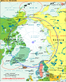 Reference map of the Arctic Circle if needed.
.svg)

- Article(s)
- Arctic
- Arctic Circle
- Request
- Change the color of the land in the Arctic Circle to and change the color of the water in the Arctic Circle to . -- Treetoes023 (talk) 18:13, 13 July 2023 (UTC)
- Discussion
- @Treetoes023
 Done with File:Arctic (orthographic projection with highlights).svg – Isochrone (T) 14:24, 23 July 2023 (UTC)
- @Isochrone: Thanks! – Treetoes023 (talk) 16:02, 24 July 2023 (UTC)
{{resolved}}
Locator map of geographic Siberia in the gray and green globe scheme
-
 Map of the Ural Mountains
 -
 Finished map

.svg)
- Article(s)
- Siberia
- North Asia
- Request
- The current map of Siberia/North Asia uses the Ural Federal District as the western border of Siberia, can someone make a map where the western border is the Ural Mountains instead (the Ural Mountains is the geographic western border of Siberia, not the western border of the Ural Federal District, although they are similar)? Also, the current map is centered on Russia and not Siberia, so could this map be centered on Siberia instead of Russia? -- Treetoes023 (talk) 18:04, 20 July 2023 (UTC)
- Discussion
- @M.Bitton: Could you do this request? As always, it's okay if you don't want to or can't, I know you are busy and you are under no obligation to do this request. – Treetoes023 (talk) 18:08, 20 July 2023 (UTC)
- @Treetoes023: tbh, the time that I tend to allocate to making maps has been eaten up by some disruptive editing that I have been dealing with. I didn't even start the request that I took and don't plan on taking another until things calm down a little. I'll let you know if the situation changes. M.Bitton (talk) 18:33, 20 July 2023 (UTC)
- @M.Bitton: That's okay, no worries! Good luck with dealing with the disruptive editing. – Treetoes023 (talk) 18:39, 20 July 2023 (UTC)
- @Treetoes023: tbh, the time that I tend to allocate to making maps has been eaten up by some disruptive editing that I have been dealing with. I didn't even start the request that I took and don't plan on taking another until things calm down a little. I'll let you know if the situation changes. M.Bitton (talk) 18:33, 20 July 2023 (UTC)
 Request taken by M.Bitton (talk) 18:29, 24 July 2023 (UTC).
- Done M.Bitton (talk) 20:35, 24 July 2023 (UTC)
- @M.Bitton: Thanks, amazing as always. – Treetoes023 (talk) 20:44, 24 July 2023 (UTC)
{{resolved}}
Update Welsh language map
-
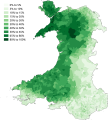 Map of the percentage of people aged three years or older able to speak Welsh by Lower Super Output Area (LSOA) using statistics from the 2011 Welsh census.
 -
 Done
Done


- Article(s)
- Welsh language
- Request
- This map (made by the now inactive user SkateTier) is a map of the percentage of people aged three years or older able to speak Welsh by Lower Super Output Area (LSOA) using statistics from the 2011 Welsh census, can someone make a map of the percentage of people aged three years or older able to speak Welsh by Lower Super Output Area (LSOA) using statistics from the 2021 Welsh census? The Welsh Government made its own map, but it only divides the LSOAs into 5 categories, opposed to the 10 categories that SkateTier's map divides the LSOAs into. When making the map, stick to the 10 categories present in SkateTier's map, instead of the 5 categories in the Welsh Government's map. Also use the same colors as SkateTier's map. If it helps, SkateTier's map was made using QGIS. -- Treetoes023 (talk) 03:11, 27 July 2023 (UTC)
- Discussion
- Request taken. – Isochrone (T) 09:41, 27 July 2023 (UTC)
- @Treetoes023 Done with File:Welsh speakers in the 2021 census.svg – Isochrone (T) 10:06, 27 July 2023 (UTC)
- @Isochrone: Looks great, thank you! – Treetoes023 (talk) 18:35, 27 July 2023 (UTC)
- @Treetoes023
{{resolved}}
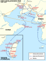
Indiana Jones locations map
{{resolved}} (this request is also present in the Commons:Graphic Lab/Map workshop)

- Article(s)
- Indiana Jones
- Request
- Could someone please modify the above map showing the countries visited throughout the Indiana Jones film franchise, to include those in which on-screen events occur during The Dial of Destiny film. Having seen the film recently, I can confirm that the relevant countries are: France, the United States, the United Kingdom, Morocco, Greece and Italy.
- I'd recommend using the same shade of purple in which the United States is already shaded to represent the new set of countries. And I'd also recommend using a diagonal stripe pattern for countries seen in more than one film (similar to Peru). Which means the United States should be re-shaded in red-blue-yellow-purple stripes, and Italy should be re-shaded in blue and purple stripes. Thanks. Snow Lion Fenian (talk) 13:15, 25 July 2023 (UTC)
- Discussion
- Request taken by M.Bitton (talk) 23:16, 27 July 2023 (UTC).
- @Snow Lion Fenian: Done M.Bitton (talk) 11:23, 28 July 2023 (UTC)
- @M.Bitton: That's great, and thank you for your time and help. Snow Lion Fenian (talk) 20:06, 28 July 2023 (UTC)
- @M.Bitton: Actually, now that it's come to my attention, is there any chance you could change Austria back to blue, and Switzerland back to grey? Sorry about this. Snow Lion Fenian (talk) 21:20, 28 July 2023 (UTC)
- @M.Bitton: Thanks again! Snow Lion Fenian (talk) 22:21, 28 July 2023 (UTC)
- @M.Bitton: That's great, and thank you for your time and help. Snow Lion Fenian (talk) 20:06, 28 July 2023 (UTC)
Bancroft, Ontario, Canada, map of geological locations
-
 Map uranium mines around Bancroft
 -
 Finished map


- Article(s)
- Uranium mining in the Bancroft area
- Request
- Could this map be redone please? Requesting addition of colour, hopefully allowing it to be used at a smaller size. (This is as requested by a reviewer while the article is being reviewed on the path to Featured Article status (link for more context) -- CT55555(talk) 12:04, 9 July 2023 (UTC)
- Discussion
 Bumping thread. I might be able to work on this but depends if I get the time. – Isochrone (T) 11:52, 22 July 2023 (UTC)
- Request taken. – Isochrone (T) 17:14, 23 July 2023 (UTC)
- @CT55555 hi @CT55555, so I've done your request but there are some stupid SVG bugs that are being really irksome, the file is here but it doesn't display correctly until you click on the thumbnail to load the SVG in your browser. I've asked for some help on the relevant forum and if it doesn't work I may just say the file as a PDF (hopefully not).In the meantime, feel free to suggest any changes as appropriate. I have intentionally neglected a key as it would make more sense in the caption. The relevant wikitext is below. I also made a shaded relief background, as I thought the geology was relevant, but I'm happy to remove it.Granite, granitic gneissParagneiss para-amphiboliteMarbleSyenite, syenitic and hybrid gneissMetagabbro– Isochrone (T) 20:34, 23 July 2023 (UTC)
- @CT55555, Done File:Bancroft uranium mining map.svg fixed and ready for use, feel free to suggest changes as appropriate. – Isochrone (T) 09:32, 24 July 2023 (UTC)
- @CT55555,
- @CT55555 hi @CT55555, so I've done your request but there are some stupid SVG bugs that are being really irksome, the file is here but it doesn't display correctly until you click on the thumbnail to load the SVG in your browser. I've asked for some help on the relevant forum and if it doesn't work I may just say the file as a PDF (hopefully not).In the meantime, feel free to suggest any changes as appropriate. I have intentionally neglected a key as it would make more sense in the caption. The relevant wikitext is below. I also made a shaded relief background, as I thought the geology was relevant, but I'm happy to remove it.
Tour de France Femmes 2023
{{resolved}}
-
 Finished map

- Article(s)
- 2023 Tour de France Femmes
- Request
- Hi, I'm looking for someone to do a free version of the 2023 Tour de France Femmes map - the official one is here. As with last year, I asked Andrei loas who has previously done excellent maps (e.g. this for the 2022 men's race) if he could create one, but he hasn't got back to me unfortunately.
This is last years map, by the excellent M.Bitton.

Turini2 (talk) 21:13, 10 July 2023 (UTC)
- Discussion
- Request taken by M.Bitton (talk) 12:44, 14 July 2023 (UTC).
- @Turini2: Done Please double-check everything and let me know if I missed something. M.Bitton (talk) 10:37, 23 July 2023 (UTC)
SVG locator map of European Russia in the gray and green globe scheme
-
Map of the Ural Mountains.
-
 Finished map
.svg)
- Article(s)
- European Russia
- Request
- Create an SVG locator map of European Russia in the gray and green globe scheme. The boundary between Europe and Asia is the Ural Mountains. -- Treetoes023 (talk) 22:13, 25 July 2023 (UTC)
- Discussion
- @M.Bitton: Could you do this request? As always, it's okay if you don't want to or can't, I know you are busy and you are under no obligation to do this request. – Treetoes023 (talk) 22:17, 25 July 2023 (UTC)
- Request taken by M.Bitton (talk) 23:17, 27 July 2023 (UTC).
- @M.Bitton: I just found out some stuff about the border between Russia and Asia that you should know for the map.
- The boundaries between Europe and Asia that I am using are the ones provided in the first paragraph of the lede of the Europe article (I added a link directly to the text I am referring to so it is easier for you to find). I hope this helps. – Treetoes023 (talk) 05:57, 28 July 2023 (UTC)
- We already had a similar conversation about loosely defined concepts. If you recall, I said that I tend to choose one and stick to it, which in this instance would make European Russia equal to "Russia" minus "Siberia" (the previous map whose borders were defined by the Ural Mountains and not the river). M.Bitton (talk) 10:29, 28 July 2023 (UTC)
- @Treetoes023: I screwed up the ping. M.Bitton (talk) 10:30, 28 July 2023 (UTC)
- @M.Bitton: Oh okay. – Treetoes023 (talk) 02:08, 29 July 2023 (UTC)
- Done M.Bitton (talk) 11:33, 29 July 2023 (UTC)
- @M.Bitton: Thank you, it looks great! – Treetoes023 (talk) 19:12, 29 July 2023 (UTC)
- @M.Bitton: Oh okay. – Treetoes023 (talk) 02:08, 29 July 2023 (UTC)
{{resolved}}
Replace font in map
-
 Map in question

- Article(s)
- History of East Asia
- Korea under Japanese rule
- and many more
- Request
- Simple font replacement. It's a great map, but the font feels like a Wonton font. The orig creator's other maps of East Asia (notably Japan) use similar fonts, but their maps for elsewhere do not. I think they had good intentions, but a more neutral font would raise fewer eyebrows. -- toobigtokale (talk) 00:35, 27 July 2023 (UTC)
- Discussion
- Request taken. – Isochrone (T) 09:04, 29 July 2023 (UTC)
- @Toobigtokale Done, the svg was horrible and I managed to shrink it 20 times, and I updated the font to a nice, editable one that can be easily translated. Feel free to suggest corrections as appropriate. – Isochrone (T) 09:10, 29 July 2023 (UTC)
- Thanks, it looks great :) toobigtokale (talk) 16:22, 29 July 2023 (UTC)
- @Toobigtokale
Swamps in Belarus in png
-
 original maps
 -
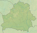 can be used as base?


- Article(s)
- Swamps in Belarus (new article)
- Request
- I'd like to get a png map of swamps in Belarus. Please leave only the year under each map, and use English for city names. Thanks! Artem.G (talk) 05:49, 27 June 2023 (UTC)
- Discussion
Singapore whiskered bat range map
{{resolved}}

.svg)
.svg)
.svg)
- Article(s)
- Singapore whiskered bat
- Request
- Please create a range map based on the data described at the IUCN Redlist entry. -- UtherSRG (talk) 22:50, 10 July 2023 (UTC)
- Discussion
- Not sure if {{maplink}} works with speciesbox, but considering the small scale, it would be best for this. – Isochrone (T) 10:13, 24 July 2023 (UTC)
- @UtherSRG Done with a dynamic map. – Isochrone (T) 20:42, 27 July 2023 (UTC)
- Hrm.. I get a broken link when looking at the article, but when I click the map it takes me to it. - UtherSRG (talk) 10:30, 28 July 2023 (UTC)
- Great, maplink is deciding to be stupid again. It should fix itself in a bit. – Isochrone (T) 13:07, 28 July 2023 (UTC)
- Hrm.. I get a broken link when looking at the article, but when I click the map it takes me to it. - UtherSRG (talk) 10:30, 28 July 2023 (UTC)
- @UtherSRG
Locator map of the Balkans in the gray and green globe scheme
- Article(s)
- Balkans
- Request
- Create a locator map of the Balkans in the gray and green globe scheme. -- Treetoes023 (talk) 23:07, 10 July 2023 (UTC)
- Discussion
- The one problem with making a locator map for the Balkans is that it has very many geographical and political definitions. If a map were made, it would have constant disputes on its talk page over such definitions. — Mugtheboss (talk) 22:31, 12 August 2023 (UTC)
- That and the fact that I couldn't proper RS maps that show the region in a consistent manner were the main reasons why I didn't take the request. M.Bitton (talk) 22:34, 12 August 2023 (UTC)
- Oh okay. – Treetoes023 (talk) 23:33, 12 August 2023 (UTC)
- That and the fact that I couldn't proper RS maps that show the region in a consistent manner were the main reasons why I didn't take the request. M.Bitton (talk) 22:34, 12 August 2023 (UTC)
{{resolved}}
Kenya coast galago range map

- Article(s)
- Kenya coast galago
- Request
- Please craft a map based on the IUCN data. Thanks! - UtherSRG (talk) 12:22, 8 August 2023 (UTC)
- Discussion
- Request taken by M.Bitton (talk) 19:58, 9 August 2023 (UTC).
- Done M.Bitton (talk) 10:03, 10 August 2023 (UTC)
{{resolved}}