
Wikipedia:Graphics Lab/Map workshop/Archive/Jun 2022
| This page is an archive. Do not edit the contents of this page. Please direct any additional comments to the current main page. |

Remove border
-
 Map of the Greater Republic of Central America and surrounding countries

- Article(s)
- Greater Republic of Central America
- Request
- Please remove the border between Panama and Colombia. This is a political map of Central America and surrounding regions in the mid-1890s, at which time Panama was still a part of Colombia; it didn't secede until 1903. 49.198.51.54 (talk) 20:51, 31 May 2022 (UTC)
- Discussion
![]() Done –Novem Linguae (talk) 08:59, 5 June 2022 (UTC)
Done –Novem Linguae (talk) 08:59, 5 June 2022 (UTC)
Tour de France Femmes 2022

- Article(s)
- 2022 Tour de France Femmes
- Request
- Hi, I'm looking for someone to do a free version of the 2022 Tour de France Femmes map - the official one is here. I asked Andrei loas who has previously done excellent maps (e.g. this for the 2022 men's race) if he could create one, but he hasn't got back to me. If you want to go all in on the detail, the individual stages have detailed maps for each stage. (stage 1). This is going to be a massively popular page, it has jumped in views in the last week, and the event starts on Sunday. -- Turini2 (talk) 17:24, 21 July 2022 (UTC)
- Discussion
![]() Request taken by M.Bitton (talk) 18:12, 22 July 2022 (UTC).
Request taken by M.Bitton (talk) 18:12, 22 July 2022 (UTC).
![]() Done M.Bitton (talk) 17:27, 23 July 2022 (UTC)
Done M.Bitton (talk) 17:27, 23 July 2022 (UTC)
- @M.Bitton Very much appreciated - thank you for this! {{Resolved}} Turini2 (talk) 20:39, 23 July 2022 (UTC)
Request: Update 2021 COVID maps at COVID-19 pandemic in Tennessee
- Article
COVID-19 pandemic in Tennessee
- Request
The 4 maps in this article's Template:infobox pandemic are woefully out-of-date. The last time these maps were updated was February 2021 and March 2021. Please could someone here, with much more expertise than myself, PLEASE update them to June 2022 info? The 4 maps are all hosted on Commons, they are as follows:
- File:COVID-19 Cases in Tennessee by counties.svg
- File:Tennessee COVID-19 Deaths.svg
- File:COVID-19 rolling 14day Prevalence in Tennessee by county.svg
- File:COVID-19 Prevalence in Tennessee by county.svg
The most recent information can be found at the following sources:
- Johns Hopkins University - June 9, 2022 info/webarchived URL
- Johns Hopkins University - rolling COVID stats for Tennessee, updated weekly
- State of Tennessee - General TN Stats
- All these State of TN stats are apparently updated weekly, BUT check & confirm with other sources before using.
- State of Tennessee - Testing Rates maps
- State of Tennessee - County Data Snapshots
- State of Tennessee - Epidemiology and Surveillance Data
Thanks in advance - Shearonink (talk) 17:30, 10 June 2022 (UTC)
- Discussion
Request: Update oblast (administrative) borders in maps of Ukraine
-
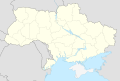 Fig. 1 Administrative map of Ukraine with borders c.2016
 -
 Fig. 2 Administrative map of Ukraine with borders c.2018
 -
 Fig. 3 Odessa Oblast borders c.2015, per File:Kodymskyi-Raion.png
 -
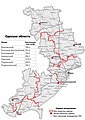 Fig. 4 Odessa Oblast borders in 2020, per File:Odessa Oblast 2020 subdivisions.jpg


- Article(s)
- Among others, see Special:GlobalUsage/Ukraine_location_map.svg
- Request
- It seems most of the maps showing the oblasts of Ukraine may require an update. For example, Figures 1 and 3 show administrative borders from around 2016, while Figures 2 and 4 show updated borders. In particular, I have noticed changes near Kodyma (Figures 3 and 4) and Kalynivske, Kherson Oblast. Thank you. —
AlphaMikeOmega(talk) 12:00, 16 June 2022 (UTC) - Discussion
- It has been pointed out to me that File:Ukraine adm location map.svg is an updated version of Figure 1. —
AlphaMikeOmega(talk) 01:15, 17 June 2022 (UTC)
Request spelling fix for File:Districts of the Bahamas (Labeled).png
-
 Labelled districts of the Bahamas
.png)
- Article(s)
- Local_government_in_The_Bahamas
- Request
- Request alteration of existing file to change Mangroove Cay (has two "o"s) to Mangrove Cay. (Center left on the largest island) See Mangrove Cay and its sources for correct spelling. — Preceding unsigned comment added by Naraht (talk • contribs) 12:58, 16 June 2022 (UTC)
- Discussion
![]() Request taken by M.Bitton (talk) 15:52, 16 June 2022 (UTC).
Request taken by M.Bitton (talk) 15:52, 16 June 2022 (UTC).
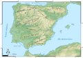
Request: Physical map of the Iberian peninsula
- Article(s)
- All ancient Spain and Portugal articles, such as Bronze of Ascoli
- Request
-

-

-
 Already existing map proposed


Right no there aren't any good quality maps of the physical geography of the Iberian peninsula. While there is a good quality physical map of Spain (this one: Reliefkarte_Spanien.png) there are not any good quality maps without the France and Portugal international borders. This would be very useful for articles that deal with ancient times, as well as purely geographical topics. In order to serve as a location map, it should probably have the same limits as this and this. 44.4° N - 34.7° N, 9.9° W - 4.8° E. — Preceding unsigned comment added by Serg!o (talk • contribs)
- Discussion
- Serg!o, do you simply want a cropped version of File:Fond de carte Tour de France-blank.svg without the administrative borders? There also appears to be this map, which I have put above, of the Iberian Peninsuala made to a high standard. — Berrely • Talk∕Contribs 19:35, 10 June 2022 (UTC)
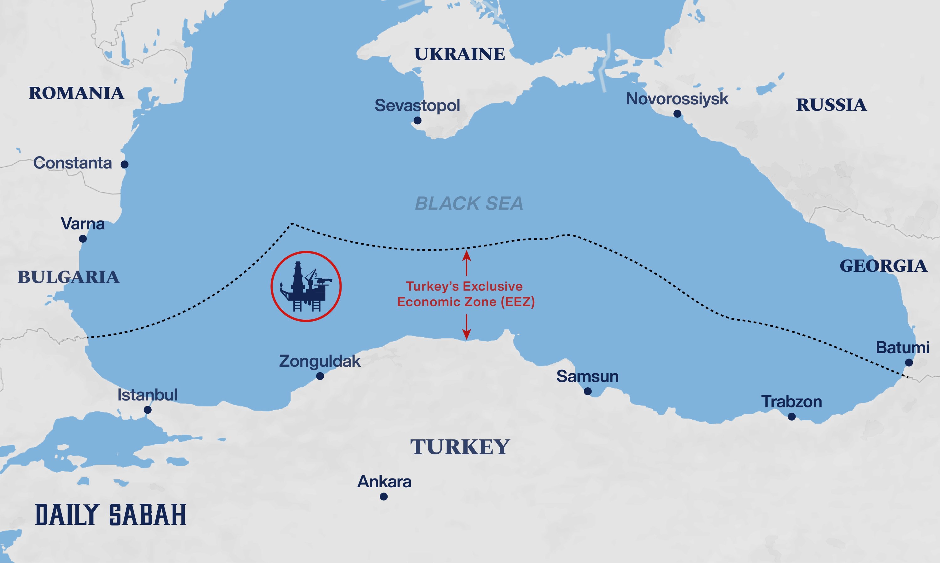
Oil and Gas in Turkey


- Article(s)
- Oil and gas in Turkey
- Request
- I think this is the first time I have requested a map (sorry could not figure out gallery and non-free images) so please let me know if I should add more details or if you have better suggestions. I am improving the above article to "good" status and I think a map would help readers. I looked in https://commons.wikimedia.org/wiki/Category:Pipelines_in_Turkey but did not see anything suitable.
Please do NOT include cancelled pipelines as that would make the map too complicated. The following pipelines could be included:
Trans-Anatolian gas pipeline with connections to Greece and Bulgaria
TurkStream and connection to Trans-Balkan pipeline
Both the above pipelines can send to both Greece and Bulgaria so please show this schematically - no need to show exact routes in Thrace
Tabriz–Ankara pipeline which is shown here middle right
Please allow for easy addition of Iraq if it ever happens
The following facilities could be shown:
Sakarya gas field which is here and Filyos Natural-gas Processing Plant and pipeline between them (maybe dashed to show under construction)
Marmara Ereğlisi LNG Import Terminal and connecting pipeline
The following storage locations could be shown IF does not make map too busy:
Please make such that all the words are easy to translate. As well as Black Sea, Ankara, Istanbul the pipelines could have a symbol to show direction of flow (only Trans-Balkan is reversible but if looks confusing please show flow going north) and symbol (arrow?) to show country/region coming from or going to namely Azerbaijan, Iran, Greece and Italy, Balkans.
Could the pipelines and facilities be clickable links to the articles?
Chidgk1 (talk) 13:29, 21 April 2022 (UTC)
- Discussion
There is a lot of description above but it is not actually complicated so I don't think it would be difficult for you. Would it help if I uploaded a rough sketch? Chidgk1 (talk) 11:43, 27 April 2022 (UTC)
![]() Bumping thread. Chidgk1 (talk) 11:55, 7 May 2022 (UTC) Please - it is fairly topical now with the news about Russia cutting off Bulgaria - so I think your work would get a lot of views. News reports such as https://eurasianet.org/southeast-europe-looks-to-azerbaijan-to-replace-russian-gas are already using maps from Wikimedia Commons but I am sure you can do much better. Chidgk1 (talk) 11:55, 7 May 2022 (UTC)
Bumping thread. Chidgk1 (talk) 11:55, 7 May 2022 (UTC) Please - it is fairly topical now with the news about Russia cutting off Bulgaria - so I think your work would get a lot of views. News reports such as https://eurasianet.org/southeast-europe-looks-to-azerbaijan-to-replace-russian-gas are already using maps from Wikimedia Commons but I am sure you can do much better. Chidgk1 (talk) 11:55, 7 May 2022 (UTC)
- Hi Chidgk1 I might start working on this— however it's a very big project, so I can't promise I'll finish it. I'll try to keep you updated on any progress I make. — Berrely • Talk∕Contribs 21:02, 10 June 2022 (UTC)
Thanks Berrely Any improvement you can make is welcome however small. Rather than an additive process as I first described an alternative possibility is for you to do a subtractive process on the very poor graphic I have knocked up (see right) and put in the article now called Oil_and_gas_in_Turkey#Transmission_and_storage . If that is easier for you then it might be improved by:
1) Remove all islands
2) Remove all lakes
3) Remove all frontiers which are not Turkish
4) Make the left hand texts "Greece to ...." clearer - not quite sure how - perhaps by cropping down the middle of the Aegean to cut out complex coastline
5) Add arrows to show flow is east to west (except the ships which are northwards in the Aegean Sea)
6) Enable easy translation
It is up to you -perhaps you prefer to start from scratch. No rush as although I have nominated the article for "good" I expect it will be weeks or months before anyone reviews it. Any questions or comments please shout on my talk page as I don't think there is a way I can just watch this section. Chidgk1 (talk) 17:24, 11 June 2022 (UTC)
Berrely The interconnector from Greece to Bulgaria is expected to open in July https://www.rferl.org/a/bulgaria-life-after-russian-gas/31860510.html so I think it would be reasonable to leave "Bulgaria" in the text as hopefully it will be flowing by the time someone gets to review the article for "good". But if you prefer to be immediately correct then remove it but please write a note to explain how I can add it back - thanks Chidgk1 (talk) 19:08, 11 June 2022 (UTC)
- @Chidgk1 do you also want the TANAP continuation through to Baku? — Berrely • Talk∕Contribs 19:34, 11 June 2022 (UTC)
Berrely Firstly thanks for responding so quickly - as you are so responsive I will add this to my watchlist and check here in future (feel free to prompt me on my talk page as well if I don't respond).
I looked at both your drafts and I think your idea on the first draft of adding the BTC oil pipeline is good. In order to clearly distinguish oil and gas I wonder if all the gas pipelines should be yellow and the oil pipeline black - would that look clear do you think?
Gas field - If pipelines yellow then perhaps the gas field should also be yellow? I think we need clarity rather than complete geographical accuracy - so the map can be somewhat schematic like the London tube map. So in order to avoid confusion between the gas field and Turkstream I suggest moving the field slightly south and maybe putting its name below it.
Add pipeline from gas field to Filyos
Suggest a lot of simplification (open to your comments/suggestions):
crop N edge to just S of Crimea
crop W edge to somewhere in Aegean Sea
crop S edge to just N of Cyprus
Remove diagonal stripes
Remove all islands, all rivers, all lakes, all frontiers which are not Turkish (to forestall irrelevant Azerbaijan Armenia frontier arguments)
Remove all geographical names except: Greece, Turkey, Iran, Russia, Ankara, Istanbul, Black Sea, Caspian Sea
Add Shah Deniz gas field also labelled Azerbaijan maybe in brackets and connect to pipeline (might need to add a Turkmen Caspian Sea field in future - not sure yet if they will connect and if so via Az or Iran)
Remove the short branch of TANAP
Do you think an icon of a LNG ship coming from Algeria would make sense or just confuse?
Change scale to km (or if difficult remove)
Continue Turkstream and TANAP to W edge of map but without crossing each other
Off or near the W edge of map write that Turkstream supplies Italy, Serbia and Hungary
Off or near the W edge of map write that TANAP supplies Italy, Bulgaria and Albania
Add a few small arrows to show direction of flow Chidgk1 (talk) 15:40, 12 June 2022 (UTC)
Berrely I just found Kirkuk–Ceyhan Oil Pipeline - please could you add that and leave the word "Iraq" on the map Chidgk1 (talk) 16:58, 12 June 2022 (UTC)
Berrely With some more digging around I found that https://www.gem.wiki/Tabriz-Ankara_Pipeline have cited Tabriz–Ankara pipeline to say that "In Erzurum, the Tabriz-Ankara Pipeline is linked to the South Caucasus Pipeline" whereas our article has no cite. https://www.swp-berlin.org/en/publication/turkey-and-european-energy-insecurity seems to be clear that the Iranian gas does not go to Europe. So I think we should draw the pipeline schematically as clearly not connected to TANAP Chidgk1 (talk) 18:48, 12 June 2022 (UTC)
Berrely Actually it will be easier for reader if we just label as Southern Gas Corridor rather than TANAP and South Caucasus Pipeline Chidgk1 (talk) 19:01, 12 June 2022 (UTC)
Berrely I just found a map at https://enerji.gov.tr/bilgi-merkezi-haritalar which is obviously much more detailed than we need but can presumably be cited as the source of the info? Chidgk1 (talk) 07:14, 16 June 2022 (UTC)
- Chidgk1 apologies for the radio silence. I think for now just doing natural gas routes would be better to reduce clutter, though other pipelines can be introduced later is there is sufficient space. I will make sure to carry out the suggestions you made above. Thanks! — Berrely • Talk∕Contribs 14:05, 18 June 2022 (UTC)
- Chidgk1, so you understand this, allow me to explain my workflow to you:
- First I research the map using the data you provided and other sources I found
- Then I create the map to the best extent possible in a GIS software, which allows manipulation of geographic data.
- Then I import this into Adobe Illustrator and modify the generated SVG by hand to make it better.
- Some of the things you requested, like the arrows and continuation, are easier to do in step 3. So, I will add those things later on.
For now, this is my draft. I have incorporated most of the things you suggested, but have retained some others like country borders, which I think are important to show what countries the gas is being transported through. If you want I can make multiple versions with and without the borders.So, before I do step 3, I want to ask what changes you want to make to the above map. What modifications you need, etc. Whilst I can do it later, it is harder. — Berrely • Talk∕Contribs 15:10, 18 June 2022 (UTC)- Also, with the LNG ship from Algeria, it's your choice :). It depends on whether you want this to be a pipeline map or an overall natural gas map. I'd go against as then I'd probably also have to add all the routes that natural gas is shipped to Turkey. — Berrely • Talk∕Contribs 15:12, 18 June 2022 (UTC)
- Take your time - my GAN has failed for non-map reasons so I have a lot of work to do on the text before I put it in again. Yes on reflection I think you are right that having separate maps for oil and gas will be clearer. Re the LNG I am guessing that Turkey will just buy from Algeria as that is the only LNG contract we have. Because with Italy buying less from Russia there is plenty of spare pipeline capacity, so why would we want to buy more LNG as that would be more expensive than pipeline gas? Your map is definitely better but I am still concerned about people getting into irrelevant political arguments in future. Although it will make the map very thin I still think the northern boundary should be just south of Crimea otherwise people might complain that Ukraine should be labelled. Re Tabriz-Ankara I don't think it goes through any other country except Iran and Turkey. So please remove the word "Armenia" otherwise we risk Azerbaijan/Armenia arguments in future. I have never used GIS software - where did the pipeline routes come from please? More comments follow later. Chidgk1 (talk) 16:22, 18 June 2022 (UTC)
- @Chidgk1 the pipeline routes came from OpenStreetMap, and research I did to find maps from BP and Gazprom for other pipelines. I cross-checked everything with other available maps as well. For example the gas field I got from a energy research journal. — Berrely • Talk∕Contribs 20:11, 18 June 2022 (UTC)
- Berrely Thanks for researching. I don't doubt the other pipelines and gas field but specifically the Tabriz-Ankara? I wonder if there might be a mistake in the source you used as I am very surprised that the source would show it going outside of Iran and Turkey, as the map on the official website above does not show that. I am not an expert on OSM but I have edited there occasionally. I cannot see Tabriz-Ankara at https://www.openstreetmap.org/relation/1690067 Please could you write the link for your source. Chidgk1 (talk) 13:50, 19 June 2022 (UTC)
- Ah it might be https://www.openstreetmap.org/edit?relation=1690067#map=15/39.4142/44.3826 which comes from the Iranian border Chidgk1 (talk) 13:58, 19 June 2022 (UTC)
- @Chidgk1 the pipeline routes came from OpenStreetMap, and research I did to find maps from BP and Gazprom for other pipelines. I cross-checked everything with other available maps as well. For example the gas field I got from a energy research journal. — Berrely • Talk∕Contribs 20:11, 18 June 2022 (UTC)
- Take your time - my GAN has failed for non-map reasons so I have a lot of work to do on the text before I put it in again. Yes on reflection I think you are right that having separate maps for oil and gas will be clearer. Re the LNG I am guessing that Turkey will just buy from Algeria as that is the only LNG contract we have. Because with Italy buying less from Russia there is plenty of spare pipeline capacity, so why would we want to buy more LNG as that would be more expensive than pipeline gas? Your map is definitely better but I am still concerned about people getting into irrelevant political arguments in future. Although it will make the map very thin I still think the northern boundary should be just south of Crimea otherwise people might complain that Ukraine should be labelled. Re Tabriz-Ankara I don't think it goes through any other country except Iran and Turkey. So please remove the word "Armenia" otherwise we risk Azerbaijan/Armenia arguments in future. I have never used GIS software - where did the pipeline routes come from please? More comments follow later. Chidgk1 (talk) 16:22, 18 June 2022 (UTC)
- Also, with the LNG ship from Algeria, it's your choice :). It depends on whether you want this to be a pipeline map or an overall natural gas map. I'd go against as then I'd probably also have to add all the routes that natural gas is shipped to Turkey. — Berrely • Talk∕Contribs 15:12, 18 June 2022 (UTC)
- Chidgk1, so you understand this, allow me to explain my workflow to you:
Request for Municipal maps of Albania and new Locator map of Albania
-
 Location map
 -
 Map showing a county
 -
 Map showing a municipality
 -
 Map showing a municipality within a county
.svg)
.svg)
.svg)
.svg)
- Article(s)
- Municipalities of Albania
- In all articles of each individual municipality of Albania
- In all articles of towns and villages of Albania
- Request
- Hello everyone, there are currently no up to date municipal maps of Albania that follow Wikipedia's conventions. In 2015 the Albanian government passed a law which changed the municipalities of the country. The current locator map which is used for almost all Albanian cities is also outdated:[1].
![[1]](https://commons.wikimedia.org/wiki/File:Albania_location_map.svg)
- Maps with the outline of the new municipalities have already been made and you can find them over here: [2][3] However they do not follow the conventional 'red'-'gray'-'dark gray' display which can be found all over Wikipedia.
![[2]](https://commons.wikimedia.org/wiki/File:Harta_e_Bashkive.svg)
![[3]](https://commons.wikimedia.org/wiki/File:Bashkia_e_Belshit_në_Hartën_e_Shqipërisë.svg)
- What we need is a map for each municipality where all of Albania is colored in light yellowish gray, the municipality is colored in red and the neighboring countries of Kosovo, North Macedonia, Greece and Montenegro are colored in dark gray. In these zoomed-out views, three types of borders are needed: one type for the borders of the countries, another type for the counties and another one for the municipalities.
- We also need one new locator map (without the red coloring) which will be used for the cities and towns of Albania.
- Most of the municipalities are quite small, that is why we also need zoomed-in views of the municipalities on itself. I don't know if we need to add the zoomed-in views in the same map as the zoomed out-views or if we should make two separate maps for each municipality. Any suggestions here? What I do know is that in the zoomed-in views we also need to add a fourth type of border which will demarcate the municipal units. Here you can find a map which includes the municipal units: [4]
![[4]](https://commons.wikimedia.org/wiki/File:Harta_e_Njësive_Vendore.svg)
- The source for all the borders can be found over here: [5]
- For the names of the files we should preferably use the Albanian names as are used in the source.
- I would also like to emphasize the need that the borders are to be drawn with accuracy (if possible with the same accuracy as the maps of the municipalities mentioned above which were drawn by Kj1595). Also, I don't think we should include rivers.
- Thank you to whomever is willing to make the maps! Ahmet Q. (talk) 10:54, 1 June 2022 (UTC)
- Discussion
@Ahmet Q.: I've had a look at the cited maps (namely [6] and [7]) and I can see what appears to be a problem: the borders of the municipal units do not align with those of the municipalities. Am I mistaken in assuming that they should? M.Bitton (talk) 14:02, 6 June 2022 (UTC)
- Hello, M.Bitton. Yes they should most definitely align with each other. If they don't then it means that there are errors in those maps. The maps at the last pages of the provided pdf should be used as the reference, anything different from those maps is most likely a mistake. Ahmet Q. (talk) 18:01, 6 June 2022 (UTC)
- @Ahmet Q.: I thought so. Is there a mention in that PDF of the map projection used? M.Bitton (talk) 18:07, 6 June 2022 (UTC)
- Yes, apparently each map has a different projection. They are mentioned under the title of each map. Ahmet Q. (talk) 18:11, 6 June 2022 (UTC)
- Unfortunately, I can't read Albanian. M.Bitton (talk) 18:14, 6 June 2022 (UTC)
- Oh my bad I thought you were talking about the scale for some reason, I have no idea what projection they used. Ahmet Q. (talk) 18:17, 6 June 2022 (UTC)
- I started working on the main map (without the municipal units). M.Bitton (talk) 16:04, 11 June 2022 (UTC)
- There is a higher quality map here, its in svg and cointains both municipalities and municipal units, adn one only for municipalities here. AT44 (talk) 16:12, 14 June 2022 (UTC)
- I started working on the main map (without the municipal units). M.Bitton (talk) 16:04, 11 June 2022 (UTC)
- Oh my bad I thought you were talking about the scale for some reason, I have no idea what projection they used. Ahmet Q. (talk) 18:17, 6 June 2022 (UTC)
- Unfortunately, I can't read Albanian. M.Bitton (talk) 18:14, 6 June 2022 (UTC)
- Yes, apparently each map has a different projection. They are mentioned under the title of each map. Ahmet Q. (talk) 18:11, 6 June 2022 (UTC)
- @Ahmet Q.: I thought so. Is there a mention in that PDF of the map projection used? M.Bitton (talk) 18:07, 6 June 2022 (UTC)
- @Ahmet Q.: please have a look at the new maps and let me know what you think. M.Bitton (talk) 17:22, 17 June 2022 (UTC)
- Hi @M.Bitton, really nice work! I think we can already use your locator map for all the villages. I personally prefer the third over the fourth map, I am not sure how we can use both maps in the same article? Maybe one remark would be the thickness of the borders, considering that we are also going to use another thickness for the municipal units, shouldn't we use a more pronounced border to make it easier to differentiate them from each other; or maybe we could use something like dotted lines for the municipal units? In that way we wouldn't need to change the thickness. What do you think? I forgot what Wikipedia's conventions for maps recommend for the borders of administrative maps, I will have to check them again. Ahmet Q. (talk) 07:18, 27 June 2022 (UTC)
Geothermal power plants in Turkey
- Article(s)
- Geothermal energy in Turkey
- Request
- Something like the above but only operational, but there are now 63 so it needs to be such that a non-graphist can easily add more -- Chidgk1 (talk) 07:22, 29 June 2022 (UTC)
- Discussion