
Wikipedia:Graphics Lab/Map workshop/Archive/Mar 2020
| This page is an archive. Do not edit the contents of this page. Please direct any additional comments to the current main page. |

Switch highlights
-
 Meant to be a map of Richmond

- Article(s)
- Used on 27 pages on en:wp, and on 62 pages on 56 other wikis
- Request
- This map is intended to depict the location of the city of Richmond, Virginia, but by some mistake it accidentally highlights the unrelated Richmond County, Virginia. (Note that File:Map of Virginia highlighting Richmond County.svg properly highlights the county.) Could you take off the current highlight and add a new highlight for the city? For the city location: if you look at File:Map of Virginia highlighting Henrico County.svg, you'll see that this map's highlighted area is like a "U", with another blob in the middle. That blob is the city of Richmond. And finally, since the Richmond city map is used to represent the city, and has the right name and everything, please overwrite the existing map, and don't edit any other files. Thanks! Nyttend (talk) 02:25, 1 March 2020 (UTC)
- Discussion
Quifangondo Portuguese translation
-
 Need translation to English

- Article(s)
- Used on Battle of Quifangondo
- Request
- This map depicts the movements and positions of the opposing forces in the Battle of Quifangondo, during the Angolan Civil War. Unfortunately it's only available in Portuguese. Perhaps one of the resident Portuguese-speaking mapmakers here can give me a hand with an English language version? Thanks! --Katangais (talk) 21:48, 2 March 2020 (UTC)
- Discussion
Requesting map of New York City Assembly districts from the 1920s
{{resolved}}
-
 A map of the contemporary Assembly districts of Manhattan; I'd like a version with all five boroughs.
- Article(s)
- Several, including 1929 New York City mayoral election, etc.
- Request
- I have been working on old New York City municipal elections for a while, particularly of the 1920s and 1930s, and would like to have maps of the Assembly districts from that time. I already have the boundaries from the 1919 World Almanac here (for those inclined, the individual election district boundaries can be found in the 1918 Almanac here; unfortunately upstate districts, which from what I could gather were drawn by the relevant county prior to the 1960s, are not found in either of them), but given my ignorance of the streets outside of Manhattan as well as how to make complicated shapes in SVG I would be much obliged if someone could make the map. (As shown in the gallery above, I've already made a PNG map for Manhattan and can make ones for each individual borough, but I'd like a full citywide map.) If you make the map in SVG, please annotate which district is which in the source code as I use a text editor to manipulate vector graphics. (I also have a source for aldermanic districts from this time, but it's several days of the Brooklyn Daily Eagle that is lower resolution, and is less important.) I asked WikiProject NYC for this and was referred here.
- Thanks for your help. A barnstar awaits the person who takes me up on this.
- – John M Wolfson (talk • contribs) 00:38, 17 February 2020 (UTC)
- Discussion
- Please make Randalls and Wards Islands historically accurate as I did with the Manhattan map; they weren't joined together until the 1950s and 1960s. This matters here because Wards Island was a part of NY County's 18th district and Randalls Island (and Sunken Meadow to its east) was a part of NY County's 20th district. – John M Wolfson (talk • contribs) 01:03, 17 February 2020 (UTC)
- Comment/Idea: Would it be easier for me to make maps of the various boroughs as I've done above, and then for someone else to photoshop/GIMP them into a single citywide map? It would make them the most geographically accurate and it may or may not be as much work. – John M Wolfson (talk • contribs) 01:21, 17 February 2020 (UTC)
- Update: I have now made a map of the districts in the Bronx here. I get the feeling that one can use cage transform in Photoshop/GIMP to unify the borough maps into a single citywide map, although I haven't been able to do so myself. – John M Wolfson (talk • contribs) 01:03, 17 March 2020 (UTC)
- All five boroughs are available I have now created maps for all five boroughs (Manhattan, the Bronx, Brooklyn, Queens, and Richmond/Staten Island) if anyone would like to merge them into a single citywide map. – John M Wolfson (talk • contribs) 16:27, 20 March 2020 (UTC)
 Done The map is here. Cleanup and adding the Jamaica Bay islands would be much appreciated, but the map is mainly done. – John M Wolfson (talk • contribs) 19:23, 21 March 2020 (UTC)
Child pornography law map

- Article(s)
- Request
The United Kingdom and the Republic of Ireland should both be coloured either orange or yellow on this map denoting the illegality of child pornography in both countries. I'm not sure which as I'm not sure how either country regards the matter in a fictional sense, but I'm sure ample information is available to be found. This may also be helpful - Child pornography laws in the United Kingdom. Helper201 (talk) 05:19, 11 October 2019 (UTC)
- Discussion
- The color scheme is odd, as it seems to imply that child pornography should be legal. Perhaps something other than the red-green spectrum should be used. – John M Wolfson (talk • contribs) 16:10, 20 March 2020 (UTC)
- Partially done I filled in the UK but don't know about whether Ireland allows real depictions should be used. I also changed the color scheme to address my earlier concern. – John M Wolfson (talk • contribs) 11:50, 21 March 2020 (UTC)
Achaemenid Empire and Royal Road
-
 The existing map with the Royal Road highlighted.
 -
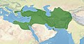 More accurate map showing the extend of Achaemenid Persia.
 -
 Another map, showing the development.


.svg)
- Article(s)
- Royal Road
- Silk Road
- Historic roads and trails
- Request
- The map used in the Royal Road article needs to be fixed or renewed, because it suggests that the Achaemenid Empire was "open-ended" in the Northeast. -- bender235 (talk) 17:37, 6 May 2020 (UTC)
- Discussion
- And just as I was looking for more examples, I saw that in the image description of the second map above, there was a relatively new map of the royal road uploaded already. {{resolved}}
Prostitution in Europe map

- Article(s)
- Request
Per what is stated in the main text of the Prostitution in Europe article, Bosnia and Herzegovina should be blue on this map and not red, as according to the main text of the linked page prostitution is legal in the country, but related activities such as solicitation and keeping a brothel are illegal. However, by having the country coloured red on the map it contradicts this by signifying that prostitution is illegal in the country. Helper201 (talk) 23:01, 23 March 2020 (UTC)
- Discussion
Biblical Mount Sinai

- Article(s)
- Biblical Mount Sinai
- Request
- Could this map be focused in so that the labels don't overlap so much? This is the lead image in a highly visible article. Thank you. Onceinawhile (talk) 07:18, 11 May 2020 (UTC)
- Discussion
- Onceinawhile Changing the basemap to be Egypt Sinai, made markers smaller when overlapping and updated the caption with locations off map. This provides a quick solution that is easy to maintain.

- Otherwise, a custom map would be needed since the SVG locator maps don't cover the region in enough detail for this purpose. A custom map would not be as easy to edit and would require time and effort to develop. Let me know if you think this partial solution is sufficient. - DutchTreat (talk) 17:20, 12 May 2020 (UTC)
- Updated caption in proposal. - DutchTreat (talk) 17:27, 12 May 2020 (UTC)
- Thank you very much for this. This is an improvement. Your points re the custom map are very fair – I have opened a discussion at Module_talk:Location_map#Cropping_maps regarding an alternate way of solving the problem which would also open up many new possibilities for the location map template. Onceinawhile (talk) 21:06, 12 May 2020 (UTC)
- FYI, other options include the method described in {{CSS crop}} (see this version of the article) or using {{OSM Location map}} which doesn't require making new maps for every region. Frietjes (talk) 00:00, 13 May 2020 (UTC)
- Thank you Frietjes, and for fixing the article itself. It looks great! Onceinawhile (talk) 07:56, 13 May 2020 (UTC)
- @Frietjes: FYI I have copied your trick at the map Paris Peace Conference (1919–1920). Onceinawhile (talk) 08:10, 13 May 2020 (UTC)
- Thank you Frietjes, and for fixing the article itself. It looks great! Onceinawhile (talk) 07:56, 13 May 2020 (UTC)
- FYI, other options include the method described in {{CSS crop}} (see this version of the article) or using {{OSM Location map}} which doesn't require making new maps for every region. Frietjes (talk) 00:00, 13 May 2020 (UTC)
- Onceinawhile Looks to me like your request is complete. If so, please add {{Resolved}}. - DutchTreat (talk) 09:57, 15 May 2020 (UTC)
- Yes it is. Thanks to all. Onceinawhile (talk) 12:58, 15 May 2020 (UTC)
- Thank you very much for this. This is an improvement. Your points re the custom map are very fair – I have opened a discussion at Module_talk:Location_map#Cropping_maps regarding an alternate way of solving the problem which would also open up many new possibilities for the location map template. Onceinawhile (talk) 21:06, 12 May 2020 (UTC)
{{resolved}}