
Wikipedia:Graphics Lab/Map workshop/Archive/Jul 2018
| This page is an archive. Do not edit the contents of this page. Please direct any additional comments to the current main page. |

-
 Map of Israel Railways passenger lines and stations in Hebrew and English

- Article(s)
- Israel Railways
- Request
- Please extend the northern end of the red line to include the Ra'anana stations, as indicated on the official map in English and in Hebrew. עוד מישהו Od Mishehu 08:27, 5 July 2018 (UTC)
- Graphist opinion(s)
New map for Alaska
-
 Current best option
 -
 Worst option, anything but this
.svg)

- Article(s)
- Alaska and related articles
- Request
- We had a discussion on the talk page about the fact that many articles still use the awful style of map of the US that shows Alaska, very much not to scale, in a box off the coast of California. Nobody wants to use that in articles about Alaska. Currently the above image is what we’ve got to go with. It correctly shows the scale and location of Alaska, but there was some desire for a different version, showing just Alaska, adjoining areas of Canada, and the Pacific Northwest, with only Alaska being shaded. -- Beeblebrox (talk) 17:58, 6 July 2018 (UTC)
- Graphist opinion(s)
- I had requested on the talk page that we use the tan and yellow colors of the "bad" map. YoPienso (talk) 18:12, 6 July 2018 (UTC)
- Request
- Hi. Could you please get a more accurate map with the description of the names of the gates according to their directions? Thanks. Shaimosmos (talk) 13:07, 29 May 2018 (UTC)
- the name of the gate is "Khorasan" and not "Kursan". Shaimosmos (talk) 16:10, 6 June 2018 (UTC)
- can you please make a "new map" instead of this bad map ?. Shaimosmos (talk) 10:37, 8 July 2018 (UTC)
Change to File:Map_Iran_1900-en.png requested
- Request
Could you change "Britannic influence" to "British influence" in File:Map_Iran_1900-en.png. Thanks. Basemetal 12:20, 9 July 2018 (UTC)
- Graphist opinion(s)
Request close up maps of the University of Georgia campus sections
-
Bounded by Baldwin Street, Lumpkin Street, Broad Street and East Campus Road (please include boundary streets as part of image)
-
Bounded by Field Street, Lumpkin Street, Baldwin Street and East Campus Road
-
Bounded by Field Street, and East Campus Road, reach south as far as Driftmier Engineering Center and west as far as J.W. Fanning Building
- Article(s)
- University of Georgia
- Request
- Please upload updated maps of the UGA campus as described. The are available at https://www.openstreetmap.org/#map=15/33.9491/-83.3788 --- Coffeeandcrumbs 08:02, 15 July 2018 (UTC)
- Graphist opinion(s)
Commonwealth Realms (Current and Former)

- Article(s)
- Commonwealth realm
- Request
- Alright, would it be possible for someone to create a separate SVG file of the version of this map from 17 March 2012 (visible on File history), which shows both the current and former Commonwealth realms. I think this map would be rather useful to have on Wikipedia. Thanks. User:Snow Lion Fenian
- Graphist opinion(s)
Map of East Timor
-
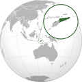 Map of East Timor
.svg)
- Article(s)
- East Timor
- Request
- Please make the zoomed out map of the island of Timor more detail including the boundary between the country. If you notice the region of Oecusse is too small. Also don't forget about the detail of surrounding islands. Thank you.-- Hddty. (talk) 10:09, 27 July 2018 (UTC)
- Graphist opinion(s)