
Wikipedia:Graphics Lab/Map workshop/Archive/Apr 2011
Stale[edit]
Article(s): Terai
Request: Please create a map for the article (maybe similar to File:Indo-Gangetic Plain.png?)
WWF: Map of ecological divisions of Nepal, showing the Terai 78.55.207.248 (talk) 07:48, 1 February 2011 (UTC)
Graphist opinion:
United Kingdom Population density map[edit]
Article(s): United Kingdom
Request:I am here to ask you to please make a map showing the population density of the United Kingdom and its territories and crown dependencies. I two examples of the type of map in which I am referring to is the Spanish map- File:EspDens2.jpg and also the French map - File:France_population_density_40pc.png Thank You Rctycoplay (talk) 16:17, 7 February 2011 (UTC)
Graphist opinion:
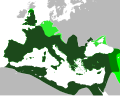
Roman Empire map - needs correcting[edit]
-
 The map that needs to be corrected
 -
 A map showing correct borders
.svg)

Article(s): Roman Empire
Request: In the orthographic projection, the Roman Empire's northern border (from the western edge of the Black Sea to the North Sea needs to be corrected. The northern border of Roman Britain also needs to be slightly adjusted. The second map shows the correct borders. The rest of the borders could also use some cleanup, so anything else that brings it closer to the second map would be appreciated. Swarm X 07:29, 8 February 2011 (UTC)
Graphist opinion(s):
Town of Bergen, New Jersey[edit]
Article(s): Bergen City, New Jersey
Request: I just added an 1868 legal boundry description to the Bergen City, New Jersey article of the no-longer-existing Town of Bergen, New Jersey. If you have time, please post a modern map with lines showing the boundary. Also, a map for Bergen Township, New Jersey (1893–1902) and Centre Township, New Jersey, please, using the legal boundry description posted there. Uzma Gamal (talk) 15:45, 8 February 2011 (UTC)
Graphist opinion(s):
Historic map of Arabia[edit]
Article(s): Saudi Arabia,History of Saudi Arabia
Request: The labeling on the map is very small (and can't be read even in History of Saudi Arabia where it's 350px, can they be made bigger to be more readable? The only labels that need to be made bigger are the ones in the main blue area, the green area (labeled Hejaz) on Red sea coast, and the yellow area (labled upper Asir) in the bottom left. There seems to be plenty of space to do it. The other labels in the other areas are not relevant to the articles so can stay small. The other thing is there are dates under the label written in a strange way with year and month running into each other eg "192207". Can they be changed to eg "07/1922" or, preferably, if there is enough room "July 1922" DeCausa (talk) 09:15, 12 February 2011 (UTC)
Graphist opinion(s):
Battle of Wagram map(s)[edit]
-
 Helpful map of one of the stages of the battle.
 -
 This is a very detailed map of operations during the 2-day battle. It is overloaded with info, and would need to be broken down, according to the stages of the battle.
 -
 a basic map that could be used in making the requested map. It shows the basic geography of the battlefield.


Article(s): Battle of Wagram (Major expansion of the article to come).
Request: Create a few well-illustrated and catchy maps of the battle. Ideally, 4 maps would be needed (see below). Alexandru Demian (talk) 16:38, 12 February 2011 (UTC)
Hello, I am currently preparing a major expansion of the article about the battle of Wagram. I need a few well-illustrated and complete maps, such as of the Gebora-en.svg the one you have made for the battle of Gebora. Ideally, four maps would be needed:
- 1. one map showing operations on 5 July: the French crossing of the Danube
- 2. one map showing operations on 5 July: the evening attacks.
- 3. one map showing the early operations on 6 July
- 4. one map showing the French attacks and Austrian retreat late on 6 July.
Some good maps are available here. There are also some very reliable and well illustrated maps of the battle in Ian Castle's "Aspern & Wagram 1809: Mighty Clash Of Empires".--Alexandru Demian (talk) 16:38, 12 February 2011 (UTC)
Graphist opinion:
Gateway Project[edit]
Article(s): Gateway Project
Request:
Would be great to have a detailed map of this planned new high speed rail corridor, info for which gives an idea... Djflem (talk) 00:27, 18 February 2011 (UTC)
Graphist opinion(s):
Battle of Attock[edit]
-
 Put in this gallery any maps that may be helpful; style wished, other style ok too File:Battle of Attock or Chuch - Military system of the Sikhs during the period 1799-1849 - Fauja Singh.jpg

Article(s): Battle of Attock
Request: Please create a proper battle map, I've uploaded tons of proper battle maps from military sources so I would appreciate it if someone could return the favor. Thank you Profitoftruth85 (talk) 02:19, 22 February 2011 (UTC)
Graphist opinion:
Benghazi Map[edit]
-
 Map of the Mutamarat Shabiya (local divisions) within the Benghazi shabiya (top level national division).

Article(s): Benghazi
Request: Please vectorise the map and make it look nice.
Graphist opinion(s):
Jaw101ie (talk) 19:49, 20 January 2011 (UTC)
- Jaw101ie - I'm working on the map and will try to get it done in the next day. We're also working on improving OpenStreetMap coverage for Benghazi. [1] --Aude (talk) 17:15, 22 February 2011 (UTC)
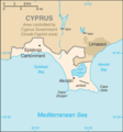
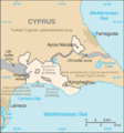
List of Sovereign states and dependent territories in Europe[edit]
-
 Guernsey png
 -
 Akrotiri and Dhekelia location on Cyprus map
 -
 Better Akrotiri
 -
 Better Dhekelia


Article(s): List of sovereign states and dependent territories in Europe
Request: Convert the Guernsey and Akrotiri and Dhekelia maps into svg's. Couple of other maps need editing for the article, but this would be a good first step. Thanks, Chipmunkdavis (talk) 15:09, 23 February 2011 (UTC)
Graphist opinion:
Resolved[edit]
[edit]
-
 Use this map or another that may not be cropped as much
 -
 Graphist rendition (note the striped area is an overlap between two Naval Areas)


Article(s): Sri Lanka Navy (please add to page when complete; under the organization section)
Request: Please utilize the sources below to create a map depicting the area of operations for the Sri Lanka Navy as best you see fit. Each page has specific geo-locations. Thank you. Evan.oltmanns (talk) 13:38, 23 March 2011 (UTC)
Northwestern Naval Area - http://www.navy.lk/index.php?id=2910
Eastern Naval Area - http://www.navy.lk/index.php?id=98
North Central Naval Area - http://www.navy.lk/index.php?id=95
Northern Naval Area - http://www.navy.lk/index.php?id=96
Southern Naval Area - http://www.navy.lk/index.php?id=97
Western Naval Area - http://www.navy.lk/index.php?id=93
Graphist opinion: I originally intended to simply create lines indicating the boundaries between the different naval areas. However, this became untenable once I discovered that the Southern and Eastern areas overlapped. So, instead, I created the map using different colors to indicate the different naval areas. I enabled transparency so that the overlap between the Southern area (blue) and the Eastern area (purple) would be visible (indigo). The image is a bit crowded for labels to be realistic, but I can put them in if you want them. Ninjatacoshell (talk) 17:55, 28 March 2011 (UTC)
- I think the graphic is along the lines of what I was looking for but I am not sure about the use of colors; I find them to be a bit distracting. Your original intentions seem to be in line with what I had in mind and, although I was unaware of the overlap, I do not see the area as a big issue. I think the best fix for that would be to simply add an area of hash marks and describe the overlap somewhere on the article, as a caption, or on the image page. Labeling may then be an issue though maybe we can use acronyms such as: NwNA (or NWNA), NcNA (or NCNA), ENA, WNA, SNA, and NNA. What are your thoughts? Evan.oltmanns (talk) 19:45, 28 March 2011 (UTC)
- So you'd like just lines for the boundaries except for the overlap, which would be hashed or striped? I think that might work, if that's what you're saying. Or if you like the colored boundaries, but not the particular colors that I chose, do you have suggestions? As for the labels, I think acronyms would work. Or just Eastern, Northwestern, etc. Whatever you want. Ninjatacoshell (talk) 01:04, 29 March 2011 (UTC)
- I think the best thing to do for now would be to reduce the clutter of the image and wait and see what others say about it in the future. I will try to find someone who works on military maps exclusively but if I am unable to locate anyone we can just leave it as is (following the two suggestions I have) for now. I think one of two ways would be best; I made a Google Docs drawing with my two ideas (hopefully you can get a sense of what I mean in my second idea, if its not clear let me know): https://docs.google.com/drawings/edit?id=1d4PzO_Fg2aMRObNUySiftgxHH6aW9AzCiNkPNTMauEo&hl=en&authkey=COjhn4IJ (hopefully that link works for you) I like how you have the description of what the colors are in the picture page so maybe we can have something similar regarding the acronym labels. Thanks again for your help. Evan.oltmanns (talk) 23:13, 29 March 2011 (UTC)
- I played around with your second example, but everything I tried just looked cheesy. And the colored text is hard to read. So I went with your first example. I changed the lines to a dark cyan so that they don't look so garish against the pale map. I can change it to a different color, if you like. One more question: Do you think we should leave the little bit of India that is visible or remove it? Ninjatacoshell (talk) 00:37, 30 March 2011 (UTC)
- That looks awesome. I don't see any reason to remove the bit of India; its just the way it is. The only other thing that I think the image would need is location markers (like the map on this page http://en.wikipedia.org/wiki/Sri_Jayawardenapura-Kotte) for the headquarters of each Naval Area but that is something I do not have at this time (not even sure if each has a HQ anyway) so its a non-issue. Anyways, looks good and thanks for your diligence. I'll contact you if I should think of anything different. Evan.oltmanns (talk) 04:44, 30 March 2011 (UTC)
- I played around with your second example, but everything I tried just looked cheesy. And the colored text is hard to read. So I went with your first example. I changed the lines to a dark cyan so that they don't look so garish against the pale map. I can change it to a different color, if you like. One more question: Do you think we should leave the little bit of India that is visible or remove it? Ninjatacoshell (talk) 00:37, 30 March 2011 (UTC)
- I think the best thing to do for now would be to reduce the clutter of the image and wait and see what others say about it in the future. I will try to find someone who works on military maps exclusively but if I am unable to locate anyone we can just leave it as is (following the two suggestions I have) for now. I think one of two ways would be best; I made a Google Docs drawing with my two ideas (hopefully you can get a sense of what I mean in my second idea, if its not clear let me know): https://docs.google.com/drawings/edit?id=1d4PzO_Fg2aMRObNUySiftgxHH6aW9AzCiNkPNTMauEo&hl=en&authkey=COjhn4IJ (hopefully that link works for you) I like how you have the description of what the colors are in the picture page so maybe we can have something similar regarding the acronym labels. Thanks again for your help. Evan.oltmanns (talk) 23:13, 29 March 2011 (UTC)
- So you'd like just lines for the boundaries except for the overlap, which would be hashed or striped? I think that might work, if that's what you're saying. Or if you like the colored boundaries, but not the particular colors that I chose, do you have suggestions? As for the labels, I think acronyms would work. Or just Eastern, Northwestern, etc. Whatever you want. Ninjatacoshell (talk) 01:04, 29 March 2011 (UTC)
United States Military Entrance Processing Command map[edit]
-
 Good base map the easiest to manipulate, though San Juan would need to be added.
 -
 Version with San Juan but the other territories would need to be removed.
.svg)

Article(s): United States Military Entrance Processing Command
Request: Requesting an SVG map be made to represent the location of all United States Military Entrance Processing Command stations. The United States Military Entrance Processing Command page has a complete listing of locations and a reference map can be found at http://www.mepcom.army.mil/meps/index.html which has links to each station and their actual address. It might be good to differentiate the Eastern and Western sectors as they do on the .mil page or use two different colored markers. Thank you. Evan.oltmanns (talk) 11:20, 7 April 2011 (UTC)
Graphist opinion: Did my best, hope you like it:
- Looks great. Thank you. Evan.oltmanns (talk) 11:48, 8 April 2011 (UTC)

--Sisyphos23 (talk) 14:08, 7 April 2011 (UTC)
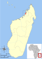
Map of Masoala National Park[edit]
-
 The current, low-res map
 -
 Something similar to this might be nice
 -
 Here's the source
 -
 Another possibility


Article(s): Masoala National Park
Request: I would like to replace the low-res map on this article with something better. I recently rewrote Marojejy National Park and plan to eventually re-write this article as well. We clearly need a much better map. – VisionHolder « talk » 16:20, 17 February 2011 (UTC)
Graphist opinion(s):What do you think?--Sisyphos23 (talk) 17:54, 7 April 2011 (UTC)
- Sorry I missed this. This looks excellent! Thank you very much! – VisionHolder « talk » 12:37, 9 April 2011 (UTC)

![]() Request taken by Sisyphos23.
Request taken by Sisyphos23.
Skanderbeg's Albania[edit]
-
 Possible basis for map.

Article(s): Skanderbeg and other articles
Request: Hello. I would like to see if anyone could make a map for Skanderbeg's Albania. I have plans to have all of the major settlements, fortresses, and battles labeled, and maybe even routes of invasion. This map may require some work and research, but I will be able to help all of the way through. Of course, I would also like the borders to be drawn and maybe even their changes to be shown. I also have a map (not under WikiLicense) of Albania's important roads which may be useful. If anybody is willing to undertake this, I would be very glad as I have been trying to have something like this for over a year now. With kind regards, Gaius Claudius Nero (talk) 22:52, 25 March 2011 (UTC).
Graphist opinion(s): Never mind. I figured out how to do it myself.--Gaius Claudius Nero (talk) 00:35, 11 April 2011 (UTC)
Japan[edit]

Article(s): Japan
Request: remove top caption as unrelated, make background transparent.--Kintetsubuffalo (talk) 14:05, 16 April 2011 (UTC)
Graphist opinion(s): ![]() Done Overwitten; First time working on a map, I hope this works for your purpose. – Kerαunoςcopia◁galaxies 22:30, 20 April 2011 (UTC)
Done Overwitten; First time working on a map, I hope this works for your purpose. – Kerαunoςcopia◁galaxies 22:30, 20 April 2011 (UTC)
- Thank you, that's great! Thank you also for pinging me on my talkpage, work has been busy. You rock!--Kintetsubuffalo (talk) 03:14, 24 April 2011 (UTC)
Planned and actual route of marchers on Bloody Sunday 1972[edit]
Article(s): Bloody Sunday (1972), Bloody Sunday Inquiry, Narrative of events of Bloody Sunday (1972)
Request: A map that shows the planned route, and then the actual route of civil rights marchers on 30th January 1972 in Derry, Northern Ireland. A description of the planned and actual route (see Section 3.4) as well as several maps are shown here: [2], with another version here: [3] AFAIK the largest blank version of the map: [4] The Report is under Crown Copyright. I would be happy to answer any questions, thanks for your consideration. LoveUxoxo (talk) 01:44, 22 April 2011 (UTC)
Comment: this editor has already been advised about the unacceptable use of this image at WP:MCQ#Suggestions on how to proceed under a fair-use claim but, even tough the editor claims to ahve made his own map, in fact he has uploaded a cropped version of the same crown copyright image as File:Rossville shootings.png with a fair-use claim but it fails WP:NFCC so has been nominated for deletion. If someone can create a non-slavish version of this it will no doubt be acceptable. ww2censor (talk) 01:37, 24 April 2011 (UTC)
Graphist opinion(s):