
User talk:Fredddie/Archives/2012
| This is an archive of past discussions. Do not edit the contents of this page. If you wish to start a new discussion or revive an old one, please do so on the current talk page. |
Can you make me a sign?
Hello, I would like an Interstate Noth Carolina 4o sign like this one below but with North Carolina across the top instead of New Mexico. Can you answer on my talk page.
Thanks, --174.99.36.246 (talk) 21:50, 2 January 2012 (UTC)
.svg)
Please see WT:MNSH. --Rschen7754 11:36, 21 January 2012 (UTC)
A barnstar for you!

|
The Good Article Barnstar | |
| Thanks Fredddie for helping to promote Interstate 680 (Iowa–Nebraska) to Good Article status. Please accept this little sign of appreciation and goodwill from me, because you deserve it. Keep it up, and give someone a pat on the back today. --Sp33dyphil ©hatontributions 06:03, 26 January 2012 (UTC) |
USRD WikiProject Newsletter, Winter 2012
 | ||
| Volume 5, Issue 1 • Winter 2011 • About the Newsletter | ||
| This edition is going out to all USRD WikiProject members (current, former, or potential) in addition to other subscribers as part of a roll call to update the participants list. Anyone that would like to continue to receive this newsletter in the future needs to update the subscription list if they are not already subscribed. | ||
|
|
|
| Archives • Newsroom • Full Issue • Shortcut: WP:USRD/NEWS | ||
- —Imzadi 1979 → 22:02, 4 February 2012 (UTC)
Stampede Trail
Are you sure? The eastern ten miles or so of the trail (from the Nenana River to Eightmile Lake) is a driveable, mostly paved road. The portion of the trail east of the George Parks Highway is called Lignite Road, but it's still part of the trail (which preceded the Parks or any other road through that area apart from mining roads close by the Nenana River). The only thing which is unclear to me is how much of that original trail on the far eastern end is still currently used as a roadway. I don't know if you saw Into the Wild or if it was even perceptible, but there's a scene where Christopher McCandless gets dropped off from a pickup truck out in the middle of nowhere. That's along the Stampede Trail, and the precise setting of that scene was the end of the driveable road and the beginning of the hiking trail. Well, they're one and the same. The article fails to mention that the trail has been a controversial subject for decades merely on account of attempts to upgrade and extend the driveable road, including a project which entered into serious planning about 15-20 years ago which could possibly have placed the trail as the eastern leg of a road connecting the Parks to McGrath. I dunno; maybe I shouldn't complain when articles fail to evolve beyond showing only one dimension of a subject. Maybe I should put that energy into writing the essay "WikiProjects create undue weight." Hope this was of help.RadioKAOS (talk) 07:44, 19 February 2012 (UTC)
- (talk page stalker) That's all fine and dandy, but WP:USRD pretty much sticks to state-maintained highways, not all roads in the US. There are exceptions (like notable county roads), but the "Roads" part of the name is a historical accident since we have a task force in the project for "US Highways" like U.S. Route 66. I agree with untagging the article from the project. Imzadi 1979 → 07:53, 19 February 2012 (UTC)
- Hmmm. So is this one of those "original research or making shit up? - you decide" sort of deals, or possibly even on the level of "the definition of 'is' is," when it comes to "state-maintained highways?" Lacking that special definition, I had to turn to Page 2 of this document to make it clearer to me. Lignite and Stampede Roads are described as being maintained by the Alaska Department of Transportation & Public Facilities (therefore making them state-maintained), albeit also described as "local roads." Don't forget that to us here in Alaska, those little shields with numbers on them mean nothing. That's for the tool who goes to Wal-Mart and think he's the shit because he just scored that Ice Road Truckers shirt with the Alaska Route 11 sign on it. I've lost track of the number of times I've watched a tourist ask a local where Alaska Route 1/2/3 is and watch the local give the tourist a dumbfounded look in response, even when the particular Alaska Route in question happened to be the street right in front of the local. I'm guessing this disconnect is why there's no article yet on Chena Hot Springs Road. Back to the Stampede Trail, as a road, it certainly is more important than a few roads which you "do pay attention to," even if they may not be as well-traveled or aren't as visible on a map.RadioKAOS (talk) 08:27, 19 February 2012 (UTC)
- Just because other roads fall outside of the USRD-defined project scope does not mean that those articles can't be created. We've just chosen to stick to a narrower scope (mostly the numbered highways) than our project name (all roads) might suggest. The Alaska WikiProject, and really any editor, is welcome to create, edit and maintain any articles they like, but with over 10,000 articles in the under our current scope and only a couple dozen editors hailing from predominantly the East Coast, Midwest and Mountain West, our level of involvement gets a bit rationed. There's over a thousand county roads in my home county here in Michigan, but only one (1!) has its own article at this time. Imzadi 1979 → 09:14, 19 February 2012 (UTC)
- Hmmm. So is this one of those "original research or making shit up? - you decide" sort of deals, or possibly even on the level of "the definition of 'is' is," when it comes to "state-maintained highways?" Lacking that special definition, I had to turn to Page 2 of this document to make it clearer to me. Lignite and Stampede Roads are described as being maintained by the Alaska Department of Transportation & Public Facilities (therefore making them state-maintained), albeit also described as "local roads." Don't forget that to us here in Alaska, those little shields with numbers on them mean nothing. That's for the tool who goes to Wal-Mart and think he's the shit because he just scored that Ice Road Truckers shirt with the Alaska Route 11 sign on it. I've lost track of the number of times I've watched a tourist ask a local where Alaska Route 1/2/3 is and watch the local give the tourist a dumbfounded look in response, even when the particular Alaska Route in question happened to be the street right in front of the local. I'm guessing this disconnect is why there's no article yet on Chena Hot Springs Road. Back to the Stampede Trail, as a road, it certainly is more important than a few roads which you "do pay attention to," even if they may not be as well-traveled or aren't as visible on a map.RadioKAOS (talk) 08:27, 19 February 2012 (UTC)
My talk page stalker doesn't really speak for me, so I'll reply myself. To be honest, I glanced at the article and got sidetracked by the McCandless story. When I came back to it, I saw how a road had been built in the 1960s, but it was impassable because of melting permafrost. I took that to mean there was no road, thus not USRD. Now that I have looked at it again, I see one sentence about how there is still a road. We should probably improve the part about the road since it is in the scope of USRD. The article says it was 50 miles long when construction was stopped. Is it still that long? How much was reclaimed by nature? How much of the road is still driveable? Where did it wash out? Why were no bridges built? –Fredddie™ 12:40, 19 February 2012 (UTC)
Disambiguation link notification
Hi. When you recently edited Iowa Highway 196, you added a link pointing to the disambiguation page Expressway (check to confirm | fix with Dab solver). Such links are almost always unintended, since a disambiguation page is merely a list of "Did you mean..." article titles. Read the FAQ • Join us at the DPL WikiProject.
It's OK to remove this message. Also, to stop receiving these messages, follow these opt-out instructions. Thanks, DPL bot (talk) 18:49, 19 February 2012 (UTC)
KML
Hi. Can you add KML links to Delaware Route 261 and Delaware Route 300 currently at GAR?♦ Dr. Blofeld 15:43, 29 February 2012 (UTC)
 Done, but that's the last time I'm going to do it for Dough4872 (talk · contribs). I have frequent enough communications with him and he hasn't shown any interest in learning to do something so painfully easy. –Fredddie™ 16:49, 29 February 2012 (UTC)
Hey IDK who initially added the incorrect exit list due to the edit being done by an IP address, but I did see that you tried to "fix" it. I reverted both edits back to the proper exit list. Aside from the fact that it wasn't sourced, it was completely incorrect anyways. Jgera5 (talk) 23:56, 6 March 2012 (UTC)
- OK, fair enough. I keep track of an error category that monitors when {{Jct}} is messed up. I was purely interested in cleaning that up. –Fredddie™ 00:01, 7 March 2012 (UTC)
Disambiguation link notification for March 11
Hi. When you recently edited Flav's Fried Chicken, you added a link pointing to the disambiguation page Las Vegas (check to confirm | fix with Dab solver). Such links are almost always unintended, since a disambiguation page is merely a list of "Did you mean..." article titles. Read the FAQ • Join us at the DPL WikiProject.
It's OK to remove this message. Also, to stop receiving these messages, follow these opt-out instructions. Thanks, DPL bot (talk) 11:06, 11 March 2012 (UTC)
Disambiguation link notification for March 19
Hi. When you recently edited Iowa Highway 25, you added a link pointing to the disambiguation page S curve (check to confirm | fix with Dab solver). Such links are almost always unintended, since a disambiguation page is merely a list of "Did you mean..." article titles. Read the FAQ • Join us at the DPL WikiProject.
It's OK to remove this message. Also, to stop receiving these messages, follow these opt-out instructions. Thanks, DPL bot (talk) 09:53, 19 March 2012 (UTC)
KML
Hey there, could you do me a favor? I've been testing making up KML files. Can you look over the KML's for Interstate 27 and Interstate 10 in Texas and see how reasonable they look, both the output and the coding? I have to use ArcGIS for conversions, and it's not as easy as the qGIS instructions, by far. 25or6to4 (talk) 00:12, 22 March 2012 (UTC)
- When I looked at {{Attached KML/Interstate 27}}, I was surprised ArcGIS created tables like that. The output is fine and they look great. My only concern, and it's minor, is that they're not drawn as one continuous line; they're broken into segments. I was having the same issue with QGIS, except it was breaking into 300-foot-long segments, so I started using the Google Earth method. We can try to play around with the sections to see if we can line them up to make one continuous line. It's nice to see the KML ball rolling. –Fredddie™ 22:56, 22 March 2012 (UTC)
- Take a look at {{Attached KML/Interstate 20 in Texas}}. I put the Interstate and all the business routes into the same kml file with separate colors, and worked through GE to pare out the tables. Looks like the sections could be merged into one placemark section, as long as they're put together correctly. 25or6to4 (talk) 23:34, 22 March 2012 (UTC)
- Yep, that's exactly what I was thinking. –Fredddie™ 23:50, 22 March 2012 (UTC)
- Take a look at {{Attached KML/Interstate 20 in Texas}}. I put the Interstate and all the business routes into the same kml file with separate colors, and worked through GE to pare out the tables. Looks like the sections could be merged into one placemark section, as long as they're put together correctly. 25or6to4 (talk) 23:34, 22 March 2012 (UTC)
New article
I recently created the article Logo sign. However, while the information is notable, I might need some help gathering sources, as well as perhaps globalizing the subject. I wish you can help out. I also created a fictitious image of a logo sign:

If you could perhaps tweak it a little to correct standards. I don't think it would be a good idea to post a photo of a real example of a logo sign, due to copyright concerns of the logos. ANDROS1337TALK 03:53, 27 March 2012 (UTC)
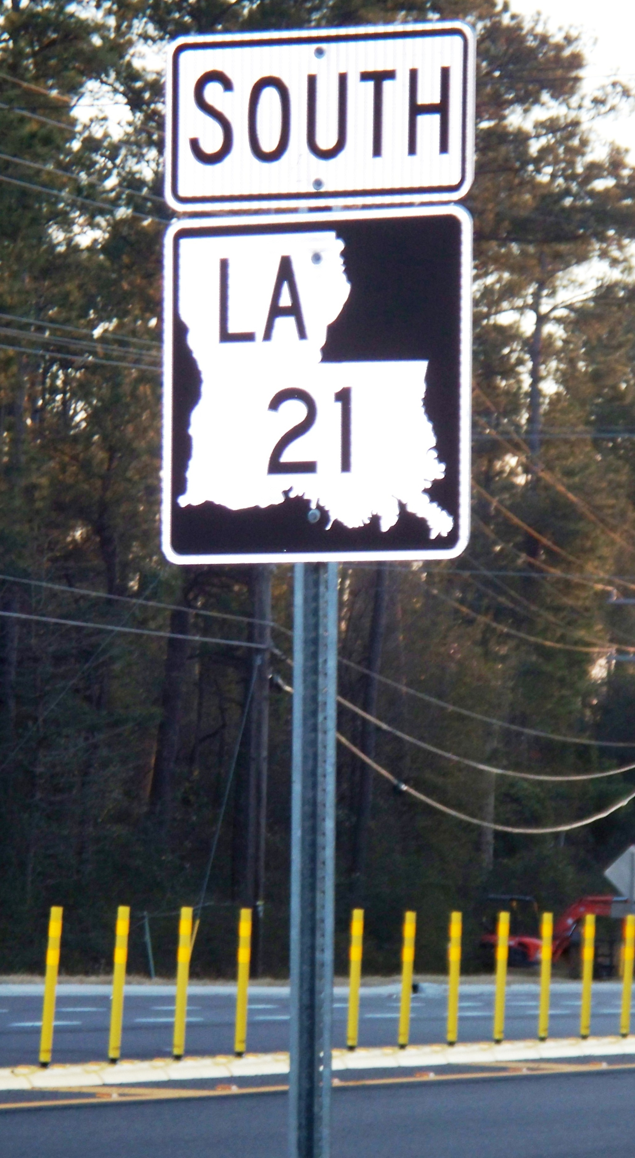
Louisiana sign for 1258
I'd like to give a huge THANKS! for making the LA 1258 shield. There's only one problem, and I would fix it myself if I knew how... the new shield design for Louisiana is different than the one in the picture. The one in the picture I posted on the article is the Louisiana DOTD's cheap way of making new signs, and if you look at the Louisiana Highways article, it shows a picture of the new one (with a white frame). Kind of like the old ones, just black instead of green.
I've attached a link to the photo that it would need to be changed to. My email is on my user page, so if you want to shoot me an email on how to create shields, it would be much appreciated!
Media:LA_21_with_border_20100114.JPG
Mcdonaat (talk) 21:01, 29 March 2012 (UTC)
- I have no objections to adding a border. I was actually going off a couple other examples. One being the LA 1258 sign in the article and the other image on List of numbered highways in Louisiana. But if we want a definitive answer, we need to find the DOTD's measured drawings of the signs. I've looked and looked but haven't found anything yet.
- As for making shields, we have a tutorial located at Wikipedia:WikiProject U.S. Roads/Shields task force/Tutorial. Currently, it's not very good, so I will take a little time today to fix that. :) –Fredddie™ 21:11, 29 March 2012 (UTC)
- Thanks for that! I can actually go to the DOTD offices, about a mile from where I live now, and talk to the sign department and get some specs. A project I wanted to do this summer was convert all of the current signs to the black and white versions, and see if it makes the articles a little more modern. Thanks for the shield, though, it helps out a good bit! Mcdonaat (talk) 02:37, 30 March 2012 (UTC)
- We were kinda waiting to change the markers over until reports are that the state is mostly switched. Unlike South Carolina or Oklahoma that resigned the state, I was under the impression that LaDOTD was changing them over by attrition. Imzadi 1979 → 02:45, 30 March 2012 (UTC)
Saint-Inglevert Airfield
I've reverted some of your good faith changes. Reasons given either in edit summaries or on the talk page. Mjroots (talk) 05:45, 4 April 2012 (UTC)
Updates on new Louisiana shields
Playing around with Photoshop, the general idea for the Louisiana shields that are being produced are that the green AND white border are both the new white border. Looking at the plain black signs, the new white and black bordered signs, and the green ones, it seems that both the green and white border pieces are combined. The rest of the shield is correct for the black sign you posted. I want to check with other people in the Louisiana group and see if something can be worked out where the new signs can be converted as the entire route gets converted to black and white signs. Might create a staggered effect, but if someone clicks over to see the green signs, and all the route has are black and white signs, then they might get confused.
By the way, can you post the instructions on the sign generator on my talk page? I think you posted the information on your page, then it got deleted. If anything, I can start producing signs for the routes that I know are fully converted. It might be best just to plug all of the shields into a generator, and convert them all at once. Too bad there's not a tool to do every sign at once! I think Louisiana has about 2800 numbered highways, if I'm not mistaken, so this could be quite the task!
Let me know what you want to do on my talk page, and I can contact the LaDOTD if you want me to for exact sign specs. If not, I can always run down the street and measure the signs myself. Mcdonaat (talk) 07:13, 13 April 2012 (UTC)
- (talk page stalker)There's a bot over on Commons that will generate whole lists of SVG graphics. The guy who runs it isn't always the most available, and you have to make up the template first, but he can do large quantities of marker graphics with the bot in an afternoon once he runs it. The request page is at commons:User:Highway Route Marker Bot/Requests. As for staggering the role out, it could be done, but the behind the scenes coding might get a little messy; I kinda prefer switching everything at once. Imzadi 1979 → 07:20, 13 April 2012 (UTC)
- Okay, thanks! I would have to learn how to make a template, and that could get messy, so I might need a small tutorial for that. Mcdonaat (talk) 07:54, 13 April 2012 (UTC)
Your HighBeam account is ready!
Good news! You now have access to 80 million articles in 6500 publications through HighBeam Research. Here's what you need to know:
- Your account activation code has been emailed to your Wikipedia email address.
- Only 407 of 444 codes were successfully delivered; most failed because email was simply not set up (You can set it in Special:Preferences).
- If you did not receive a code but were on the approved list, add your name to this section and we'll try again.
- The 1-year, free period begins when you enter the code.
- To activate your account: 1) Go to http://www.highbeam.com/prof1; 2) You’ll see the first page of a two-page registration. 3) Put in an email address and set up a password. (Use a different email address if you signed up for a free trial previously); 4) Click “Continue” to reach the second page of registration; 5) Input your basic information; 6) Input the activation code; 7) Click “Finish”. Note that the activation codes are one-time use only and are case-sensitive.
- If you need assistance, email "help at highbeam dot com", and include "HighBeam/Wikipedia" in the subject line. Or go to WP:HighBeam/Support, or ask User:Ocaasi. Please, per HighBeam's request, do not call the toll-free number for assistance with registration.
- A quick reminder about using the account: 1) try it out; 2) provide original citation information, in addition to linking to a HighBeam article; 3) avoid bare links to non-free HighBeam pages; 4) note "(subscription required)" in the citation, where appropriate
- HighBeam would love to hear feedback at WP:HighBeam/Experiences
- Show off your HighBeam access by placing {{User:Ocaasi/highbeam_userbox}} on your userpage
- When the 1-year period is up, check applications page to see if renewal is possible. We hope it will be.
Thanks for helping make Wikipedia better. Enjoy your research! Cheers, Ocaasi t | c 20:42, 13 April 2012 (UTC)
Talk:List of highways numbered 112S
Why did you remove {{WikiProject U.S. Roads}} from the page? Allen (Morriswa) (talk) 23:22, 18 April 2012 (UTC)
- Because it's not in the scope of WP:USRD. –Fredddie™ 00:06, 19 April 2012 (UTC)
- What do you mean, it's not in the scope of the WikiProject? Are there any other templates for assessment that should be put on the page? What about one for Wikipedia:WikiProject U.S. Streets? Allen (Morriswa) (talk) 02:15, 26 April 2012 (UTC)
Georgia State Route 401
Why are you removing Georgia State Route 401 from Georgia State Route 2's page? Yes, I know it is unsigned. However, if you look at countless other Georgia highway/U.S. highway/Interstate highway articles, you will see links to the unsigned Georgia State routes. Should we not add the links? Should they be removed? If this is the case, can some kind of notice be put on the appropriate pages of the WikiProject telling editors to not use them (and to remove current ones)? Allen (Morriswa) (talk) 02:12, 26 April 2012 (UTC)
- (talk page stalker) If SR 401 redirects to I-75, and you're already linking to I-75 there, the link is redundant and unneeded. My philosophy sometimes is like this: if I'm updating something that lies in a sea of mediocrity, I don't need to make my edits match the other crappy articles. Instead, the other crappy articles should be updated to match what I just improved. Imzadi 1979 → 03:13, 26 April 2012 (UTC)
USRD WikiProject Newsletter, Spring 2012
| ||
| Volume 5, Issue 2 • Spring 2012 • About the Newsletter | ||
|
|
|
| Archives • Newsroom • Full Issue • Shortcut: WP:USRD/NEWS | ||
- —Imzadi 1979 → 00:09, 1 May 2012 (UTC)
Here's what we're looking at
The whole sign is 48x48. Height between the top of LA and the top of the sign is going to be 4.75. The top of the Louisiana shape itself is halfway, so 2.375. The height of the letters is 12, the same height as they are now. The height of the number is 14. — Preceding unsigned comment added by Mcdonaat (talk • contribs) 23:31, 16 May 2012 (UTC)
- Is it 2.375 all the way around the state shape? –Fredddie™ 23:36, 16 May 2012 (UTC)
- Yep! Even along the bottom edge. I can scan a photo if it helps Mcdonaat (talk) 23:38, 16 May 2012 (UTC)
- That shouldn't be necessary as I'm working on it now. One more thing, though; is there a measurement from the left border to LA, and what is it? –Fredddie™ 23:42, 16 May 2012 (UTC)
- Yep! Even along the bottom edge. I can scan a photo if it helps Mcdonaat (talk) 23:38, 16 May 2012 (UTC)
New Louisiana shield conversion
Actually, from examining the specs, and measuring out the dimensions on your Louisiana 1258 shield, that's the right dimensions. If you want, that can be used as a template to roll out the new signs. Good luck, and thanks for that shield! Mcdonaat (talk) 03:45, 26 May 2012 (UTC)
- When I made the LA 1258 shield, I went ahead and made Media:Louisiana 0000 template.svg. Nice to know we got it right :) –Fredddie™ 03:59, 26 May 2012 (UTC)
- It looks awesome! When can we start to see a deployment, or rollout, of the new shields? Mcdonaat (talk) 20:24, 28 May 2012 (UTC)
- I think we, as a project, were going to wait until they were more prevalent than the green and white shields. Is that the case now? –Fredddie™ 21:58, 28 May 2012 (UTC)
- It's the case, all new shields are black and white, the DOTD is replacing them left and right. All state routes numbered 1-100 are converted at least 80%, so I believe it's time. Mcdonaat (talk) 06:08, 30 May 2012 (UTC)
- OK. We should probably upload them to a new name as to keep the old green shields. Right now we use the nomenclature
File:Louisiana <number>.svg, so I'm thinkingLA Highway <number>.svgorLouisiana <number> black.svg. Whatever we use, it shouldn't say "new". One last thing about the specs, what do they say about number font? It might say something like 14B or 14C. –Fredddie™ 17:06, 30 May 2012 (UTC)- Any chance that the older shields can be renamed to
Louisiana <number> pre-2009.svg? That way, the new shields will automatically fit into the pages, and the old shields can be reserved for routes that are going to be deleted sometime this year.Mcdonaat (talk) 20:36, 30 May 2012 (UTC)- We can do that, but it's a pain in the ass to move every file as we'd have to move them one-by-one. As far as I know, there is no fast way to do it. It's far, far easier to upload the new shields to a new name and update our templates accordingly. –Fredddie™ 20:40, 30 May 2012 (UTC)
- It sounds like a good plan! I did notice, though, that the LA 1258 shield needs to be changed to LA 1263, the DOTD decided to update the highway number for that stretch. Confuses me, but oh well! We could do
Louisiana <number> (2009).svgfor a quicker way. Mcdonaat (talk) 20:52, 30 May 2012 (UTC)- That works for me! –Fredddie™ 21:43, 30 May 2012 (UTC)
- Do you have an idea on when the shields will be updated? Mcdonaat (talk) 04:19, 31 May 2012 (UTC)
- Patience :) I can make them in relatively short time, but I have to finalize them all one-by-one unless I can find a way to convert this Windows batch file I have into something that doesn't require Windows. In the meantime if you (or a talk page stalker) could compile a list of shields needed (1, 2, 3, ... list format) that can only expedite things. –Fredddie™ 05:04, 31 May 2012 (UTC)
- Do you have an idea on when the shields will be updated? Mcdonaat (talk) 04:19, 31 May 2012 (UTC)
- That works for me! –Fredddie™ 21:43, 30 May 2012 (UTC)
- It sounds like a good plan! I did notice, though, that the LA 1258 shield needs to be changed to LA 1263, the DOTD decided to update the highway number for that stretch. Confuses me, but oh well! We could do
- We can do that, but it's a pain in the ass to move every file as we'd have to move them one-by-one. As far as I know, there is no fast way to do it. It's far, far easier to upload the new shields to a new name and update our templates accordingly. –Fredddie™ 20:40, 30 May 2012 (UTC)
- Any chance that the older shields can be renamed to
- OK. We should probably upload them to a new name as to keep the old green shields. Right now we use the nomenclature
- It's the case, all new shields are black and white, the DOTD is replacing them left and right. All state routes numbered 1-100 are converted at least 80%, so I believe it's time. Mcdonaat (talk) 06:08, 30 May 2012 (UTC)
- I think we, as a project, were going to wait until they were more prevalent than the green and white shields. Is that the case now? –Fredddie™ 21:58, 28 May 2012 (UTC)
- It looks awesome! When can we start to see a deployment, or rollout, of the new shields? Mcdonaat (talk) 20:24, 28 May 2012 (UTC)
Shield List
The list of shields needed would be 1-199, 300-1299, and 3000-3286. Hope this helps!! Mcdonaat (talk) 02:45, 1 June 2012 (UTC)
JCT template: Australian roads
Hi Freddie, would you be able to help out with modifying {{jct}} to accomodate Australian roads? I've started a new section on the template's Talk page - Evad37 (talk) 20:03, 13 June 2012 (UTC)
Re: Template:AUS-WAint
{{Talkback}}
Louisiana sign template - pre 1950
Since you're the kind of person to turn to, I am requesting a new highway sign template. It's going to look like [[1]], black-and-white with the pelican. The numbers seem to be the same style as the 1920's US highway shield numbers, and the letters are the same too. The only tricky part, it seems, is designing the pelican. Also, is there any way that LA 413, 620, 426, and 983/984 can be rolled out as a green sign? I'm getting a list of the highways that have been deleted, and they can retain the green shield. It's going to be the current lot of highways, as Wikipedia shows under Current Highways on the Louisiana highway list, that need to be converted to green. Some highways have been removed, and I'm going to move them over to the Former Highways list. Let me know if you need any help!! Mcdonaat 03:47, 17 June 2012 (UTC)
- I'll see what I can do, but you're right, The pelican will be tricky. –Fredddie™ 21:02, 16 June 2012 (UTC)
- Thanks! I have someone working on the pelican, and I'll post the SVG file on my talk page when it's done. Good luck with it! Mcdonaat 03:47, 17 June 2012 (UTC)
- In that case it should be easy! Please make sure the pelican is freely licensed, otherwise we can't really use it. –Fredddie™ 04:05, 17 June 2012 (UTC)
- The person that was supposed to draw up the pelican never came through with it. If you click here, there is a photo of a Louisiana shield, albeit in PNG format. It's on a website; however, the sign is a government item, and would be (as Wikimedia Commons would happily say) public domain. The best thing I could see doing would be to take the sign and retrace over it, so it's a vector file. Good luck, and thank you!! Mcdonaat 22:05, 19 June 2012 (UTC)
- State government works may be gratis, but not libre. We need both! –Fredddie™ 22:14, 19 June 2012 (UTC)
- In the case of Michigan, I have the statement of an official at MDOT, the text of the Michigan Manual on Uniform Traffic Control Devices, and a formal opinion of the state attorney general (which has the force of law in the state unless overturned in a state court) that state that our highway markers are in the public domain. Sadly, you'd need something similar to one of those three to know for sure that the older design is PD. If you have a contact at the LaDOTD that can verify that the older signs are PD, or even release the design, then that verification/release can be logged in OTRS and we're in the clear. Imzadi 1979 → 22:35, 19 June 2012 (UTC)
- Thanks for that! I can work on getting a formal opinion done. I did notice that the Louisiana highway template has been changed to black-and-white, but I have come across a few old highway maps that need to be added as former, deleted routes. Is there any way I can grab that template and use it? If you have it, it might be quicker just to give you a list of the highways that need shields. Those would be: 1208-5 and 1208-6. Thanks!! Mcdonaat 01:27, 20 June 2012 (UTC)
- In the case of Michigan, I have the statement of an official at MDOT, the text of the Michigan Manual on Uniform Traffic Control Devices, and a formal opinion of the state attorney general (which has the force of law in the state unless overturned in a state court) that state that our highway markers are in the public domain. Sadly, you'd need something similar to one of those three to know for sure that the older design is PD. If you have a contact at the LaDOTD that can verify that the older signs are PD, or even release the design, then that verification/release can be logged in OTRS and we're in the clear. Imzadi 1979 → 22:35, 19 June 2012 (UTC)
- State government works may be gratis, but not libre. We need both! –Fredddie™ 22:14, 19 June 2012 (UTC)
- The person that was supposed to draw up the pelican never came through with it. If you click here, there is a photo of a Louisiana shield, albeit in PNG format. It's on a website; however, the sign is a government item, and would be (as Wikimedia Commons would happily say) public domain. The best thing I could see doing would be to take the sign and retrace over it, so it's a vector file. Good luck, and thank you!! Mcdonaat 22:05, 19 June 2012 (UTC)
- In that case it should be easy! Please make sure the pelican is freely licensed, otherwise we can't really use it. –Fredddie™ 04:05, 17 June 2012 (UTC)
- Thanks! I have someone working on the pelican, and I'll post the SVG file on my talk page when it's done. Good luck with it! Mcdonaat 03:47, 17 June 2012 (UTC)
Arkansas sign drawings
Hey, I asked AHTD for the sign plans you were asking about here, and they sent them via email. I can email the file to you if you like, but the main concern you had (the location of B and S for bannered routes) is actually not specified. The maintenance engineer said that the placing of those letters is at the signer's discretion (aka its just a free for all, not a huge surprise coming from these guys). If you have another idea for how I can get the file to you, let me know. Brandonrush Woo pig sooie 13:52, 18 June 2012 (UTC)
- I don't like giving out my email address out in the open like this, but you can email me, I'll reply, and then you can send me the files. –Fredddie™ 22:26, 18 June 2012 (UTC)
Post-1955 Louisiana shields
Found a few older highways that need to be added under the green-and-white markers! I've put a list below showing which highways need to be added. 950-X 950-1 950-2 950-3 950-4 950-5 950-6 950-7 950-8 950-9 950-10 950-11 950-12 950-13 950-14 950-15 950-16 950-17
Thanks a billion! Mcdonaat 23:28, 20 June 2012 (UTC)
- OK, OK. It's probably a good idea to crosspost that list to WP:USRD/S/R. –Fredddie™ 03:32, 21 June 2012 (UTC)
- I'm going to post the black-and-white shields on the Wikipedia pages as Louisiana_XXXX_2012. That way, older highways which have been deleted will still show the green-and-white shields. I'm just doing the ones around my area that have been changed 100%, and see how it goes! Mcdonaat 00:01, 22 June 2012 (UTC)
GAN: Iowa Highway 160
Hello, I have reviewed the Iowa Highway 160 article that you nominated for GA status and I am glad to say that the article will pass. I just need you to clarify one issue I have which can be found on the review page before I pass the article.--Dom497 (talk) 18:06, 26 June 2012 (UTC)
Your GA nomination of U.S. Route 18 in Iowa
After thoroughly reviewing this article, I have decided to put it on hold ![]() at this time. For comments, please click here. If you have any questions, please feel free to ask. Rp0211 (talk2me) 23:46, 28 June 2012 (UTC)
at this time. For comments, please click here. If you have any questions, please feel free to ask. Rp0211 (talk2me) 23:46, 28 June 2012 (UTC)
- All issues have been addressed, so I passed
 the article. Congratulations and keep up the good work you are doing! Rp0211 (talk2me) 01:08, 29 June 2012 (UTC)
needs-kml
[2] - interesting idea; if we could implement it, that could save us a lot of work... --Rschen7754 03:52, 8 July 2012 (UTC)
Road Infobox - older shields
I'm updating the bannered routes on a few U.S. highways, and since some were removed before certain U.S. shields were introduced, it seems right to change the shield to either a 1948 marker or 1961. However, I've run into a problem where the marker will not show on the page. Is there a workaround for this, other than the option to force a marker to show? Mcdonaat 02:05, 11 July 2012 (UTC)
- Do you have an example? –Fredddie™ 02:45, 11 July 2012 (UTC)
- Click on over to this link to see what I did, manually. I can't get the infobox to display it correctly, though. Mcdonaat 02:58, 11 July 2012 (UTC)
- OK, the template is looking for Media:US 165 Louisiana 1948.svg. The white squares that you see in
{{Jct}}are just for that. There was a time those white squares were called "oversized" for junctions. The state-name shields were used as reassurance markers. We do have a template that can make these. Media:US XX YYY 1948.svg. –Fredddie™ 03:09, 11 July 2012 (UTC)- Any idea on how large the state name should be? Just typing Louisiana spaces it out a good bit. Mcdonaat 03:27, 11 July 2012 (UTC)
 Uploaded –Fredddie™ 04:13, 11 July 2012 (UTC)
- Thanks a million!!! I should have a statement coming from the DOTD soon on the Louisiana diamond shields, and I can relay that to you as soon as I get it. The hardest part would be the pelican, but after that, it's smooth sailing. The routes will be normal like 204, weird like C-2080, strange like 472-D, and downright dumb, like 99 1/2. The 1/2 should be the hardest part of the numbering, since no other state that I know of used half routes. Mcdonaat 05:26, 11 July 2012 (UTC)
- Any idea on how large the state name should be? Just typing Louisiana spaces it out a good bit. Mcdonaat 03:27, 11 July 2012 (UTC)
- OK, the template is looking for Media:US 165 Louisiana 1948.svg. The white squares that you see in
- Click on over to this link to see what I did, manually. I can't get the infobox to display it correctly, though. Mcdonaat 02:58, 11 July 2012 (UTC)
I have found the holy grail
Browsing around on the Louisiana state library, and I've come across the holy grail of signs. It's got cutout US routes, cutout diamond Louisiana routes (with a black top, ironically enough), curves and detours, and old fashioned stop signs. Makes me want to jump back in time for a week, steal some, then bring em back. Mcdonaat 02:18, 13 July 2012 (UTC)
- Nice. However, I think we may have a copyright issue with that picture, so I've commented it out. –Fredddie™ 02:41, 13 July 2012 (UTC)
- It's retouched, but it had the Louisiana shields. Just for fun, though, I was sent a Louisiana shield, pre-1955, by someone who creates the signs for custom use. Mcdonaat 03:31, 13 July 2012 (UTC)
Thecatchernumbersevenjooooemauer
{{Talkback}} 22:43, 13 July 2012 (UTC)
Le pink dots...
Honestly, I have no clue at all why the dots are pink. I'm guessing it's to stand out against the white, without actually standing out in the photo to the casual viewer. Mcdonaat 04:21, 18 July 2012 (UTC)
- Compare to Media:US 90 Louisiana 1926.svg. It should be a black circle around the hole and the hole itself transparent. –Fredddie™ 22:31, 19 July 2012 (UTC)
I created these by taking {{OKint}} and doing a find/replace to change all instances of "Oklahoma" to the appropriate state. Is there anything else I need to be doing?
Also, not that it really matters much, but the reason the mounting holes/dots are pink on our 1926 US template is because Jake (who created it) sends it off to fabrication with a pink background, then instructs them to cut away all of the pink...creating a cutout shield with cutout mounting holes. —Scott5114↗ [EXACT CHANGE ONLY] 03:48, 22 July 2012 (UTC)
- I figured that's what it was, but it takes us 30 seconds to correct it. –Fredddie™ 03:57, 22 July 2012 (UTC)
List of Recreational Roads in Texas/FLC
![]() Hello. You have a new message at Wikipedia:Featured list candidates/List of Recreational Roads in Texas/archive1's talk page. - Awardgive, the editor with the msitaken name. 17:54, 13 August 2012 (UTC)
Hello. You have a new message at Wikipedia:Featured list candidates/List of Recreational Roads in Texas/archive1's talk page. - Awardgive, the editor with the msitaken name. 17:54, 13 August 2012 (UTC)
DYK for Interstate 80 in Iowa
| On 21 August 2012, Did you know? was updated with a fact from the article Interstate 80 in Iowa, which you created or substantially expanded. The fact was ... that about one-third of Iowa's population lives along the I-80 corridor? The nomination discussion and review may be seen at Template:Did you know nominations/Interstate 80 in Iowa. You are welcome to check how many hits the article got while on the front page (here's how, quick check) and it will be added to DYKSTATS if it got over 5,000. If you know of another interesting fact from a recently created article, then please suggest it on the Did you know? talk page. |
Graeme Bartlett (talk) 08:02, 21 August 2012 (UTC)
BLSR?
I noticed that you updated the "type" field on some road pages to read "BLSR". What does this mean? Is it short for "Business Loop State Route"? Or, is it something else? Thanks. Allen (Morriswa) (talk) 04:25, 24 August 2012 (UTC)
Florida State Road 249
Just a question; did you fix the CR 751 shield in my article on Florida State Road 249? If so, could you do the same thing for the List of county roads in Hamilton County, Florida? ----DanTD 22:25, 27 August 2012 (UTC)
Happy Birthday Fredddie


Jcttop question
Could you take a look at Template talk:Jcttop#Location hatnote without county? for me? Thanks. —Scott5114↗ [EXACT CHANGE ONLY] 08:33, 1 September 2012 (UTC)
USRD Summer 2012 Newsletter
| ||
| Volume 5, Issue 3 • Summer 2012 • About the Newsletter | ||
|
|
|
| Archives • Newsroom • Full Issue • Shortcut: WP:USRD/NEWS | ||
- —Imzadi 1979 → 22:55, 2 September 2012 (UTC)
List of Recreational Roads in Texas
Could you please finish your review of the article? This is holding the FLC from possibly advancing. Thank you for your review, - Awardgive, the editor with the msitaken name. 07:25, 3 September 2012 (UTC)
- Thanks. I have replied to your newest comments as well. - Awardgive, the editor with the msitaken name. 22:10, 5 September 2012 (UTC)
GA Review
I have reviewed Interstate 80 in Iowa at Talk:Interstate 80 in Iowa/GA1 and placed the nomination on hold pending the resolution of a few issues. --Philosopher Let us reason together. 17:10, 5 September 2012 (UTC)
- I've passed the article.
 Congratulations! --Philosopher Let us reason together. 07:16, 11 September 2012 (UTC)
I am working my sandbox of Intersate 49 in Missouri and am running into diffuculties with the links using the Jct template. Currently, the links that are made by the template have a comma and a space before the state name. Like so Interstate 49 Business (, Missouri). Any suggestions? Thanks--intelati/talk 19:25, 14 September 2012 (UTC)
- (talk page stalker)That's because business loop/spur articles are named by the city they serve. You'll need to add
|dab1=Neoshoto link to Interstate 49 Business (Neosho, Missouri) and the like. Imzadi 1979 → 20:05, 14 September 2012 (UTC)- Ahh, Thanks--intelati/talk 20:25, 14 September 2012 (UTC)
- Yep. The BL links should probably be refactored such that without the dab, it would link Interstate 49 Business (Missouri) instead of having that weird comma. Then we can make set index pages from there. –Fredddie™ 23:45, 14 September 2012 (UTC)
- Ahh, Thanks--intelati/talk 20:25, 14 September 2012 (UTC)
Can I annoy you again?
Could you look and see whether there's an existing jct class for Oklahoma business routes? If not, would you mind adding it? SH and OK both work on the regular routes so they should probably be SH-Bus and OK-Bus...at least, those are the two obvious ones that I tried, and neither worked. —Scott5114↗ [EXACT CHANGE ONLY] 06:57, 15 September 2012 (UTC)
- SH-Bus

 SH-3 Bus.
- OK-Bus
- SH-3 Bus.
When these look right, it works. –Fredddie™ 18:16, 15 September 2012 (UTC)
BGS signs
Actually, do you happen to own copies of BGS-style US route markers? Also, if you could create a shield for me, it's the Louisiana freeway design, aka what goes on the Interstate signs for state routes. 'Mcdonaat → 07:01, 20 September 2012 (UTC)
- The US route markers for BGSs are the same as what we use on here with one caveat; there is no black background. I really don't know what Louisiana does for state highways. I've seen pictures, but they're terribly inconsistent. –Fredddie™ 12:00, 20 September 2012 (UTC)
South Dakota Highway 100
Hey, I was wondering, since you're pretty close to Sioux Falls and a roadgeek, if you know anything about this planned loop around Sioux Falls to be named "South Dakota Highway 100". There's almost no information on the internet about it or even a page on Wikipedia even though it is one of Sioux Falls' most urgent projects. If you don't know anything about it, could you maybe direct me to somebody who would? Mauer (talk) 03:53, 9 October 2012 (UTC)
- I had not heard of it, but I found it.
- I also checked SDDOT's 5-year plan, and here is the list of projects in the Sioux Falls area. I didn't see anything labeled SD 100, but you may recognize the project. –Fredddie™ 12:17, 9 October 2012 (UTC)
 Thank you for the link. I also gave a little input on the Interstate 80 in Iowa A-Class review. --Mauer (talk) 23:51, 9 October 2012 (UTC)
Township wikilinks for I-29 in ND
Random question. Should we keep all these townships wikilinked in the exit list? They're all red and will probably remain so for a long time. –Mauer (talk) 01:29, 12 October 2012 (UTC)
- WP:NODEADLINE. I'd keep them. Slowly buy surely, the links will be filled in. I've been surprised in Iowa when links turn blue. It'll happen. –Fredddie™ 02:08, 12 October 2012 (UTC)
SC shields
Response posted on my talk page. Mapsax (talk) 07:02, 12 October 2012 (UTC) And again. Mapsax (talk) 12:49, 14 October 2012 (UTC)
M-1 ACR revisit
Can you drop by the ACR to field a query? Imzadi 1979 → 09:27, 22 October 2012 (UTC)
KML and WikiMiniAtlas
I have started adding KML to the Louisiana Highway pages. The Google and Bing links work fine, but the WikiMiniAtlas isn't there. What am I missing? Can you take a look at Louisiana Highway 23 for an example? Thanks. Britinvasion64 (talk) 17:59, 7 November 2012 (UTC)
- (talk page stalker)It shows up for me. Occasionally there are updates to the coding for either the WMA or the KML template, and the globe will go missing for a short period of time as things re-cache in the system. Imzadi 1979 → 19:30, 7 November 2012 (UTC)
- Would the globe disappear from all articles or just the latest KML additions? The WMA appears to be missing from just the ones I recently added - on Chrome at least. On Internet Explorer, I can see the atlas but the red-highlighted route is missing... Britinvasion64 (talk) 22:28, 7 November 2012 (UTC)
- I actually have no idea. Dschwen (talk · contribs) is the person who created WMA. He might have some better answers as to why it's not working as intended. –Fredddie™ 23:55, 7 November 2012 (UTC)
- Thanks. I'll drop him a line. Britinvasion64 (talk) 01:41, 8 November 2012 (UTC)
- For the record, when using Chrome, it seems that clearing your history makes the WMA globe appear on pages to which you have recently added KML. Problem apparently solved. Britinvasion64 (talk) 19:36, 12 November 2012 (UTC)
- Thanks. I'll drop him a line. Britinvasion64 (talk) 01:41, 8 November 2012 (UTC)
- I actually have no idea. Dschwen (talk · contribs) is the person who created WMA. He might have some better answers as to why it's not working as intended. –Fredddie™ 23:55, 7 November 2012 (UTC)
- Would the globe disappear from all articles or just the latest KML additions? The WMA appears to be missing from just the ones I recently added - on Chrome at least. On Internet Explorer, I can see the atlas but the red-highlighted route is missing... Britinvasion64 (talk) 22:28, 7 November 2012 (UTC)
Florida SR-CR 10A
Okay, I appreciate your ability to show the state and county road shields in my proposed article for Florida State Road 10A without using the old parameters, but I'd still like to know how you were able to do it. I went without it, and the CR shiled didn't show up at all. ---------User:DanTD (talk) 13:40, 16 November 2012 (UTC)
- It's simple; I created the missing file. It worked perfectly then. –Fredddie™ 14:56, 16 November 2012 (UTC)
- Ah, I see. Then again, you did this yesterday. There are quite a few others that are currently triggering the Category:Infobox road transclusions without route marker category, I'd like to see added. ---------User:DanTD (talk) 00:46, 17 November 2012 (UTC)
- I'll get to those in due time. I also check the recent changes page for Category:Infobox_road_temporary_tracking_category_1. I try to clear stuff out of the userspace if I see it and if it's easy. –Fredddie™ 05:24, 17 November 2012 (UTC)
- Ah, I see. Then again, you did this yesterday. There are quite a few others that are currently triggering the Category:Infobox road transclusions without route marker category, I'd like to see added. ---------User:DanTD (talk) 00:46, 17 November 2012 (UTC)
Triple Crown

Disambiguation link notification for December 5
Hi. Thank you for your recent edits. Wikipedia appreciates your help. We noticed though that when you edited Iowa Highway 46, you added links pointing to the disambiguation pages Bypass and Wastewater treatment plant (check to confirm | fix with Dab solver). Such links are almost always unintended, since a disambiguation page is merely a list of "Did you mean..." article titles. Read the FAQ • Join us at the DPL WikiProject.
It's OK to remove this message. Also, to stop receiving these messages, follow these opt-out instructions. Thanks, DPL bot (talk) 11:07, 5 December 2012 (UTC)
New Brunswick route marker
Hi Fredddie! It just happens that I already have the New Brunswick shield as an svg vector. Where would you like it put? (Or I can e-mail it to you so you can work with it and upload it yourself.) And do you want all 3 colors? Should I leave the 95 on or do you want it/them blank? → Michael J Ⓣ Ⓒ Ⓜ 07:26, 8 December 2012 (UTC)
- I have sent you an email with my email address. You can just send it as is. I can work with pretty much anything, but I just could not get the province's shape right. Regarding the numbers, should we use the FHWA fonts (like used on every US shield) or should we use Arial/Helvetica/sans-serif? If we use the latter, we may be able to get away with not saving the number to path. –Fredddie™ 18:03, 8 December 2012 (UTC)
North Central Iowa pics

Fredddie, I will be traipsing around north central Iowa in the near future and was wondering if there were any highways in particular that I could photograph that would help move one of your articles forward? Let me know if you are interested, I would probably take pics similar to the one at right unless you want something else. Cheers, Brandonrush Woo pig soooooooie! 21:38, 11 December 2012 (UTC)
- ALL OF THEM! In all seriousness, I can't think of an article that doesn't need pics of some sort, so thanks a bunch for offering. If you know of any funky landmarks along any particular route in your area, get a shot of it. –Fredddie™ 23:09, 11 December 2012 (UTC)
- Alright, I will see what I can do. I know we are planning a trip to Minneapolis too, I will offer to drive the back way ;) Brandonrush Woo pig soooooooie! 23:56, 17 December 2012 (UTC)
signs
first of all, I am very impressed with your work in the commons. Second of all, I am not sure how to get the bot to work to make signs. What I want are the cut-out missouri route signs, like the ones used on guide signs. any help on the bot would be appreciated, because he may make those signs for me Brycecordry (talk) 23:20, 11 December 2012 (UTC)
- Well, thank you. Do you have a picture of what you're thinking of?
- We also have a shield request page so more people can see it. It's been fairly quiet for a while now, but that doesn't mean nobody sees it. –Fredddie™ 23:31, 11 December 2012 (UTC)
Disambiguation link notification for December 21
Hi. Thank you for your recent edits. Wikipedia appreciates your help. We noticed though that when you edited Iowa Highway 330, you added a link pointing to the disambiguation page Expressway (check to confirm | fix with Dab solver). Such links are almost always unintended, since a disambiguation page is merely a list of "Did you mean..." article titles. Read the FAQ • Join us at the DPL WikiProject.
It's OK to remove this message. Also, to stop receiving these messages, follow these opt-out instructions. Thanks, DPL bot (talk) 11:43, 21 December 2012 (UTC)
signs
as shown on Archive, I asked for a sign. Did you forget about cut out missouri route signs. thanks Brycecordry (talk) 22:05, 27 December 2012 (UTC)
- I did not forget. However, I asked you what signs specifically you needed. I'm still waiting for a response. –Fredddie™ 23:43, 27 December 2012 (UTC)
- I said on Imzadi79's talk that I would like a one-digit, two-digit, and three-digit template for the regular routes, and a one-letter and two-letter template for the supplemental routes, along with the Series of font you use (B, C, D, E, EM, F, ) in the description or right here, whichever is more convenient Brycecordry (talk) 18:57, 28 December 2012 (UTC)
- I have to make the templates first. The same template can be used for 1-, 2-, and 3-digit routes, so there's no need to make separate templates; same for the supplemental markers. As for the fonts, Roadgeek Fonts are freely available on the Internet. –Fredddie™ 19:32, 28 December 2012 (UTC)
- Yes, but that does not tell me which ones to use for which number. I have RoadGeek 2005. Brycecordry (talk) 14:03, 29 December 2012 (UTC)
- I usually consult http://shields.aaroads.com/ to know what needs what. –Fredddie™ 23:47, 29 December 2012 (UTC)
- Yes, but that does not tell me which ones to use for which number. I have RoadGeek 2005. Brycecordry (talk) 14:03, 29 December 2012 (UTC)
- I have to make the templates first. The same template can be used for 1-, 2-, and 3-digit routes, so there's no need to make separate templates; same for the supplemental markers. As for the fonts, Roadgeek Fonts are freely available on the Internet. –Fredddie™ 19:32, 28 December 2012 (UTC)
- I said on Imzadi79's talk that I would like a one-digit, two-digit, and three-digit template for the regular routes, and a one-letter and two-letter template for the supplemental routes, along with the Series of font you use (B, C, D, E, EM, F, ) in the description or right here, whichever is more convenient Brycecordry (talk) 18:57, 28 December 2012 (UTC)
Talkback

Message added 01:55, 30 December 2012 (UTC). You can remove this notice at any time by removing the {{Talkback}} or {{Tb}} template.
FutureTrillionaire (talk) 01:55, 30 December 2012 (UTC)
China roads
Thank you very much for the suggestion. I am slowly becoming familiar with the Jct template and am slowly working on improving the Chinese expressway articles, particularly the infoboxes - I will also keep the Infobox road template in mind and add improvements to those as well. Heights(Want to talk?) 02:32, 30 December 2012 (UTC)
- Alright, thank you. Heights(Want to talk?) 02:38, 30 December 2012 (UTC)
- Hi, I'm working on the Template:Infobox road for Chinese expressways and I've hit a bit of a stumbling block. Just for some background:
- In the Chinese highway system, single-digit expressways and double-digit expressways are considered major, primary expressways, e.g. G5 or G20. Auxiliary expressways (similar to like the prefix 2 in an I-290 compared to I-90 in the US) are given the suffix 11, 12, 13 etc to make G1511, G1512, etc. These are simple and since no two different stretches of auxiliary highway have the same designation, there is no problem However, ring roads that form around cities around a major expressway are given the designation 01, for the first ring, 02 for the second ring, to form e.g. 1501, 1502, etc.. Only one city has two rings so far, so here's where the problem arises. Multiple ring expressways in different cities have the exact same route number, e.g. G1501 Shanghai Ring Expressway, G1501 Shenyang Ring Expressway, G1501 Xiamen Ring Expressway, etc. These are in three different cities, not connected at all (Shanghai, Shenyang, and Xiamen) respectively, so how would Template:Infobox road handle these? I don't see a dab parameter for the route number in the infobox (only previous_dab and next_dab for the prev/next links). If I add an arbitrary set of numbers to distinguish it, for example 1501-SHLE for Shanghai, 1501-SYLE for Shenyang, the route name appears correctly in the infobox but the prev/next links become G1501-SHLE Shanghai Ring Expressway instead of the intended G1501 Shanghai Ring Expressway, and G1501-SYLE Shenyang Ring Expressway instead of the intended G1501 Shenyang Ring Expressway, etc.
- I am basically stuck at this point at how to resolve this and am looking for some assistance before I go further.
- Any help would be appreciated. Thanks Heights(Want to talk?) 16:59, 30 December 2012 (UTC)
- I'm not sure if you mean "route sign" to be synonymous with the "shield," but I am assuming so. And no, the route signs are not the same for the different G1501 highways. The road signs (see pictures) have text corresponding to the name of the expressway under them (in Chinese), and the names are obviously different (Shanghai Ring, Shenyang Ring, Xiamen Ring, etc.).
-
 Shanghai's
 -
 Shenyang's
 -
 Xiamen's
 -
 a version with no text


- The same user also uploaded a version of the G1501 sign without any text, so one possible solution is just to change all of the road signs to a no-text version (although on the actual expressways themselves, the text is there so this would be less detailed/accurate). The no name icons are already used in the jct template, because the jct icons are so small, the text wouldn't be readable anyway.
- Another solution I've stumbled upon is to possibly assign arbitrary letters to each differing highway with same number, e.g. G1501-SHLE, G1501-SYLE, G1501-XMLE (the images are already named this way - the user attached four letters after the number), and modify the links page as well this way. (So instead of links appearing as G{{{route}}} name-of-expressway-here Expressway, there would have to be and etc. for every single route number.
- I've fiddled around with subtype, and it doesn't appear to work. According to the technical notes, the template uses a mask to standardize the input of subtype before passing it onto /country. What happens is anything unrecognized like subtype=Shanghai, subtype=Xiamen just becomes nothing. However, it doesn't seem to filter out translations, so the Chinese name still comes out fine. For example, if I set route=1501, subtype=Shanghai, I get the english name "Ring Expressway" (instead of the desired "Shanghai Ring Expressway") since Shanghai is filtered out by the mask; but I get the chinese translation 上海绕城高速公路, which contains the city Shanghai(上海) in it. I also don't get the correct shield as subtype is filtered out by the mask. Heights(Want to talk?) 04:07, 31 December 2012 (UTC)
- Alright, I've found a way to make it work, using name=, translation= and marker_image= to disambiguate. It seems to be the only way possible. For prev/next, since there is a dab, that also works. Heights(Want to talk?) 18:12, 31 December 2012 (UTC)
- I've fiddled around with subtype, and it doesn't appear to work. According to the technical notes, the template uses a mask to standardize the input of subtype before passing it onto /country. What happens is anything unrecognized like subtype=Shanghai, subtype=Xiamen just becomes nothing. However, it doesn't seem to filter out translations, so the Chinese name still comes out fine. For example, if I set route=1501, subtype=Shanghai, I get the english name "Ring Expressway" (instead of the desired "Shanghai Ring Expressway") since Shanghai is filtered out by the mask; but I get the chinese translation 上海绕城高速公路, which contains the city Shanghai(上海) in it. I also don't get the correct shield as subtype is filtered out by the mask. Heights(Want to talk?) 04:07, 31 December 2012 (UTC)