
User talk:Citynoise
Thanks for leaving me a note! Comments are arranged in reverse-chronological order.
Please create an outline for Sarygamysh Lake for list of lakes by area. --220.245.49.25 (talk) 05:32, 24 October 2015 (UTC)
MBTA Map[edit]
Your map of the MBTA has been standard on Wikipedia, as you can see by Massachusetts Bay Transportation Authority and ka:ბოსტონის მეტროპოლიტენი and the rest of the pages. But now there's some question about its license: Commons:Commons:Deletion_requests/File:MBTA_Boston_subway_map.png. Would you be willing to give us a clear license suitable for Wikipedia and Commons for this?--Prosfilaes (talk) 20:22, 26 February 2011 (UTC)
- Could you go Commons:Commons:Deletion_requests/File:MBTA_Boston_subway_map.png and state that you want it under a CC-BY-SA-3.0 with that attribution then? Just for formality's sake.--Prosfilaes (talk) 20:36, 27 February 2011 (UTC)
- Thanks!--Prosfilaes (talk) 22:36, 27 February 2011 (UTC)
How far away is the horizon graph[edit]
The description of how to calculate the distance to the horizon (http://en.wikipedia.org/wiki/File:How_far_away_is_the_horizon.png) is a bit unclear in my opinion. The sentence about the distance of the horizon increasing by the square root of x when ascending x units makes little to no sense when looking at the graph. Going from 2m to 200m you go from seeing 5km to 50km, but according to mentioned sentence an ascent of 198 meters would increase the view by 14 meters, or, if there is a confusion of m/km 14km, which still does not add up. The correct calculation would be distance seen in km equals the square root of altitude in meters times 12.7 (or d(mi)=√alt(ft)*1.5), or am I missing something here? (24.80.234.209 (talk) 00:00, 17 June 2010 (UTC))
- I think the confusion here is that the important difference between 2m and 200m is a factor of 100 -- the absolute difference of 198m is not what you use to calculate. So, with a factor of 100 difference between 2m and 200m, the square root of 100 is 10, so the distance to the horizon increases by a factor of 10 -- from 5km to 50km. Hope this makes sense -- let me know if you think I'm missing something. Thanks! Citynoise (talk) 19:06, 18 June 2010 (UTC)
Well done on the graph, it's a great way to communicate the same info in various units. Signed, an anonymous user looking at lights on the horizon 58.181.161.20 (talk) 12:53, 14 April 2012 (UTC)
Impossible.[edit]
I have added a Talk section. Basically your graph shows the function to have the same feet-per-5280-feet slope as its meter-per-1000-meter slope. That is impossible.MarkFilipak (talk) 21:48, 29 November 2014 (UTC)
- A trivial check with the formulas given in the article shows that the graph is perfectly correct, and there is no problem with units. After all, this graph shows ratios, not absolute measurements -- when the viewer's height above the horizon is changed, the new distance to the horizon will be the same regardless of the units. (For example, near the earth's surface, doubling h will make d increase by sqrt(2), regardless of how they're measured.) The slope of the line is not 1:5280 or 1:1000, but rather 1:sqrt(2) Citynoise (talk) 16:29, 1 December 2014 (UTC)
Black Percent Map[edit]
I think there is something wrong with the map: http://en.wikipedia.org/wiki/File:New_2000_black_percent.gif. One example is a >5% black population living in Baker County, Oregon (http://en.wikipedia.org/wiki/Baker_County,_Oregon). I think the graphic should be edited or removed. The map does seem more or less right but perhaps there is something going on with the legend? Not sure. Good luck and thanks for the good work. Astauthamer (talk) 22:06, 14 October 2009 (UTC)
Hello, and a thousand thanks for creating the above-mentioned graph. I think it wouldn't be a bad idea to provide source information (e.g. a book reference) for this image, considering that it presents some highly detailed information that may change in the future. hydrox (talk) 07:51, 24 July 2009 (UTC)
Thanks[edit]
Thank you for your contributions to Wikipedia. —Preceding unsigned comment added by Intovert2438 (talk • contribs) 21:13, 28 July 2008 (UTC)
Feel like helping?[edit]
Hey, I'm nearing completion of the Yavapai people article (it's in my sandbox right now), and would really like a map showing preconquest territory. A book I have has one, but I presume it's copyrighted. So, if you could either replicate it somehow, or even tell me an easy way to do that, it would be MUCH appreciated. Cheers! Murderbike 22:31, 30 June 2007 (UTC)
- Cool! I don't have access to the book anymore, but I'm gonna try to get a copy of it, and when I do, I'll scan it and send it to ya somehow. Thanks for the response! Murderbike 21:26, 10 July 2007 (UTC)
Major endorheic basins[edit]
The two maps Image:Ocean drainage.png and Image:Major endorheric basins.png are really great maps, I would like to have an image of the basin in Arabia in large resolution, or maybe the map in SVG.
I am building a theory that the story of Noah probably happened in that basin, that way it would make more sense! The basin would get filled up with 40 days of rain (in a way that Mesopotamia could never do) and building an Ark there is even more remarkable than on the shores of two great rivers. --DelftUser 14:48, 12 February 2007 (UTC)
It says this map is copyright 2006 with no sign whatsoever of CC-BY-2.0. Can you explain? gren グレン 01:58, 10 February 2007 (UTC)
- Ah, okay. You had put "MUCH larger version of this" which led me to believe it was the same exact map just larger. I was going to convert the TIFF to a reasonable size and upload it but I didn't think it was under a free license. I have updated the image page to hopefully make it more clear.
- Could you possibly upload a version where the key is actually readable? I can't even tell what the income levels are being represented. gren グレン 03:21, 10 February 2007 (UTC)
List of world's largest domes[edit]
Hello. I am pretty pissed by your amateurish changes. Who do think you are? Chainsaw citynoise? You cut out half of the contents and mutilated the other half. In case, you do not know, I am the one who devised and started the page, and believe me it took me quite some time to gather the material and order it in a sensible matter. So, you better make a careful case of what you are doing here, or otherwise I see no choice other than to revert your mutilations. Best wishes Gun Powder Ma 11:58, 26 January 2007 (UTC)
Added your name to the Cartographers's list[edit]
I've added your name to Wikipedia:Wikipedians/Cartographers. --DelftUser 20:08, 15 January 2007 (UTC)
Missed this heading the 1st time around[edit]

Non-Hispanic White Map Request[edit]
Citynoise, do you think a Non-Hispanic White population map would be more representative of the "White American" population? A vast majority of Hispanics identify as "White" for the census, so it might be good to tease out this group if you are going to have a "Hispanic" population map. Let me know what you think. --Bfraga 18:43, 23 July 2006 (UTC)
- Actually, I'm thinking a Non-Hispanic White map would be pretty easy to create. I do a lot of work with the census (particulary census 2000), and almost all figures given down to the "place" level include non-hispanic white as distinct (now, non-white hispanic would be much more difficult, as would non-hispanic black, etc) since it is quite clear that this statistic is useful for many purposes, including civil rights legislation. In 1990, when "Hispanic" was distinguished as an "ethnic group", they did something similary, albeit less widespread. In 1980, the first time "Hispanic" was used as a category, the non-hispanic white population was not disaggregated, making almost all of those figures extremely difficult to analyze, forcing a person to look at the breakdown of the self-reported race of those who marked "Hispanic", then subtracting those who mark "white". I'm not absolutely sure where you're getting tract data broken down by race (I'd actually like to know for my own research), but I'm thinking it's probably there. Who knows though, the race/ethnicity seperation can be extremely cumbersome for particular ethnic groups. --Bfraga 06:27, 26 July 2006 (UTC)
- EDIT: I just checked American FactFinder, and found that you can actually see the non-hispanic population broken down by race right down to the census tract level. See what you think. --Bfraga 06:33, 26 July 2006 (UTC)
That "Geolytics" package sounds interesting. Do you think Stanford has a partnership with the company as well?
In regards to the "White American" question, the reason for using non-hispanic white as an indication of "White" america is because for most civil rights purposes in order to designate a segment of the population which has historically been discriminated against as a "non-white" group. For example, when you use the map you currently have, Mexican-Americans are included with "Whites." This group, as an example, has been singled out in the southwest for decades as an inferior "ethnic" group (or even racial group, most famously in the 1930 census, where Mexican was a race along with White, Negro, Indian, Hindu, Korean, Japanese, and Chinese). This would seem to imply that some believed "White" to be a superior ethnic group. However, the census calls "White" a racial group. Although it is interesting to see how many "Hispanics" identify as "White", this is really beside the point of most uses of census data related to the Hispanic population. Indeed, something like 48% of Hispanics identify racially as "White", and about 42% identify racially as "Hispanic" by selecting "Other" as their racial group and then writing in a Hispanic national origin or pan-ethnic label. I guess in the end it's up to you. Most of the work done regarding modern demographics (post-1990 census) uses non-Hispanic White figures instead of "White" figures. My opinion is that it's misleading to say "White" without stating that it includes Hispanic whites, simply because that accounts for something like 6-7% of all of those who identify as White. Ah, long comment, I apologize. Let me know what you think. --Bfraga 06:57, 27 July 2006 (UTC)
STANDING OVATION[edit]
The map of Indian Stream is the prettiest thing EVER!! Great work. jengod 03:36, 15 July 2006 (UTC)
Gini graph[edit]
Nice picture! Thanks for the contribution. Afelton 23:41, 23 September 2005 (UTC)
How did you find/calculate the US Gini previous to 1967, when the US Census Bureau first published the stat? —Preceding unsigned comment added by 152.42.174.215 (talk) 19:24, 26 February 2008 (UTC)
- I used data from the World Bank. I have a copy of the raw data which I’m happy to share if you’d like, but since you didn’t sign your comment I can’t contact you.. alas! Citynoise (talk) 19:34, 26 February 2008 (UTC)
- Greetings, I am a PhD student at Arizona State University doing some research using Gini Coefficient data. I have yet to find a source for Gini coefficient data over time as you have displayed in your graph. Can you please send me the raw data you referred to in your prior post on my user talk page (BluePotato1)? BluePotato1 (talk) 18:32, 22 January 2009 (UTC)
Hi, Citynoise.
Like the two posters above I would also like to be able to play with portions of the raw data that you used to make this plot, but I hate to see you have to go out of your way to send this data out repeatedly every time someone requests it. I think you should upload it somewhere and put a link into the Wikipedia Gini Index page so that other people can access it. This plot is a really beautiful compilation and presentation of Gini data, and I'm sure that lots of people would love to play with the raw data (especially given the current prominence of the Occupy Wall Street movement), but either cannot figure out how to request it, or like me, are a little hesitant to ask a busy Wikipedia editor to take the time to send it out to them individually. Please consider making this raw data available to all Wikipedia readers in a very easy-to-access form. Thanks for considering my request.
130.39.161.116 (talk) 15:46, 2 November 2011 (UTC)
John Hogan
Instructor
LSU Dept. of Chemistry
jhogan1@lsu.edu
http://hogan.chem.lsu.edu
Kudos, and map request[edit]
Hello Citynoise. Saw your map of The Republic of Indian River. Excellent job! Minor suggestions: (1) could the lines of the British and American claims be overlaid, or placed on a separate mini-map, to give historical context. (2) Could a couple of present-day towns/villages be included, to give context for modern-day readers. These could include Colebrook (sp?) NH, something in VT and ME, and something in QC. Chartierville, La Patrie and maybe Lac Mégantic and Armstrong spring to mind. Are there any present-day villages actually in the Indian river area? Having driven through the area, all I remember is a state park (and a herd of moose in the road!).
Now, for the request. I have recently added map requests for the defunct Republic of Madawaska, that I think would be up your alley. I have found some historical maps showing the area, but as the Republic was never a formal entity, the area the so-called Republic covered is somewhat vague. Certainly it included present-day Edmundston NB, and Madawaska ME, and probably most or all of the Madawaska River basin. I have some historical maps of the area, if that would help, but am not much of a cartographer myself. Let me know if these would help, and I'll upload them into the Commons. Thanks, and feel free to contact me on my talk page. Esseh 21:50, 20 April 2007 (UTC)
Your maps[edit]
I am very impressed with your maps. Would you tell me the type of program you used to make them?
Image:Boston area income.gif listed for deletion[edit]
An image or media file that you uploaded or altered, Image:Boston area income.gif, has been listed at Wikipedia:Images and media for deletion. Please see the discussion to see why this is (you may have to search for the title of the image to find its entry), if you are interested in it not being deleted. Thank you. —Angr 18:00, 13 September 2007 (UTC) —Angr 18:00, 13 September 2007 (UTC)
That's an interesting map. Which meridian is it centered on? Eyeballing it, it looks to me likes it's a little east of 0°, but I could be mistaken. And what is the projection used? I'm also interested in where you got your data and how you made the map. Thanks. --Kbh3rdtalk 17:38, 15 September 2007 (UTC)
Fair use disputed for Image:Assemblage first cover.jpg[edit]

Thanks for uploading Image:Assemblage first cover.jpg. However, there is a concern that the rationale you have provided for using this image under "fair use" may be invalid. Please read the instructions at Wikipedia:Non-free content carefully, then go to the image description page and clarify why you think the image qualifies for fair use. Using one of the templates at Wikipedia:Fair use rationale guideline is an easy way to ensure that your image is in compliance with Wikipedia policy, but remember that you must complete the template. Do not simply insert a blank template on an image page.
If it is determined that the image does not qualify under fair use, it will be deleted within a couple of days according to our Criteria for speedy deletion. If you have any questions please ask them at the Media copyright questions page. Thank you.BetacommandBot 05:05, 16 September 2007 (UTC)
Image:Boston T undistorted.gif[edit]
I have tagged Image:Boston T undistorted.gif for deletion since it is a poorer quality version of your image Image:MBTA Boston subway map.png. Hope you don't mind. Dread Pirate Westley•Aargh 15:18, 17 September 2007 (UTC)
Income donut maps[edit]
Hi, I've noticed your income donut maps and was wondering if you could grant permission for use of your Detroit map. Thanks.--Loodog 01:03, 30 September 2007 (UTC)
Jefferson Territory map[edit]
Hi, thanks for the map. Is it supposed to go that far north? It has part of Washington territory. And why is there an exclamation point? --AW (talk) 21:22, 8 February 2008 (UTC)
- Cool, thanks. I think you went too far north though, it says "north to the south line of Nebraska and north line of Kansas" but you went a bit past that, into Nebraska. --AW (talk) 20:13, 9 February 2008 (UTC)
Here's what I think it should look like, following the directions in the Wikipedia article [1] --AW (talk) 20:18, 9 February 2008 (UTC)
![[1]](http://i3.photobucket.com/albums/y76/squidpants/Jefferson_territory_new.png)
Caspian Sea[edit]
Hi Citynoise,
The ocean article does say that "Geologically, an ocean is an area of oceanic crust covered by water. ... From this perspective, there are three oceans today: the World Ocean and the Caspian and Black Seas". The Aral Sea is a lake geologically because it is a continental depression filled with water, which is quite different from the Caspian, which is a remnant of the world ocean which got isolated when Africa collided with Eurasia. Its twin, the Black Sea, was not connected to the World Sea until 7000 (?) years ago (the connection, by the way, is over land), and over the past few million years the Mediterranean Sea was also sealed off at the Straights of Gibraltar a couple times. Sometimes people describe them as being giant lakes at those times, but I don't know if they mean this seriously, or if it's poetic license for a lay audience. (The Mediterranean is sometimes poetically called a lake today, and more often people have spoken of saline lakes on the ocean floor as the Mediterranean dried up.) Analogously, the Atlantic Ocean has been called the Great Lake, with Europe and America being on opposite shores. The Caspian is called an inland sea (ocean sea vs. inland sea), but almost never a "lake". If we take the definition of a lake being a body of water surrounded by land literally, then the world ocean would also be a lake, since it is bounded on all sides by land. (Mathematically/topologically, there is no difference between the world ocean and the Caspian.) Of course, that's not what people mean when they say that, but it does show how slippery definitions can be. It's kind of like arguing whether Pluto is a planet.
The geological definition is less ambiguous than most. I left the Caspian in the Lakes by Area article for comparison, or for those who want it to be a lake; maybe we could do something similar for the Lakes by Volume article? kwami (talk) 00:23, 10 February 2008 (UTC)
Very nice picture. :) The only problem I can see with it is that it is very hard to distinguish between stronger storms (Categories 3, 4 and 5 in the Saffir-Simpson Hurricane Scale) because they are all similar shades of red. In order to get around that, we developed a color scale for use in Wikipedia, and we have it on Template talk:Storm colour. Would you mind reuploading the pic using that scale, to see if it is easier to distinguish between different storm intensities? Titoxd(?!? - cool stuff) 19:34, 15 March 2008 (UTC)
Amazing picture indeed! With your permission, I will use it in my PhD thesis manuscript to illustrate the climatology of tropical cyclogenesis. Thanks a lot for this amazing work. Daelomin (talk) 15:09, 19 June 2008 (UTC)
I've seen your image of the Tropical Cyclones 1945-2006, indeed, an excellent image!
A little suggestion about it, is it possible to separate the cyclones tracks into several time periods, and cumulate them with different combination? I believe this can figure out the opposite characteristic of the EI Nino and La Nina effect.
How do you think? sckuok (talk) 03:08, 10 Aug 2008
- Citynoise, thank you so much for your permission!
- About the El Niño and La Niña cycles, it seems that there are no regular periods, and have some transition between these two effects. Therefore, may be can try to remark on some major effect years first and see what happen,
- Here is some information about this, hope that can help:
- Major El Niños events: 1790-93, 1828, 1876-78, 1891, 1925-26, 1982-83, and 1997-98.
- Major La Niña events: 1988-1989, 1995, and in 1999-2000, 2008.
- sckuok (talk) 03:46, 13 Aug 2008
Regarding Image:Ocean drainage.png[edit]
I noticed that this map misses some internal drainage areas in the plains provinces of Canada. They can be seen in this map. Would it be possible to update the map and add them in? Esn (talk) 05:26, 24 July 2008 (UTC)
Suicide Map[edit]
While it is common and accepted practice to exclude Alaska and Hawaii from statistical maps, I think that in this particular case they bear including, Alaska especially. As a former resident of Alaska, I can attest to the very real problem of suicide in that state, and anything people can do to brink public awareness of this fact to the forefront is important. —Preceding unsigned comment added by Walkeraj (talk • contribs) 16:14, 5 September 2008 (UTC)
Lake Eyre[edit]
Hi,
Your image Image:Eyre outline.gif is missing. kwami (talk) 23:54, 5 September 2008 (UTC)
Duplicate Image:Major endoheric basins.png[edit]
Hello, this is a message from an automated bot. A tag has been placed on Image:Major endoheric basins.png, by another Wikipedia user, requesting that it be speedily deleted from Wikipedia. The tag claims that it should be speedily deleted because Image:Major endoheric basins.png is a duplicate of an already existing article, category or image.
To contest the tagging and request that administrators wait before possibly deleting Image:Major endoheric basins.png, please affix the template {{hangon}} to the page, and put a note on its talk page. If the article has already been deleted, see the advice and instructions at WP:WMD. Feel free to contact the bot operator if you have any questions about this or any problems with this bot, bearing in mind that this bot is only informing you of the nomination for speedy deletion; it does not perform any nominations or deletions itself. To see the user who deleted the page, click here CSDWarnBot (talk) 16:13, 7 October 2008 (UTC)
File:Taymyr outline.gif listed for deletion[edit]
An image or media file that you uploaded or altered, File:Taymyr outline.gif, has been listed at Wikipedia:Images and media for deletion. Please see the discussion to see why this is (you may have to search for the title of the image to find its entry), if you are interested in it not being deleted. Thank you. Skier Dude (talk) 05:28, 22 December 2008 (UTC)
File:Khanka outline.gif listed for deletion[edit]
An image or media file that you uploaded or altered, File:Khanka outline.gif, has been listed at Wikipedia:Images and media for deletion. Please see the discussion to see why this is (you may have to search for the title of the image to find its entry), if you are interested in it not being deleted. Thank you. Skier Dude (talk) 04:07, 24 December 2008 (UTC)
File:Maracaibo outline.gif listed for deletion[edit]
An image or media file that you uploaded or altered, File:Maracaibo outline.gif, has been listed at Wikipedia:Images and media for deletion. Please see the discussion to see why this is (you may have to search for the title of the image to find its entry), if you are interested in it not being deleted. Thank you. Skier Dude (talk) 04:26, 24 December 2008 (UTC)
File:Qinghai outline.gif listed for deletion[edit]
An image or media file that you uploaded or altered, File:Qinghai outline.gif, has been listed at Wikipedia:Images and media for deletion. Please see the discussion to see why this is (you may have to search for the title of the image to find its entry), if you are interested in it not being deleted. Thank you. Skier Dude (talk) 06:16, 25 December 2008 (UTC)
File:Aral outline.gif listed for deletion[edit]
An image or media file that you uploaded or altered, File:Aral outline.gif, has been listed at Wikipedia:Images and media for deletion. Please see the discussion to see why this is (you may have to search for the title of the image to find its entry), if you are interested in it not being deleted. Thank you. Skier Dude (talk) 06:43, 29 December 2008 (UTC)
File:Eyre outline.gif listed for deletion[edit]
An image or media file that you uploaded or altered, File:Eyre outline.gif, has been listed at Wikipedia:Images and media for deletion. Please see the discussion to see why this is (you may have to search for the title of the image to find its entry), if you are interested in it not being deleted. Thank you. Skier Dude (talk) 08:24, 30 December 2008 (UTC)
File:Huron outline.gif listed for deletion[edit]
An image or media file that you uploaded or altered, File:Huron outline.gif, has been listed at Wikipedia:Images and media for deletion. Please see the discussion to see why this is (you may have to search for the title of the image to find its entry), if you are interested in it not being deleted. Thank you. Skier Dude (talk) 06:42, 31 December 2008 (UTC)
File:Kyoga outline.gif listed for deletion[edit]
An image or media file that you uploaded or altered, File:Kyoga outline.gif, has been listed at Wikipedia:Images and media for deletion. Please see the discussion to see why this is (you may have to search for the title of the image to find its entry), if you are interested in it not being deleted. Thank you. Skier Dude (talk) 07:15, 31 December 2008 (UTC)
File:Michigan outline.gif listed for deletion[edit]
An image or media file that you uploaded or altered, File:Michigan outline.gif, has been listed at Wikipedia:Images and media for deletion. Please see the discussion to see why this is (you may have to search for the title of the image to find its entry), if you are interested in it not being deleted. Thank you. Skier Dude (talk) 04:40, 1 January 2009 (UTC)
File:Scale outline.gif listed for deletion[edit]
An image or media file that you uploaded or altered, File:Scale outline.gif, has been listed at Wikipedia:Images and media for deletion. Please see the discussion to see why this is (you may have to search for the title of the image to find its entry), if you are interested in it not being deleted. Thank you. Skier Dude (talk) 04:09, 2 January 2009 (UTC)
File:Torrens outline.gif listed for deletion[edit]
An image or media file that you uploaded or altered, File:Torrens outline.gif, has been listed at Wikipedia:Images and media for deletion. Please see the discussion to see why this is (you may have to search for the title of the image to find its entry), if you are interested in it not being deleted. Thank you. Skier Dude (talk) 05:50, 3 January 2009 (UTC)
Regarding Image:Cascadia megacity map.png[edit]
Hello! I was reading through the Pacific Northwest article, and noticed this map. It's quite good. I don't personally have any skills when it comes to making any sort of maps, or any knoweldge of .png files, quite honestly. I was hoping I could none the less make a request (although, I am new here too, so I hope I don't over-step my social bounds... I was wondering if it would be possible to add Eugene to this, considering it has the third largest airport in the US Pac NW, as well as being Oregon's second largest city (depending on year, sure). It's also an educational hub of the Pac NW, and it's a fairly well known city. I hope it's not too much to ask, thanks for reading, I like a lot of what I've seen of your work. uoregonduckman (talk) 02:07, 24 May 2009 (PST) <-- The best time zone ;)
NowCommons: File:Earth elevation histogram 2.svg[edit]
File:Earth elevation histogram 2.svg is now available on Wikimedia Commons as Commons:File:Earth elevation histogram 2 (1).svg. This is a repository of free media that can be used on all Wikimedia wikis. The image will be deleted from Wikipedia, but this doesn't mean it can't be used anymore. You can embed an image uploaded to Commons like you would an image uploaded to Wikipedia, in this case: [[File:Earth elevation histogram 2 (1).svg]]. Note that this is an automated message to inform you about the move. This bot did not copy the image itself. --Erwin85Bot (talk) 02:53, 27 September 2009 (UTC)
.svg)
Data on American military history[edit]
Hi, I saw you had created the graph of the American military personnel as a percentage of the population over the years. Do you know of any reference where I can find those data in terms of raw numbers instead of as percentages? Thanks. Ken l lee (talk) 05:03, 28 September 2009 (UTC)
Thanks very much. I've sent you an email already. Ken l lee (talk) 14:13, 2 October 2009 (UTC)
Alliance of Small Island States Map[edit]
Hello this map on page; Alliance of Small Island States : http://en.wikipedia.org/wiki/File:AOSIS_members.png#file has a small mistake, highlighted, in dark green is Cyprus, when it is infact not a member of the association, Malta is however, and I believe you meant to highlight this one instead. Regards. JMW. —Preceding unsigned comment added by Jmw-2003 (talk • contribs) 22:25, 11 December 2009 (UTC)
Missing Lakes...[edit]
I just translated into Italian the list of lakes by area where you created the miniatures of the lakes on the list. Could you also make those of the few lakes missing? Thanks! :-)--Threecharlie (talk) 22:43, 30 March 2010 (UTC)
About File:Gini_since_WWII.svg[edit]
Hi! First of all, thanks for all of your contributions to Wikipedia, many of your maps are quite awesome and make a great addition to Wikipedia. As for the File, I'd like to give it a try of creating a graphic, as the current one is quite cluttered, could you please post, or send me the references for the data?
Thanks, and Regards, Sebastian 02:18, 8 April 2010 (UTC) —Preceding unsigned comment added by Tian2992 (talk • contribs)
File:Ocean drainage.png[edit]
Hi Citynoise. I added a description to your map and to the commons page of the map, hope thats ok? regards --W like wiki (talk) 01:06, 12 March 2011 (UTC)
Possibly unfree File:Sansan.png[edit]
A file that you uploaded or altered, File:Sansan.png, has been listed at Wikipedia:Possibly unfree files because its copyright status is unclear or disputed. If the file's copyright status cannot be verified, it may be deleted. You may find more information on the file description page. You are welcome to add comments to its entry at the discussion if you are interested in it not being deleted. Thank you. --Shizhao (talk) 12:06, 16 March 2011 (UTC)
Earth elevation-area graph[edit]
Thank you for your elegant Earth elevation-area graph. However, can you please point me to the source of the data you based the graph on. --Epipelagic (talk) 22:05, 26 April 2011 (UTC)
- Ah great. That's much appreciated. --Epipelagic (talk) 08:12, 27 April 2011 (UTC)
G77[edit]
Hi, would you be able to update this so Algeria wil have held the chair thrice, Yemen once, and Argentina once? Therequiembellishere (talk) 04:21, 1 September 2011 (UTC)
- Thanks! Therequiembellishere (talk) 16:06, 2 September 2011 (UTC)
Gini since WWII.svg[edit]
Citynoise,
Any chance you could upload and link to the raw data you acquired and used to create this plot on the Wikipedia articles which use this plot? I don't understand the nuts and bolts of Wikipedia well enough to know how many hoops you have to jump through to get this done rather than just emailing the data to everyone who requests it individually. I'd like to know whether or not you can do this fairly easily, however, and if you are willing to do so, or if you have too many irons in the fire currently to be bothered with it. I posted this request previously on another discussion, but you probably didn't read it as there has not been any other recent activity on that discussion. Thanks for considering this request.
130.39.161.116 (talk) 00:21, 26 November 2011 (UTC)
-John Hogan
jhogan1@lsu.edu
US military personnel and expenditures[edit]
I love your graph of US military personnel and expenditures. I would like to use this graph (or a modified version of it) in a book that I am writing on the Cold War. I would like your permission to do this.
I also wonder if you could provide me with the raw graph or spreadsheet, and also your sources for the data. For the purposes of the book, I only need the expenditures portion of the graph, and since the book is going to be black on white only, the colors in this chart will obscure the needed values.
All proper credits will be applied to any data that is used.
Thanks,
Frugalberry (talk) 12:36, 23 February 2012 (UTC)
File:US Public debt per GDP 1791-2006.svg listed for deletion[edit]
A file that you uploaded or altered, File:US Public debt per GDP 1791-2006.svg, has been listed at Wikipedia:Files for deletion. Please see the discussion to see why this is (you may have to search for the title of the image to find its entry), if you are interested in it not being deleted. Thank you. MGA73 (talk) 15:46, 1 June 2012 (UTC)
Thanks for your addition of the above graphic to Long and short scales, which is very welcome. Next time you locate your magic paintbrush, I believe we have now identified / allocated all the light grey areas - i.e. allocated the missing areas - see article or talk page for details. Thanks, 78.105.123.238 (talk) 23:31, 17 June 2012 (UTC)
- A double-check - Following your response to my above comment, I was able to allocate the grey countries you highlighted as exceptions. Were you then able to re-re-issue your graphic? BRgrds, Ian 78.105.123.238 (talk) 23:36, 24 June 2012 (UTC)
- The following [2] has been posted on the LASS talk page. Thanks, Itc editor (talk) 16:20, 29 December 2012 (UTC)
Sources for File:Gini since WWII.gif[edit]
Could you tell me what were your sources, or better - add that information to the graph? Thanks! --Piotr Konieczny aka Prokonsul Piotrus| reply here 21:06, 15 January 2013 (UTC)
Updated maps for "Gender differences in suicide[edit]
Hello! I am working on updating the Wikipedia page "Gender differences in suicide". I think the maps that you've included provide some good data for the article, however they are a little out of date. I went to the website linked through the pictures (radicalcartography), and saw that you'd made some new maps using more recent data. Would it be possible for you to upload the new pictures so that the article accurately reflects current trends? I'm fairly new to Wikipedia, so I'm unsure how/if I can do this myself. Thanks for any help you can provide! CoeA (talk) 14:33, 17 April 2013 (UTC)
World homosexuality laws map[edit]
Hello. I see that you are interested in maps. I was wondering if you would be interested in modifying this map [3] (or creating a new map), so that propaganda laws and anti-discrimination laws can also be included such as this map [4]. The green colour for de jure penalty that is de facto not enforced is also problematic. Such a map would be very useful and could be used in non-English wikipedia's as well. Cavann (talk) 01:19, 24 May 2013 (UTC)
![[3]](https://commons.wikimedia.org/wiki/File:World_homosexuality_laws.svg)
File:Mweru outline.gif listed for deletion[edit]
A file that you uploaded or altered, File:Mweru outline.gif, has been listed at Wikipedia:Files for deletion. Please see the discussion to see why this is (you may have to search for the title of the image to find its entry), if you are interested in it not being deleted. Thank you. Sfan00 IMG (talk) 19:07, 13 July 2013 (UTC)
Lightning Map of Colorado/Utah?[edit]
I'm interested in a large size version of your worldwide lightning strikes map. My interest is in the Colorado/Utah area, as I'd like to look for patterns in the mountain topography for the Colorado Outward Bound School. Is that something I could get from you?
Asteel1981 (talk) 01:04, 16 August 2013 (UTC)
File:Clarendon WANTED kerned.png listed for deletion[edit]
A file that you uploaded or altered, File:Clarendon WANTED kerned.png, has been listed at Wikipedia:Files for deletion. Please see the discussion to see why it has been listed (you may have to search for the title of the image to find its entry). Feel free to add your opinion on the matter below the nomination. Thank you. Kelly hi! 22:44, 2 December 2013 (UTC)
Notification of automated file description generation[edit]
Your upload of File:Boston annexation landfill.gif or contribution to its description is noted, and thanks (even if belatedly) for your contribution. In order to help make better use of the media, an attempt has been made by an automated process to identify and add certain information to the media's description page.
This notification is placed on your talk page because a bot has identified you either as the uploader of the file, or as a contributor to its metadata. It would be appreciated if you could carefully review the information the bot added. To opt out of these notifications, please follow the instructions here. Thanks! Message delivered by Theo's Little Bot (opt-out) 14:03, 19 February 2014 (UTC)
Endorheic map sources?[edit]
Can you give the references you used for your endorheic basins map? I'd like to use them in an article submission to a journal. Msinvb (talk) 19:27, 16 May 2014 (UTC)
- Hi, Msinvb, sure thing! The data I used were from the USGS -- the HYDRO1k dataset. There is a new version of this data available, but I haven't checked for any changes. Hope this helps! Citynoise (talk) 11:25, 18 May 2014 (UTC)
Disambiguation link notification for January 3[edit]
Hi. Thank you for your recent edits. Wikipedia appreciates your help. We noticed though that when you edited Neanderthal, you added a link pointing to the disambiguation page William King. Such links are almost always unintended, since a disambiguation page is merely a list of "Did you mean..." article titles. Read the FAQ • Join us at the DPL WikiProject.
It's OK to remove this message. Also, to stop receiving these messages, follow these opt-out instructions. Thanks, DPL bot (talk) 11:25, 3 January 2015 (UTC)
[edit]
Niece24.11.170.191 (talk) 12:51, 17 January 2015 (UTC)
- I came to your talk page to point out the same thing. Could you fix it please? [apparently unsigned]
- Ditto. Niece not Neice. Nice graphic otherwise. SurplusGadgets (talk) 20:09, 31 August 2015 (UTC)
Difference between superior and superscript letters[edit]
Hello. I'm writing you because you created File:Subscript superscript examples.png so you are probably interested in typography. Do you agree that the style of superior letters is distinct from superscript? Thanks in advance. Ain92 (talk) 13:58, 24 February 2015 (UTC)
About Gini index graph[edit]
Hi and thanks for your work. I don't find the whole data about gini index in the world bank page. Could you write the webpage you got the data? Could write it in this page so everybody can see it? Thanks again. Castingdiego (talk) 13:07, 27 March 2015 (UTC)
Global user pages[edit]
I came by way of c:User:Citynoise - m:global user pages were recently introduced and might be of interest to you. Bazj (talk) 09:17, 9 July 2015 (UTC)
List of Mayors of New Haven, CT[edit]
Hello - thank you for adding details to the entry on New Haven Mayors page for Lucien Wells Sperry. He was my first cousin, six times removed. I have just come to learn of his suicide and the scandal that preceeded it, but it appears to be very difficult to find resources for full information. Can you tell me where you got the information for your edit: "committed suicide after embezzling trust funds; died $50,000 in debt"? The only reference I have been able to turn up is from a short notice in a newspaper in California. I also understand that Lucien's troubles began about a decade earlier as he was caught up in the Noyes Insurance Investigation, but wikipedia has nothing on this apparently. Thank you for any additional light you may be able to shed! SheilaMc7 (talk) 13:41, 17 July 2015 (UTC)
Kudos[edit]
Exciting primary scholarly work, and related work here. Would echo an earlier request, and note that a way in which unverifiable information is routinely inserted into WP articles—via visual information that is unsourced, and so essentially editor OR. Anything you can do to set a scholarly standard here, akin to what you are doing daily at work, would be greatly appreciated. Best wishes in building your portfolio toward your promotion. Le Prof. 71.201.62.200 (talk) 04:29, 18 August 2015 (UTC)
This is a fantastic map (one of my favorite graphics on Wikipedia, actually), but it's now a bit outdated. The first thing I noticed was that it does not reflect the new alignment of the Vermonter. Also, the density is using 2000 census data. If you get the chance, it would be nice to have an updated version of this graphic.
Obviously, you can't update it every time something on the map no longer exactly reflects facts on the ground, but with newer census data available and a significant realignment of (at least) one piece of the transportation infrastructure shown on the map, perhaps now is a good time?
Thank you for enriching Wikipedia with excellent graphics such as this one.
Dave314159 (talk) 17:49, 28 August 2015 (UTC)
Please create an outline for Sarygamysh Lake for list of lakes by area. --220.245.49.25 (talk) 05:32, 24 October 2015 (UTC)
Hi,
You appear to be eligible to vote in the current Arbitration Committee election. The Arbitration Committee is the panel of editors responsible for conducting the Wikipedia arbitration process. It has the authority to enact binding solutions for disputes between editors, primarily related to serious behavioural issues that the community has been unable to resolve. This includes the ability to impose site bans, topic bans, editing restrictions, and other measures needed to maintain our editing environment. The arbitration policy describes the Committee's roles and responsibilities in greater detail. If you wish to participate, you are welcome to review the candidates' statements and submit your choices on the voting page. For the Election committee, MediaWiki message delivery (talk) 13:07, 23 November 2015 (UTC)
Hi,
You appear to be eligible to vote in the current Arbitration Committee election. The Arbitration Committee is the panel of editors responsible for conducting the Wikipedia arbitration process. It has the authority to enact binding solutions for disputes between editors, primarily related to serious behavioural issues that the community has been unable to resolve. This includes the ability to impose site bans, topic bans, editing restrictions, and other measures needed to maintain our editing environment. The arbitration policy describes the Committee's roles and responsibilities in greater detail. If you wish to participate, you are welcome to review the candidates' statements and submit your choices on the voting page. For the Election committee, MediaWiki message delivery (talk) 13:33, 23 November 2015 (UTC)
File:Sub super num dem.png listed for discussion[edit]

A file that you uploaded or altered, File:Sub super num dem.png, has been listed at Wikipedia:Files for discussion. Please see the discussion to see why it has been listed (you may have to search for the title of the image to find its entry). Feel free to add your opinion on the matter below the nomination. Thank you. Jc86035 (talk • contribs) Use {{re|Jc86035}} to reply to me 09:33, 24 August 2016 (UTC)
Request text correction on Republic of Indian Stream map[edit]
I really like your map of the Republic of Indian Stream (https://commons.wikimedia.org/wiki/File:Indian_stream_map.png), and I have added a lot of information to the article.
Could you please make a correction to some text on the map? This image needs to have British Province of Quebec changed to British Colony of Lower Canada or simply, Lower Canada. The "British Province of Quebec" ended in 1791, when its eastern part became "Lower Canada." So during the existence of the Republic of Indian Stream, the area to the north was Lower Canada.
It would be greatly appreciated! Jeff in CA (talk) 17:03, 6 September 2016 (UTC)
- Thank you! Jeff in CA (talk) 01:34, 7 September 2016 (UTC)
ArbCom Elections 2016: Voting now open![edit]
Hello, Citynoise. Voting in the 2016 Arbitration Committee elections is open from Monday, 00:00, 21 November through Sunday, 23:59, 4 December to all unblocked users who have registered an account before Wednesday, 00:00, 28 October 2016 and have made at least 150 mainspace edits before Sunday, 00:00, 1 November 2016.
The Arbitration Committee is the panel of editors responsible for conducting the Wikipedia arbitration process. It has the authority to impose binding solutions to disputes between editors, primarily for serious conduct disputes the community has been unable to resolve. This includes the authority to impose site bans, topic bans, editing restrictions, and other measures needed to maintain our editing environment. The arbitration policy describes the Committee's roles and responsibilities in greater detail.
If you wish to participate in the 2016 election, please review the candidates' statements and submit your choices on the voting page. MediaWiki message delivery (talk) 22:08, 21 November 2016 (UTC)
ArbCom 2017 election voter message[edit]
Hello, Citynoise. Voting in the 2017 Arbitration Committee elections is now open until 23.59 on Sunday, 10 December. All users who registered an account before Saturday, 28 October 2017, made at least 150 mainspace edits before Wednesday, 1 November 2017 and are not currently blocked are eligible to vote. Users with alternate accounts may only vote once.
The Arbitration Committee is the panel of editors responsible for conducting the Wikipedia arbitration process. It has the authority to impose binding solutions to disputes between editors, primarily for serious conduct disputes the community has been unable to resolve. This includes the authority to impose site bans, topic bans, editing restrictions, and other measures needed to maintain our editing environment. The arbitration policy describes the Committee's roles and responsibilities in greater detail.
If you wish to participate in the 2017 election, please review the candidates and submit your choices on the voting page. MediaWiki message delivery (talk) 18:42, 3 December 2017 (UTC)
ArbCom 2018 election voter message[edit]
Hello, Citynoise. Voting in the 2018 Arbitration Committee elections is now open until 23.59 on Sunday, 3 December. All users who registered an account before Sunday, 28 October 2018, made at least 150 mainspace edits before Thursday, 1 November 2018 and are not currently blocked are eligible to vote. Users with alternate accounts may only vote once.
The Arbitration Committee is the panel of editors responsible for conducting the Wikipedia arbitration process. It has the authority to impose binding solutions to disputes between editors, primarily for serious conduct disputes the community has been unable to resolve. This includes the authority to impose site bans, topic bans, editing restrictions, and other measures needed to maintain our editing environment. The arbitration policy describes the Committee's roles and responsibilities in greater detail.
If you wish to participate in the 2018 election, please review the candidates and submit your choices on the voting page. MediaWiki message delivery (talk) 18:42, 19 November 2018 (UTC)
US military personnel and expenditures.png[edit]
Your graph on US mil pers and exp is fantastic. I would like to use it in a paper but wanted to see if you might still have the sources you used to construct the image. Thanks for any help! — Preceding unsigned comment added by Grunt951 (talk • contribs) 20:22, 7 April 2019 (UTC)
Greek Code Pages[edit]
The diacritics in the links looked fine to me before this patch:
https://en.wikipedia.org/w/index.php?title=ISO/IEC_8859-7&diff=924361168&oldid=891882949
This was on Chrome on Linux. Also seemed ok on Chrome on an Android phone. What browser are you using? Spitzak (talk) 20:47, 3 November 2019 (UTC)
- Bizarre. The previous edit also looks fine on my machine using Chrome and IE. Not sure what the issue might be, is there a way to bump this to the appropriate keeper of the chset code? Or should we just revert and hope Firefox (on Windows 8) sorts itself out eventually? Either is fine with me. (I hadn't thought to try other browsers before making the edits!) Citynoise (talk) 20:43, 4 November 2019 (UTC)
ArbCom 2019 election voter message[edit]
Questions regarding American Indian reservations US map[edit]
I've made some changes to the Commons page for File:Indian reservations.gif, the exact changes can be found here. I believe they are correct, but since, as per your user page and this you appear to be the author of the file, I wanted to check with you to confirm that they are accurate.
Secondly, the file is currently listed on Commons as being licensed under CC BY 2.0, while the Radical Cartography contact page list that the site's contents are licensed under CC BY-NC-SA 3.0. Can you clarify what licence File:Indian reservations.gif is under?
Finally, would you be willing to upload a larger version of the file to Commons akin to found on the poster? Theoretically, I could do so by cropping the poster's image and removing the text, but I think, overall, it would best if you uploaded the original, if that is possible. Many sincere thanks, The Editor's Apprentice (talk) 15:41, 27 January 2020 (UTC)
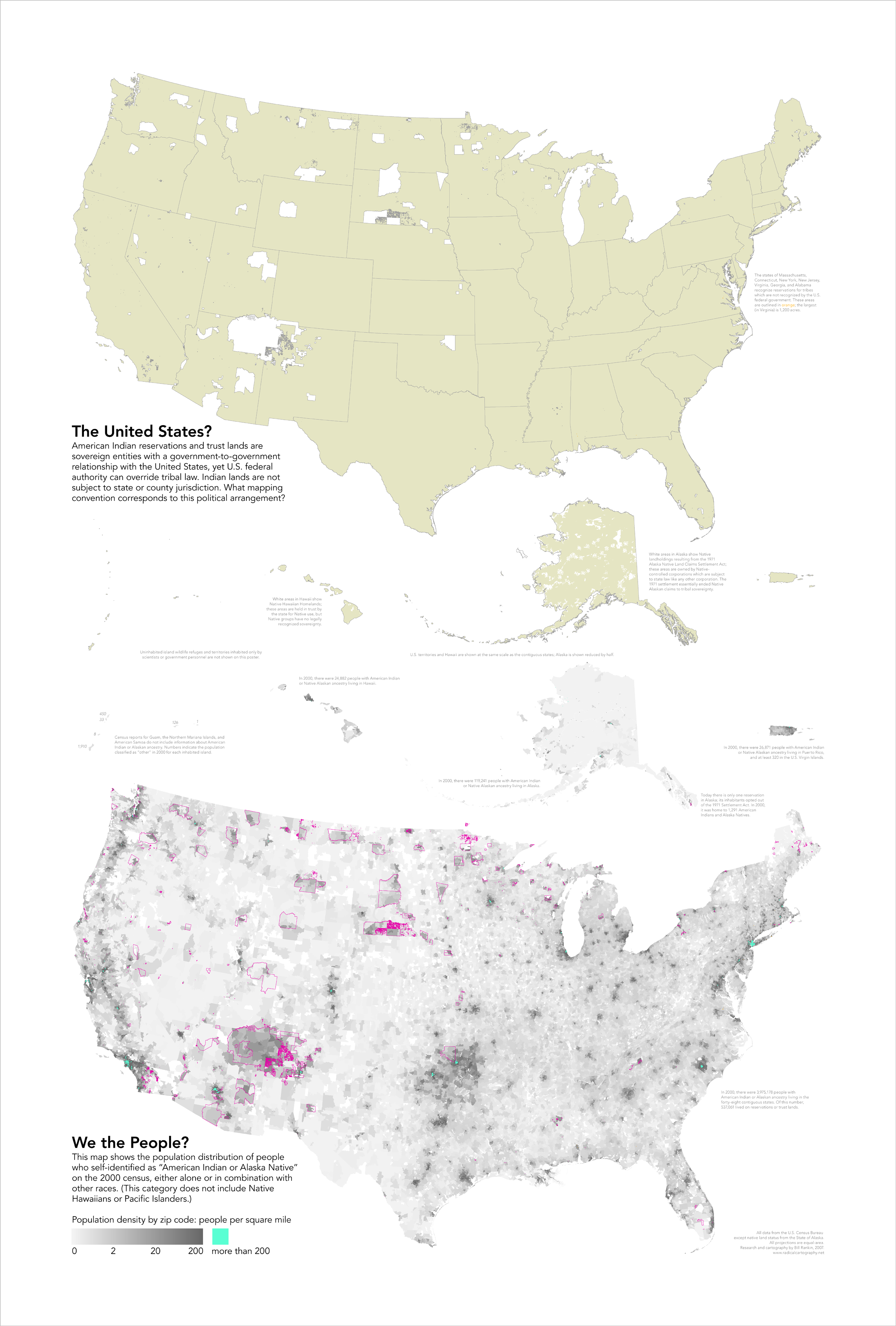
- (Note for the record: Because this talk page post has remained unanswered for quite some time I've gone ahead and used Special:EmailUser to send an email with roughly the same contents as above to Citynoise) —The Editor's Apprentice (talk) 21:25, 8 February 2020 (UTC)
ArbCom 2020 Elections voter message[edit]
"List of domes" listed at Redirects for discussion[edit]
![]() A discussion is taking place to address the redirect List of domes. The discussion will occur at Wikipedia:Redirects for discussion/Log/2021 June 19#List of domes until a consensus is reached, and anyone, including you, is welcome to contribute to the discussion. –LaundryPizza03 (dc̄) 19:37, 19 June 2021 (UTC)
A discussion is taking place to address the redirect List of domes. The discussion will occur at Wikipedia:Redirects for discussion/Log/2021 June 19#List of domes until a consensus is reached, and anyone, including you, is welcome to contribute to the discussion. –LaundryPizza03 (dc̄) 19:37, 19 June 2021 (UTC)
ArbCom 2021 Elections voter message[edit]
ArbCom 2022 Elections voter message[edit]
Hello! Voting in the 2022 Arbitration Committee elections is now open until 23:59 (UTC) on Monday, 12 December 2022. All eligible users are allowed to vote. Users with alternate accounts may only vote once.
The Arbitration Committee is the panel of editors responsible for conducting the Wikipedia arbitration process. It has the authority to impose binding solutions to disputes between editors, primarily for serious conduct disputes the community has been unable to resolve. This includes the authority to impose site bans, topic bans, editing restrictions, and other measures needed to maintain our editing environment. The arbitration policy describes the Committee's roles and responsibilities in greater detail.
If you wish to participate in the 2022 election, please review the candidates and submit your choices on the voting page. If you no longer wish to receive these messages, you may add {{NoACEMM}} to your user talk page. MediaWiki message delivery (talk) 00:21, 29 November 2022 (UTC)
Railway Map of North America 2000[edit]
I am writing to cite your excellent railway map of North America, https://en.wikipedia.org/wiki/File:North_American_Rail.gif Ideally, I need a link to the file on your radicalcartography site. Thanks for making such a great map! John Strong VA0757 (talk) 14:41, 31 December 2023 (UTC)