
Talk:List of sovereign states and dependent territories in Europe/Archive 5
| This page is an archive of past discussions. Do not edit the contents of this page. If you wish to start a new discussion or revive an old one, please do so on the current talk page. |
Unsourced content removed
I removed a sentence which was added recently: [1] and has been tagged as "citation needed" for several months. I tried to find sources that supported the statement that "Russia is considered to be a European country"; the results were mixed. Some reliable sources do say this, while others contrast Russia with Europe, in geographical, political, and cultural contexts, see this article for example: [2]. Therefore I believe that simplistic statments that "Russia is European" are not helpful. Whether, by whom, and in what contexts Russia is considered a "European country", or its citizens "European", is complex. Statements about this must not take sides, but explain the sides, with appropriate weight in proportion to the prominence of each viewpoint in the published, reliable sources.
I also removed the map per WP:NOR / WP:SYN, since it presented a specific interpretation of the borders of Europe etc., but did not cite a published, reliable source that verifies it. There are complaints of inaccuracy on its talk page. Its history shows that it has been modified by numerous edits that don't follow an identifiable source, and/or "combine material from multiple sources to reach or imply a conclusion not explicitly stated by any of the sources". --IamNotU (talk) 16:38, 28 December 2020 (UTC)
- I understand why you made the edits that you describe above, but I'll add my own two cents: The article is poorer if it does not include a map with Europe's geographic boundaries so that readers can see what Europe actually is. None of the controversy has been regarding whether the Bosporus, Sea of Marmara and the Dardanelles form part of the border between Europe and Asia, but merely regarding how to describe countries that are geographically partly within Europe and partly within Asia (such as, most prominently, Russia and Turkey). While there has been been some discussion about the source of the map, please note that it is consistent with the "modern definition" of the boundaries between Europe and Asia described in detail, and with adequate reliable sourcing, in Boundaries between the continents of Earth. I think that the map should be added back in. AuH2ORepublican (talk) 17:51, 28 December 2020 (UTC)
- I agree with (talk) the map should be reinstated. The map is geographically sound and is not getting into anything complex or controversial. QeeGeeBee (talk) 19:24, 28 December 2020 (UTC)
-
- I'm not opposed to having a map, but it needs to come from a reliable source. There are three maps at Boundaries between the continents of Earth § Modern definition and half a dozen others on commons, all different. The text there gives one definition cited to National Geographic Atlas of the World (it also cites CIA World Factbook, but the latter doesn't seem to verify it, showing only a map of Azerbaijan). I don't have access to the National Geographic source; can anyone confirm that File:Europe Asia transcontinental.png does faithfully correspond to it, such that it could be cited? If you compare it to the map published by Britannica for example: [3], there seem to be some conspicuous differences. Since there are several different interpretations of what the borders of the European continent are, if we are going to present just one of those on a map, it can't be done in Wikipedia's voice - WP:NPOV requires that it be "according to reliable source xyz", not "according to anonymous Wikipedia editors". --IamNotU (talk) 22:20, 28 December 2020 (UTC)
-
- If you go to the Europe article you will see the concensus achieved in the first map, with everything in Green highlighted as Europe and the most widley accepted borders of Europe geographically. You are correct though in that the CIA world fact book categorizes several of these transcontinental or geopolitically complicated nations differently, which is an interesting point. QeeGeeBee (talk) 22:56, 28 December 2020 (UTC)
- Not to belabor the point, but the borders of Europe are not to be drawn by a consensus of Wikipedia editors. The verifiability policy overrides any local consensus. As far as I can tell, the borders as shown are not widely accepted. Wikipedia must not publish a map that doesn't correspond to or is not verified by any other published source. Why should we choose that unsourced map over this unsourced map: File:Europe continents.svg? At least it's a lot closer to Britannica's, and to the sourced descriptions in the text.
- It's a bit difficult to decipher the history, but the green map you refer to, as well as the one I removed, and numerous others (File:Asia Europe transcontinental.png, File:Europe subregion map UN geoscheme.svg, etc.), look ultimately to be derivatives of a map drawn by Alinor (talk · contribs) (who hasn't been around for about a decade) sometime around 2006: File:Map of Europe (political).png. It cites the Transcontinental nation article. At that time, the article cited National Geographic and stated that it runs along the Ural river and the Ural mountains to Kara, the same as at present. However, the map doesn't show that. It departs from the Ural river and follows the Russia-Kazakhstan border, taking in a large region east of Orsk. It comes back to the mountains, but veers off to the west, and snakes around wildly. This was pointed out some years ago at the file's talk page on commons [4] but never addressed. I would be very surprised if this is actually what the National Geographic map shows, because there is a quote that it's "formed by the Ural Mountains, Ural River, Caspian Sea", and this is also what I can find on other maps like the Britannica one. The first map on the left at Boundaries between the continents of Earth § Europe and Asia, File:Historical Europe-Asia boundaries 1700 to 1900.png is also derived from the same Alinor file, and shows the same wandering trajectory. That file's description says the "line shows the modern convention following the crest of the Greater Caucasus, the Ural River, and the Urals range. This has been the mainstream convention since about 1850, illustrated by e.g. Johnson (1861)." But Johnson's map shows what is expected: a nearly straight north line from Orsk through the Urals to the sea - as does line "B" on the second map. Furthermore, the Transcontinental nation article at the time had another map, also drawn by Alinor: File:TransAsia.PNG showing a much different border, with a nearly straight line through the Urals, but not following the Ural river from the Caspian sea. It may correspond to line "A" on the second map. It's supposedly based on yet another Alinor map, File:Europe political map.png, which originally showed the straight border until it was replaced in 2008 with the other one by a different user. I can't find any information or discussion explaining on what basis Alinor or others drew these various borders. I can't find any reliable sources that support them, but several - including the ones actually cited in the articles - that contradict them. --IamNotU (talk) 03:05, 29 December 2020 (UTC)
- Britannica uses the Kuma–Manych Depression as the southeast border of Asia and Europe, which is unusual. The usual border is the Caucasus mountains, as given in the source in the article. In that respect, the map matches. As for the Urals, The Myth of Continents source currently in this article notes the area between the Ural mountains and the Ural river is vague. Britannica goes for a straight line (a position the Myth source notes is common), where File:Europe Asia transcontinental.png does an Eastward jag. My suggestion would be to keep using the existing map with a tweak to this Eastern border to match Britannica/other sources. CMD (talk) 03:23, 29 December 2020 (UTC)
- Well, again I would say that it's not the place of Wikipedia editors to be "tweaking" the borders of Europe, based on a patchwork combination of multiple sources. Could we please cite one reliable source that actually verifies a particular border, whatever that may be? Then it would be reasonable to say "according to..." and make a map that follows it as carefully as possible. --IamNotU (talk) 03:34, 29 December 2020 (UTC)
- I was suggesting tweaking the image based on Britannica and the Myth source, who both agree on this point. Per the Myth source: "...the Ural boundary gained near-universal acceptance. Yet this move necessitated a series of further adjustments, since the Ural Mountains do not extend far enough south-or west-to form a complete border...From the mid-1800s on the most common, although by no means universal, solution to this problem was to separate Asia from Europe by a complex line running southward through the Urals, jumping in their southern extent to the Ural river, extending through some two-thirds the length of the Caspian Sea, and turning in a sharp angle to run north-westward along the crest of the Caucasus Mountains...While this geographical boundary between Europe and Asia is now seldom questioned..." CMD (talk) 03:48, 29 December 2020 (UTC)
- Editors are not tweaking borders. The Asia-Europe border has mulitple definitions, none are necessarily right or wrong. Some are just less common or more common. If you want to use the Britannia source to draw a new map then you can. QeeGeeBee (talk) 08:55, 29 December 2020 (UTC)
- My understanding is that IamNotU is specifically concerned with the eastern jag between the Ural Mountains and the Ural River, which they seem correct in claiming it is unsourced. It does not match source maps like File:1861 Johnson Map of Asia - Geographicus - Asia-johnson-1861.jpg. That said, the rest of the map matches both the Johnson Map and the Myth source I quoted above which notes this is the most common view, so I hope it can be agreed that they are not the result of Wikipedia editors tweaking the borders of Europe from a combination of multiple sources. CMD (talk) 13:24, 29 December 2020 (UTC)
- Editors are not tweaking borders. The Asia-Europe border has mulitple definitions, none are necessarily right or wrong. Some are just less common or more common. If you want to use the Britannia source to draw a new map then you can. QeeGeeBee (talk) 08:55, 29 December 2020 (UTC)
- I was suggesting tweaking the image based on Britannica and the Myth source, who both agree on this point. Per the Myth source: "...the Ural boundary gained near-universal acceptance. Yet this move necessitated a series of further adjustments, since the Ural Mountains do not extend far enough south-or west-to form a complete border...From the mid-1800s on the most common, although by no means universal, solution to this problem was to separate Asia from Europe by a complex line running southward through the Urals, jumping in their southern extent to the Ural river, extending through some two-thirds the length of the Caspian Sea, and turning in a sharp angle to run north-westward along the crest of the Caucasus Mountains...While this geographical boundary between Europe and Asia is now seldom questioned..." CMD (talk) 03:48, 29 December 2020 (UTC)
- It is not unusual, the International Geographical Union also uses the Kuma–Manych Depression as the southeast border of Asia and Europe. 2001:8003:9007:8201:84C4:1957:3106:2BB9 (talk) 04:35, 2 October 2022 (UTC)
- Well, again I would say that it's not the place of Wikipedia editors to be "tweaking" the borders of Europe, based on a patchwork combination of multiple sources. Could we please cite one reliable source that actually verifies a particular border, whatever that may be? Then it would be reasonable to say "according to..." and make a map that follows it as carefully as possible. --IamNotU (talk) 03:34, 29 December 2020 (UTC)
- Britannica uses the Kuma–Manych Depression as the southeast border of Asia and Europe, which is unusual. The usual border is the Caucasus mountains, as given in the source in the article. In that respect, the map matches. As for the Urals, The Myth of Continents source currently in this article notes the area between the Ural mountains and the Ural river is vague. Britannica goes for a straight line (a position the Myth source notes is common), where File:Europe Asia transcontinental.png does an Eastward jag. My suggestion would be to keep using the existing map with a tweak to this Eastern border to match Britannica/other sources. CMD (talk) 03:23, 29 December 2020 (UTC)
- If you go to the Europe article you will see the concensus achieved in the first map, with everything in Green highlighted as Europe and the most widley accepted borders of Europe geographically. You are correct though in that the CIA world fact book categorizes several of these transcontinental or geopolitically complicated nations differently, which is an interesting point. QeeGeeBee (talk) 22:56, 28 December 2020 (UTC)
![[3]](https://cdn.britannica.com/67/367-050-0F839196/Europe.jpg)
.png)
![[4]](https://commons.wikimedia.org/wiki/File_talk:Europe_Asia_transcontinental.png)
There's the large jag to the east of Orsk, and also three or four large jags above that, including one that looks like it goes far to the west side of the Urals to include Ufa and run along the Belaya river before coming back to the east side. QeeGeeBee, it doesn't matter to me what definition we use, as long as it cites and follows a reliable source. The map by Alinor doesn't look like any other map or text description I can find, and there's no explanation or source for why it's drawn that way. As far as I can tell it's original research, trying to include/exclude certain locations for reasons unknown.
If a map cites Britannica, it would have to show the southern border as the Kuma–Manych Depression. Otherwise I don't think it can be cited, even if the rest of it agrees with another source. That's what I mean by combining sources (unless both lines are shown, which is a possibility). So if the preference is to show the Caucusus watershed, what good-quality source can be cited? There must something more recent than Johnson? It would be better if it was an actual map, rather than a text description. It would also be nice if it was accessible online, unlike the National Geographic atlas. Unfortunately I have no map-making skills, so I don't think I'd be able to create a replacement. Nevertheless, I'd ask that Alinor's map not be restored, since it can't be verified. --IamNotU (talk) 23:25, 29 December 2020 (UTC)
- I will look for a map from a reliable and accesible online source! Britannica and Seterra seems to both follow the Kuma–Manych Depression and have recent maps, the CIA world factboook and UN Geoscheme are also reliable and have maps but follow differnt bordering breakdowns QeeGeeBee (talk) 00:26, 30 December 2020 (UTC)
- The map was not necessarily bad, but we have to carefully phrase any text of ot, not to import again similar issues as above. As well, if any new map is waated, it's appropriate being should be discussed here and first to be presented here as well for consensus.(KIENGIR (talk) 01:11, 30 December 2020 (UTC))
- 1901 with a curious second border for "Russia proper". At any rate, we shouldn't be looking just at primary map sources as we have a secondary source on the matter, even if it is text. The solution per these (primary and secondary) sources is straightening the southern Ural line in File:Europe Asia transcontinental.png, and other maps like File:Historical Europe-Asia boundaries 1700 to 1900.png which cites Johnson as the source but doesn't exactly follow it. CMD (talk) 02:39, 30 December 2020 (UTC)
- If we're going to use a map drawn by a Wikipedia editor, it has to at least try to exactly follow an actual, published map. There will be some margin of error in reproducing it, but that's different from fudging something to fit a general concept and making judgement calls that can arbitrarily deviate by hundreds of kilometers. Citing a source map allows readers to go to verify it and say, "hey, there's a mistake here".
- The text description in "The Myth of Continents" doesn't give enough detail to actually draw a map. Does it follow the crest of the Urals, or maybe its eastern foot? Does it meet the Kara Sea at the southernmost tip of Baydaratskaya Bay, as Johnson draws it, or follow the Kara river, 200 km to the northwest, as Redway's 1901 map (and Alinor's) shows? A secondary source is desirable, and if we can find one that shows a map that's a generalization or synthesis of other maps, we can follow that, but we can't do that ourselves. Otherwise it should be based on a primary map that's referenced by a secondary source ("Myths" mentions S. Hall and Hughes 1856, map 1; Stieler 1865, map 5; Colton 1856, map v., but not Johnson) and cite them both. --IamNotU (talk) 18:51, 30 December 2020 (UTC)
- I think the second map presented by CMD is a good introduction for demonstration, while the third one is the best to demonstrate the difference between interpretations.(KIENGIR (talk) 01:00, 31 December 2020 (UTC))
- The Myth source cites Conrad Malte-Brun as key in establishing the Ural boundary: "After the noted French geographer M. Malte-Brun gave it his seal of approval in the nineteenth century, the Ural border gained near-universal acceptance". We have one of Malte-Brun's maps on Commons at File:1832 Malte-Brun Map of the World on Mercator Projection - Geographicus - Mappemonde-mb-1832.jpg. I suggest we use them together to meet IamNotU's request for a primary and secondary source pair. CMD (talk) 02:31, 5 January 2021 (UTC)
- Yes, we can use this also.(KIENGIR (talk) 12:23, 6 January 2021 (UTC))
- I found a map here: [5] that resembles the Eastern border drawn in Alinor's map, though it then follows the Kazakhstan border rather than the Ural River to the Caspian Sea, so it's not the same. It would be nice if we could cite a contemporary map, because it's not only this article, but eventually all maps based on Alinor's, like the File:Europe orthographic Caucasus Urals boundary (with borders).svg at the top of the Europe article, that need citations. Again, some of the articles cite the National Geographic Atlas map, but I can't find that online; this one for example [6] doesn't actually draw the border, but gives only the text description: "A commonly accepted division between Asia and Europe is formed by the Ural Mountains, Ural River, Caspian Sea, Caucasus Mountains, and the Black Sea with its outlets, the Bosporus and Dardanelles." PS, the more I research this, the less I'm convinced of the "near universal acceptance" - maybe of the Ural Mountains generally, but the rest, not so much. --IamNotU (talk) 22:47, 11 January 2021 (UTC)
- I see no problem if based on CMD's suggestions we present a few alternatives, e.g. in the max amount of 3 maps.(KIENGIR (talk) 14:32, 12 January 2021 (UTC))
- You mean to present several of the originals, not a Wikipedia-style facsimile? I think that would be fine in the main relevant articles like Europe and Boundaries between the continents of Earth. But it seems a bit much to have in every "List of xyz in Europe" article. File:Europe Asia transcontinental.png is hardly used anywhere, but File:Europe orthographic Caucasus Urals boundary (with borders).svg for example is used in dozens of articles. I think that a sort of generic map like that is not a bad idea - it just needs to be based on and cite a reliable source. I suspect that Alinor's map is based on a synthesis of different sources, and maybe some original research. It's possible it was based on one reliable source (National Geographic?), but it's not cited, I can't verify or find evidence of it, and the user is no longer around. --IamNotU (talk) 15:56, 12 January 2021 (UTC)
- Well the type is marginal if has a representational value. Given the fact there are more interpretations, we don't represent something carved in a stone, but appropriately attribute the different considerations.(KIENGIR (talk) 15:40, 13 January 2021 (UTC))
- I can't see the Kid Atlas cited above, but if a contemporary map is wanted, DK 2016 has two different borders on the same page, one of which has the Eastern jag and one which just fades out, both also just following the political border of Russia for Kazakhstan and the Caucasus. However, I think a series of maps would be undue here, as how exactly the line winds down the Urals and towards the Ural River, and even how it passes through the Caucasus, doesn't really affect the contents of this page since it has a very expansive inclusion criteria. CMD (talk) 15:53, 13 January 2021 (UTC)
- Looks like Google changed their system again, I can't access it now either. Anyway, the one in the DK Atlas above is the same one, it's found in several of DK's books. I agree that just one map here would be ok, if the source is cited and there's a link to the other articles with more detail. I'd be ok with using the DK map, though it does contradict the existing text about the Ural River, and Kazakhstan being transcontinental (see also the footnote in its entry) and thereby its inclusion in this list. If we use only one map, I guess we should try, to the extent that it's possible, to use one that is typical of what the greatest proportion of reliable sources say. If that does indeed include the Ural River as being almost univerally accepted, then most likely we should use one that shows that. But I'm not really sure at this point. If there isn't something that's close to universally accepted, then it probably doesn't matter much which one we use, as long as it cites a high-quality source and notes that there are other definitions. The most convenient thing would be to find a published map that shows essentially what Alinor's map shows - then we could cite it, and be done with it, and wouldn't have to change any of the many dozens of other Wikipedia maps based on it - including all the separate ones for each entry in this list. Thus far, I haven't been able to find such a map. --IamNotU (talk) 18:37, 13 January 2021 (UTC)
- I can't see the Kid Atlas cited above, but if a contemporary map is wanted, DK 2016 has two different borders on the same page, one of which has the Eastern jag and one which just fades out, both also just following the political border of Russia for Kazakhstan and the Caucasus. However, I think a series of maps would be undue here, as how exactly the line winds down the Urals and towards the Ural River, and even how it passes through the Caucasus, doesn't really affect the contents of this page since it has a very expansive inclusion criteria. CMD (talk) 15:53, 13 January 2021 (UTC)
- Well the type is marginal if has a representational value. Given the fact there are more interpretations, we don't represent something carved in a stone, but appropriately attribute the different considerations.(KIENGIR (talk) 15:40, 13 January 2021 (UTC))
- You mean to present several of the originals, not a Wikipedia-style facsimile? I think that would be fine in the main relevant articles like Europe and Boundaries between the continents of Earth. But it seems a bit much to have in every "List of xyz in Europe" article. File:Europe Asia transcontinental.png is hardly used anywhere, but File:Europe orthographic Caucasus Urals boundary (with borders).svg for example is used in dozens of articles. I think that a sort of generic map like that is not a bad idea - it just needs to be based on and cite a reliable source. I suspect that Alinor's map is based on a synthesis of different sources, and maybe some original research. It's possible it was based on one reliable source (National Geographic?), but it's not cited, I can't verify or find evidence of it, and the user is no longer around. --IamNotU (talk) 15:56, 12 January 2021 (UTC)
- I see no problem if based on CMD's suggestions we present a few alternatives, e.g. in the max amount of 3 maps.(KIENGIR (talk) 14:32, 12 January 2021 (UTC))
- The Myth source cites Conrad Malte-Brun as key in establishing the Ural boundary: "After the noted French geographer M. Malte-Brun gave it his seal of approval in the nineteenth century, the Ural border gained near-universal acceptance". We have one of Malte-Brun's maps on Commons at File:1832 Malte-Brun Map of the World on Mercator Projection - Geographicus - Mappemonde-mb-1832.jpg. I suggest we use them together to meet IamNotU's request for a primary and secondary source pair. CMD (talk) 02:31, 5 January 2021 (UTC)
- I think the second map presented by CMD is a good introduction for demonstration, while the third one is the best to demonstrate the difference between interpretations.(KIENGIR (talk) 01:00, 31 December 2020 (UTC))
- 1901 with a curious second border for "Russia proper". At any rate, we shouldn't be looking just at primary map sources as we have a secondary source on the matter, even if it is text. The solution per these (primary and secondary) sources is straightening the southern Ural line in File:Europe Asia transcontinental.png, and other maps like File:Historical Europe-Asia boundaries 1700 to 1900.png which cites Johnson as the source but doesn't exactly follow it. CMD (talk) 02:39, 30 December 2020 (UTC)
- The map was not necessarily bad, but we have to carefully phrase any text of ot, not to import again similar issues as above. As well, if any new map is waated, it's appropriate being should be discussed here and first to be presented here as well for consensus.(KIENGIR (talk) 01:11, 30 December 2020 (UTC))
.svg)
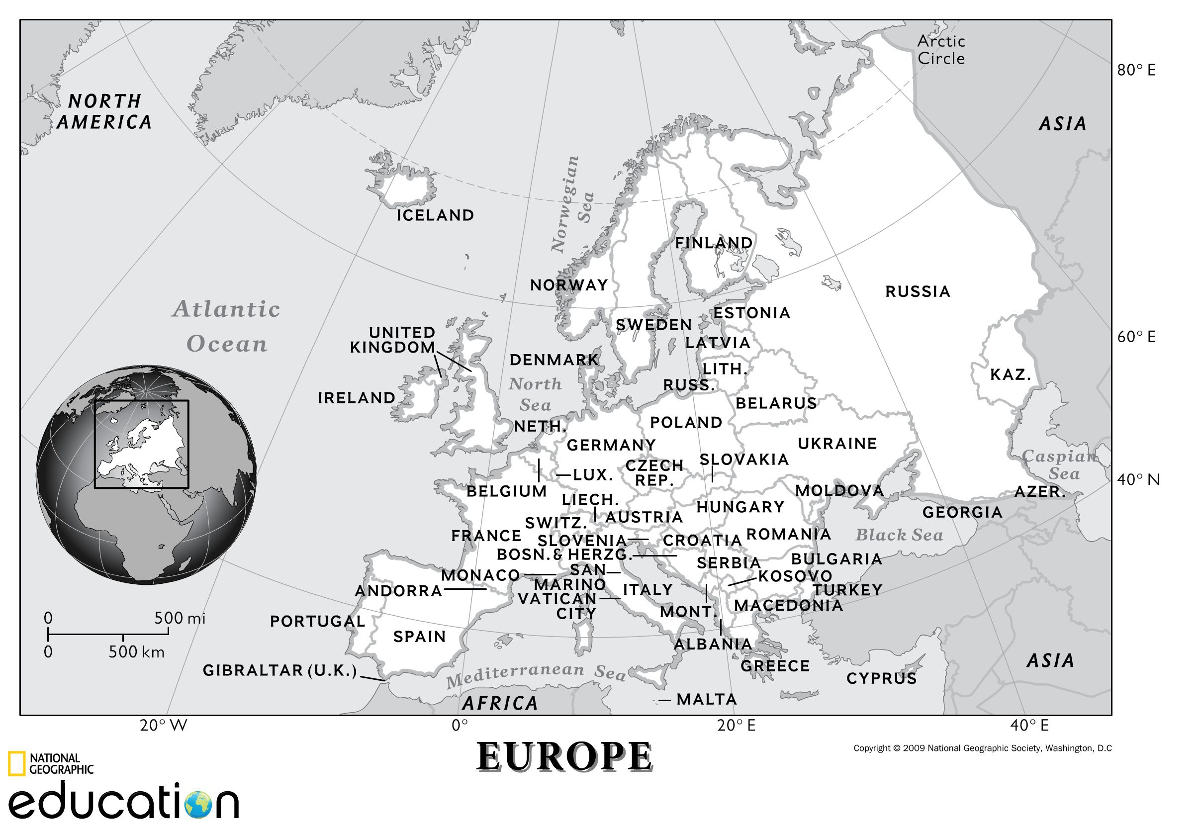
Found a 2009 National Geographic map here. No eastward jag, consistent with the other maps discussed above which all lack a similar jag, otherwise it is a match for the base image. CMD (talk) 13:43, 1 April 2021 (UTC)
- The most accurate Europe-Asia Boundary Map I could found on the Internet is the one made by Sasha Trubetskoy (link). The map is very detailed and its boundary line follows the actual watersheds of the Greater Caucasus and the Ural Mountains. The 2009 National Geographic map is only half accurate, its boundary line correctly follows the actual watershed of the Greater Caucasus (by showing a small coastal strip from Novorossiysk to Sochi as a part of Western Asia), but it completely missed the portion of Orenburg Oblast south of the Ural River, which is geographically a part of Central Asia. Vic Park (talk) 11:11, 7 October 2022 (UTC)