
Wikipedia talk:WikiProject Maps/Archive 2020
| This is an archive of past discussions. Do not edit the contents of this page. If you wish to start a new discussion or revive an old one, please do so on the current talk page. |
| Archive 2015 | ← | Archive 2018 | Archive 2019 | Archive 2020 |
Please help upgrade my IWG interactive map
I want to expand [1] to turn sets of markers associated with certain IWG brands off and on (as in [2]), and draw File:IWG plc locations.png with different colors by brand. Can anyone offer advice, up to and including doing either or both for me, please?
Also, does anyone have DeepSpeech working for city search by voice anywhere in the OSM-verse? EllenCT (talk) 23:34, 7 January 2020 (UTC)
RfC regarding claimed territorial boundaries of a state
The following discussion is closed. Please do not modify it. Subsequent comments should be made on the appropriate discussion page. No further edits should be made to this discussion.
In articles on Wikipedia about political subdivisions with territorial disputes, it is common to show both the de-jure and de-facto boundaries of a division (see below).
_(%2Ball_claims_hatched).svg)


.jpg)
Following the bifurcation of the state of Jammu and Kashmir, I was asked to make some new maps showing these new divisions. These were then cited by Kautilya3 in a discussion as "a good solution for avoiding objections from readers". Consequent to this, Fowler&fowler self-judged that my maps were POV and removed them from all articles present.
The question is very simply to establish a common consensus across Wikipedia on whether territorial claims should, or should not be present in any articles about political subdivisions.
--RaviC (talk) 10:48, 11 November 2019 (UTC)
- Comment of user:Fowler&fowler. I request that this RfC be closed for the reason that it is premature, that well-worn methods of resolution on India and Pakistan related pages have not been explored. (a) There is already an ongoing discussion Talk:Jammu_and_Kashmir_(union_territory)#Three_map_proposal which has had no input yet not only from the editor who first posted his comment, but from a large number of editors and administrators that usually contribute to Kashmir-related pages. (b) There has already been a proposal and discussion for a Kashmir-related RfC on WT:INDIA, opened August 15, 2019. Most editors in pages of Pakistan-administered Kashmir and Indian-administered Kashmir are following the proposed wording of that discussion. Again, there are a large number of editors and administrators involved in that discussion. This editor, moreoever, has been absent from that discussion. (c) As I have been on vacation, I posted a note on the Talk:Jammu and Kashmir (union territory) on October 31, 2019 stating that the language of the proposed RfC be followed both in the text and the infobox. Please note the number of editors and administrators pinged there. (d) The editor has to first take the discussion to WT:INDIA. He can't fly under the radar and start an RfC on a whim, because he feels miffed that I have reverted his very recent additions. There is a limited amount of editor-power on India- and Pakistan-related pages. Most editors don't pay close attention to subtle changes made in maps by the graphics-programming editors, so edits in maps can sometimes escape notice and survive in maps for more time than they would in the text. It also does not help to throw around generalized jargon such as "de facto" and "de jure." Kashmir is the oldest dispute before the UN. Kashmir-related pages have special ARBCOM restrictions. The issues have been endlessly debated on Talk:Kashmir, Talk:Jammu and Kashmir (state), Talk:Gilgit-Baltistan, Talk:Azad Kashmir, debates in which this editor has been absent. Best regards, Fowler&fowler«Talk» 13:50, 11 November 2019 (UTC)
- I see that I may have precipitated the opening of this RfC by saying to this editor, "I am afraid none are transparent, or even written in idiomatic English. You are welcome to go to a Wikipedia forum of your choice and establish their congruence with the Kashmir conflict." But I meant, "at the conclusion of our discussion, not midway through the discussion." Fowler&fowler«Talk» 14:38, 11 November 2019 (UTC)
- This RfC was indeed started due to your suggestion. It, however, is aimed at finding a common position throughout Wikipedia, not just for the Indian subcontinent. Thus, regardless of the discussion, it's important to see what the position of the community is as a whole as opposed to self-arbitration. --RaviC (talk) 14:50, 11 November 2019 (UTC)
- Please see WP:RfC. It says clearly, "Editors are normally expected to make a reasonable attempt at working out their disputes before seeking help from others. If you are able to come to a consensus or have your questions answered through discussion with other editors, then there is no need to start an RfC." Have you tried the usual channels? Have you even finished the discussion you joined half-way through? Have you taken the issue to WT:INDIA? Have you discussed this on Talk:Kashmir? On Talk:India, on Talk:Pakistan? I say this as the major contributor to: Kashmir, to Talk:Kashmir, to India, on Talk:India to History of Pakistan. And I have over 500 edits on the talk page of the project on India-related topics. If you have contributed anything to these pages, or to discussions on them, it has not come to my notice. I have not seen you anywhere. It is perplexing how you have turned up here. You have made maps, but you have no earlier history of discussing the POV content of maps. You need to go through the usual channels first, like the rest of us do. Fowler&fowler«Talk» 16:00, 11 November 2019 (UTC)
- I've been on Wikipedia since 2006, and a large portion of my edits are related to India. The fact that we haven't interacted prior to this is neither here nor there. You do not own the site. --RaviC (talk) 20:15, 11 November 2019 (UTC)
- Creators of graphics are often given a lot of leeway and thanked for their attractive work. However, on issues as sensitive as those discussed at Talk:Jammu and Kashmir (union territory), steam rolling images and making claims of WP:OWN is not satisfactory. This is not the right page to discuss whether a particular map is suitable for use in a particular topic: use the talk page for the topic. Johnuniq (talk) 06:56, 12 November 2019 (UTC)
- I appreciate your reply, but "steam rolling" isn't an accurate description of what happened. I was asked to make a few maps at the graphics lab. The only person who has criticised them is the user above, who has made no serious attempts to engage in constructive discussion, assumed bad faith from the first comment he made and assumed that the fact we hadn't talked previously meant that I had not contributed to relevant talk page discussions in the past (which is simply not true). --RaviC (talk) 14:30, 12 November 2019 (UTC)
- I also agree that this is probably not the best place for this, as there's an ongoing discussion at WT:INDIA. And for the record, I think the maps are problematic as well. Of course, this is a very tricky situation, but normally I'd expect maps of administrative divisions to show first and foremost the actual extent of the territory administered. Claims are relevant but not as relevant as they are for sovereign states. So in my opinion maps should either show just the territory administered (as do the Taiwan and Crimea maps above), or also show the claimed territory, but in a distinctive manner. Ideally that's done with cross-hatching (as in the above map of Tibet), with the lines being thicker in the colour of the territory that's actually in control. Conversely, symbolising the two types of territories in the same way (with the same colour as for the maps of Cyprus, or with two very similar colours as for the Kashmir maps under discussion) is not in my opinion appropriate. – Uanfala (talk) 14:49, 12 November 2019 (UTC)
- I see your point. Cross-hatching is not a bad idea and I'm open to making that change if it can gain consensus. --RaviC (talk) 20:20, 12 November 2019 (UTC)
- @RaviC: I don't think you see the point. There is no consensus here as yet for having this discussion here. In fact, the consensus is against it. Fowler&fowler«Talk» 20:36, 12 November 2019 (UTC)
- I see your point. Cross-hatching is not a bad idea and I'm open to making that change if it can gain consensus. --RaviC (talk) 20:20, 12 November 2019 (UTC)
- I also agree that this is probably not the best place for this, as there's an ongoing discussion at WT:INDIA. And for the record, I think the maps are problematic as well. Of course, this is a very tricky situation, but normally I'd expect maps of administrative divisions to show first and foremost the actual extent of the territory administered. Claims are relevant but not as relevant as they are for sovereign states. So in my opinion maps should either show just the territory administered (as do the Taiwan and Crimea maps above), or also show the claimed territory, but in a distinctive manner. Ideally that's done with cross-hatching (as in the above map of Tibet), with the lines being thicker in the colour of the territory that's actually in control. Conversely, symbolising the two types of territories in the same way (with the same colour as for the maps of Cyprus, or with two very similar colours as for the Kashmir maps under discussion) is not in my opinion appropriate. – Uanfala (talk) 14:49, 12 November 2019 (UTC)
- I appreciate your reply, but "steam rolling" isn't an accurate description of what happened. I was asked to make a few maps at the graphics lab. The only person who has criticised them is the user above, who has made no serious attempts to engage in constructive discussion, assumed bad faith from the first comment he made and assumed that the fact we hadn't talked previously meant that I had not contributed to relevant talk page discussions in the past (which is simply not true). --RaviC (talk) 14:30, 12 November 2019 (UTC)
- Creators of graphics are often given a lot of leeway and thanked for their attractive work. However, on issues as sensitive as those discussed at Talk:Jammu and Kashmir (union territory), steam rolling images and making claims of WP:OWN is not satisfactory. This is not the right page to discuss whether a particular map is suitable for use in a particular topic: use the talk page for the topic. Johnuniq (talk) 06:56, 12 November 2019 (UTC)
- I've been on Wikipedia since 2006, and a large portion of my edits are related to India. The fact that we haven't interacted prior to this is neither here nor there. You do not own the site. --RaviC (talk) 20:15, 11 November 2019 (UTC)
- Please see WP:RfC. It says clearly, "Editors are normally expected to make a reasonable attempt at working out their disputes before seeking help from others. If you are able to come to a consensus or have your questions answered through discussion with other editors, then there is no need to start an RfC." Have you tried the usual channels? Have you even finished the discussion you joined half-way through? Have you taken the issue to WT:INDIA? Have you discussed this on Talk:Kashmir? On Talk:India, on Talk:Pakistan? I say this as the major contributor to: Kashmir, to Talk:Kashmir, to India, on Talk:India to History of Pakistan. And I have over 500 edits on the talk page of the project on India-related topics. If you have contributed anything to these pages, or to discussions on them, it has not come to my notice. I have not seen you anywhere. It is perplexing how you have turned up here. You have made maps, but you have no earlier history of discussing the POV content of maps. You need to go through the usual channels first, like the rest of us do. Fowler&fowler«Talk» 16:00, 11 November 2019 (UTC)
- This RfC was indeed started due to your suggestion. It, however, is aimed at finding a common position throughout Wikipedia, not just for the Indian subcontinent. Thus, regardless of the discussion, it's important to see what the position of the community is as a whole as opposed to self-arbitration. --RaviC (talk) 14:50, 11 November 2019 (UTC)
- I see that I may have precipitated the opening of this RfC by saying to this editor, "I am afraid none are transparent, or even written in idiomatic English. You are welcome to go to a Wikipedia forum of your choice and establish their congruence with the Kashmir conflict." But I meant, "at the conclusion of our discussion, not midway through the discussion." Fowler&fowler«Talk» 14:38, 11 November 2019 (UTC)
- I don't see how there can be a single, blanket answer to this question. It should be decided on a case-by-case basis following reliable sources. If there's a dispute, a consensus should be reached on the article talk page. – Joe (talk) 07:28, 12 November 2019 (UTC)
- Agree with Joe above. There will be articles where a discussion on territorial claims is warranted and others where it isn't. I should also point out that, even where such claims are relevant, a map may not be necessary. --regentspark (comment) 22:51, 12 November 2019 (UTC)
- For what it is worth, I think RaviC is right to bring this issue here, because there is a question regarding a generical principle: should a country's division/subdivision maps show its claimed-but-unadministered territories as the country itself represents them? When the subject is discussed on Wikipedia, I often find wording such as "country X claims a particular area as part of its division Y". If the reader is to understand what that means, I think it needs to be illustrated in the division Y's map. (I oppose the Indian government's fiddling with the maps by the way. But setting aside my views, I am wondering what is the NPOV thing to do.) -- Kautilya3 (talk) 08:48, 13 November 2019 (UTC)
- I agree with what Kautilya3 has said regarding the relevance of this RfC. I don't see the harm in showing a country's administrative understanding of its claimed areas. IMO, three different versions of a map can be used: one which illustrates the administrative divisions from the claimant's POV, one for the occupant's POV, and a third one which specifies both of them. The first two can be used in country-specific articles (for example, the map in Jammu and Kashmir (union territory) should illustrate India's understanding of its state borders, whereas Gilgit-Baltistan should illustrate Pakistan's; nevertheless the actual international borders have to specified in both cases). The third map can be used in articles such as Kashmir dispute, although the internal borders can be ignored in such articles. The India-Pakistan scenario is not an isolated one; a reverse case also exists. India views Aksai Chin as part of Ladakh whereas China considers it to be part of Xinjiang and Tibet. That is why a general policy should be created to handle all such cases that exist or may arise in the future. Bharatiya29 15:11, 13 November 2019 (UTC)
- @Kautilya3: There is no general principle, no generic principle, no characteristic of every genus or class. However, there are precedents, such as in:
- (a) Kashmir-related maps of the countries that are a party to the Kashmir dispute, (b) neutral third-party sources whose maps on Kashmir we generally follow
- (a) (i) The Indian-administered regions: On October 31, 2019, the government of India produced rudimentary, largely unlabeled, maps of the new union territories of Jammu and Kashmir (union territory) or Ladakh, hereafter RUD2019. Earlier, from 1954 to 2019, Jammu, Kashmir, and Ladakh were divisions of the state of Jammu and Kashmir, and they are now divisions of the union territory (see Kashmir Division, Jammu Division) No map was produced by India's government in the previous 45 years showing the boundaries of these divisions supplemented with a "claimed Divison boundary" which extended into Pakistani-administered Kashmir, i.e. into Azad Kashmir or Gilgit-Baltistan. In other words, there is no precedent for RUD2019 in India's own official cartography.
- (a) (ii) The makers of RUD2019 forgot to break down the claims of these union territories into claims of their Divisions. So, what kind of claim of administration does the map embody? It has an overall claim but no detailed breakdown. What parts of Azad Kashmir (administered by Pakistan) lie in the claim of their Kashmir Division and what in that of their Jammu Division? In other words, there is no supplement for RUD2019, identifying its details, in any official Indian map produced since October 31, 2019.
- (a) (iii) The Pakistan-administered regions: The maps of Gilgit-Baltistan in Pakistan government maps, for example, here, do not show Kargil (which today lies in Indian-administered Kashmir) to be a part of the claimed territory of Gilgit-Baltistan. However before the Kashmir dispute began in 1947, Kargil was a part of Baltistan. (The [Imperial Gazetteer of India says so. Many other sources say so: here, here, and here. Thus Pakistan's government maps do not show their claims broken down into claims of their administrative subdivisions. In other words, there is no precedent for RUD2019 in the official cartography of Pakistan.
- (a)(iv) The British Raj: Before 1947, Ladakh and Gilgit were two distinct districts of the princely state of Kashmir and Jammu. (See here, in the Imperial Gazetteer of India). But Gilgit has become a part of Ladakh in RUD2019? In other words, there is no precedent for RUD2019 in the cartography of the British Raj
- (b) The neutral third-party sources such as the University of Texas/CIA map of Kashmir, BBC, Britannica, that we rely on have not as yet chosen to produce a map of India's new union territories.
- Indeed there are several cases in India's Supreme Court, challenging the subdivision of Jammu and Kashmir. By allowing such maps on Wikipedia before the legal dust has settled, we are risking taking sides in the issue. Fowler&fowler«Talk» 16:46, 13 November 2019 (UTC)
- As for you @Bharatiya:, you seem to have a penchant for redundant RfCs that waste community time. May I point out to the participants here you celebrated RfC here on Talk:India, attempting to reorder the lead sentence on Wikipedia's oldest country FA. What did that get you? Please enlighten us. Fowler&fowler«Talk» 16:52, 13 November 2019 (UTC)
- PS In case you are planning to use the cover of the Wiki-legal subterfuge that the RfC was formally begun by someone else, may I point out your stoking the flames before. When people feign curiosity or advertise a search for knowledge, in starting RfCs, but in reality are avoiding the discussions already in progress for reaching a consensus, they are using Wikipedia disruptively. Fowler&fowler«Talk» 17:04, 13 November 2019 (UTC)
- I don't see how a discussion could be in a state of potentially achieving consensus when a certain someone was busy using terms like ridiculous, silly, awful, and craptrap. Such deplorable conduct is what made me suggest an RfC so that a civilized discussion could take place regarding the lead sentence of one of the most important articles out there. Coming back to the actual topic, here are some points that I'll like to make:
- There is a precedent for the latest political map of India released by the Survey General. Pak-administrated Kashmir (which includes both AK and Gilgit-Baltistan) has always been shown as part of the J&K state in past maps, and now that Ladakh has been carved out, Gilgit-Baltistan and a portion of AK is now claimed as part of Ladakh. What does the fact that the Indian maps don't demarcate the divisions in this claimed territory have to do with all this? It's common sense that claimed but not occupied territory will not have an extensively defined administrative structure. India has seats reserved in the J&K assembly for PoK constituencies, but their borders are not defined yet, but that doesn't make its claim any weaker or stronger. All these facts are completely irrelevant to this discussion.
- Whether Pakistan claims J&K and Ladakh as part of any specific state/administrative territory or not has nothing to do with the Indian claim.
- We are not concerned with the historical accuracy of India's official map. WP is an encyclopedia, not a critic group.
- Why should we wait for other sources to update their maps? They may be bounded by diplomatic considerations as acknowledging the reorganization of J&K could be seen as an endorsement of India's recent Kashmir policy. But again, all this is not relevant to us.
- How does showing the ground situation and the current government stand equivalent to taking a side? On the off chance that the SC squashes the reorganization bill, the articles can always be reverted back to their previous state. By this logic, WP articles should not even mention Modi as the Indian PM because a petition was filled in a court challenging his very election as a member of parliament. A really erroneous argument to be honest. Bharatiya29 20:25, 13 November 2019 (UTC)
- I don't see how a discussion could be in a state of potentially achieving consensus when a certain someone was busy using terms like ridiculous, silly, awful, and craptrap. Such deplorable conduct is what made me suggest an RfC so that a civilized discussion could take place regarding the lead sentence of one of the most important articles out there. Coming back to the actual topic, here are some points that I'll like to make:
- PS In case you are planning to use the cover of the Wiki-legal subterfuge that the RfC was formally begun by someone else, may I point out your stoking the flames before. When people feign curiosity or advertise a search for knowledge, in starting RfCs, but in reality are avoiding the discussions already in progress for reaching a consensus, they are using Wikipedia disruptively. Fowler&fowler«Talk» 17:04, 13 November 2019 (UTC)
- As for you @Bharatiya:, you seem to have a penchant for redundant RfCs that waste community time. May I point out to the participants here you celebrated RfC here on Talk:India, attempting to reorder the lead sentence on Wikipedia's oldest country FA. What did that get you? Please enlighten us. Fowler&fowler«Talk» 16:52, 13 November 2019 (UTC)
- Final comment by Fowler&fowler: Since this discussion is taking place in two places, I would like to urge again that this RfC be closed. If you don't think there is enough weight of opinion for its closing in the comments above, consider this post I just made on Talk:Jammu and Kashmir (union territory), unraveling the POV content of the original map of RaviC (talk · contribs) that I had reverted. It has nothing to do with Cyprus or Taiwan, only with not following the Wikipedia rules on sourcing. Best regards, Fowler&fowler«Talk» 01:52, 14 November 2019 (UTC)

Special member state territories and the European Union
According to an IP editor on Talk:Special member state territories and the European Union, "The map in the Info Box at the top of this page still incorrectly includes some of the British Overseas Territories. The Pitcairn Islands (Pacific Ocean), Turks & Caicos Islands, British Virgin Islands, Anguilla, Montserrat, Cayman Islands (Caribbean Sea) are still showing and need to be deleted." I thought I'd bring this to the attention of this project. -- The Anome (talk) 10:11, 3 February 2020 (UTC)
Switch between regions
Hi. I would like some help to improve this map about the locations of editathons. There is a cluster of activity in the United States, which is very interesting. I would like to be able to switch between the USA and the World without having to create different maps for each. -Masssly (talk) 09:48, 5 February 2020 (UTC)
Historical maps
Cartography of Jerusalem is now a Featured List. I believe this is the first time, anywhere in Wikipedia, that we have a fully developed article on the history of mapmaking of a city or country. The template below summarizes all the similar articles we have across the encyclopaedia; if anyone in this wikiproject is aware of any other similar articles, please add them to this template. Thanks, Onceinawhile (talk) 10:17, 8 February 2020 (UTC)
List of fictional counties up for deletion
- Find sources: Google (books · news · scholar · free images · WP refs) · FENS · JSTOR · TWL
- List of fictional counties (3rd nomination) (edit|talk|history|links|watch|logs|google) AfD discussion
- Wikipedia:Articles for deletion/List of fictional counties (3rd nomination)
I've added some sources. More are out there. Important literary device. Important list for some of our readers. 7&6=thirteen (☎) 15:25, 31 March 2020 (UTC)
need support for a West New Guinea map
Hi. I'd like to add a topographic locator map to Lakes Plain. The only suitable map I see on Commons is File:Papua Locator Topography.png, but the coordinates haven't been added to the Lua module. Could someone do that, or is there a supported map that would work? (The only other topographic map of WNG that I see doesn't show the Lakes Plain.) — kwami (talk) 22:38, 31 March 2020 (UTC)
- The module where this should ideally be added is Module:Location map/data/Indonesia Western New Guinea: the projection is probably the same, though the spatial extent of the edges is not an exact match. – Uanfala (talk) 22:46, 31 March 2020 (UTC)
I don't know how to do that so it calls properly. — kwami (talk) 22:55, 31 March 2020 (UTC)
- Another thing: the Lakes Plain are a bit too big to be reasonably represented by a dot on the pushpin maps. Maybe it will be better to have a derived image map with the extent of the plain highlighted? – Uanfala (talk) 22:52, 31 March 2020 (UTC)
@Uanfala: Yes, that would be better. I found a nice schematic map in Ronald G. Petocz (1989) Conservation and Development in Irian Jaya, p. 8 (page after here). If it's possible for the map project to duplicate that map -- with the rivers and shaded mountainous regions preserved but without the names -- it would be useful for dozens of West Papuan geo features. — kwami (talk) 22:49, 1 April 2020 (UTC)
Rene Cinquin and Aero-View Company
Could somebody please take a look at Draft:Rene Cinquin. Per my comments there, there's nowhere near enough good sourcing to justify a stand-alone article, but this seems like an important footnote in American map making, and I'd hate to see this disappear completely. Is there some existing article into which this might reasonably fit? -- RoySmith (talk) 23:00, 3 May 2020 (UTC)
Side by side georeferenced maps
this lets you compare modern and older OS maps - have fun EdwardLane (talk) 17:08, 5 May 2020 (UTC)
Operator map convention
I'm working on converting a bunch of "operator" maps to SVG after I realised how nice the blank template is, and that it is a relatively easy process as compared to most other non-vector images needing conversion. Is there any convention for colours, etc, for these types of map? Looking at commons:Category:Military Aircraft Operators Maps there seems to be a number of rather bold colours used. --Lewis Cawte (Talk) 12:12, 11 May 2020 (UTC)
RfC on Treaty of Tingmosgang
Hi! There is an RfC about the Treaty of Tingmosgang, relating to a border determined by a 1684 treaty and the modern Sino-Indian border dispute. Any participation is appreciated. — MarkH21talk 23:04, 13 May 2020 (UTC)
Help at Abraham Lincoln
There is an Illinois map included, in the section titled Lincoln–Douglas debates. If possible, I would like to reduce the size of the map as it is disrupting the text of the section. Thanks. Hoppyh (talk) 15:51, 12 May 2020 (UTC)
- Hello @Hoppyh:, I've just found your comment Talk:Abraham_Lincoln#Too_many_pictures? took me a while to find the image you're referring to - in the diffs - and checking Special:WhatLinksHere/Template:Lincoln-Douglas_debates_(map) says it's just that section (not sure it really warrants a template) - so just go to Template:Lincoln-Douglas_debates_(map) and edit it to change the width from 275 to 200 or something until it gets small enough for you to use - or let us know if you're still having issues. EdwardLane (talk) 21:21, 18 May 2020 (UTC)
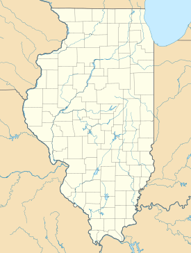
 OttawaFreeportJonesboroCharlestonGalesburgQuincyAlton
 SpringfieldChicagoLocations in Illinois where Lincoln and Douglas debated. Green denotes debates between Lincoln and Douglas while purple denotes places where they spoke separately within a day of each other.

New map and area of Nepal
Your input is requested at Wikipedia talk:WikiProject Nepal#New map and area of Nepal. Thank you! Usedtobecool ☎️ 10:38, 22 May 2020 (UTC)
Splitting proposal at Charding Nullah
Hi, there is a proposal here to split part of the article on the river Charding Nullah into a new article called Demchok dispute. Any input is appreciated! — MarkH21talk 16:56, 29 May 2020 (UTC)
Public transportation mapping article in The Signpost
I thought this would be of interest to members of this wikiproject. Please post comments in the talk section of that article. Thanks! Blue Rasberry (talk) 12:48, 1 June 2020 (UTC)
Location map of Australia and New Zealand
I am trying to create location maps for articles on chains of volcanoes, for example Tasmantid Seamount Chain. These would show a few (perhaps 10) geographic features and an overlay showing a path. I have mocked up a map using Template:Location map+ with Module:Location map/data/Australia and New Zealand with image_overlay Commons:File:Tasmantid seamount track overlay.svg. See User:Billingd/maps if you want some background. It sort of works. The features can be hyperlinks, which I like. It was quite easy to create the overlay in Inkscape and export it as a .svg image.


My problem is that the locations plotted on the base map are wrong. Here is a simple test case. Cape Howe and Point Danger are actually where the state borders meet the coast. They are shown about 200 km south of the true positions. Very wrong!!
I have read the notes on the base map Commons:File:Map of Australia and New Zealand.png, derived from Commons:File:AustraliaNZ-blank.png. I suspect the (unstated) map projection doesn't match the requirements of the Location template. Not sure what to do.
The existing map Commons:File:Australasia_and_South_Pacific_locator_map.svg could serve as a base map, if it was suitable. I would need someone to help me to set up a Location map+ template. Is a map using Spherical Mercator projection usable. If so, what is the function that maps coordinates to image locations? This covers more area than desirable, and crosses the 180th meridian, so another map may be a better solution.
Billingd (talk) 14:13, 11 July 2020 (UTC)
I see that map Commons:File:South East Australia and New Zealand locator map.png is used for it:Template:Mappa di localizzazione/Australia sudorientale e Nuova Zelanda. The results in it:Coppa del Mondo di rugby 1987 look OK. I may be able to get away with that.
Billingd (talk) 14:32, 11 July 2020 (UTC)
Also requested a new map at Wikipedia:Graphics_Lab/Map_workshop.
Billingd (talk) 03:43, 12 July 2020 (UTC)
pushpin map suggestion via coordinate on page
I'm working on WP:LAKES and we recently created a maintenance category to get an idea of how many lake infoboxes lacked a pushpin map. Turns out it is a lot with over 10,000 since the infobox field is new. One of the questions I have in trying to look at solutions for tackling this is are the maps used as pushpin maps georeferenced in any way? I'm thinking a shapefile that a coordinate could be computed if it is within the shape file and return a list of suggested maps to select for the infobox display or page. If so we could either add maps with a bot batches with human review or with a semi-automated tool to assist a human editor, but I wasn't sure if this has been proposed or done before. Wolfgang8741 says: If not you, then who? (talk) 07:52, 13 July 2020 (UTC)
Help merging files into a unified map?
.png)
_01.png)
.svg)
I'd like to merge the three files here into one unified map, but my graphics skills are not up to the task. (I recognize that there will be visible lines between the scans, which are of highly different quality; that's OK with me.) Is there anybody here that could give me a hand? (For now, this is for a Wikisource transcription, but it may be useful on Wikipedia as well, e.g. for History of Oregon.) -Pete Forsyth (talk) 17:17, 16 July 2020 (UTC)
Improvements to TomTom article
Hello, I'm Murley,
An employee of TomTom, here on behalf of the company to request changes to the article under the guidelines for editors with a conflict of interest. As a paid employee, I will never edit the article myself.
I left a more detailed note on the TomTom Talk page, but in short, I'm hoping an editor can review my request to trim the article of excess technical and unsourced information that is susceptible to deletion. I'm happy to answer any questions or approach differently, if editors prefer. Thank you! Murley from TomTom (talk) 10:50, 24 July 2020 (UTC)
One of your project's articles has been selected for improvement!
 Hello, |
Is there an easier way?
Looking at something like File:WorldMap.svg , I'm wondering if there's a way to shade in some countries via code? Perhaps via classes in SVG/CSS?
Looking at the use case in Farenheit (image "Countries that use Fahrenheit"), is there any way to be able to include such an image merely by listing the countries? it would be so much better if this was auto-created, rather than having to generate a separate image for lots of different cases (and then update each one if there is a border change in the future). — Preceding unsigned comment added by 92.71.17.254 (talk) 15:36, 2 October 2020 (UTC)