
Wikipedia:Graphics Lab/Map workshop/Archive/Sep 2011
Stale[edit]
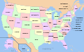
New NJ pages[edit]
Hi. Would anybody be willing to help out on these pages: Sandtown, New Jersey, Mizpah, New Jersey, Richwood, New Jersey, Cedar Brook, New Jersey, Phalanx, New Jersey, Georgia, New Jersey, Siloam, New Jersey, Smithburg, New Jersey, Millhurst, New Jersey, New Brooklyn, New Jersey, Tansboro, New Jersey, Evesboro, New Jersey, Jacksonville, New Jersey, Jacobstown, New Jersey, and Blue Anchor, New Jersey. I do not know how to add the map pin-point thing in that info box to the right like on this page: Tennent, New Jersey. thanks. Tinton5 (talk) 00:28, 2 July 2011 (UTC)
|
|
Thank you very much for the help. Tinton5 (talk) 19:20, 2 July 2011 (UTC)
Resolved[edit]
Four-color map of the United States edit[edit]
-
 Map of the United States with four colours
 -
 Map of the United States with four colours and no names


Article(s): Four color theorem
Request: Please can you remove the text from the image. Peter (talk) 18:48, 26 August 2011 (UTC)
Graphist opinion(s):
![]() Done. The scale could also be removed as could Canada and Mexico. Derfel73 (talk) 20:01, 26 August 2011 (UTC)
Done. The scale could also be removed as could Canada and Mexico. Derfel73 (talk) 20:01, 26 August 2011 (UTC)
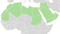
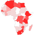
Maps missing South Sudan[edit]
-
 Sub-Saharan Africa iron age
 -
 Sub-Saharan Africa climate map


Article(s): Sub-Saharan Africa
Request: South Sudan became an independent state a few months ago and is missing on these two maps. Please can you edit in South Sudan? Thanks Peter (talk) 19:50, 29 August 2011 (UTC)
Graphist opinion(s): This has been covered previously. Please place these maps in the appropriate category by putting [[Category:Maps needing South Sudan political boundaries]] at the bottom of each image's page. -MissMJ (talk) 06:00, 31 August 2011 (UTC)
Kingdom of Hawaii – Kingdom of Tahiti relations MAP[edit]
-
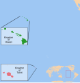 Locator map

Article(s): User:KAVEBEAR/Kingdom of Hawaii – Kingdom of Tahiti relations
Request: I need a map Locating the Kingdom of Hawaii (all eight islands of Hawaii and the Northwestern isles) and the Kingdom of Tahiti (only Tahiti, Moorea, Tetiaroa, and Mehetia). Probably if possible not a world map due to the two nations small area. KAVEBEAR (talk) 07:37, 28 August 2011 (UTC)
Graphist opinion(s):
![]() Done. I hope the map is satisfactory; there were obvious issues of size and distance, so most of the map is water. Derfel73 (talk) 22:47, 1 September 2011 (UTC)
Done. I hope the map is satisfactory; there were obvious issues of size and distance, so most of the map is water. Derfel73 (talk) 22:47, 1 September 2011 (UTC)
- I think you left out the two other islands of the Kingdom of Tahiti, Tetiaroa and Mehetia which you can see in this map of the Society Islands?
An easy map for a FAC[edit]


Article(s): Fomitiporia ellipsoidea
Request:Could someone please create a map, preferably based on File:China blank map.svg, with 27°03′N 118°08′E marked in one colour, and 18°440′295100′′-18°440′295300′′N, 108°500′433500′′-108°500′433500′′E marked in another? It's for Fomitiporia ellipsoidea- the first location is where the fungus was first found, and the second is where a giant fruit body was found. The locations should correspond with these, but be more specific. Thanks! J Milburn (talk) 15:39, 29 August 2011 (UTC)
Graphist opinion(s):
I have added the first location to a location map; for the second, are you requesting a rectangle with the four coordinates given, as corners? Derfel73 (talk) 10:23, 31 August 2011 (UTC)
- I'm sorry, I'm really not sure- it's just a string of numbers and letters to me. The coordinates were given as a single location- the location of the discovery. Perhaps the center of the rectangle? J Milburn (talk) 19:14, 1 September 2011 (UTC)
WAGGGS/South Sudan[edit]
-
 color South Sudan orange
 -
 border South Sudan and color grey


Article(s): WAGGGS
Request: Color South Sudan orange... Kintetsubuffalo (talk) 04:12, 2 September 2011 (UTC)
Graphist opinion(s):
![]() Done Derfel73 (talk) 07:49, 2 September 2011 (UTC)
Done Derfel73 (talk) 07:49, 2 September 2011 (UTC)
- Thank you so much!--Kintetsubuffalo (talk) 13:43, 2 September 2011 (UTC)
Great Egg Harbor Bay in New Jersey[edit]

Article(s): Great Egg Harbor Bay
Request: Could someone create a map of this large bay? Much appreciated. Tinton5 (talk) 16:34, 31 August 2011 (UTC)
Graphist opinion(s):
What exactly do you mean by 'map'? One could use a satellite image like this or a map like this (both are from the USGS and therefore in the public domain, if I understand it correctly), or a map could be made in the style of your choosing. Derfel73 (talk) 11:52, 1 September 2011 (UTC)
- Yeah, a map showing the bay and general area. That second link looked nice. I was wondering if the Great Egg Harbor Bay is the same as the Great Egg Harbor? Tinton5 (talk) 16:49, 1 September 2011 (UTC)
- I am not sure if this map is allowed, probably not...but it makes it clear where the bay is exactly -- [1] Tinton5 (talk) 16:54, 1 September 2011 (UTC)
![]() Request taken by Derfel73.; I'll make a map similar to the one you suggested. Derfel73 (talk) 22:52, 1 September 2011 (UTC)
Request taken by Derfel73.; I'll make a map similar to the one you suggested. Derfel73 (talk) 22:52, 1 September 2011 (UTC)
- The name of surrounding towns, the Atlantic Ocean and other surrounding bodies of water would do the trick. Tinton5 (talk) 01:09, 3 September 2011 (UTC)
 Done. I hope this is acceptable. Derfel73 (talk) 20:19, 3 September 2011 (UTC)
- It looks great! Thanks! One thing - is it possible to correct the spelling of Skul Bay to "Skull" Bay? Tinton5 (talk) 05:14, 4 September 2011 (UTC)
- Done. The map can probably be added to a bay infobox template.Derfel73 (talk) 11:41, 4 September 2011 (UTC)
- It looks great! Thanks! One thing - is it possible to correct the spelling of Skul Bay to "Skull" Bay? Tinton5 (talk) 05:14, 4 September 2011 (UTC)
- The name of surrounding towns, the Atlantic Ocean and other surrounding bodies of water would do the trick. Tinton5 (talk) 01:09, 3 September 2011 (UTC)
Article(s): Amtrak
Request: The previous map in this article was recently deleted, due to it apparently being a copyright violation. The article now lacks a map of the Amtrak system. Is there anyone here who would be willing to take on this challenge? The official Amtrak system map can be found here. Thanks! –BMRR (talk) 21:05, 4 September 2011 (UTC)
- 000peter added a German version of the Amtrak system map to the article (thank you!), which is certainly better than having no map at all, but it's a bit outdated, the distance legend uses kilometers instead of miles, and, well, it's weird to be reading the English language Wikipedia and see German words on a map of the U.S. ;-) So, the situation isn't quite as urgent as before, but a new map would still be greatly appreciated. Thanks, BMRR (talk) 22:47, 4 September 2011 (UTC)
Graphist opinion(s):
![]() Request taken by Pi.1415926535. It's an SVG so I can modify it. Should be pretty easy. Pi.1415926535 (talk) 23:34, 4 September 2011 (UTC)
Request taken by Pi.1415926535. It's an SVG so I can modify it. Should be pretty easy. Pi.1415926535 (talk) 23:34, 4 September 2011 (UTC)

- Done and replaced. Pi.1415926535 (talk) 23:59, 4 September 2011 (UTC)
[edit]
-
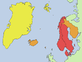 Map of Scandinavia
 -
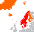


Article(s): Scandinavia
Request: Please can you recreate a vector version of the map above using the resource: File:Location European nation states.svg. However, please can you omit Greenland from the map (as it isn't a Scandinavian country) and change Svalbard from yellow into orange; leaving only red and orange definitions on the map. Also, can you obviously crop the resource around Scandinavia/Northern mainland Europe. Thank you very much! Peter (talk) 20:01, 4 September 2011 (UTC)
Graphist opinion(s):
![]() Request taken by Wereldburger758.. I made the map but what do the colours mean? It is important otherwise I cannot finish the map. Wereldburger758 (talk) 13:29, 8 September 2011 (UTC)
Request taken by Wereldburger758.. I made the map but what do the colours mean? It is important otherwise I cannot finish the map. Wereldburger758 (talk) 13:29, 8 September 2011 (UTC)
- the most common usage: the three monarchies; Denmark, Norway and Sweden
![]() Done. If you want something changed, let me know. Wereldburger758 (talk) 16:53, 8 September 2011 (UTC)
Done. If you want something changed, let me know. Wereldburger758 (talk) 16:53, 8 September 2011 (UTC)
International recognition of Abkhazia and South Ossetia[edit]
-
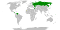 Countries that have recognised of Abkhazia and South Ossetia

Article(s): International recognition of Abkhazia and South Ossetia
Request: Add a green dot for Vanuatu, who recognised Abkhazia (sources in article). Maybe a lighter green should be used, as Vanuatu has not recognised both entities. Thanks Zangar (talk) 17:28, 5 September 2011 (UTC)
Graphist opinion(s):
![]() Done Derfel73 (talk) 16:38, 10 September 2011 (UTC).
Done Derfel73 (talk) 16:38, 10 September 2011 (UTC).
Zagreb bypass map[edit]
-
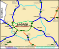 Current PNG map of planned Zagreb bypass (not accurate)
 -
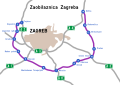 Another map of satisfactory accuracy


Article(s): Zagreb bypass
Request: Would it be possible to create a new map in SVG using image map available at this site. The map there may be zoomed and is quite large. Besides it is much more accurate than currently available on the wiki. I expect a considerably simplified map akin to currently available PNG would be quite sufficient. Thanks!--Tomobe03 (talk) 21:58, 20 July 2011 (UTC)
- Additional note: Apparently there is now another map of satisfactory accuracy, so this request may be closed.--Tomobe03 (talk) 13:36, 12 September 2011 (UTC)
Graphist opinion(s):
File:Saffron crocus sativus modern world production.png[edit]
Wereldburger758 (talk) 04:46, 15 September 2011 (UTC)


Article(s):
Request:
Picture depicts: A world maps shading countries and subnational regions by contribution to world saffron harvest. I created map mainly from Willard 2001 ("Secrets of Saffron: The Vagabond Life of the World's Most Seductive Spice") listed at the saffron pages, but is not on the image page. Book discussed, by continent, saffron production and the relative importance of various regions. I inadvertently created a POV map by assuming all significant Kashmiri production took place in Indian-occupied Vale of Kashmir, but this territory is disputed.
I'd be grateful for the following:
- SVG-ify the map.
- Shade the non-disputed (non-Kashmir) parts of Pakistan and India the same color as China is now (light red).
- Make all of Kashmir (the dark-red disputed region) same color as Italy (red).
Thanks. Saravask 20:34, 11 September 2011 (UTC)
Graphist opinion(s):
![]() Done Wereldburger758 (talk) 13:06, 17 September 2011 (UTC)
Done Wereldburger758 (talk) 13:06, 17 September 2011 (UTC)
![]() Request taken by Wereldburger758.
Request taken by Wereldburger758.
- Excellent. Thanks! Saravask 01:45, 13 September 2011 (UTC)
PA 2010 U.S. House of Representatives Elections[edit]
Wereldburger758 (talk) 05:35, 19 September 2011 (UTC)
-
 U.S. House Elections Map
 -
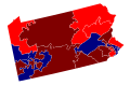 U.S. House Elections Map Pennsylvania.svg
 -
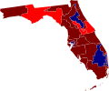 U.S. House Elections Map Florida
 -
 U.S. House Elections Map Alaska
 -
 U.S. House Elections Map Hawaii
 -
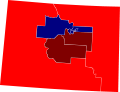 U.S. House Elections Map Colorado
 -
 U.S. House Elections Map Idaho
 -
 U.S. House Elections Map Kansas
 -
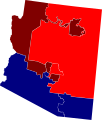 House Elections Map Arizona
 -
 U.S. Elections Map California
 -
 U.S. Elections Map Maine
 -
 U.S. Elections Map Massachusetts


Article(s): United States House of Representatives elections in Pennsylvania, 2010
Request: Hi. Could someone please crop the full country map to Pennsylvania and then enlarge its default size so we can see the results for Pennsylvania. If you're super motivated it'd be great to do this for all 50 States to go in all the state House elections in 2010. gren グレン 18:34, 16 September 2011 (UTC)
Graphist opinion(s):
![]() Request taken by Wereldburger758.
Request taken by Wereldburger758.
- More states to follow. Wereldburger758 (talk) 12:01, 17 September 2011 (UTC)
- I mistakenly called Pennsylvania Virginia. The map can be used though. I'll put a rename request on the page. Wereldburger758 (talk) 04:28, 18 September 2011 (UTC)
- The renaming is already done.Wereldburger758 (talk) 05:28, 18 September 2011 (UTC)
- I mistakenly called Pennsylvania Virginia. The map can be used though. I'll put a rename request on the page. Wereldburger758 (talk) 04:28, 18 September 2011 (UTC)
![]() Done Wereldburger758 (talk) 12:53, 17 September 2011 (UTC)
Done Wereldburger758 (talk) 12:53, 17 September 2011 (UTC)
- Thanks! They look great. gren グレン 01:25, 19 September 2011 (UTC)
- As I'm looking through and using your images I noticed that at least one state already had this done (California File:CA2010House.svg). I'll check other states to see if there are others that were previously done. gren グレン 15:38, 20 September 2011 (UTC)
- Thanks! They look great. gren グレン 01:25, 19 September 2011 (UTC)
Incorrect translation[edit]
Wereldburger758 (talk) 13:59, 22 September 2011 (UTC)
-
 Map of Zurich area

Article(s): Zurich
Request: "Thurgovie" is "Thurgau" in English. 212.41.117.234 (talk) 09:14, 17 September 2011 (UTC)
Graphist opinion(s):
![]() Done Wereldburger758 (talk) 12:52, 17 September 2011 (UTC)
Done Wereldburger758 (talk) 12:52, 17 September 2011 (UTC)
Quick fixes needed[edit]
Wereldburger758 (talk) 14:24, 25 September 2011 (UTC)
-
 I need to remove the title in the top right corner, the legend on the left, and if possible, I need to remove the text as it was rendered incorrectly.
 -
 I just need the scale to be removed.
 -
 Names removed.


![[1]](http://www.state.nj.us/dep/bmw/sondepages/sondeimages/GreatEggHarbor.jpg)
Article(s): List of World Heritage Sites in Africa
Request: I'm in the process of an FLC and a reviewer wanted the above changes done, but I'm terrible with SVGs, so I reluctantly have to ask for your help. Thanks in advance. EricLeb01 (Page | Talk) 23:09, 21 September 2011 (UTC)
Graphist opinion:
![]() Request taken by Wereldburger758 (talk) 06:47, 22 September 2011 (UTC).
Request taken by Wereldburger758 (talk) 06:47, 22 September 2011 (UTC).
- Do you want the new files overwritten or uploaded separately? Pi.1415926535 (talk) 01:00, 22 September 2011 (UTC)
- Overwritten. I have no use for the older versions. Thanks. EDIT: Actually, if possible, maybe keep the first image intact, as it isn't mine. EricLeb01 (Page | Talk) 01:27, 22 September 2011 (UTC)
- Do you want all the text removed in the first picture or do you want the text in a different font? Be more specific please. Wereldburger758 (talk) 06:47, 22 September 2011 (UTC)
- I want the text removed completely. As in, the only thing left are the dots, the map, and the colours. Everything else needs to be gone. Thanks. EricLeb01 (Page | Talk) 12:04, 22 September 2011 (UTC)
- Uploaded a new map, edited the second map, as requested. Wereldburger758 (talk) 13:10, 22 September 2011 (UTC)
- I want the text removed completely. As in, the only thing left are the dots, the map, and the colours. Everything else needs to be gone. Thanks. EricLeb01 (Page | Talk) 12:04, 22 September 2011 (UTC)
- Do you want all the text removed in the first picture or do you want the text in a different font? Be more specific please. Wereldburger758 (talk) 06:47, 22 September 2011 (UTC)
- Overwritten. I have no use for the older versions. Thanks. EDIT: Actually, if possible, maybe keep the first image intact, as it isn't mine. EricLeb01 (Page | Talk) 01:27, 22 September 2011 (UTC)
![]() Done Wereldburger758 (talk) 13:09, 22 September 2011 (UTC)
Done Wereldburger758 (talk) 13:09, 22 September 2011 (UTC)