
Wikipedia:Graphics Lab/Map workshop/Archive/Jul 2014
| This page is an archive. Do not edit the contents of this page. Please direct any additional comments to the current main page. |

Request fot modifying Andhra Pradesh map locator.svg
![]() Not done
Not done
-

-
Description of second image (if needed)
-
Description of third image (if needed; don't request too many at once, though)

Article(s): Andhra Pradesh
Request:
- Recently 7 mandals are added to AP, hence there is small correction. Reference please see this page, there is small addition near West Godavari district.-- Vin09 (talk) 13:57, 16 July 2014 (UTC)
Graphist opinion(s):
- Hi Vin09. The issue with making such changes is that this map is an orthographically correct projection of the area based on OpenStreetMap coordinate data (I know that because I created it). That means that making changes isn't a question of drawing/altering a few lines, they need to be in the right place and accurately reflect their geocoordinate position. The source you have provided gives no indication of the requisite positional data so I'm reluctant to change the map until the underlying source (i.e.OpenStreetMap) shows the changes too. Best, Philg88 ♦talk 05:24, 17 July 2014 (UTC)
Roman

Article(s): Roman
Request:
- remove "the" before Southern... -- Kintetsubuffalo (talk) 10:39, 18 July 2014 (UTC)
Graphist opinion(s):
 Done Maproom (talk) 12:27, 18 July 2014 (UTC)
- Thank you!--Kintetsubuffalo (talk) 23:14, 19 July 2014 (UTC)
Commonwealth Games - Gambia and Fiji

Article(s): Commonwealth Games
Request:
- Gambia left the Commonwealth on 3 October 2013, and hencefore no longer competes at the Commonwealth Games. Would someone please colour it in green on the above map to reflect that. And another thing, Fiji's suspension from the Commonwealth was partially lifted in March 2014, in time for the current 2014 Commonwealth Games, at which Fiji is currently competing. So Fiji needs to be coloured in red to reflect the fact that it now competes at the Games again.
Graphist opinion(s):
Russo-Georgian war
-
 This image serves as the base for a new map.
 -
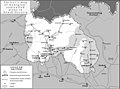
 Knowledge of German is required. The areas in Abkhazia and adjacent Georgian territory.
 -
 Polish map. The borders are the most accurate here, but the quality is low. It can be combined with Spanish map.
 -
 International Crisis Group (ICC) map.
 -
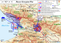 Current article map


Article(s): Russo-Georgian War, Background of the Russo-Georgian war
Request:
- The map is needed for the article to show the areas controlled by Georgia before 2008. First image is to be edited and the areas of the separatist enclaves controlled by Georgia shown in different colors. The symbol of Globe and the frame around the map must be removed. I don't have the knowledge of either German or Spanish but I guessed some things.
- The areas in Abkhazia (Abchasien on the map) controlled by Georgia and UN is shown on German map. UN controlled area must be shaded in the same style on the new map as it is on the German one and show the exact borders. Another map for verification is here in this source: ABKHAZIA TODAY, Europe Report N°176 – 15 September 2006, p. 27
- Spanish map depicts the situation in South Ossetia more accurately than German map. There are areas in different green colors on the map and both supposedly show the Georgian-governed territories, so therefore both should be combined into single colored area. But Polish map seems to have more accurate South Ossetian-Georgian boundaries. There are some areas (in light green) on Spanish map that are not shown on the Polish and ICC maps. These areas are not to be taken into consideration. --UA Victory (talk) 17:51, 11 April 2014 (UTC)
Graphist opinion(s):
- It would be great if you signed your request, I don't think many will work on it without knowing who requested it, anyway that goes for me, thanks. --Goran tek-en (talk) 17:28, 11 April 2014 (UTC)
- Sorry, I have now signed my request. This is the first time I requested a Graphics work done and the blank where I had to fill in all the details, I forgot it.--UA Victory (talk) 18:55, 11 April 2014 (UTC)
 Request taken by Goran tek-en (talk) 18:24, 25 April 2014 (UTC).
- UA Victory I have taken this request and I will gladly do it. It will take a week or maybe two before I can start to work on it. If that doesn't work for you just tell me and then maybe someone else can do it faster than that, it's all up to you, thanks. --Goran tek-en (talk) 18:24, 25 April 2014 (UTC)
- Actually, I will gladly wait until the map is made. --UA Victory (talk) 18:36, 25 April 2014 (UTC)
- Sorry, I have now signed my request. This is the first time I requested a Graphics work done and the blank where I had to fill in all the details, I forgot it.--UA Victory (talk) 18:55, 11 April 2014 (UTC)
UA Victory So now I have started to work on your map. You can look at a draft here. Look at it and tell me if it's something you want. This map is a svg file so it should be easier to change it in the future.
I'm not sure I have understood you totally so just tell me what you want changed/removed or other ideas, thanks. --Goran tek-en (talk) 18:39, 13 May 2014 (UTC)
- Goran tek-en This is a good draft, and I like the graphics, but it lacks some details. Where are the cities and towns? They were perfectly depicted on the base map. Can you convert the base map to SVG and combine it with your draft?
- The caption for Georgia should be moved to the right, just under South Ossetia and the river. The captions for Abkhazia and South Ossetia on your draft should be smaller and lighter in color (grey).
- The light yellow area (territory controlled by Georgia) in Abkhazia is called Kodori Gorge. The colors for areas in South Ossetia should be inverted. The area controlled by South Ossetian separatists should be shown in green.
- Georgian administrative divisions except Ajaria are not needed to be depicted on your draft. Georgian-Abkhaz and Ajarian borders are better suited with the same type of Autonomous republic boundary style as on the base map. South Ossetian border with Georgia is to be shown with the same type of boundary as the administrative divisions on your current draft.
- As for the legend, Demilitarized zone should be changed to Restricted weapons zone (RWZ), UN controlled area to UN Security zone (SZ) and the color code for Controlled by Georgia should be switched to light yellow. --UA Victory (talk) 12:29, 19 May 2014 (UTC)
UA Victory When I do graphic work like this i try not to do a lot of work which is not needed, therefore I don't put in to much information=work to start with which I eventually have to discharge later on, I do have other things in life. Also, this is the requestors subject which I as a graphist have zero or very little knowledge about, bear that in mind. I'm all for constructive feedback but I don't appreciate smart comments on the work or what I should have understood as you see it.
What is, as you write "perfectly depicted on the base map" is not all that clear to someone who knows nothing of the subject or what final map image you alredy have in your mind, how can I know that. There are also a lot of other things in the map, roads, railroads and so on. Should that also be included in the map, it's not all that clear.
- Now there is a new draft, reload the page for the new version for you to look at.
- Regarding the boundary styles I stick to what is suggested in "Maps_template-en.svg", the reason for this is that maps more or less should look the same and therefore work together better thru out Wikimedia.
- Give me constructive feedback on this, thanks. --Goran tek-en (talk) 19:04, 21 May 2014 (UTC)
- Goran tek-en Thank you for your understanding and patience. However the draft still needs some tweaking. You don't have to worry about the roads and other stuff, the towns are sufficient for the readers to understand who controlled what. What I meant by "perfectly depicted on the base map" that before I saw your draft, I thought that you would edit the base map and add in these colour areas that I requested. I did not expect that you would recreate the map from zero with your graphic style. That's fine, I like your style.
- I looked at "Maps_template-en.svg". The administrative boundaries of Ajaria and Abkhazia within Georgia should be like "Province / Region" shown on the template.
- The labels - Kvasi, Tsalenjhikha, Bakhamro and zurgeti are erroneous. Instead, they should be labeled as Kvaisi, Tsalenjikha, Bakhmaro and Ozurgeti.
- Overall, the several towns look misplaced because the rivers look somewhat different from the base map. The problematic towns are Ambrolauri, Zestaponi, Chiatura and Chokhatauri. On the base map they are located on the river. Please try moving the circle symbols to the north, near the rivers.
- Please correct the locations of these towns after visually comparing to the base map: Pitsunda (move to more south-western location), Anaklia (to southern location, the inside of the circle denoting the town should be yellow, Abkhaz border near here also needs some correction as it runs on the north of the river), Batumi (to the northern direction, on the cape), Tskhinvali (the inside of the circle symbol should be green as it was controlled by the separatists), Akhalgori (on the other maps that I gave for reference, the town seems to be in the centre of the Georgian controlled territory, so the circle should be moved to the right), Gori (a bit to the north, right on the river), and Rustavi (the circle should be moved to the left, on the side of the river).
- After all this, the map should almost be ready. --UA Victory (talk) 20:35, 21 May 2014 (UTC)
- UA Victory To me it's very seldom worth the trouble to edit a bitmap (png, jpg) instead of creating a vector (svg) image that is so much easier to edit later on and the usage is so much greater in many ways.
- Sorry that I didn't see the issues with the cities before. New version reload the page for the new version for you to give me feedback on, thanks. --Goran tek-en (talk) 19:46, 22 May 2014 (UTC)
- Goran tek-en The circle symbol denoting Ozurgeti is too large compared to other towns. Also the circle for Zestaponi should be moved a bit lower, right by the side of the river. However the misplacement of the rivers still disturb me. Can you correct the rivers according to the standard WP map as it seems more accurate, especially because the easternmost borders are demarcated along the rivers, please? --UA Victory (talk) 20:27, 22 May 2014 (UTC)
- Goran tek-en Thank you for your understanding and patience. However the draft still needs some tweaking. You don't have to worry about the roads and other stuff, the towns are sufficient for the readers to understand who controlled what. What I meant by "perfectly depicted on the base map" that before I saw your draft, I thought that you would edit the base map and add in these colour areas that I requested. I did not expect that you would recreate the map from zero with your graphic style. That's fine, I like your style.
UA Victory That is exactly the base map I'm using so there is nothing to be changed what concern the rivers location. There is a difference between your original map and this base map and that has to be changed by hand. I have changed Ozurgeti and Zestaponi but whatever else that has to be changed is all by hand on your instructions. new draft, reload the page for the new version --Goran tek-en (talk) 19:29, 23 May 2014 (UTC)
- Goran tek-en The circle for Ozurgeti has to move to southwest. As for the rivers, overlay your draft on top of this standard WP map or compare them side by side and you'll see the cause of my concern. Look at both the rivers and the state borders near DedoplisTsqaro on both your draft and WP template. --UA Victory (talk) 20:17, 23 May 2014 (UTC)
- UA Victory The problem is that there is a differnce in the maps concerning the rivers and scale. I did try to adjust for that before but obviously I didn't succeed, I'm sorry for that. It's very good that you tell me so I can correct it, thanks.
- I have now (again) tried to combine the maps in spite of the differences. I'm sorry but you would have to check the citys again, new draft, reload the page for the new version, thanks. --Goran tek-en (talk) 17:28, 25 May 2014 (UTC)
- Goran tek-en There is huge white shade behind the label for Zestaponi when highlighted that should be removed. Tqvarcheli is located a bit lower than the latitude Gulripsh is on the base map. Senaki is located a bit lower than Khobi on the base map. Move Bakhmaro a bit upper. Move Keda a bit lower, on the side of the river. Move Khashuri a bit lower, on the side of the river. Move Mleta in the direction of NNW, just under the river. Move Pasanauri a bit upper above the South Ossetian border.--UA Victory (talk) 21:25, 25 May 2014 (UTC)
- UA Victory The problem is that there is a differnce in the maps concerning the rivers and scale. I did try to adjust for that before but obviously I didn't succeed, I'm sorry for that. It's very good that you tell me so I can correct it, thanks.
- Goran tek-en The circle for Ozurgeti has to move to southwest. As for the rivers, overlay your draft on top of this standard WP map or compare them side by side and you'll see the cause of my concern. Look at both the rivers and the state borders near DedoplisTsqaro on both your draft and WP template. --UA Victory (talk) 20:17, 23 May 2014 (UTC)
UA Victory new draft, reload the page for the new version. When we eventually are done I would need a new name for the map because I can't have the same as on the bitmap image. I will reuse description and categorys if you don't give other information. Get back to me thanks. --Goran tek-en (talk) 13:20, 26 May 2014 (UTC)
- Goran tek-en Move Mleta a bit upper, above the border. Rename T'bilisi to Tbilisi.
- Please have a look at International Crisis Group (ICC) map and see the white area around Khetagurovo on the left of Tskhinvali. The relevant green area on your draft should be extended to the boundary.
- After this, the work should be finished. The name will be "Georgia before August 2008". When you will upload the map to Wikipedia, in the source section write in those maps that I gave for reference and also this ABKHAZIA TODAY, Europe Report N°176 – 15 September 2006, p. 27. --UA Victory (talk) 14:15, 26 May 2014 (UTC)
- UA Victory Mleta is supposed to be south of the river according Georgia_high_detail_map.png so is this OK?
- Is this what you wanted around Khetagurovo?
- It's not exactly the same as for the spanish and polish maps which you provided as source so it's really hard to know which one to go by. Please don't give me options, tell me what to pick from which map and I will try to adjust for different proportions as almost all map has. New draft, reload the page for the new version. --Goran tek-en (talk) 18:14, 26 May 2014 (UTC)
- Goran tek-en Yes, Mleta now is OK. As for the area around Khetagurovo, it is delineated on Spanish map, but it's unclear on Polish one because the huge label sits on top of it. You are right, I should have explained more explicitly.
- Move the circle of Chokhatauri below right on the side of the river. Rename Tskhaltubo to Tsqaltubo. Move the label for Bakuriani below the circle, because it sits too close to the label for Georgia.
- The little green area between Kurta and Tskhinvali looks smaller compared to previous draft. Can you re-extend it to the border like it is on both Spanish and Polish maps?
- Move the circle of Tskhinvali a bit on the right so the river flows through the circle. The label should be placed under the circle and the border so the area around it remains visible. The area between the circle and the border (where now the symbol "T" stands) should be yellow like it is demarcated on both Spanish and Polish maps.--UA Victory (talk) 19:37, 26 May 2014 (UTC)
- UA Victory New draft, reload the page for the new version. --Goran tek-en (talk) 14:12, 27 May 2014 (UTC)
- Goran tek-en Move Ozurgeti to Northwest on the same longitude as Lanchkhuti.
- Move around the labels for Tqibuli and Kutaisi (a bit below), and Khvanchkara (on the right) so they don't overshadow the rivers.
- Correct the South Ossetian boundary line below Kurta per the standard WP map --UA Victory (talk) 15:17, 27 May 2014 (UTC)
- UA Victory New draft, reload the page for the new version. --Goran tek-en (talk) 14:12, 27 May 2014 (UTC)
- UA Victory Mleta is supposed to be south of the river according Georgia_high_detail_map.png so is this OK?
UA Victory New draft, reload the page for the new version. --Goran tek-en (talk) 10:07, 28 May 2014 (UTC)
- Goran tek-en To me it seems that now all towns are OK. The work on towns is finished.
- The area between the labels for Tskhinvali and South Ossetia on your draft will be better if changed according to the International Crisis Group map. Otherwise it would be consistency problem. It seems that ICC map is the source for the the current article map. The small green area on your draft, on ICC map it is connected to the separatist-held territory and doesn't extend to the border.
- I found out that the Kodori gorge area on German map that I gave for reference is not the same as on the current article map. I tried to make an example in Paint what I mean here near Tqvarcheli. I found Wikimapia map of Kodori Gorge that gives the most accurate boundaries. Can you overlay your draft over Wikimapia map and change the area accordingly, please?
- After all this, I suspect that German map should not be used as the base. Please, create the copy of your draft and delineate on it the RWZ like here ABKHAZIA TODAY, Europe Report N°176 – 15 September 2006, p. 27. Please, show both versions here. --UA Victory (talk) 11:31, 28 May 2014 (UTC)
- UA VictoryThe ICG map and Georgia_location_map.svg does not have exactly the same border and the rivers are different also for South Ossetia. That makes it hard to get everything right and it probably has to be adjusted based on your knowledge of the area.
- There are more differences between wikimapia and the draft but I didn't change that.
- The link on the text "ABKHAZIA TODAY, Europe Report N°176 – 15 September 2006, p. 27" is "176_abkhazia_today.ashx" which wants me to save something. I don't know what this is so I will not save it on my computer so I can't view it.
- The two versions;
- New draft
- no RWZ --Goran tek-en (talk) 17:44, 28 May 2014 (UTC)
- Goran tek-en It's strange that you could not open this file: ABKHAZIA TODAY, Europe Report N°176 – 15 September 2006, p. 27 I found it on some Wikipedia article. I am using Google Chrome and I did not have any problem viewing it. I took a screenshot of the needed map. Maybe you will use it. I think this is better source for SZ and RWZ than German map. Please don't change the current style of your draft, only boundaries.
- As for Kodori Gorge, I tried really hard and found at last an official government map. See ABKHAZIA BEFORE AUGUST 2008. Can you use it as reference?
- Now South Ossetia area seems almost OK except for the small yellow stripe between Kurta and the left border (from Chiatura to Khashuri). You can remove it (change to green again) because it doesn't appear on other maps.--UA Victory (talk) 18:44, 28 May 2014 (UTC)
- UA VictoryThe ICG map and Georgia_location_map.svg does not have exactly the same border and the rivers are different also for South Ossetia. That makes it hard to get everything right and it probably has to be adjusted based on your knowledge of the area.
UA Victory This is what it looks like when I click on the link. I run Ubuntu 12.04 and chrome, I don't know if that has anything to do with it.
It's amazing that almost every map is slightly different but here are what I think it should be;
- New draft, reload for new version
- no RWZ, reload for new version. --Goran tek-en (talk) 21:23, 28 May 2014 (UTC)
- Goran tek-en Yes, I found it amusing too that every map was different. At least, I think we should rely on official maps because they seem to be more reliable than other (self-made without any source) maps.
- Please don't upload the version without RWZ any more. My previous request was to create another copy of the draft with the RWZ from the official report alongside the draft based on German map. You've already created the new version.
- South Ossetia seems OK to me. I don't think there is any more work to be done now.
- Let's focus now on Abkhazia. Kodori area now seems OK to me.
- However on the official government map Lata is outside the Kodori Gorge. Let's move the circle (should be green) for Lata on the left so it sits between the symbols "a" and "t" right under the label for "Lata".
- Gali is inside the SZ. The circle should be moved lower to southeast so it barely touches the boundary line of SZ from inside. Move Senaki a bit on the right.--UA Victory (talk) 23:42, 28 May 2014 (UTC)
- After comparing the draft to governmental map, several towns need correction.
- Ambrolauri should be moved a bit on the left, under U turn of the river. Samtredia should be moved below, near the confluence of two rivers so the circle sits tight between two rivers (on the same latitude that label for Zestaponi sits). Chokhatauri should be moved a bit on the left. Baghdati should be on the left side of the river. Akhmeta should be a bit lower. Qvareli should be moved a bit lower. DedoplisTsqaro should be moved a bit to southwest. Pasanauri should be moved to southeast by the side of river. Move Mleta a bit to southeast just under the river, but above the border (I know that the circle will be a bit above the river, but that's OK).--UA Victory (talk) 23:42, 28 May 2014 (UTC)
- UA Victory Do you mean that you have uploaded the NO RWZ anywhere?
- That file was not in a final stage and prepared for upload and I want to know and control where my work go. I only accept upload to WikimediaCommons and nothing else. So if you have done anything else you have to undo that and tell me where/what you want uploaded.
- New draft, reload for new version. --Goran tek-en (talk) 11:41, 29 May 2014 (UTC)
- Goran tek-en No, I didn't upload the file anywhere. I simply meant that I don't need such map (without RWZ) and I told you this, so you wouldn't have unnecessary work to do.
- Gali and Lata now are OK.
- However, I did the measurements for location of the towns in Paint. Senaki should be moved a bit on the right (4px) to exactly match the base map for RWZ.
- Move Novyy Afon a bit on the left (4px). Move Otap a bit on the left (8px). Move Lentekhi a bit upper (7px), by the upper side of the river. Move Chokhatauri a bit on the right (8px), by the side of river. Move Keda a bit on the right (5px). Move Tqibuli a bit lower (4px). Move Pasanauri a bit lower, by the side of the river (5px). Move Khvanchkara a bit on the left, by the side of river (3px). Move Archilo a bit below (5px).--UA Victory (talk) 13:57, 29 May 2014 (UTC)
- UA Victory Do you mean that you have uploaded the NO RWZ anywhere?
UA Victory I hope you didn't have another scale or zoom because then eg 4px will be different in my file. New draft, reload for new version. --Goran tek-en (talk) 18:29, 29 May 2014 (UTC)
- Goran tek-en No, the measurements were done on the default scale image. It just worked out OK. This is the final to-do-list for towns and after this, the towns should be done.
- We have to move Chokhatauri a bit lower by the side of river. Move Baghdati a bit on the right so its circle touches the river (1px). Move Pasanauri a bit on the right so its circle barely touches the river. Move Akhaltsikhe a bit upper by the side of the river (its circle should touch the lower side of the river). Akhalkalaki should be moved a bit below, right under the river.
- Please move Tsalenjikha a bit on the right so the circle does not touch UN SZ (9px) like here. Pichori should be moved lower (18px). Move Omarishara a bit on the left (14px), so its circle is by the upper side of the river (barely touches it). Otap has to be moved a bit below (12px), then a bit on the left (8px). Akhalgori should be moved a bit lower (5px), then a bit on the left (7px).
- Tqibuli still has to be moved a bit lower (8px). Move Mestia a bit on the right (3px). Chiatura has to be moved a bit lower (6px), then across the river on the left (11px). Ozurgeti should be moved a bit on the right (14px). Lanchkhuti should be moved a bit on the right (17px). Keda should be moved a bit below (9px), then a bit on the right (3px).
- Move Borjomi to southwest by the side of river (10 px lower latitude). Move Khashuri a bit on the right (7px), by the upper side of river. Bakuriani should be moved a bit lower (22px). Tsnori should be move a bit lower (1px), then on the left (8px). Lagodekhi should be moved a bit below (6px), then a bit on the left (8px). Telavi should be on the same latitude as Qvareli. --UA Victory (talk) 22:38, 29 May 2014 (UTC)
- UA Victory Sorry for my long absence. Your last ping (edit) has not reached me and for about two weeks I have experienced some serious computer/internet problems. But it's all sorted out now and I back with your request.
- Look at this and get back, New draft, reload for new version, thanks. --Goran tek-en (talk) 10:08, 19 June 2014 (UTC)
- Goran tek-en I got worried about you. I am just glad that you are fine.
- The towns are mostly done. However, the white shadow behind Khaishi is a bit misplaced. Keda should be moved a bit on the right (4px). Zugdidi has to be moved on the left (14px), then a bit below (5px).
- Please try to insert the label for the region Adjara (like Abkhazia and South Ossetia) near Batumi, So the labels of cities don't overshadow it.
- It seems to me that Abkhaz border between Pichori and Anaklia and Zugdidi doesn't match the one on the standard WP map. Please try to adjust.
- It would be better if the colour for UN SZ and RWZ zones is changed to light blue like here. Let's try to change this Green color for the separatist areas to another Green like 'Austrian Habsburg' is denoted here. --UA Victory (talk) 13:01, 19 June 2014 (UTC)
- UA Victory I can't find problems with the border "It seems to me that Abkhaz border between Pichori and Anaklia and Zugdidi doesn't match..". I have overlie the maps and I can't find any issue. If you can see some problem you will have to more specific. New draft, reload for new version. --Goran tek-en (talk) 15:00, 20 June 2014 (UTC)
- Goran tek-en Thanks for changing the colors. The map looks nice and clean.
- Keda still has to be moved a bit on the right (5px), then a bit upper (2px) by the side of the river. Gali should be moved a bit lower (3px), then a bit on the right (1px). Tqvarcheli should be moved a bit below (3px), then a bit on the left (3px).
- I have tried to highlight the border problem in Paint and created this comparison. Between Pichori and Anaklia, the border near the sea looks different from the standard WP map. Between Gali and Zugdidi, the border is on the river, while on your draft it runs on the left side of the river. --UA Victory (talk) 16:05, 20 June 2014 (UTC)
- UA Victory I can't find problems with the border "It seems to me that Abkhaz border between Pichori and Anaklia and Zugdidi doesn't match..". I have overlie the maps and I can't find any issue. If you can see some problem you will have to more specific. New draft, reload for new version. --Goran tek-en (talk) 15:00, 20 June 2014 (UTC)
- UA Victory Sorry for my long absence. Your last ping (edit) has not reached me and for about two weeks I have experienced some serious computer/internet problems. But it's all sorted out now and I back with your request.
UA Victory Thanks to your highlight I can see a minor difference and I have now corrected it. New draft, reload for new version. --Goran tek-en (talk) 18:46, 20 June 2014 (UTC)
- Goran tek-en The border along the river is fixed. However, the border between Anaklia and Pichori is still different from WP map. Please try to zoom both your draft and standard WP map side by side and you will see difference.
- Pskhu should be moved a bit upper (5px), then on the left (2px) by the side of the river. Gali should be moved a bit below (2px), then on the right (2px). Tsalenjikha should be moved a bit below (3px), then on the left (1px).
- Khulo should be moved a bit below (4px), then on the right (3px). Abastumani should be moved a bit below (3px), then on the right (1px). Tsqaltubo should be moved a bit below (1px), then on the left (3px). Tqibuli should be moved a bit below (1px), then on the right (5px). Zestaponi should be moved a bit on the left (3px). Chiatura should be moved a bit on the right (1px), then below (2px) by the side of river.
- Ninotsminda should be moved a bit on the left (3px). Dusheti should be moved a bit upper (11px). Qvareli should be moved a bit on the right (6px). Gurjaani should be moved a bit below (1px), then on the left (5px). Tsnori should be moved a bit below (3px), then on the left (8px). --UA Victory (talk) 20:55, 20 June 2014 (UTC)
- UA Victory Now I replaced that section of the border with the one from "the standard map". "We" must have been editing that part at some stage. Did you do your last comment/editing instructions in two parts because I found more instructions when I had been away for a bit. It confused me but it's all done now. New draft, reload for new version. --Goran tek-en (talk) 11:49, 21 June 2014 (UTC)
- Goran tek-en Yes, I did my last instructions in two parts because I had to check all towns again.
- Ochamchira should be moved a bit on the right (1px), then below (1px) so it barely touches RWZ.
- The border is now OK, however minor details need adjustment that I have highlighted here. The yellow areas in the red circles (on the left side of the river) should be green as they are controlled by the separatists.
- Move around the labels for Dusheti (slightly below), Akhmeta (below), Lagodekhi (on the right), Borjomi (on the left), Atskuri (below), Chiatura (below on the other side of the river), Khobi (on the left), Senaki (on the right), Gudauta (on the right), Jvari (above the RWZ) so they won't overshadow the rivers or borders. --UA Victory (talk) 16:29, 21 June 2014 (UTC)
- UA Victory Regarding the minor changes of areas. The areas and the border has exactly the same position. The very small differences that you can find when zooming in is due to the thickness (2.5px) of the border line. If you want this to be changed it has to be manually edited along ALL of the borders, it's the same everywhere.
- I'm not sure that a map like this has that kind of precision or accuracy. As you have seen before all maps has some differences when you compare them as they are more or less edited by hand. It's not that I don't want to create a map that is correct but I don't think people read a map like that and it's NOT practical in any way to edit it like that. Look att the border around South Ossetia, then that should be edited also.
- The reason you see it where you have highlighted it is probably because it runs just up to the river. So I really don't think it's a sensible thing to do.
- What I have done is to add a green line with a thickness of 1.25px and 0.75 px on both of the green areas.
- Some of the labels you mention I have moved differently due to how I think it's most clear to understand which label belongs to the city circle and how the basic structure of the map is best kept. That is all for how the map best can be understood and there are as many ideas as there are people concerning that. I stick to my understanding as far as I think it's OK.
- New draft, reload for new version --Goran tek-en (talk) 18:47, 21 June 2014 (UTC)
- Goran tek-en Thank you for your awesome cooperation. I couldn't imagine that map making was such time-consuming task.
- Finally, I have good news: there are only two towns left that needed exact positioning. Move Gagra on the right (12px), then below (14px). Kurta should be moved a bit on the right (4px), so the river won't be visible under the circle. The label for Khobi should be moved a bit below (2px).
- Now let's move to South Ossetia area.
- I have noticed that some areas don't match the source map (ICC map). I have highlighted my concerns here. I know that the borders are different on ICC map and there was scaling problem. Can you re-adjust it using a grid that I have outlined? Below are the instructions.
- The green area inside the circle B should match the administrative border.
- In the circle 1, the lowest point of the yellow area (inside South Ossetia) is approximately on the same latitude as Tskhinvali on ICC map. This area is also too thick and should not extend past the longitude where the "n" symbol in "Tskinvali" begins.
- In the uppermost part of the red circle 1 the thin yellow area (where the red vertical lines end) that serves as the bridge to northern yellow area, should be moved on the left (to the west of the left red vertical line inside the red circle).
- The green areas on the right of red vertical line inside the circles 2 and 3, should not be there. Their boundary should match the red line.
- The yellow area above the red horizontal line in the circle 4 should not be there. --UA Victory (talk) 09:47, 22 June 2014 (UTC)
- UA Victory Regarding the minor changes of areas. The areas and the border has exactly the same position. The very small differences that you can find when zooming in is due to the thickness (2.5px) of the border line. If you want this to be changed it has to be manually edited along ALL of the borders, it's the same everywhere.
- UA Victory Now I replaced that section of the border with the one from "the standard map". "We" must have been editing that part at some stage. Did you do your last comment/editing instructions in two parts because I found more instructions when I had been away for a bit. It confused me but it's all done now. New draft, reload for new version. --Goran tek-en (talk) 11:49, 21 June 2014 (UTC)
UA Victory
South Ossetia. As you say our borders are different from the ICCmap and making changes are really hard, and to get it "100%" correct is impossible. Also our dots for citys are much larger than on the ICCmap so that is also adding problems. When maps are different (as they are) it's very very difficult to compare and refer to another as the true one.
The geen areas follow the ICCmap to the best of my knowledge despite the different borders and I would have liked to leave it like that, that is my first priority. I will keep a copy of South Ossetia prior to these last changes if we want to revert to that state.
As I trust your local knowledge I will try to make your requested changes but I'm not sure it's the best for the future of this map, how it can be updated and reused.
For 1. When you do like this you get the result that the lowest point is to far to the left compared to the bubble above which was moved towards the right.
For the bridge part in 1. In this way we are changing the shape and widht of the aeras and the bubble I just moved to the right should now be moved back to the left. Those two instructions work against each other as I understand theme so I left the bubble unmoved to the left.
New draft, reload for new version --Goran tek-en (talk) 12:18, 22 June 2014 (UTC)
- Goran tek-en I agree with you that it's hard to achieve 100% accuracy, but we should try as much as possible.
- I have changed the map in Paint myself to give an example what I wanted it to look like to match visually the ICC map as accurately as possible. Areas painted in dark green should be added to light green area on your draft, and orange areas should correspond to yellow areas. I have very basic Graphic skills, but I suppose my map should be overlaid on your draft and the painted areas should be marked on your draft, then the shapes (boundaries) of corresponding areas on your draft should be moved to match the marked areas.
- I have zoomed this original map and outlined the RWZ boundary in Red. I think the RWZ boundary should be adjusted according to this comparison. --UA Victory (talk) 18:38, 22 June 2014 (UTC)
- UA Victory New draft, reload for new version --Goran tek-en (talk) 18:57, 22 June 2014 (UTC)
- Goran tek-en Thank you, the map is getting better.
- The boundaries where the green and yellow areas meet in South Ossetia, look dirty on the default scale, while there is no such effect in Abkhazia. When I zoom the map in the browser, there is no such dirt effect. Can you fix this issue? This is the first time I see this.
- Here is new instructions on the map. The yellow area in red circle 1 (the location is exact), needs exact boundaries (shape) to be transferred from the ICC map and overlaid on top of it and adjusted. The green area on the right of the red vertical line in the circle 2, looks too thick. The exact boundary (shape) for that part should be transferred from the ICC map. The boundary between green and yellow areas in the circle 3 needs a slight adjustment according to the same area on the ICC map. Compare them side-by-side and please try to adjust the shape of the boundary. The boundary between yellow and green areas in the black circle also needs slight adjustment according to the ICC map.
- Can you move the label for South Ossetia a bit on the left, so it won't overshadow the yellow area?
- As for SZ and RWZ zones, see my suggestions. The SZ boundary inside the circle 1 is more or less flat diagonal line, while on the original map it is protruded. The corner in the circle 2 is too pointy, while on the original map it seems to be rounded. Also I think the blue vertical line (RWZ boundary) there should be moved a bit on the left (2px). --UA Victory (talk) 22:25, 22 June 2014 (UTC)
- UA Victory The green (and yellow) is the same everywhere so there is nothing I can change. How it looks where I show it to you as drafts is NOT the same how it will look at wikimedia. A svg image is rendered to a png image and that is problems in it self. There is a tool to predict how it will look in wikimedia (or wikipedia) and I have checked and it looks OK there. Then it's depending on your browser, screen and other things I have no knowledge of and can't effect. It's not a perfect world.
- Circle 1. You CAN'T have "exact boundaries (shape) to be transferred from the ICC map" because we have edited after that first transfer, it's impossible. The ICC map is NOT that high resolution that I can zoom in without loosing sharpnees. So moving a couple of pixels around is OF NO USE.
- Circle 2 and 3. I canged it back but that was AGAINST what I did yesterday.
- South Ossetia. I moved it a bit but it still goes into yellow and to my understanding the yellow there is also part of South Ossetia.
- All together I must say that we, to me understanding, now is editing things that is NOT true/exact or of relevans for this type of map. It's not made to be an extremely precise map. For that you need very good qality gps values and let a special map program do the work, you can't do it by hand with the sources we have.
- We do not have the resources to even be able to achieve this so I think we should step back and be realistic in what we can achieve and how this map will be used. Moving around a couple of pixels is NOTHING anyone can see or grasp.
- So please consider this and lets focus on what is left of significant errors. I do hope you understand this.
- New draft, reload for new version --Goran tek-en (talk) 13:40, 23 June 2014 (UTC)
- Goran tek-en I understand that the work on this map has become too dragged and I am tired too. This is the final instructions on the corrections that need to be done and after this, I won't have any more objections. The map can't get more accurate after this.
- The Kodori Gorge also belongs to Abkhazia, but the label for Abkhazia doesn't overshadow it. Please move the label for South Ossetia a bit on the left again, so the last symbol "a" won't overshadow the boundary of the yellow area. I think that after the move the symbol "i" in "Ossetia" should be on the place where now "t" stands.
- I have worked for several days and painted the exact areas on the South Ossetia map by hand as accurately as possible. The areas in orange should be added to yellow areas on your draft, and dark green areas should be converted to light green areas on your draft.
- The area in the large red circle is slightly different from previous draft. I think that it was better on the previous draft. Please revert this area to previous draft.
- Small administrative border markings in the blue circles aren't necessary on the state border with Russia, so please remove them.
- Now let's discuss UN zones.
- I didn't request the change for the RWZ in the black circle. Actually, previous version was more accurate. What I actually asked for was that the vertical blue RWZ line that starts from near Otap to be moved a bit on the left (2px), so it's would be more perpendicular like on the original map.
- Also, please adjust the shape of the area in the centre of the red circle near Gali, to be more protruded to the north like on the original map. --UA Victory (talk) 11:21, 26 June 2014 (UTC)
- UA Victory The green (and yellow) is the same everywhere so there is nothing I can change. How it looks where I show it to you as drafts is NOT the same how it will look at wikimedia. A svg image is rendered to a png image and that is problems in it self. There is a tool to predict how it will look in wikimedia (or wikipedia) and I have checked and it looks OK there. Then it's depending on your browser, screen and other things I have no knowledge of and can't effect. It's not a perfect world.
- UA Victory New draft, reload for new version --Goran tek-en (talk) 18:57, 22 June 2014 (UTC)
UA Victory Abkhazia. I'm not sure this is undestood just by the placing of the label, I haven't.
South Ossetia. Then the label reaches the yellow to the left, what's the difference?
This is changes that has gone back and forward, to me it's inconsistent. Most of it was already like your instruction image.
I'm sorry but I have no track record of changes and I can't remember what has been changed when, too many steps. It was just in the top of the big red circle any cahnges was made as I remember, not to the whole line there.
UN zones. As I recall you asked for the line inside "your black circle" not to be so straight. I have moved it back to what I hope I recall correctly.
New draft, reload for new version --Goran tek-en (talk) 17:27, 26 June 2014 (UTC)
- Goran tek-en The map gets more awesome. But I have a few notes left.
- I would prefer if the label for South Ossetia is moved a bit on the right again (8px). I'm sure this relocation won't create any more problems.
- I guessed that the yellow area below Kvaisi is still unchanged. Here is the needed fragment from much older draft which was more correct and should be overlaid on your draft.
- I didn't request to change the location for the label for Abkhazia. I only said that like Abkhazia's label that doesn't overshadow the yellow areas, so should be the label for South Ossetia. Please revert back to this location.
- There are the final instructions on the UN zones. Please adjust the RWZ and SZ boundaries on the draft according to this map, where I have outlined more just boundaries in dark blue. It's a bit rough, but you will get the idea.
- Thank you for your cooperation. --UA Victory (talk) 16:11, 28 June 2014 (UTC)
- UA Victory "..yellow area below Kvaisi.." The current draft is exactly like that.
- New draft, reload for new version --Goran tek-en (talk) 18:17, 1 July 2014 (UTC)
- Goran tek-en This draft is better. I did recheck everything and minor fixes still are needed.
- Move Archilo on the left (14px). Move Pitsunda a bit on the left (1px).
- Minor areas need to be fixed in South Ossetia. Green colored areas should be added to light green area on your draft, orange-colored areas to yellow areas.
- Here is the map of UN zones with the corrections.
- The boundary of SZ in the red circle above Pichori is a bit rough (not round) on your draft. It needed to be streamlined, like I have highlighted in dark blue.
- The boundary of SZ above Gali is different from the source map. I've tried to outline how the correct boundary should look like. Also on the right of Jvari, the boundary needs to be corrected.
- The boundary was a bit misplaced in the red circle on the right of Anaklia. I've approximately (roughly) outlined it, bit you will get the idea.
- The legend should be re-arranged in the following sequence: 1) UN SZ 2) RWZ 3) Controlled by Georgia.
- Thank you. --UA Victory (talk) 17:00, 2 July 2014 (UTC)
- UA Victory "..yellow area below Kvaisi.." The current draft is exactly like that.
UA Victory As I wrote a couple of times I can't see that changes of a couple of px is worth the job because a map like this CAN NEVER be that accurate. This is to get the overall picture, it can't be any better than that when it's handmade like this. If I change the roundness of a corner I also change the line just before and after to some degree. Also all the sources we use have there faults and as you have seen the maps are in different proportions and not of high quality so when you zoom in they get blurry.
I said it before but now I think we have to say it's as good as it can bee.
I have uploaded it but you should check the information on it too. I do hope you understand because this is just going on forever and to me, the work is not improving the usage of the map.
File uploaded Georgia before August 2008 --Goran tek-en (talk) 16:15, 3 July 2014 (UTC)
![]() Done
Done
- Goran tek-en Thanks for making the map, but you should not have hurried to upload the map, because those were the final corrections. We could forget the roundness of SZ border above Pichori, but other highlighted parts are too misplaced. I guess I'll have to request for another Graphist to re-edit the map because these errors need to be fixed. I hope you won't object.
- P.S. This source - Official government map is missing from the description. --UA Victory (talk) 16:30, 3 July 2014 (UTC)
- UA Victory I have done your final edits but as I said before you CAN´T make very small edits like that with the material we have. You change the line/border around the point where you edit and it's not possible to get a sure position for very small things like this. It's not anything that adds value to the map. New version uploaded but we really should stop now. --Goran tek-en (talk) 16:07, 4 July 2014 (UTC)
- Goran tek-en Thank you! The work is finished and now the map is as accurate as possible it can get based on our sources.
- However I have a few notices left. I don't think it's right to include Autonomia osteyjska ossetian auotonomy.png in the description, because we used it only in the beginning and then discarded as inaccurate OR. Also the correct description for Crisisgroup, page 30 in pdf would be ABKHAZIA TODAY, Europe Report N°176 – 15 September 2006, p. 27.
- When I previewed the inserted image in the article, I found out that when rendered on Wikimedia, the caption in the legend (RWZ) is stretched beyond the image. See an example. It's not our, but Wikimedia's fault. I think that moving the legend on the left (20px) should fix this problem.
- UA Victory I have done your final edits but as I said before you CAN´T make very small edits like that with the material we have. You change the line/border around the point where you edit and it's not possible to get a sure position for very small things like this. It's not anything that adds value to the map. New version uploaded but we really should stop now. --Goran tek-en (talk) 16:07, 4 July 2014 (UTC)
- P.S. Can you add to your map a new zone from the map number 2 from here - New Detailed South Ossetia and Georgia Maps. The zone is called Conflict zone JCC protocol N3 July 12 1992, its color should be the same as on the source map, its thickness should not exceed the outer extent of the source map's circle, and should be located underneath the labels and borders (so it won't overshadow them). Its legend should be above UN SZ. I found it when I was searching for the accurate source maps for the Kodori Gorge, but I decided to wait until all the errors would be fixed. It's really important for the article. There is nothing more to add after this. If you are busy and can't do it, I'll understand.
- P.P.S. If you did the above-mentioned change, please upload also the version without UN SZ, RWZ and JCC zones.--UA Victory (talk) 07:04, 5 July 2014 (UTC)
UA Victory I think it's better if you change the information om the map because you have all the knowledge.
Right now I have run into some private problems which makes it impossible for me to continue right now with this work. If you want me to continue later on you can get back to me in about one month, sorry for this. --Goran tek-en (talk) 13:59, 9 July 2014 (UTC)
- Goran tek-en OK, I understand. But can you change the description on the Wikimedia Commons and the position of the legend now? I don't think that will be much difficult.--UA Victory (talk) 17:52, 9 July 2014 (UTC)
Metropolitan area location map for Riga, Latvia
-
 Riga city center
 -
 Riga metropolitan


Article(s): Church of the Cross, Riga; Daugavgrīva White Church; Holy Trinity Lutheran Church, Riga; Jaunciems Lutheran Church; St. Catherine's Lutheran Church, Riga
Request:
- Current location map for Riga, Latvia is Template:Location map Latvia Riga, which only covers the city center. Please create a metropolitan area template based on the existing Latvian metropolitan area template Veidne:VietasKarte Rīga. – Maliepa (talk) 12:15, 29 June 2014 (UTC)
- Updated fill and border colors for Riga metropolitan map image Riga4pushpin.svg using Inkscape to match location map standards. – Maliepa (talk) 13:24, 12 July 2014 (UTC)
Graphist opinion(s):
- Pending
Guizhou
-
 Autonomy territories in Townsips map Guizhou

Article(s): Guizhou
Request:
- Could you make stripes on the attached map as stripes here?: Autonomy territories in Guizhou.png But strips must be equal width and flat. Stripes for autonomous counties must be thinner than for autonomous prefectures. In the boundaries of two APs or ACs with the same peoples, colours have been changed for the border stripes were visible -- Kaiyr (talk) 09:37, 2 July 2014 (UTC)
Graphist opinion(s):
Settlements of Ulcinj Municipality
-
 PNG image, uploaded in Wikipedia

Article(s): Ulcinj and Ulcinj Municipality
Request:
- I created this PNG map, but i would like that someone create a SVG version of this map and to upload it in Commons. It would be nice if the Location map colors would be used, like here File:Montenegro_location_map.svg. Thanks in advance. -- Ammar Tivari Talk! 20:13, 11 July 2014 (UTC)
Graphist opinion(s):
Oregon Country request
-
 The current map of the PGO

Articles(s): Provisional Government of Oregon
Request:
Currently there is only a somewhat atrocious map for the PGO. I quite like this map of the Oregon Country https://commons.wikimedia.org/wiki/File:Oregoncountry2.png but it needs a little work. I ideally would like something to reflect both the political divisions of the PGO along with some additional Euro-American settlements through out the Oregon Country. Some additional pioneer towns should be added, like Champoeg and Portland. Astoria should be renamed to Fort George, despite not being actively used by the Hudson's Bay Company at this time. Additionally, could Fort Boise be added? The missions of Tshimakain, Waiilatpu, Lapwai and Wascopam would be excellent as well. This gives a rough idea to the location of the interior missions. http://www.nps.gov/history/history/online_books/brochures/1947/whmi/images/fig3.jpg
For the districts and later counties of the PGO, the initial four and their boundaries are described here. http://books.google.com/books?id=C2YUAAAAYAAJ&pg=PA8#v=onepage&f=false The PGO pressed the claim of rule up to border of Russian Alaska at 54° 40, yet didn't have any control north of the Columbia. In 1845 the PGO and Hudson's Bay Company came to an agreement, with the district of Vancouver created comprising the entirety of the lands north of the Columbia. http://books.google.com/books?id=pNcwAQAAMAAJ&lpg=PA43&ots=cGXLEb6_Wn&dq=Oregon%20Acts%20and%20Laws%20for%20August%201845&pg=PA22#v=onepage&q&f=false I don't know how to best express the control of the PGO over areas in the Oregon Country as its authority scarcely left the settler towns and farms of the Willamette Valley and leave that to any willing mapmaker. If anyone is willing to help me, I and WikiProject Oregon would be in your debt! Voltaire's Vaquero (talk) 18:01, 12 July 2014 (UTC)