
Wikipedia:Graphics Lab/Map workshop/Archive/Jul 2012
Stale[edit]
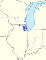
BCIM Map[edit]
Article(s): BCIM
Request: Please create a map (preferably one of the globe ones) showing China, Bangladesh, Myanmar and India. Rvd4life (talk) 15:29, 2 May 2012 (UTC)
Graphist opinion(s):
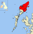
Kingdom of Bora Bora map[edit]
Article(s): Bora Bora, Kingdom of Bora Bora
Request: Please create a map of the kingdom consisting of the islands of Bora Bora, Tupai, Maupiti, Maupihaa, Motu One, and Manuae. Thanks. --KAVEBEAR (talk) 00:32, 28 February 2012 (UTC)
Graphist opinion(s): Request at the Map Workshop
Take a look a this map[1]. Is it OK (one island is missing because it lies far away)? I selected untypical contrast colors because some island are very small. --Jkan997 (talk) 21:36, 24 April 2012 (UTC)
Battle of Wareo[edit]
Article(s): Battle of Scarlet Beach, Battle of Finschhafen, Battle of Sattelberg, Battle of Wareo
Request: If possible, I would like someone to create an area map depicting the area around the Huon Peninsula in New Guinea and including various locations such as Finschhafen, Jivevaneng, Sattelberg, Katika, North Hill, Pabu, Nongora, Christmas Hills, Wareo and Gusika, and including the various large water features, such as the Lakes east of Wareo and the Lagoon north of Gusika, as well as the Song and Kalueng Rivers. There is no need to include military symbols (I just want an area map showing the locations in relation to each other). Some source material is available on Dexter, p. 660 which can be found here in pdf form: [2] and p. 461 here [3]. Thanks in advance. Regards, AustralianRupert (talk) 23:36, 25 May 2012 (UTC)
Graphist opinion:
Map of Society Islands from Manuae to Mehetia, again[edit]
-
 replicate this with all islands from Manuae to Mehetia
 -
 Like this except with more detail
 -
 Map in question
_topographic_map-fr.svg)


Article(s): Society Islands, Windward Islands, Mehetia, Tahiti, Tetiaroa, Moorea, Maiao, Leeward Islands, Huahine, Raiatea, Tahaa, Bora Bora, Tupai, Maupiti, Maupihaa, Motu One (Society Islands), Manuae (Society Islands)
Request: Can someone cut some new maps, 1. especially for the Windward Islands from Maupiti to Mehetia; 2. make another two (one of all the islands and another of just the main islands from Maupiti to Tahiti) without topography for future use as political maps for some of the former kingdoms of the islands.--KAVEBEAR (talk) 01:49, 27 May 2012 (UTC)
Graphist opinion(s):
Resolved[edit]
Spelling error[edit]
-
 elections map

Article(s): United States presidential election, 2004
Request: The two letter abbrev for Alaska is AK not AL (The colors are garish, but I'll leave that for another day) SPhilbrick(Talk) 01:09, 27 May 2012 (UTC)
Graphist opinion(s):
![]() Done Ma®©usBritish[chat] 01:55, 27 May 2012 (UTC)
Done Ma®©usBritish[chat] 01:55, 27 May 2012 (UTC)
- Bonus: Made colours less bright also. Ma®©usBritish[chat] 02:11, 27 May 2012 (UTC)
- Thanks, and the colors look much better now.--SPhilbrick(Talk) 12:26, 27 May 2012 (UTC)
Lewis and Harris[edit]
-
 Lewis
Lewis -
 Harris


Hi. Lewis has a nice map in the infobox showing the extent of this region. Harris, on the other hand, has a dot, which does not help to show the extent of this second region. Lewis and Harris also has no map anywhere to show the boundary between these regions. It would be nice to have more useful maps, with shaded areas, in these second two articles. Perhaps if the map at Lewis was used as a base, this would not be too hard to do for someone with graphics skills. 86.146.108.51 (talk) 20:47, 24 May 2012 (UTC)
Graphist opinion(s):
![]() Done I also coloured the adjacent small islands as was done with the Lewis map. I can change that in the Harris map or in both maps if desired. Cheers! -- Orionist ★ talk 06:29, 25 May 2012 (UTC)
Done I also coloured the adjacent small islands as was done with the Lewis map. I can change that in the Harris map or in both maps if desired. Cheers! -- Orionist ★ talk 06:29, 25 May 2012 (UTC)
- Thanks, that's great! I have added it to the article. If you have the time and inclination, would you be able to do a similar one with both regions shaded in different colours suitable for the article Lewis and Harris? 86.181.172.218 (talk) 17:52, 25 May 2012 (UTC)
Translate Philly SVG (translations given)[edit]
-
 French Map of Philadelphia
 -
 English Map of Philadelphia


Article(s): Transportation in Philadelphia
Request: Could someone please translate this map to English. The translation is pretty easy:
- Vers = Towards
- Comté ligne = County line
- Comté et ville de Philadelphia = City and County of Philadelphia
- Parc = Park
- Aéroport International = International Airport
My inability is to edit and change the SVG. gren グレン 06:27, 30 May 2012 (UTC)
![]() Done
Done
Graphist opinion(s):


Article(s): Current members of the United States House of Representatives
Request: Really really easy request ... the Eastern shore of Virginia is blue and should be the same color as the rest of Virginia. Really, even better would be to have an SVG version of this map like File:111th US Congress House of Reps.svg - the old version looks so much better. Thanks. --B (talk) 04:48, 19 June 2012 (UTC)
Graphist opinion(s):![]() Done Makeemlighter (talk) 20:24, 28 June 2012 (UTC)
Done Makeemlighter (talk) 20:24, 28 June 2012 (UTC)
Massachusetts Governor's Council district map[edit]
-
 2007 Massachusetts Governor's Council district map
 -
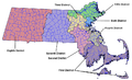 2012 Massachusetts Governor's Council district map


Article(s): Massachusetts Governor's Council
Request: A new map is needed because of redistricting. The following resources are available:
- Secretary of State listing of towns and precincts in each district
- MA legislature page showing district maps (direct link to council district map)
- MASS GIS layers containing district shapes
The new image should probably be uploaded with a dated name (e.g. Massachusetts Councillor Districts 2012.<ending>). Magic♪piano 15:58, 2 May 2012 (UTC)
Graphist opinion(s):
![]() Request taken by Presidentman talk · contribs Random Picture of the Day (Talkback).
Request taken by Presidentman talk · contribs Random Picture of the Day (Talkback).
![]() Done- Presidentman talk · contribs Random Picture of the Day (Talkback) 11:38, 3 July 2012 (UTC)
Done- Presidentman talk · contribs Random Picture of the Day (Talkback) 11:38, 3 July 2012 (UTC)
Kananaskis bragg at en.wikibooks[edit]
Article(s): b:en:Hiking in the Canadian Rockies/Day Hikes/Kananaskis/Bragg Creek and Elbow River
Request: Something strange request and yes, I know this is for the sister project wikibooks: This image is using an invalid fair use claim and before it gets deleted (already nominated, will likely be halted until somebody created this image), I want somebody to create a free SVG equivalent of that. mabdul 22:50, 28 May 2012 (UTC)
- I'm expanding this request with the many more founded images based on the original. mabdul 23:14, 28 May 2012 (UTC)
- I found the original map here in a great quality, but moreover I also found File:Kananaskis park system.png at Commons, so I only need somebody doing a color job and painting some color borders in similar to the other maps listed above. mabdul 15:59, 13 June 2012 (UTC)
Graphist opinion(s):
Curve-billed Thrasher[edit]

Article(s): Curve-billed Thrasher
Requests: The link of the map I would like to use comes from this site: [4]. I don't want the state/country names, but I do want the borders (states and countries) to remain intact for the image. I plan on expanding the article of the bird, and hope to use this map. Thanks for reading! LeftAire (talk) 22:07, 29 June 2012 (UTC)
Graphist(s) opinions:
![]() Request taken by Presidentman.
Request taken by Presidentman.
![]() Done - Presidentman talk · contribs Random Picture of the Day (Talkback) 00:35, 4 July 2012 (UTC)
Done - Presidentman talk · contribs Random Picture of the Day (Talkback) 00:35, 4 July 2012 (UTC)
PASL-Pro[edit]
-
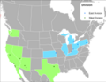 Map of all the teams in the PASL-Pro

Article(s): Professional Arena Soccer League
Request: Add Harrisburg(Eastern divison) and Dallas (Western divison) to the map. Also remove the CMISL from the map or make a separate map for them for their article. Spongie555 (talk) 05:31, 14 May 2012 (UTC)
Graphist opinion(s):
![]() Request taken by Presidentman.
Request taken by Presidentman.
![]() Done - Presidentman talk · contribs Random Picture of the Day (Talkback) 19:15, 5 July 2012 (UTC)
Done - Presidentman talk · contribs Random Picture of the Day (Talkback) 19:15, 5 July 2012 (UTC)
Texas Hill Country Map[edit]

Article(s): Texas Hill Country
Request: can this be fixed so it doesn't just look like it was sprayed down in Microsoft Paint?... Kintetsubuffalo (talk) 13:46, 12 June 2012 (UTC)
Graphist opinion(s):
![]() Request taken by Presidentman.
Request taken by Presidentman.![]() Done - Presidentman talk · contribs Random Picture of the Day (Talkback) 19:25, 5 July 2012 (UTC)
Done - Presidentman talk · contribs Random Picture of the Day (Talkback) 19:25, 5 July 2012 (UTC)
- Thank you!--Kintetsubuffalo (talk) 19:39, 5 July 2012 (UTC)
American Catholic dioceses[edit]

Article(s): File:US Roman Catholic dioceses map.png#File usage
Request: This map gets captioned with "The color for Omaha (Nebraska) is slightly different from that of Denver (Colorado and Wyoming)." Ok, if I squint and look at my monitor from an odd angle, I can see that. But this is misleading, even with the explanation in the caption (pictures being worth a thousand words and all). This really shouldn't be a difficult fix, though. Switch either the Omaha or Denver diocese colors with Anchorage's, Boston's, or any other one where we won't have adjacent similar colors. I don't want to sound too critical here—this is otherwise a very helpful map. But how hard could this be to fix? --BDD (talk) 16:52, 15 June 2012 (UTC)
Graphist opinion(s):
![]() Request taken by Presidentman.
Request taken by Presidentman.![]() Done - Presidentman talk · contribs Random Picture of the Day (Talkback) 19:37, 5 July 2012 (UTC)
Done - Presidentman talk · contribs Random Picture of the Day (Talkback) 19:37, 5 July 2012 (UTC)
International cricket council membership upgrade[edit]
-
 Members of icc

Article(s): International Cricket Council
Request:Please add Russia and Hungary to the map as these countries have been acceepted as affiliate members(purple) of the icc.Also the membership of Swtizerland has been terminatedSpecial:Contributions/Ancientphoenixians (talk) 04:30, 4 July 2012 (UTC)
Graphist opinion(s):
![]() Request taken by Presidentman.
Request taken by Presidentman.
![]() Done - Presidentman talk · contribs Random Picture of the Day (Talkback) 14:10, 4 July 2012 (UTC)
Done - Presidentman talk · contribs Random Picture of the Day (Talkback) 14:10, 4 July 2012 (UTC)
Flemish Diamond map[edit]
-
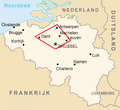 Flemish Diamond map

Article(s): Flemish Diamond
Request: Please translate into English. - Presidentman talk · contribs Random Picture of the Day (Talkback) 20:30, 11 July 2012 (UTC)
Graphist opinion(s):
![]() Done: Will this work? Yeah, just realized I named it wrong. Will request name change. file:Flemish Triangle map.svg or file:Flemish Diamond map.svg 25or6to4 (talk) 01:43, 15 July 2012 (UTC)
Done: Will this work? Yeah, just realized I named it wrong. Will request name change. file:Flemish Triangle map.svg or file:Flemish Diamond map.svg 25or6to4 (talk) 01:43, 15 July 2012 (UTC)
- Yes! Thank you! - Presidentman talk · contribs Random Picture of the Day (Talkback) 17:02, 15 July 2012 (UTC)
Tri-Cities, Washington[edit]
![]() Done - file:Tri-Cities map.svg 25or6to4 (talk) 21:58, 15 July 2012 (UTC)
Done - file:Tri-Cities map.svg 25or6to4 (talk) 21:58, 15 July 2012 (UTC)
- Thank you. – Allen4names (IPv6 contributions) 00:13, 16 July 2012 (UTC)
European Union Heads of State and Government[edit]
Article(s): European Council
Request: Create a map of the European Union about the Europarty affiliation of Head of State and Government of the EU member states. Maybe put the Party of European Socialists in red, the European People's Party in pale blue, the Alliance of European Conservatives in dark blue and grey out countries not in the EU.--Jay942942 (talk) 14:47, 22 May 2012 (UTC)
Graphist opinion(s):
- Comment This is already created: File:Party affiliations in the European Council (20 June 2012).svg. - Presidentman talk · contribs Random Picture of the Day (Talkback) 20:47, 5 July 2012 (UTC)
BMO Harris Bank[edit]
-
 Harris Bank footprint
 -
 Marshall & Ilsley footprint


Article(s): BMO Harris Bank
Request:the two maps need to be combined to show the new BMO Harris Banks footprint after harris and Marshall & Ilsley bank merged
Graphist opinion(s):
- Comment Has already been created: File:BMO Harris Bank 2012-06.png. - Presidentman talk · contribs Random Picture of the Day (Talkback) 21:01, 5 July 2012 (UTC)
Distribution map needed for Chimney Swift update[edit]

Article(s): Update/revision of Chimney Swift being developed in my sandbox
Request: Need a distribution map for the Chimney Swift (Chaetura pelagica) article update. The distribution map should follow guidelines of Wikiproject:Birds for distribution maps. The sample in the Project page is misleading. Because the Chimney Swift is native only to the western hemisphere, the map should be of the bird's native range, not the entire world. Example of a distribution map in a featured article at Common House Martin. DocTree (talk) 06:04, 8 July 2012 (UTC)
Sources: USGS Breeding Bird Survey (Fairly recent and reliable for N. America)
Birdlife (Uses colors preferred by Wikiproject:BIRDS)
AllAboutBirds] (Click the "View dynamic map of eBird sightings" below the distribution map as a shortcut to
eBird. Click Explore Data, then Range and Point Maps and enter either Chimney Swift or Chaetura pelagica, then change the dates to a recent range, current year or 2010-2012. eBird is the most up-to-date data available.
Comments Almost all (maybe all) distribution maps for Chimney Swifts (CHSW) in dead tree references are out-of-date. Multiple sources show that the total number of CHSW has been dropping for decades. The CHSW conservation status was recently changed from 'Least Concern' to 'Near Threatened'. At the same time, the breeding range spread to the west while retracting south. Only a few breeding pairs have been documented in Ontario, Canada, and only in the far south along the border with the USA. A few decades ago, CHSW were common through much of Ontario but rare in Colorado where they have become common.
Ignore the occasional observations of CHSW in California reported and confirmed by eBird. The reports are accurate but those are considered vagrants or itinerants. A pair of vagrants are occasionally sighted and confirmed far outside the normal range as far away as Scotland, Greenland and Ireland. Until there are more sightings or confirmed nesting, California should not be shown as part of the CHSW distribution. Areas where there are many reports, such as Colorado Springs, Bolder and Fort Collins, Colorado, should be included.
The non-breeding range is still not exact. It was considered 'a mystery' until the late 20th century when a native tribesman came out of the Amazon jungles with a collection of bird bands that he thought might be valuable. The uncertainty of the non-breeding distribution will be explained in text (including the story of the band recovery unless the consensus is "too much detail").
Graphist opinion(s):
![]() Request taken by Presidentman.
Request taken by Presidentman.
![]() Done Here is the map. Presidentman talk · contribs Random Picture of the Day (Talkback) 13:38, 10 July 2012 (UTC)
Done Here is the map. Presidentman talk · contribs Random Picture of the Day (Talkback) 13:38, 10 July 2012 (UTC)
UK EEZ[edit]
-

-
 Better PNG version


Article(s): Exclusive_Economic_Zone#United_Kingdom
Request: Add in EEZ for Cayman Islands on SVG version which seems to be missed out.92.14.183.23 (talk) 21:41, 8 June 2012 (UTC)
Graphist opinion(s): Done. Kmusser (talk) 15:34, 26 July 2012 (UTC)
Reformation.gif[edit]
-
 Description of image

.svg)
Article(s): Protestant Reformation
Request: Can you please make the blue areas appear? Currently, this map shows only the grey and olive areas. Fconaway (talk) 23:31, 14 July 2012 (UTC)
Graphist opinion(s):
![]() Comment: Not a graphicist, but when I look at Protestant Reformation, I see the blue areas just fine. --Philosopher Let us reason together. 03:40, 18 July 2012 (UTC)
Comment: Not a graphicist, but when I look at Protestant Reformation, I see the blue areas just fine. --Philosopher Let us reason together. 03:40, 18 July 2012 (UTC)
Looks fine to me too. Marking resolved. Kmusser (talk) 16:18, 26 July 2012 (UTC)