
Wikipedia:Graphics Lab/Map workshop/Archive/Jul 2011
Stale[edit]
Map of towns represented by delegates during All-Albanian Congress which resulted with Albanian Declaration of Independence[edit]
-
 Map of four Albanian vilayets (Kosovo Vilayet, Monastir Vilayet, Ioannina Vilayet and Shkodër Vilayet) without border between them
 -
 Map of Kosovo Vilayet, with borders of other Albanian Vilayets
 -
 Map of Ottoman Empire at the beginning of 20th century with clearly defined "Albanian" vilayets

_map.png)
.svg)
Article(s): Albanian Declaration of Independence
Request: I would like to have a map with clearly defined borders of four Albanian vilayets and all signatories of the Albanian Declaration of Independence presented with points (towns) on the map, depending on the city they represented during All-Albanian Congress. When reader point to the specific town I would like that he would be presented with a small text (within some kind of pop out infobox if possible) with names of all signatories of the Albanian Declaration of Independence from that city, and the name of the villayet. A map of the four albanian vilayets can be used for the basis of new map together with the data about signatories of the Albanian Declaration of Independence. There are signatories from Romania, that should be listed within separate legend, if possible. In case that any additional information is needed, please do not hasitate to contact me on my talk page. Thanks in advance. Antidiskriminator (talk) 10:35, 1 May 2011 (UTC)
- I am willing to do my best to assist someone who would be willing to make such map.--Antidiskriminator (talk) 22:07, 2 June 2011 (UTC)
Graphist opinion(s):
Redraw File:Operation Kita.jpg[edit]
-
 Map to be redrawn
 -
 Possible base map 1
 -
 Possible base map 2
 -
 Possible base map 3
 -
Route drawn

.svg)
.svg)
.svg)
Article(s): operation Kita
Request: Vectorize and clean up. I've given three SVG maps that can be used as a base, with the proper projection; simply uncolor and add in the convoy's route. This is for the A-class review of the article; if you need to use map symbols, use the MILHIST templates. bahamut0013wordsdeeds 11:56, 20 May 2011 (UTC)
Graphist opinion(s):
![]() Request taken by Derfel73.
Request taken by Derfel73.
Will the map need colouring in red and black to show the territory held by the Allies and Japan? — Preceding unsigned comment added by Derfel73 (talk • contribs) 13:49, 8 June 2011 (UTC)
Queen Maud Land[edit]
Article(s): Queen Maud Land
Request: The article has a basic map showing the outline of the territory, but the article could use a more in-depth map (I plan to start improving the article for GA). I have found a map I like which is more or less how I imagine it at the Norwegian encyclopedia Store norske leksikon [1]. If someone could make a map similar to this it would be much appreciated. The text in the cited map is in Norwegian, but I should be able to translate it for a new map if needed. – Bellatores (t.) 18:44, 9 May 2011 (UTC)
Graphist opinion(s):
High Line[edit]

Article(s): High Line (New York City)
Request: Please expand map, which is missing the lower portion where the line used to run. You can base your work here or also rotate the edited map slightly to make the streets on a horizontal level [2]. Gryffindor (talk) 00:24, 11 June 2011 (UTC)
Graphist opinion(s): The map is correct per the article. - Presidentman talk·contribs Random Picture of the Day (Talkback) 11:36, 11 June 2011 (UTC)
- No I'm afraid you must have misunderstood. I am referring to the lower second map on the webpage (Neighborhood Context Map), which shows the how the original line (labelled "Original High Line (demolished)") actually continued onwards south of Gansevoort Street along Washington Street until it reached St. John's Terminal, it's also described in the article. My request is to extend the map. Gryffindor (talk) 13:44, 11 June 2011 (UTC)
Quick Map of Verendrye journey ?[edit]
-
![Double Click to see. Fort La Reine is north of the last 'a' in 'North Dakota'. The Mandan village was probably at the 'S' of Lake Sacakawea'. The Big Horn Mountains are between the Bighorn and Powder Rivers. The Black Hills are at Rapid City. Pierre is south of the 'H' in Huron]]](//upload.wikimedia.org/wikipedia/commons/thumb/f/ff/Missouri_River_basin_map.png/120px-Missouri_River_basin_map.png) Double Click to see. Fort La Reine is north of the last 'a' in 'North Dakota'. The Mandan village was probably at the 'S' of Lake Sacakawea'. The Big Horn Mountains are between the Bighorn and Powder Rivers. The Black Hills are at Rapid City. Pierre is south of the 'H' in Huron]]
Double Click to see. Fort La Reine is north of the last 'a' in 'North Dakota'. The Mandan village was probably at the 'S' of Lake Sacakawea'. The Big Horn Mountains are between the Bighorn and Powder Rivers. The Black Hills are at Rapid City. Pierre is south of the 'H' in Huron]]
![Double Click to see. Fort La Reine is north of the last 'a' in 'North Dakota'. The Mandan village was probably at the 'S' of Lake Sacakawea'. The Big Horn Mountains are between the Bighorn and Powder Rivers. The Black Hills are at Rapid City. Pierre is south of the 'H' in Huron]]](/wiki/File:Missouri_River_basin_map.png)
Article(s):Louis-Joseph Gaultier de La Vérendrye
Request: This should be fairly easy if someone wants to. All that is needed is to draw a line on an existing map, add some labels and possibly crop the original map to a smaller area. Everything needed is in the article. It should be called VerendryePossibleRoute or similar since the route is not certain. 'Mandan Village?' should end in a question mark. Benjamin Trovato (talk) 02:14, 19 May 2011 (UTC)
Graphist opinion:
Redraw as SVG the Pernambuco map[edit]
-
 PNG map.
 -
 SVG map of other Brazilian state, such example.


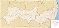
Article(s): Pernambuco
Request: Convert the PNG map to SVG map. Luan (discussão) 05:42, 19 June 2011 (UTC)
Graphist opinion(s):
Map of Districts in Shanghai[edit]
-
 ie: the map that needs correcting (you may need to see it on the actual page

Article(s): List_of_administrative_divisions_of_Shanghai
Request: The map and the clickable links that identify the map and districts are out of alignment. 58.38.211.135 (talk) 01:24, 20 June 2011 (UTC)
Graphist opinion:
Blake River Megacaldera Complex[edit]
Article(s): Blake River Megacaldera Complex
Request: The article has a basic map showing the outline of the volcano, but the article could use a more in-depth map (I plan to start improving the article for GA or even FA). On this webpage there is a geologic map on page 3 that would be good to show the overall geology of the volcano (don't include the "showings" as they are unnesessary). The article could also use a better location map as the current map is a bit messy. Volcanoguy 07:09, 26 May 2011 (UTC)
Graphist opinion(s):
Resolved[edit]
Mongols in China[edit]
-
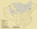 Mongolia + areas inhabited by Mongols in China
 -
 Modified as per the request: Mongolia has been removed


Article(s): Mongols in China
Request: Remove Mongolia from the map and upload the new picture to File:Mongol Autonomous Subjects in the PRC.png. Quigley (talk) 00:55, 1 July 2011 (UTC)
Graphist opinion(s):
![]() Done Derfel73 (talk) 12:38, 1 July 2011 (UTC)
Done Derfel73 (talk) 12:38, 1 July 2011 (UTC)
Convert png to svg[edit]
-
 Description of image

Article(s): Turkish general election, 2011
Request: Convert file to svg. Make background invisible. I tried it myself, but with little success: File:2011 Turkish general election.svg. Please upload it under the same name on Commons. --Randam (talk) 11:14, 16 June 2011 (UTC)
Graphist opinion(s):
![]() Done --Randam (talk) 23:03, 30 June 2011 (UTC)
Done --Randam (talk) 23:03, 30 June 2011 (UTC)
Pruth campaign of 1711[edit]

Article(s): Military history of the Russian Empire, Pruth River Campaign
Request: Easy peasy, it's just that the country names are in Spanish: "Polonge" should be "Poland", "Moldavie" should be "Moldavia", et. cetera. Thanks. ResMar 00:37, 19 June 2011 (UTC)
Graphist opinion(s):
![]() Done Translated requested places (from French) as well as a few others. Derfel73 (talk) 14:44, 19 June 2011 (UTC)
Done Translated requested places (from French) as well as a few others. Derfel73 (talk) 14:44, 19 June 2011 (UTC)
A map of archaic globalization (simple)[edit]
-
-

-
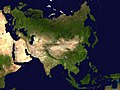
 New vector image as per the request

.svg)

Article(s): Archaic globalization, History of globalization, Pax Mongolica, World-system theory
Request: This should be a very simple request: based on File:Archai.jpg (non-free), just add some circles and oblongs and its ready. If you fill ambitious, you can use different colors and add a built-in legend, but it is not necessary. If the image is deleted, I've a local copy. Piotr Konieczny aka Prokonsul Piotrus| talk 19:45, 2 July 2011 (UTC)
Description:
A map of the 13th century world system. Euroasia divided into regions: I: North-west Europe (Champagne Fairs), II-South Europe (Italian city states of Venice and Genoa), III-Mongol Empire, IV-Middle East (Persia), V-Egypt, VI-Western India, VII-Eastern India, VIII-China.
This image could be replaced
Author: Janet L. Abu-Lughod
Date: 1991
Source: Janet L. Abu-Lughod (1 February 1991). Before European hegemony: the world system A.D. 1250-1350. Oxford University Press US. ISBN 9780195067743. Retrieved 14 June 2011.
Graphist opinion:
![]() Done Derfel73 (talk) 21:07, 2 July 2011 (UTC)
Done Derfel73 (talk) 21:07, 2 July 2011 (UTC)
metallurgy[edit]


Article(s): metallurgy
Request: Auf Englisch, bitte ;) ... Kintetsubuffalo (talk) 13:40, 9 July 2011 (UTC)
Graphist opinion(s):
![]() Done Translated into English Derfel73 (talk) 19:47, 9 July 2011 (UTC)
Done Translated into English Derfel73 (talk) 19:47, 9 July 2011 (UTC)
- Thank you so much! I really appreciate the good work!--Kintetsubuffalo (talk) 03:58, 10 July 2011 (UTC)
Foreign Relations of Bhutan[edit]
-
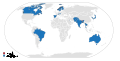 Diplomatic relations of Bhutan

Article(s): Foreign relations of Bhutan
Request: Color in Spain as they set up relations also while we are fixing the map maybe add the border of south and north sudan to update the world map. Spongie555 (talk) 05:40, 9 July 2011 (UTC)
Graphist opinion(s):
![]() Done Derfel73 (talk) 10:57, 9 July 2011 (UTC)
Done Derfel73 (talk) 10:57, 9 July 2011 (UTC)
- Sorry to bother but I don't see any changes to it. Spongie555 (talk) 21:22, 9 July 2011 (UTC)
- Nor do I, though if one looks at the file itself, the changes are visible: http://upload.wikimedia.org/wikipedia/commons/6/68/Bhutan_Relations_2010.svg. According to Wikimedia commons, there are problems with thumbnail generation to which a solution is being worked on. Derfel73 (talk) 11:37, 12 July 2011 (UTC)
Map for Woomera Test Range[edit]
-
 Map of South Australia
 -
 Map of Australia


Article(s): Woomera Test Range
Request: Could someone create a map showing the area covered by the Woomera test range? There are two PDF maps linked here that show the extent of the current area in relation to the state of South Australia or the continent as a whole, and a news article here that (down the bottom), shows the current and previous extent of the site. The 'current' area should be sufficient for the article's needs. I leave it for the discretion of the mapmaker as to whether you do it based on the South Australia or Australia maps. Thanks in advance! -- saberwyn 01:43, 13 July 2011 (UTC)
Graphist opinion(s):
![]() Request taken by Pi.1415926535.: Can do. Pi.1415926535 (talk) 01:49, 13 July 2011 (UTC)
Request taken by Pi.1415926535.: Can do. Pi.1415926535 (talk) 01:49, 13 July 2011 (UTC)
![]() Done: It's not perfect - I had a hard time getting a sharp enough base image for the range - but it's decent. Pi.1415926535 (talk) 02:44, 13 July 2011 (UTC)
Done: It's not perfect - I had a hard time getting a sharp enough base image for the range - but it's decent. Pi.1415926535 (talk) 02:44, 13 July 2011 (UTC)

- That'll do nicely. Much appreciated! -- saberwyn 03:10, 13 July 2011 (UTC)
South Sudan–Sudan relations[edit]
-
 Multiple regions of Sudan

Article(s): South Sudan–Sudan relations
Request: Need a map for these 2 states, it should be pretty easy as some variations alreayd exist. everything other than the blue needs to be the same colour. Thx. Lihaas (talk) 17:17, 10 July 2011 (UTC)
Graphist opinion(s):
Israel – South Sudan relations[edit]
Article(s): Israel – South Sudan relations
Request: Need a map showing the 2 states per relations pages maps. [[3]] could be the outline basis for SOuth Sudan. Thx Lihaas (talk) 19:16, 11 July 2011 (UTC)
Graphist opinion(s):
Map of Vieques[edit]
Article(s): Vieques
Request: Hi, currently this map is available in two sizes: a small "preview" size displayed at File:Vieques Barrios.jpg and a humungously large size that tries to open when you click on the former but grinds my PC to a complete halt. I wonder if it would be possible to provide a more sensibly sized midway version where all the text is legible but the image can be loaded into the average browser within the average user's timespan of tolerance. 81.159.106.31 (talk) 02:47, 18 July 2011 (UTC)
Graphist opinion:![]() Done Vieques Barrios cropped.jpg All the text is legible. 6907 * 2482 px. 4.96 MB. Easy to load for the browsers. Upload it anywhere you want. – ∃ Aditya 7 ¦ 16:58, 19 July 2011 (UTC)
Done Vieques Barrios cropped.jpg All the text is legible. 6907 * 2482 px. 4.96 MB. Easy to load for the browsers. Upload it anywhere you want. – ∃ Aditya 7 ¦ 16:58, 19 July 2011 (UTC)
Australia/New Guinea Map[edit]
-
 Like this...
 -
 ...but in this style


Article(s): Papilio aegeus
Request: I've been creating some range maps lately, and I was interested in creating a range map showing a range that is across both Australia and Papua New Guinea. To do this I'm going to need a range map that shows both countries, but I'm having trouble finding one. I did find this one, but I'd prefer if there wasn't that slanty-curve on it. I'm looking for a map that is grey, blank without labels, such as this (but showing New Guinea also).
Does anybody know where a map like this is? Or is there some place where I can crop it from? --JamesDouch (talk) 11:12, 21 July 2011 (UTC)
Graphist opinion(s): Maybe this one: File:Blank Map Oceania.svg? -MissMJ (talk) 19:50, 21 July 2011 (UTC)