
Wikipedia:Graphics Lab/Map workshop/Archive/Apr 2019
| This page is an archive. Do not edit the contents of this page. Please direct any additional comments to the current main page. |

Request for a Palm Beach County, Florida map
-
 Example Florida county map

- Article(s)
- All Palm Beach County High School pages. Example: Suncoast Community High School
- Request
- I am requesting a geographical map of Palm Beach County, FL so I can use them in the infoboxes for Palm Beach County High Schools. I got inspired from seeing this article: Union City High School. -- — BladeRikWr 18:36, 17 April 2019 (UTC)
- Discussion
Have you tried using {{OSM Location map}}? It can automatically produce a map, like the one below: --RaviC (talk) 13:21, 30 April 2019 (UTC)

- That sounds like a plan! If I have any other questions, I'll leave them on your talk page. {{resolved}}
Greater Beirut svg map
Hi, would anyone be kind enough to create a map of Greater Beirut in the same style of this map on Beirut? I'm asking here because I'm not able to do so myself. The coordinates on OSM should be N: 33.9838, S: 33.7860, E: 35.6802, W: 35.4220. Thanks for your help, Nehme1499 (talk) 11:21, 21 April 2019 (UTC)
- Have you tried using {{OSM Location map}}? It can automatically produce a map, like the one below:
--RaviC (talk) 13:27, 30 April 2019 (UTC)

Modifying Infobox Map to suit geographical coordinates


- Request
The maps in use in the infoboxes of the Kolkata neighbourhoods, say for example Sealdah or Ballygunge pages (the first map above), is rather unclear and does not show much. There is a map in the Infobox of Dharmatala page (the second map above) which is much clearer and shows some important neighbourhoods. However, this map is not adjusted to geographical coordinates as those in the Sealdah or Ballygunge pages. Kindly make the map on the Dharmatala page suitable to take in geographical coordinates. Then it can be used on different pages of Kolkata neighbourhoods as an alternateive to the present map. The present map need not be removed. It can also continue without any change and editors can choose between the two. Kindly help. In Wikimedia Commons Commons:Category:Maps of Kolkata, there are similar but undisturbed maps. Cheers. - Chandan Guha (talk) 23:06, 18 March 2019 (UTC)
- Chandan Guha, Have you contacted the original author? Here is an alternative using {{OSM Location map}}, that may be of help.

Arjunaraoc (talk) 00:02, 18 April 2019 (UTC)
- Arjunaraoc I had contacted Jayantanth, the original author, regarding this map a long time before I had put in this request. If you see the use of this map on the Dharmatala page you will find it is suited for that particular page only. That means, in his system there has to be a separate map for each page. He had agreed to help me with around 140 maps for use on Ward No. 46, Kolkata Municipal Corporation and similar pages. However, I find him to be a very busy person and he is not getting any time to develop so many maps.
- I still feel that if some one could convert the map to be adjusted against geographical coordinates, it would be of great help for Kolkata-related pages.
- Many thanks for the OSM Location Map suggestion. It would go in very well in the neighbourhood pages related to Kolkata. I have placed it in the Sealdah page. However, there is one problem with OSM Location Maps. The small map is not coming on in mobile phones unless it is placed at the top of the page. The full screen map is coming on in mobile phones also. I have been using a different version of the OSM Location Map quite extensively. See Naihati page. I have already approached RobinLeicester, who taught me the fundamentals of this map, for help.
- Cheers - Chandan Guha (talk) 01:41, 18 April 2019 (UTC)
- @Chandan Guha, Thanks for your update. Did you try Kartographer, which does not have mobile display issues as per my knowledge.Arjunaraoc (talk) 05:09, 18 April 2019 (UTC)
- @Arjunaraoc Thanks for Kartographer information. I had not come across it. I am hopeful about the OSM problem being solved. People are working on it. Cheers. Chandan Guha (talk) 05:18, 18 April 2019 (UTC)
- @Chandan Guha the template version of kartographer at {{maplink}} also now has a framed option. It has all the open street map zoom and location adjustments but cannot add text, so would just show one or more pointer markers (plus boundary lines and other options, where the open street map values have been defined) but might give you a good equivalent to {{OSM Location map}} for your purposes. RobinLeicester (talk) 21:06, 23 April 2019 (UTC)
- @RobinLeicester, @Jayantanth I am not really looking for an alternative to the OSM Location maps. I am quite happy about these. I am using these quite extensively. However, the OSM Location maps don’t fit into the Infoboxes. The problem is only with the Infobox maps for Kolkata city pages. There are over 200 such pages. Infobox maps for places/ areas outside the city are fine and okay. I have given here an alternative Kolkata city map, that has more details and shall be happy if some one could adjust the map to take in geographical coordinates. It may be noted that User:Jayantanth developed this map for the Dharmatala page
- @Chandan Guha the template version of kartographer at {{maplink}} also now has a framed option. It has all the open street map zoom and location adjustments but cannot add text, so would just show one or more pointer markers (plus boundary lines and other options, where the open street map values have been defined) but might give you a good equivalent to {{OSM Location map}} for your purposes. RobinLeicester (talk) 21:06, 23 April 2019 (UTC)
- @Arjunaraoc Thanks for Kartographer information. I had not come across it. I am hopeful about the OSM problem being solved. People are working on it. Cheers. Chandan Guha (talk) 05:18, 18 April 2019 (UTC)
- @Chandan Guha, Thanks for your update. Did you try Kartographer, which does not have mobile display issues as per my knowledge.Arjunaraoc (talk) 05:09, 18 April 2019 (UTC)
- Cheers - Chandan Guha (talk) 01:41, 18 April 2019 (UTC)
- In the extreme event of the above proposal not being feasible, can the OSM Location map in Ward No. 1, Kolkata Municipal Corporation be fitted in the Infobox? Cheers. - Chandan Guha (talk) 01:22, 24 April 2019 (UTC)
- @Chandan Guha, I created a sample map with coordinates

. Let me know whether it works for you.Arjunaraoc (talk) 05:41, 24 April 2019 (UTC)
- @Arjunaraoc I have placed the map in the Ward No. 1, Kolkata Municipal Corporation page. The OSM map is coming out fine but the coordinates of Ward No. 1 are not working. It would be great, if you can show the Ward as in the map on the left hand side of the page. If it is not possible or too cumbersome, I will manage with this. Thanks a lot. Cheers. - Chandan Guha (talk) 06:13, 24 April 2019 (UTC)
- @Chandan Guha, This needs a page to link to the image and its coordinates. I have named the map reference as "Kolkata Street Map" and the details are stored in Module:Location map/data/Kolkata Street Map and now the pin is shown on the page(permanent link. A ward of caution is the wards are area and it may not be proper to reference them as points. If the wards are present in open street map, them mapframe based map may be easiest to show its boundaries.Arjunaraoc (talk) 08:08, 24 April 2019 (UTC)::
- @Arjunaraoc Fine, many thanks. There are already are many area maps shown with dots, say for example Mongalkote (community development block). Moreover, the wards cover a small area. Cheers. - Chandan Guha (talk) 08:25, 24 April 2019 (UTC)
- @Arjunaraoc Sorry to disturb you. The map needs to be extended length-wise towards the bottom. The location dots are going well outside the map in Ward No. 109, Kolkata Municipal Corporation and Ward No. 142, Kolkata Municipal Corporation.Please keep a little space beyond these points. There is some space at the top. You can adjust it suitably. Cheers. - Chandan Guha (talk) 08:53, 24 April 2019 (UTC)
- @Arjunaraoc I can see that you have started adjusting the map. Please keep a watch on Ward No. 141, Kolkata Municipal Corporation, which is the western-most point. - Chandan Guha (talk) 09:39, 24 April 2019 (UTC)
- @Chandan Guha, Thanks for your alerts. I hope I got it correct now. Please check and let me know.Arjunaraoc (talk) 09:54, 24 April 2019 (UTC)
- @Arjunaraoc I can see that you have started adjusting the map. Please keep a watch on Ward No. 141, Kolkata Municipal Corporation, which is the western-most point. - Chandan Guha (talk) 09:39, 24 April 2019 (UTC)
- @Arjunaraoc Sorry to disturb you. The map needs to be extended length-wise towards the bottom. The location dots are going well outside the map in Ward No. 109, Kolkata Municipal Corporation and Ward No. 142, Kolkata Municipal Corporation.Please keep a little space beyond these points. There is some space at the top. You can adjust it suitably. Cheers. - Chandan Guha (talk) 08:53, 24 April 2019 (UTC)
- @Arjunaraoc Fine, many thanks. There are already are many area maps shown with dots, say for example Mongalkote (community development block). Moreover, the wards cover a small area. Cheers. - Chandan Guha (talk) 08:25, 24 April 2019 (UTC)
- @Chandan Guha, This needs a page to link to the image and its coordinates. I have named the map reference as "Kolkata Street Map" and the details are stored in Module:Location map/data/Kolkata Street Map and now the pin is shown on the page(permanent link. A ward of caution is the wards are area and it may not be proper to reference them as points. If the wards are present in open street map, them mapframe based map may be easiest to show its boundaries.Arjunaraoc (talk) 08:08, 24 April 2019 (UTC)::
- @Arjunaraoc I have placed the map in the Ward No. 1, Kolkata Municipal Corporation page. The OSM map is coming out fine but the coordinates of Ward No. 1 are not working. It would be great, if you can show the Ward as in the map on the left hand side of the page. If it is not possible or too cumbersome, I will manage with this. Thanks a lot. Cheers. - Chandan Guha (talk) 06:13, 24 April 2019 (UTC)
@Arjunaraoc Great job done. It seems to be okay now. Many thanks. Cheers. - Chandan Guha (talk) 09:59, 24 April 2019 (UTC)
![]() Done Arjunaraoc (talk) 04:23, 25 April 2019 (UTC)
Done Arjunaraoc (talk) 04:23, 25 April 2019 (UTC)
- @RobinLeicester,@Arjunaraoc, @Jayantanth - 144 pages from Ward No. 1, Kolkata Municipal Corporation to Ward No. 144, Kolkata Municipal Corporation have the OSM Location map and this infobox map.Thanks and cheers. - Chandan Guha (talk) 11:02, 30 April 2019 (UTC)
Nader Shah, Afsharid map
.svg)

- Article(s)
- Persian Empire (amongst others)
- Request
- Please adjust the borders depicted in the first map (i.e., File:Afsharid_dynasty_(greatest_extent) to match those depicted in the second map (i.e. File:Map_of_the_Afsharid_Empire). As the latter (i.e. second) map is based on proper sources, the first map needs to be adjusted as well, for consistency's sake. Thank you in advance, - LouisAragon (talk) 14:33, 6 April 2019 (UTC)
- Discussion
Commonwealth Games Map
{{resolved}}

- Article(s)
- Commonwealth Games
- Request
- Alright, with the conclusion of the 2018 Commonwealth Games last year, the above map could do with a few changes:
1) Gambia rejoined the CoN in March 2018 and participated in last year's Games, hence it should be changed back to red.
2) The city of Birmingham, England, is set to host the next Games in 2022, and thus should be marked as such.
3) Given that the city of Durban, South Africa, is no longer scheduled to host the 2022 Games, the marker for the city should be removed from the map, and South Africa itself changed from purple back to red, as it no longer qualifies as a country that has hosted or plans to host the Games (after all, Montreal and Cardiff were scheduled to host the cancelled 1942 and 1946 Games respectively, and yet neither are marked as such, hence Durban shouldn't be either).
Thanks. Snow Lion Fenian (talk) 16:18, 28 April 2019 (UTC)
- Discussion
![]() Done --RaviC (talk) 13:17, 30 April 2019 (UTC)
Done --RaviC (talk) 13:17, 30 April 2019 (UTC)
- @RaviC: Very nice work, and thanks for doing this. Just one thing though, would it be possible to have the dot marking Durban and the crossed out 2022 beside it removed from the map completely? It's just that there's no crossed out markers for 1942 and 1946 over the cities of Montreal and Cardiff, hence there probably shouldn't be one for the cancelled Durban 2022 Games either. Sorry about this. Snow Lion Fenian (talk) 19:39, 6 May 2019 (UTC)
- No worries, I've just done that. --RaviC (talk) 21:15, 6 May 2019 (UTC)
- @RaviC: That's fine, and much appreciated, thanks. Snow Lion Fenian (talk) 17:45, 7 May 2019 (UTC)
- No worries, I've just done that. --RaviC (talk) 21:15, 6 May 2019 (UTC)
Wikification request
- Article(s)
- Death of Blair Peach
- Request
- I've put together a rather rough and ready map (based on an OpenStreet map) showing a couple of points of interest (Town Hall, two direction arrows of travel and the position where Blair peach was killed). It's correct but very amateurish; would someone be able to Wikify it for me please? (I'm not worried about the OpenStreetMap labels shown on the map, except the street names and the name of the square) The street names that are REALLY important are Lady Margaret Road, the Broadway, High Street, South Road, Park View Road, Northcote Avenue, Orchard Avenue and Beachcroft Avenue. Thanks very much. - SchroCat (talk) 19:53, 10 April 2019 (UTC)
- Discussion

- @SchroCat: Have you considered using the {{OSM Location map}} template instead? If you play with the width, height, and zoom parameters, more details may be uncovered. The coordinates are harvested from right-clicking in Google Maps. Cheers, Mliu92 (talk) 17:12, 12 April 2019 (UTC)
Spicejet destinations map
Hello, I was wondering if you could make a map for the destinations this airline flies to. I would really appreciate if you could get back to me. Here is a link to the article below.
https://en.m.wikipedia.org/wiki/List_of_SpiceJet_destinations
Thanks, Yellow Alligator — Preceding unsigned comment added by Yellow alligator (talk • contribs) 04:08, 18 April 2019 (UTC)
Request for two maps
Hello, I was wondering if someone could make a map of Cisleithania within Austria-Hungary and the Qing Dynasty at its fullest extent. I would really appreciate them as I need them for a few projects I am working on, as well as to improve the maps of the current Wikipedia pages. It would be best, in my opinion, if all pages for countries or subdivisions eventually use SVG grey-green style maps for the sake of comparison, compatibility, and the like. It's much easier to see what things look like that way.
The Qing Dynasty should be in orthographic projection to fit with most of the other recent Chinese nations, and Cisleithania should be using the basic blank map of Europe (not orthographic).
I really do appreciate this, as I doubt it is very easy to make these maps. It looks really complicated, from what I've seen! Thanks for helping me out!
-HistoricallyAccurate
Extraneous and unintended (?) marking on map
-
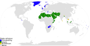
 Countries with state religions

- Article(s)
- Dozens of pages on many projects
- Request
- See discussion at WP:HD (current link) section "Extra dot on file". If this map is viewed at 300px resolution or smaller (including the 120px appearing here), there's a dot in mainland Nunavut that doesn't belong. (This map's supposed to show entire countries by a certain status, not little spots of subnational jurisdictions.) If you view the map at a fuller resolution, it doesn't appear at all, e.g. look at the 600px version. Is there some way to remove this dot entirely, so that it doesn't appear at 300px? Again, I don't know much about SVGs and have no idea how to fix this. Nyttend (talk) 01:00, 26 March 2019 (UTC)
- Discussion
![]() Done (There was a transparent rectangle near Hudson Bay, which appeared on the thumbnails for some reason.) RobinLeicester (talk) 23:16, 23 April 2019 (UTC)
Done (There was a transparent rectangle near Hudson Bay, which appeared on the thumbnails for some reason.) RobinLeicester (talk) 23:16, 23 April 2019 (UTC)
Update Map
-
 Map
Map

- Article(s)
- International Renewable Energy Agency
- Request
- Canada joined in January and should be added: [1] -- 91.114.188.0 (talk) 12:49, 20 March 2019 (UTC)
- Discussion
- @Joe, I have updated map as per request.Arjunaraoc (talk) 00:04, 11 April 2019 (UTC)
![]() Done --Arjunaraoc (talk) 04:25, 25 April 2019 (UTC)
Done --Arjunaraoc (talk) 04:25, 25 April 2019 (UTC)
Map of a house and surrounding area?
-
Close-up of embassy, showing waste ground and swimming pool
-
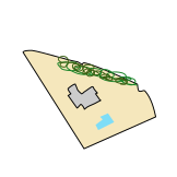
 Map of Madrid to be customised

- Article(s)
- Raid on North Korea's embassy in Madrid
- Request
- Hope two requests together isn't greedy. I'd like a simplified map of the Gmaps detail, if possible, showing the outline of the house, pine trees, swimming pool and the surrounding waste ground. And the entrance, which is on the main road just where the crossing is. The second one is a more general map of Madrid: but I guess a new one doesn't have to be done, this one can be customised? It currently shows parks (in green), but if they could be removed, we could put a few landmarks in that are mentioned in the article—the NK embassy, of course, but also that of SK, and the High Court. Although I need to find out where they are first. Hope this is easier than it sounds! Cheers, -- ——SerialNumber54129 15:28, 5 April 2019 (UTC)
- Discussion

- @Serial Number 54129: For the second request, rather than customize a map, why not use the {{OSM Location map}} template? It is fairly flexible (see Chinatown, San Francisco#Geography and location for a slightly more complex example) and multiple points of interest could be added as an overlay to OpenStreetMap data. I've put in an example for Madrid here. Cheers, Mliu92 (talk) 20:05, 8 April 2019 (UTC)
- Cheers, Mliu92 that would be great, thanks for the suggestion! Would it work in the switcher template, d'you know? ——SerialNumber54129 08:23, 25 April 2019 (UTC)

- Serial Number 54129, I have done a quick sketch map of the embassy and grounds, used as an overlay along with some labels, onto OSM Location map. You can edit and add to the individual points and labels within the template, but the sketch map was done by me on CorelDraw, so if that needs adjusting, it has to be done on the source svg overlay now on wikimedia commons. RobinLeicester (talk) 14:43, 24 April 2019 (UTC)
- Looks good, thanks RobinLeicester! Wot should I do now? ——SerialNumber54129 08:23, 25 April 2019 (UTC)
- Serial Number 54129, You can add the two maps to the article by copying the template code (when you edit this section you will see each map starts with
{{OSM Location mapand ends with}}). You should then paste each map code-list into the point in your article where it makes most sense, and review/edit the captions and labels to ensure they match the article terminology etc. Also, you will see the bigger map has a 'float=right' line, and the smaller one is currently set to 'left'. You could alter these to match which side of the page you want them. Cheers, RobinLeicester (talk) 16:47, 25 April 2019 (UTC)
Ireland Relief Map - 2014 Changes
{{resolved}}

- Article(s)
- Any article this map already features on.
- Request
- Okay, the above map could do with a few updates, in accordance with the changes brought about by the Irish Local Government Reform Act 2014, including:
1) The removal of the former border between North Tipperary and South Tipperary, which were merged into a single entity of County Tipperary under the Act.
2) The removal of the former border of the Limerick City Council area, which the Act merged with the area covered by Limerick County Council to form a single entity under the name of Limerick City and County Council.
3) The removal of the former border of the Waterford City Council area, which was merged with the area covered by Waterford County Council in order to form a single entity under the name of Waterford City and County Council under the Act.
Thanks. Snow Lion Fenian (talk) 20:52, 24 May 2019 (UTC)
- Discussion
![]() Done RaviC (talk) 12:37, 26 May 2019 (UTC)
Done RaviC (talk) 12:37, 26 May 2019 (UTC)
- @RaviC: Great work, and thanks for doing this. Snow Lion Fenian (talk) 13:30, 26 May 2019 (UTC)
Trans-Canada Highway
-
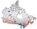 Erreur au Québec

- Article(s)
- Trans-Canada Highway
- Request
- Inaccurate map of the Trans-Canada Highway which needs to be corrected in a few spots, as there are extra loops and stubs which should not be there.
(1) In Quebec, where the highway is tracking northeasterly along the St. Lawrence River, the "lower" route should be marked only to the point where the highway swerves east toward New Brunswick; the rest of it past that turn, and the entire "upper route", inclusive of the points where the highway cuts across the St. Lawrence, are not TCH at all.
(2) In Nova Scotia, the little "stub" handle that's jutting out from the Canso Causeway and looping back down toward Halifax is also not TCH.
(3) In British Columbia, while there is a piece of the TCH on Haida Gwaii, it's marked incorrectly: it should be vertical partway down the east side of the island, not horizontal across the top.
If this isn't clear enough direction, I can reupload a temporary version with the routes that need to be removed marked out. May as well convert it to SVG format at the same time, obviously, but the errors need to be corrected in the process. -- Bearcat (talk) 23:26, 22 April 2019 (UTC) - Discussion
@Bearcat: The map above is a PNG, and I'm having a difficult time tracking down data to recreate this map. Will try with OSM data soon. (I'll post here when I start working on it, if someone else sees this go for it.) SportingFlyer T·C 04:43, 27 April 2019 (UTC)