
Wikipedia:Graphics Lab/Map workshop/Archive/2017/Sep 2017
| This page is an archive. Do not edit the contents of this page. Please direct any additional comments to the current main page. |

Fall of Constantinople

- Article(s)
- Fall of Constantinople
- Request
- please remove border… -- Kintetsubuffalo (talk) 14:21, 31 May 2017 (UTC)
- Graphist opinion(s)
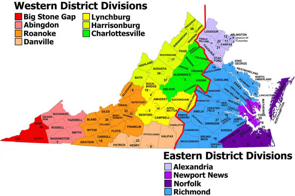
US federal courts in Virginia
-
 SVG base map

- Article(s)
- United States District Court for the Eastern District of Virginia, United States District Court for the Western District of Virginia
- Request
- This map is already in both articles, but it's crummy (a JPG, not a PNG or an SVG), and the lack of sourcing really means that it should be deleted. Could you make a replacement, using File:Map of Virginia Counties and Independent Cities.svg as your base? I can't do it, since color tweaks are needed, and I don't see any hexadecimal references in the SVG source code. I'd appreciate it if you'd:
- Label all the cities by their names (or leave the current numbers and number-key in place), and leave the current county name labels in place.
- Draw a thick link between the eastern and western districts.
- Select a different color for each district division, and apply that color to all the counties and all the cities within that division.
- Thank you! Nyttend (talk) 04:06, 3 June 2017 (UTC)
- Graphist opinion(s)
![]() Request taken by Goran tek-en (talk) 18:31, 24 June 2017 (UTC).
Request taken by Goran tek-en (talk) 18:31, 24 June 2017 (UTC).
@Nyttend: Now there is a draft for you. You should check it and all the texts also as I had to rewrite some of them. Give me feedback, thanks. --Goran tek-en (talk) 21:42, 2 July 2017 (UTC)
- Thank you! Several comments on this draft:
- Could you switch colors for the Harrisonburg and Abingdon divisions? Maybe it's because of my colorblindness, but I see the colors for Abingdon and Big Stone Gap as identical to each other, and the same is true for Harrisonburg and Lynchburg.
- Could you shrink the font size for the labels for Appomattox and Buckingham counties? The labels are hard to read because of their length.
- The key misspells the names of two cities, Colonial Heights and Waynesboro, and in the color key for the divisions, Big Stone Gap has a capitalisation mistake, "Big stone Gap". Probably capitalising district, i.e. "Eastern District" and "Western District", is also more correct.
- One county (Arlington, in the northeast) is wrongly colored as a city; it needs to have the coloring for the Alexandria Division.
- Three cities in the southeast corner (Suffolk, Chesapeake, and Virginia Beach) incorrectly have names as well as numbers (and Virginia Beach is mislabelled as Norfolk); could you remove the names? These three are large, since entire counties became cities; that's probably what confused you.
- A bunch of cities are erroneously not colored as cities:
- Suffolk, Chesapeake, Virginia Beach, Norfolk, Portsmouth (all in the Norfolk Division)
- Poquoson, Hampton, Newport News, and Williamsburg (all in the Newport News Division)
- Colonial Heights and Hopewell (in the Richmond Division)
- Fredericksburg (boundary between Richmond and Alexandria divisions)
- Aside from those bits, all of which should be simple fixes, I have no further requests for changes; I like the layout, as it's clean and simple. Nyttend (talk) 22:24, 2 July 2017 (UTC)
- PS, instead of recoloring these cities, is it possible to remove the city coloring and just give each city the coloring for its judicial division, as if it were a county? If you recolored the clumps of cities in the southeast, the whole thing would be less understandable (Newport News Division would appear to consist of just three counties, and Norfolk Division would appear to be split into two sections that are very distant from each other), and as long as each location is properly labelled, the distinction between cities and counties isn't particularly relevant for this topic. Right now, it's easy to see that Fredericksburg is in the Richmond division, but if you gave it a city coloring, I wouldn't know which division it went with. Nyttend (talk) 00:40, 4 July 2017 (UTC)
- @Nyttend: For #5 I can't find any city areas for Suffolk, Chesapeake, Virginia Beach so I have looked at OSM. You have to correct me if they are wrong.
- It's really hard to get the colors working for people with color issues when they are so many. I have tried but you have to tell me what to change. Due to the amount of text it's also hard to use pattern.
- New draft for you. You probably have to reload the page to get the new version. Give me feedback, thanks. --Goran tek-en (talk) 19:38, 4 July 2017 (UTC)
- Thanks! At least for me, the colors are easy now; the only ones that are even close are Richmond and Danville, and even if they weren't distinguishable by color, the line between Eastern and Western makes it obvious that they're separate. And in general, remember that light/dark is always useful, and you've frequently put a light color next to a dark color, so I'd say don't worry about it more. For Suffolk, Chesapeake, and Virginia Beach, the whole thing is the city (if you're curious, see Nansemond County, Virginia, Norfolk County, Virginia, and Princess Anne County, Virginia respectively); there is no city core amidst a county, nothing comparable to Charlottesville enclaved in Albemarle County, for example. So if you could just remove the little blobs next to 34, 5, and 35, without removing the numbers themselves, I think it would be ideal. Nyttend (talk) 22:08, 4 July 2017 (UTC)
- @Nyttend: Great, can you provide me with a link or place that I can put as source otherwise it will be the same problem again. --Goran tek-en (talk) 18:07, 6 July 2017 (UTC)
- Source? I don't know what "same problem" you mean. By the way, several cities of the Peninsula have the wrong color (I failed to notice this before); the Newport News division includes the counties currently marked as such, but it should also include York and James City Counties, as well as cities #15, #23, #27, and #37. Nyttend (talk) 21:55, 6 July 2017 (UTC)
- Source? I don't know what "same problem" you mean. By the way, several cities of the Peninsula have the wrong color (I failed to notice this before); the Newport News division includes the counties currently marked as such, but it should also include York and James City Counties, as well as cities #15, #23, #27, and #37. Nyttend (talk) 21:55, 6 July 2017 (UTC)
- @Nyttend: Great, can you provide me with a link or place that I can put as source otherwise it will be the same problem again. --Goran tek-en (talk) 18:07, 6 July 2017 (UTC)
- Thanks! At least for me, the colors are easy now; the only ones that are even close are Richmond and Danville, and even if they weren't distinguishable by color, the line between Eastern and Western makes it obvious that they're separate. And in general, remember that light/dark is always useful, and you've frequently put a light color next to a dark color, so I'd say don't worry about it more. For Suffolk, Chesapeake, and Virginia Beach, the whole thing is the city (if you're curious, see Nansemond County, Virginia, Norfolk County, Virginia, and Princess Anne County, Virginia respectively); there is no city core amidst a county, nothing comparable to Charlottesville enclaved in Albemarle County, for example. So if you could just remove the little blobs next to 34, 5, and 35, without removing the numbers themselves, I think it would be ideal. Nyttend (talk) 22:08, 4 July 2017 (UTC)
- @Nyttend: For #5 I can't find any city areas for Suffolk, Chesapeake, Virginia Beach so I have looked at OSM. You have to correct me if they are wrong.
@Nyttend: You wrote your self at the beginning of this request that the image you wanted a new instead of, lacked a source and therefore it might be deleted "and the lack of sourcing really means that it should be deleted." So we need a source for this new one instead.
The wrong coloring is my mistake, sorry. I have changed but I have problems with my ftp right now so I can't show you a new draft right now, will be back. --Goran tek-en (talk) 16:36, 8 July 2017 (UTC)
- Um, where did you get the base image? Is it 100% an own work, or did you derive it from some other source, such as File:Map of Virginia Counties and Independent Cities.svg that I suggested? Correctly listing your source is your responsibility, not mine. Nyttend (talk) 04:10, 9 July 2017 (UTC)
- @Nyttend: No I believe you misunderstand me. is the source map and that is you who have added that. That is the one that lacks a source, where it comes from. I can't create/upload this new map without giving a free reliable source on where that information/knowledge came from. It is you who has requested this, you have the knowledge and has to provide me with that source.
- For the base map, which I then make a derivat of, I will provide the link for. --Goran tek-en (talk) 13:19, 9 July 2017 (UTC)
- @Goran tek-en: Information doesn't have to come from a free source. Only copyrightable works that you use, i.e. the base map. It's better if the data a map is based on is cited to an RS, but it's by no means necessary to upload it to Commons. Often the map simply represents the (sourced) information in its article in a visual form and so doesn't need separate citation. In any case the information in this map is easily verified [1][2]. – Joe (talk) 14:14, 9 July 2017 (UTC)
- @Joe Roe: Thanks, that is what I need, a link to the information and this is in the public domain. What I meant was if I use a map as source, to my understanding, it has to be free otherwise I can't use it as source. A source can be text also but that also has to be free to be used if I'm not totally wrong. --Goran tek-en (talk) 16:41, 9 July 2017 (UTC)
- @Goran tek-en: Information doesn't have to come from a free source. Only copyrightable works that you use, i.e. the base map. It's better if the data a map is based on is cited to an RS, but it's by no means necessary to upload it to Commons. Often the map simply represents the (sourced) information in its article in a visual form and so doesn't need separate citation. In any case the information in this map is easily verified [1][2]. – Joe (talk) 14:14, 9 July 2017 (UTC)
- @Nyttend: No I believe you misunderstand me. is the source map and that is you who have added that. That is the one that lacks a source, where it comes from. I can't create/upload this new map without giving a free reliable source on where that information/knowledge came from. It is you who has requested this, you have the knowledge and has to provide me with that source.
I'm not sure you are right. I can't just take any copyrighted text and use that as I want, no way, deritave works from text at commons. You write Information can come from copyrighted sources, whether that's text, a map, an image, or anything else. but to me that is not correct. I can't look at a copyrighted map and make a version of it for commons for instance and put up that as a source, I can't. I can't use google maps as a source but I can use OpenStreetMap. Maybe we are talking about different things, I think there is a difference between wikipedia and commons Copyright_rules_by_subject_matter, Threshold_of_originality. --Goran tek-en (talk) 18:22, 9 July 2017 (UTC)
- I think you have misunderstood. The analogy with text is helpful. We can't copy text straight into Wikipedia articles. However, if we learn from a source that, for example, the federal courts in Virginia are split into two districts, it is okay to re-express that in your own words. Similarly, we can't copy a map – whether that's copy-and-pasting, tracing or redrawing. But if you learn from a map which counties are in the Southern District, it is okay to use that information when drawing your own map. As far as I know Wikipedia and Commons are on the same page in that regard, because it's a basic principle of copyright that facts and information aren't copyrightable, only original expressions of them. – Joe (talk) 21:05, 9 July 2017 (UTC)
- Joe Roe is correct. The problem with the original image is that it claims to be a PD-USGov work, but there's really no source for the map itself, so it needs to be deleted with Commons:Template:Nsd. If the map on Joe Roe's "easily verified" links were a nonfree image, you could still use it as a source of information by taking a free map and coloring the respective cities and counties to match that other image, just as you could use Google Maps as a source of information. C:Commons:Derivative works#Text is talking mostly about copying the text itself, e.g. making a JPG that includes a few paragraphs of nonfree text. Nyttend (talk) 21:20, 9 July 2017 (UTC)
- Yes that is what I mean, you can't take a text or image straight of. I can't make a new map based on a copyrighted without making it different and adding my own "stuff.
- There is some differences between commons and wikipedia. Look under this paragraph "Fair use" allowed on some Wikimedia projects on the linked page.
- What I have learned here is that I can't use Google maps as base and i.e hand trace from it to make a map, that's like making a copy, not using it's information. On this page Free_media_resources/Map there is a list of free map resources that we can use.
- @Nyttend: Now you can find the map here File:US federal courts in Virginia.svg. Check so everything is OK, if not just contact me, thanks. --Goran tek-en (talk) 17:50, 10 July 2017 (UTC)
- Thanks very much! I found one error — Williamsburg, city #37, is white, but it should have the color of the Newport News Division. I downloaded the file and tried to fix it in Notepad, but I can't find a reference to it at all in the coding; the only appearance of "Williamsburg" is at the end, in the coding for the key, unlike for other cities, in which the city name also appears in the coding for the city's boundary and color. I guess I'll have to ask you to fix it in an image-based editor, since Notepad's the only way I have to edit SVGs. Nyttend (talk) 21:19, 10 July 2017 (UTC)
- Yes that is what I mean, you can't take a text or image straight of. I can't make a new map based on a copyrighted without making it different and adding my own "stuff.
- Joe Roe is correct. The problem with the original image is that it claims to be a PD-USGov work, but there's really no source for the map itself, so it needs to be deleted with Commons:Template:Nsd. If the map on Joe Roe's "easily verified" links were a nonfree image, you could still use it as a source of information by taking a free map and coloring the respective cities and counties to match that other image, just as you could use Google Maps as a source of information. C:Commons:Derivative works#Text is talking mostly about copying the text itself, e.g. making a JPG that includes a few paragraphs of nonfree text. Nyttend (talk) 21:20, 9 July 2017 (UTC)
![]() Done
@Nyttend: I will fix that right away. The reason for me to put out who requested an image is that when someone has another idea of how it should be (border is wrong, that town should have that color etc) they turn to me and I have zero knowledge of this subject, you have the knowledge, so they should turn to you for discussions like that. --Goran tek-en (talk) 17:05, 11 July 2017 (UTC)
Done
@Nyttend: I will fix that right away. The reason for me to put out who requested an image is that when someone has another idea of how it should be (border is wrong, that town should have that color etc) they turn to me and I have zero knowledge of this subject, you have the knowledge, so they should turn to you for discussions like that. --Goran tek-en (talk) 17:05, 11 July 2017 (UTC)
- [Forgot to respond here earlier] Thank you! I removed myself because I thought you believed that you had to attribute me as one of the authors, but now that I understand your meaning, I can see that it makes complete sense. Nyttend (talk) 01:05, 12 July 2017 (UTC)
Iowa court map
-
 Ugly map
 -
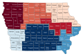 New version


- Article(s)
- United States District Court for the Northern District of Iowa
- Request
- This is an ugly federal map that I think was made in Paint in 5 minutes. Can you create a SVG version that will be better for this? 24.164.180.177 (talk) 18:22, 4 June 2017 (UTC)
- Graphist opinion(s)
 Done It seemed silly to have separate maps for the Northern and Southern Districts, so I've created a new SVG version showing the divisions of both (as Goran tek-en has done for Virginia above) and added it to both articles. – Joe (talk) 12:18, 9 July 2017 (UTC)
Excellentitious 67.245.222.116 (talk) 00:43, 25 August 2017 (UTC)
Plastic bag legislation map

- Article(s)
- Phase-out of lightweight plastic bags
- Request
- Color in Colombia in yellow since a country wide tax has been applied for the use of plastic bags and color in Argentina in purple since some municipalities have banned the use of plastic bags. Thank you. -- Anfecaro (talk) 14:46, 30 June 2017 (EST)
- Graphist opinion(s)
![]() Done Houdinipeter (talk) 02:26, 1 July 2017 (UTC)
Done Houdinipeter (talk) 02:26, 1 July 2017 (UTC)
Location map of Caracas
_2.svg)
- Article(s)
- Caracas
- Capital District (Venezuela)
- Request
- Really need a pushpin map for Caracas as it is one of the largest cities in South America.--ZiaLater (talk) 08:31, 4 July 2017 (UTC)
- Actually, I may have found one here.--ZiaLater (talk) 09:16, 4 July 2017 (UTC)
- Graphist opinion(s)
@ZiaLater: If the map you found was OK please put this code {{resolved|1=~~~~}} on the upper part of this request so it can be archived, thanks. --Goran tek-en (talk) 17:04, 12 July 2017 (UTC)
Map of Newmarket Canal
- Article(s)
- Newmarket Canal
- Request
- There is a map in the article, a screen shot of OpenMaps. It shows only a short section of the canal area, and does not indicate the route with any sort of path marker. Maury Markowitz (talk) 13:29, 15 July 2017 (UTC)
- Graphist opinion(s)
@Maury Markowitz: I can help you with that but you have provide me with a source for canal and the route so I can see or understand it. This is your subject I have zero knowledge of it so you have to explain exactly what you want.
- What else do you want in the map, street's, railroads, and etc, thanks. --Goran tek-en (talk) 14:35, 15 July 2017 (UTC)
- I've looked everywhere for an online version of the map, without any luck. The only one I have is in printed form from the University of Toronto. However, the route is very easy to describe. It starts on the north side of Davis Drive in Newmarket, and follows the Holland River to Cook's Bay. That is it! The only other information of interest for this article would be the railroad, which did exist at that time, and the towns of Holland Landing and Newmarket. The three locks and the turning basin would also need to be marked, I can indicate them on an image if you like. Maury Markowitz (talk) 11:52, 17 July 2017 (UTC)
Maury Markowitz (talk) 11:52, 17 July 2017 (UTC)
![]() Request taken by Goran tek-en (talk) 15:11, 17 July 2017 (UTC).
Request taken by Goran tek-en (talk) 15:11, 17 July 2017 (UTC).
- Thinking on this further, perhaps the "base map" would be a highly muted topo map of the area? One that uses shading for various altitudes. The canal route is much lower than the surrounding land, and that might make it stand out. Maury Markowitz (talk) 15:28, 17 July 2017 (UTC)
- And I see I did not answer one of your questions... there are several roads that would be useful - Young street, especially as it enters Holland Landing, Bayview Avenue/Concession 2, Green Lane and Davis Drive. These are the location of the locks, bridges and turning basin. Maury Markowitz (talk) 15:30, 17 July 2017 (UTC)
- @Maury Markowitz: I want you to look at this image. I want you to control so I got it right, the start and stop has red white x, the two towns is the black lines and the red line is just the route besides the river. I want you to tell me if this is all correct or what to change. Please ping me as the watch doesn't work all the time, thanks. --Goran tek-en (talk) 19:37, 17 July 2017 (UTC)
You have it exactly, that is the general route. I can point to the location of the locks or just describe them here. Maury Markowitz (talk) 19:56, 17 July 2017 (UTC)
- @Maury Markowitz: Now there are two drafts for you to look at. Check to see if everything is correct and tell me what you want changed, removed, added or what ever. I have added the turning bridge but if you don't want just tell me.
- This is not really a map, it's almost more like an illustration because it shows a period of time and things change during that time. I have just made assumptions for the size of the towns and the green areas and wetlands are from a current map. Tell me which version you want, thanks.
- The drafts are png versions of the svg drawing I will upload when we are done. --Goran tek-en (talk) 20:58, 20 July 2017 (UTC)
Most excellent! The only suggestion I have is that the lock icons are somewhat hard to see, perhaps make them red as well? Maury Markowitz (talk) 11:50, 24 July 2017 (UTC)
- @Maury Markowitz: I will edit the locks but you have to tell me which version you want?
- Do you know which way the water flows, from the lake or towards the lake? --Goran tek-en (talk) 15:46, 24 July 2017 (UTC)
- Oh I prefer the red line version. The water runs towards the lake - to the north. Maury Markowitz (talk) 17:51, 24 July 2017 (UTC)
- @Maury Markowitz: I will need the following;
- Name of the file
- Description
- Category/ies at commons
- to be able to upload it at commons, thanks. --Goran tek-en (talk) 18:01, 25 July 2017 (UTC)
- I think "Newmarket_Canal_map" seems like a good name! I can fill out the description if you put in a placeholder for now. Category:Trent–Severn_Waterway and Category:Canals in Ontario should be OK. Maury Markowitz (talk) 19:10, 25 July 2017 (UTC)
- @Maury Markowitz: I will need the following;
- Oh I prefer the red line version. The water runs towards the lake - to the north. Maury Markowitz (talk) 17:51, 24 July 2017 (UTC)
@Maury Markowitz: Now you can find it here Commons:file:Newmarket Canal map.svg. If you are happy with this please put the code {{resolved|1=~~~~}} on this page so it can be archived, thanks. --Goran tek-en (talk) 16:04, 26 July 2017 (UTC)
![]() Done
Done
Looks great!
Map of Borneo
-
 Map of Borneo

- Article(s)
- Brunei (and many others)
- Request
- A reader contacted us (ticket:2017061010002365), pointing out that on this map File:Control_of_the_island_of_Borneo.png, a state is identified as North Borneo, but it was renamed Sabah some time ago. See also North Borneo. The creator @Muffin Wizard: hasn't edited since 2015 so I am hoping someone here can take up the correction. -- S Philbrick(Talk) 16:25, 16 July 2017 (UTC)
- Graphist opinion(s)
![]() Done Maproom (talk) 20:02, 16 July 2017 (UTC)
Done Maproom (talk) 20:02, 16 July 2017 (UTC)
- @Maproom: Thank-you!!--S Philbrick(Talk) 18:33, 17 July 2017 (UTC)
Conversion of this image, representing a hand written map into a proper map
-
 German Operations of Communication intelligence units (intercept companies) in Balkan operation February 1941.

- Article(s)
- General der Nachrichtenaufklärung
- Request
- Hi, This is a map of German intercept, i.e radio intelligence operations during the German operation in the Balkans in World War 2. It was hand drawn apparently by General Albert Praun, after the war as part of TICOM operations homework, and I'm looking to convert it to a modern looking map, with the detail provided. Although not an expert on this, the image seems to show the locations of each intercept company, by the wee antenna, aerial that is shown above the box. Notice the wee lines above the boxes, which I think mean seniority or importance. The lines are direction of listening, or direction finding, and the two lines represent the range of the intercept kit. INTCP is intercept, I guess. I don't know what the mbl means, but worth putting in, until I can find what it means. I can put a note on the image caption. This map, when completed, will go in this section, General der Nachrichtenaufklärung#German Campaign in the Balkans. Thanks. scope_creep (talk) 17:44, 22 July 2017 (UTC)
- Graphist opinion(s)
![]() Request taken by Goran tek-en (talk) 22:22, 23 July 2017 (UTC).
Request taken by Goran tek-en (talk) 22:22, 23 July 2017 (UTC).
@Scope creep: This map doesn't correspond to the maps we have of that region as it's hand drawn. So I want you to tell me;
- do you want me to just redraw it as it is or should I convey it to an "ordinary" map?
- if you want me to convey it, is it OK to use a location map as base map? --Goran tek-en (talk) 16:06, 24 July 2017 (UTC)
- I'm not too sure, It won't be a second world war map,but I guess you have to work with what you have. Is it possible to try it as a location map, and see what it looks like. If it's not close to the original, then do a redraw? scope_creep (talk) 16:24, 24 July 2017 (UTC)
- OK, will do. --Goran tek-en (talk) 17:21, 24 July 2017 (UTC)
- @Scope creep: Now there is a draft for you to look at. Check everything, especially the borders in the eastern part. I don't really understand them compared to a map. Give me feedback on this, anything goes, thanks.
- This draft is a png version of the svg file. --Goran tek-en (talk) 18:28, 26 July 2017 (UTC)
- Hi Goran tek-en, excellent. Really good work. I'll check it tomorrow, and if it is fully representative, then I'll sign it off. Much much better than I thought I was going to get. Thanks. I'll be able to be get a really good visually representative article. scope_creep (talk) 18:35, 26 July 2017 (UTC)
- @Scope creep: OK let me know tomorrow and if it's OK I will need the following;
- Name: Operations of German Communication Intelligence Units against the Balkans and Near East 1941
- Description: German intercept operations in the Balkans during Battle of Greece during 1941.
- Categories: Signals intelligence of World War II, Military history of Germany during World War II, German intercept operations during World War II,
- German Radio Communication Intelligence operation in Balkans 1941, History of radio operations of Germany, History of radio intercept operations.
- to be able to upload it at commons. --Goran tek-en (talk) 20:35, 26 July 2017 (UTC)
- @Scope creep: OK let me know tomorrow and if it's OK I will need the following;
- Hi Goran tek-en, excellent. Really good work. I'll check it tomorrow, and if it is fully representative, then I'll sign it off. Much much better than I thought I was going to get. Thanks. I'll be able to be get a really good visually representative article. scope_creep (talk) 18:35, 26 July 2017 (UTC)
- @Scope creep: Now there is a draft for you to look at. Check everything, especially the borders in the eastern part. I don't really understand them compared to a map. Give me feedback on this, anything goes, thanks.
- OK, will do. --Goran tek-en (talk) 17:21, 24 July 2017 (UTC)
- There is a couple of mistakes. Graz and Bacău are spelt wrong. Nothing else, apart from that. scope_creep (talk) 15:03, 27 July 2017 (UTC)
- Hi Goran tek-en, I updated the name, put in German, make it more specific. I don't know if I've lost the window. Either way suits. I'm looking forward to it.scope_creep (talk) 22:16, 27 July 2017 (UTC)
@Scope creep: Now you can find it here Commons:file:Operations of German Communication Intelligence Units against the Balkans and Near East 1941.svg.
Only this category existed: Military history of Germany during World War II.
If you are happy with this please put the code {{resolved|1=~~~~}} on this request so it can be archived, thanks. --Goran tek-en (talk) 16:54, 28 July 2017 (UTC)
- Excellent work!.
![]() Done
Done
Kingdom of Hungary
-
 Kingdom of Hungary with coloured and tagged counties
 -
 Desired map layout for current Hungary


- Article(s)
- Kenyérmezei csata, Lamacsi ütközet, others
- Request
- We would need something similar like this map in Commons for 5 years now, and our friends were not smart enough to create one with historical Hungary that we could use to place pointers on. I've found another similar one, but I would need it without colouring and county names. May I ask your kind help to create one for the Kingdom of Hungary around 1914? Drkazmer
 Just tell me... 10:49, 26 July 2017 (UTC)
 - Graphist opinion(s)
![]() Request taken by Goran tek-en (talk) 19:18, 26 July 2017 (UTC).
Request taken by Goran tek-en (talk) 19:18, 26 July 2017 (UTC).
@Drkazmer: Now there is a draft for you to look at, give me feedback.
Once we are done I will need the following;
- Name of the file
- Description
- Category/ies at commons
to be able to upload it at commons. --Goran tek-en (talk) 19:18, 26 July 2017 (UTC)
- For my purposes, it's just perfect. I'd like to note that the locator map using the picture that I have linked is having some problems with the coordinates in the template (as seen in the description). For me it seems that cities are displayed more to the north than their actual position.
- As name I would suggest Kingdom of Hungary locator map, or something similar. Regarding the categories I would keep the ones of the old file: Maps of counties in the Kingdom of Hungary, Maps showing 19th-century history, SVG maps of Hungary, for the locator map: Locator maps of counties in the Kingdom of Hungary. Drkazmer Just tell me... 08:18, 27 July 2017 (UTC)
- @Drkazmer: There is a difference between Location and Locator map Wikipedia:WikiProject_Maps/Conventions#Overview and to me this is a Location map.
- Now you can find it here Commons:file:Kingdom of Hungary location.svg. If you are happy with this please put the code
{{resolved|1=~~~~}}on this request so it can be archived, thanks. If you want me something please ping me as the watch doesn't work all the time, thanks. --Goran tek-en (talk) 13:29, 29 July 2017 (UTC) Done
- @Drkazmer: There is a difference between Location and Locator map Wikipedia:WikiProject_Maps/Conventions#Overview and to me this is a Location map.
- Thanks for correcting! Who may help with the coordinates? – Drkazmer
 Resolved Just tell me... 10:53, 2 August 2017 (UTC)
- Thanks for correcting! Who may help with the coordinates?
Three German intercept operation maps during world war II.


- Article(s)
- General der Nachrichtenaufklärung
- Request
- Please mapify the three images from the General Albert Praun document, found at:
https://archive.org/details/41748999078819
The maps representing intercept operations for the Germinal Sig Int organization, and are hand drawn by General Praun himself, who was head of Signal Intelligence for the German Army during the second world war. Straight off the press, as part of homework for the TICOM org. Thanks. scope_creep (talk) 22:02, 28 July 2017 (UTC)
- I have changed the document version to one stored at archive.org which has much clearer images. It can be downloaded in pdf format, which is located at Download options below the image. scope_creep (talk) 10:19, 29 July 2017 (UTC)
- I have looked at the images. I screen printed them, resulting in them being a bit blurry. Pleaise refer to the document, which is in the public domain, for full size. scope_creep (talk) 10:31, 29 July 2017 (UTC)
- Graphist opinion(s)
![]() Request taken by Goran tek-en (talk) 14:03, 30 July 2017 (UTC).
Request taken by Goran tek-en (talk) 14:03, 30 July 2017 (UTC).
@Scope creep: It would help me a lot if you told me on which pages those maps can be found, there are 294 pages in that pdf file, thanks. --Goran tek-en (talk) 14:03, 30 July 2017 (UTC)
Hi Goran tek-en, thank you for working on it. They are from the following pages.
- First one, page 20, pdf 30
- Second , page 21, pdf 31
- Third , page 39, pdf 53
scope_creep (talk) 14:18, 30 July 2017 (UTC)
- @Scope creep: Thanks for that. Can you describe roughly what the images show, it's hard to make an understandable map without knowing anything about them. --Goran tek-en (talk) 15:43, 31 July 2017 (UTC)
- Hi Goran tek-en
- Map 1 is the intercept operations for Germany during WW2, the invasion of the west into France, Belgium and Netherlands, which happened very quickly. It is a range in time, which covers the campaign. The first map of map 1 show intercept operations during Blitzkrieg. There is three things in operation, Long Range Intelligence Company. That is the square boxes, with the straight lines, showing direction of intercept. OKH is the boss Oberkommando des Heeres. The dashed lines are baselines, a vector essentially for direction finding, of signals to intercept. The horizontal dashed lines represent the control area of Close Range Intelligence Company. These short range intercept companies, operation 10-20 miles behind the front lines. Often getting shot or captured. On the first map there fixed intercept station, big operation, that move forward. The horizontal dashed lines show the area under intercept control. Everything in there is vacuumed up. Note there is two different types of black lines, thin and thick ones. Thin represents Chain of Command, thick represents long range intercept. A close examination of the map, will surface it, it will appear if you look. The second map of the first map, represent the invasion finished. Evaluation centres, Signal Intelligence Regiment (KONA)#Signal Intelligence Evaluation Centre have opened up, which are represented by A, B, C boxes. Most links are thin, meaning chain of command. Long range intercept units have left for new battle in east. The 5 'xxxxx' on top of eval box. Don't know what it is? Please keep it. I notice there are two boxes, each one has a separate function for sure. I'll read the docs. Got it, the XXXX, on A, b and C, represent A, e.g Army Group A, is an army, with an attached evaluation centre providing intelligence.
- Second map: for map 1 and 2 show a static situation, with eval centres moving in second map. During this time, Hitler is thinking about invading old blighty. So still active intercept companies listening close the the coast. By map 2, evaluation centre C, which does Cryptanalysis, trying to crack intercepts in decrypts, has lot its Army Group. I think has moved to the east, for the Balkans invasion, leaving 2 left. All the stuff is to the coast.
- Third map: This is the listening of British communication, from the French coast, for the setup of the invasion of blighty, which never happened. Note the last map has dashes above the boxes. Please put that in. scope_creep (talk) 22:42, 31 July 2017 (UTC)
- All the maps show position, order of battle, subordination, classification, direction, direction finding, movement in time.
- Hope that helps. scope_creep (talk) 22:28, 31 July 2017 (UTC)
- mbl means mobile of course. Never knew that yesterday. scope_creep (talk) 22:50, 31 July 2017 (UTC)
1-1
- @Scope creep: Now I have made a draft of the left map of 1German_intecept_operations_Norway%2C_Denmark%2C_Belgium_1939-jan_1940. I'm not sure I have understood everything but your explanation is very helpful. I want you to check this draft and tell me what to change before I continue with the others.
- Also I want to know if you want both left and right map in the same map or as two separate?
- This is a png version of the svg file, pleas ping me, thanks. --Goran tek-en (talk) 21:59, 1 August 2017 (UTC)
- Separate maps please. They must range in time. scope_creep (talk) 00:10, 2 August 2017 (UTC)
- Crazy. I'll check that tomorrow and sign if off. Excellent work in a short time. Coolio. scope_creep (talk) 00:27, 2 August 2017 (UTC)
- @Scope creep: Now I have made a draft of the left map of 1German_intecept_operations_Norway%2C_Denmark%2C_Belgium_1939-jan_1940. I'm not sure I have understood everything but your explanation is very helpful. I want you to check this draft and tell me what to change before I continue with the others.
Hi Goran tek-en, I saw your site and passed to my nieces, who seem to be into it. I've not seen stuff like that before. Is that your good self?
I found some changes, Please change the following:
- Great Britain is spelt wrong. Great Britain.
- Arian to Arlon
- Enskirchen to Euskirchen
- Change Frankfurt to Frankfurt am Main (if you can fit it in. If not..)
- Laguyon to Longuyon
Legend (Starting at top)
- XXXXX Symbol with square box change to: Army Group 3 with attached Signal Intelligence Evaluation Centre #3 (NAAS)
- Square Box change to: Long Range Intelligence Company (FAK)
- Square box with lighting dash, Change to: Close Range Intelligence Company (NAK)
- Change Direction, finding to: Direction-finding baseline
- Change red lines to: Long Range Intercept operations
- Change purple designation to: Radio intelligence by intercept companies near the border.
- Please Take out the Aerial, it is possibly self evident (although it took me 2 weeks to figure it out, and you'd think you would know...), and gives the reader something to chew on.
- Please Take out OKH from the legend. It is also self evident I think, and is shown multiple times in article.
Two images for the first block is fine. I can put them next to each other in the article, I think. For this one:
Name: Operations by German Signal Intercept Units during Invasion of France and Low Countries August to October 1941. Description: Intercept units movements during Signal intelligence operations by Germany during invasion of France and low countries. Categories: Military history of Germany during World War II, German intercept operations during World War II,
scope_creep (talk) 11:20, 2 August 2017 (UTC)
- @Scope creep: I have some questions;
- If you mean this site skulpturala smycken in Swedish or sculpted jewelry in English so yes they are mine and it's my design and work.
- How do you make the grey box with text inside, I don't see any code...
- What do you mean by "Please Take out the Aerial"?
Now there is a new draft svg version, feedback, thanks. --Goran tek-en (talk) 17:29, 2 August 2017 (UTC)
Hi Goran tek-en, I've messed it up a wee bit. Can you take out the square box with Long Range Intelligence Company (FAK) next to it, in the legent, and put the: Long Range Intelligence Company (FAK) next to red Aerial symbol. The red aerials are long range guys. Never noticed it. That will be it. The rest is excellent. scope_creep (talk) 17:47, 2 August 2017 (UTC)
- @Scope creep: New draft like this, maybe you need to update the browser window, feedback. --Goran tek-en (talk) 18:11, 2 August 2017 (UTC)
It's still not right. Can you take out the middle empty white box, with the blue close top in Legend, which has Long Range Intelligence Company (FAK) written next to it and move the phrase - Long Range Intelligence Company (FAK) next to the red aerial symbol with the legend box. The problem is, is that there is no empty square box on the map. The only one that is there, is a evaluation centre no. 3. The name interception can, with the written next to it. scope_creep (talk) 18:47, 2 August 2017 (UTC)
I just refreshed the image, ping it was complete!. Perfecto. That is that one done. scope_creep (talk) 18:59, 2 August 2017 (UTC)
@Scope creep: Now you can find it here Commons:file:Operations by German Signal Intercept Units during Invasion of France and Low Countries August to October 1941.svg
This category doesn't exist: German intercept operations during World War II
![]() Done --Goran tek-en (talk) 18:21, 3 August 2017 (UTC)
Done --Goran tek-en (talk) 18:21, 3 August 2017 (UTC)
1-2
- The next is is the same gig. Except it has three armies hanging, 1-2 million men each, plus close range intercept guys moved to the coast. The Army Groups 1,2,3 have changed to Army Group A, B Cscope_creep (talk) 19:05, 2 August 2017 (UTC)
- This is info only. scope_creep (talk) 23:06, 2 August 2017 (UTC)
- @Scope creep: Now there is a draft for you to look at. Check everything and specially all the numbers as they are hard or impossible for me to read, give me feedback, thanks. --Goran tek-en (talk) 14:43, 4 August 2017 (UTC)
- This is info only. scope_creep (talk) 23:06, 2 August 2017 (UTC)
- I found out what thosr wee vertical dashes on the top of boxes meant. They mean rank as in command. 1 dash top rank, three is the third rank,and so on. They are essentially the same, so it indicates who is in command of that group and who is subordinated. Great when you know it. scope_creep (talk) 15:02, 4 August 2017 (UTC)
- Knowledge is fun. Have ju checked the draft? --Goran tek-en (talk) 16:00, 4 August 2017 (UTC)
- All fine, apart from a wee bit crowded in the middle. Can you take out the:
- Knowledge is fun. Have ju checked the draft? --Goran tek-en (talk) 16:00, 4 August 2017 (UTC)
- The two eval cen. Its a bit muddled in the centre. Can you take the top two out.
- The 25 INTCP is the 26 INTCP
- Below the 3 INTCP it is the 55 INTCP
- Can you change Frankfurt am Main back to Frankfurt (I know, but the reader can see it is Frankfurt am Main in the other map but it is crowding the centre)
- Coblenz to Koblenz (post war new name)
That's all. I'm reet, as in Newcastle right, happy. I'm going to horse in the two sections in the next couple of days. scope_creep (talk) 16:32, 4 August 2017 (UTC)
@Scope creep: New draft for you to look at. If this is OK I will need the following;
- Operations by German Signal Intercept Units during Invasion of France and Low Countries October 1939 to January 1940
- Intercept units movements during Signal intelligence operations by Germany during invasion of France and low countries.
- Germany in World War II
to be able to upload it at commons. --Goran tek-en (talk) 17:13, 5 August 2017 (UTC)
--- @Goran tek-en: It is fine. Seems ok. I have made a mistake in the naming of that last image. It is August to October 1939, NOT August to October 1941. I'll try and have it moved or renamed. scope_creep (talk) 20:37, 5 August 2017 (UTC)
- I don't seem to have the rename capability in commons. Can you please rename the previous one from:
Operations by German Signal Intercept Units during Invasion of France and Low Countries August to October 1941.svg
TO
Operations by German Signal Intercept Units during Invasion of France and Low Countries August 1939 to October 1939.svg
Thanks
scope_creep (talk) 20:47, 5 August 2017 (UTC)
- I don't have that capability but I have asked for a change. --Goran tek-en (talk) 21:40, 5 August 2017 (UTC)
- @Scope creep: Now you can find it here Commons:file:Operations by German Signal Intercept Units during Invasion of France and Low Countries October 1939 to January 1940.svg --Goran tek-en (talk) 16:32, 6 August 2017 (UTC) Done
2-1
@Scope creep: Now there is a new draft, feedback, thanks. --Goran tek-en (talk) 17:47, 6 August 2017 (UTC) Good Evening Goran tek-en. Two things.
- The 55 INTCP is the 56 INTCP
- The 67 INTCP is the 57 INTCP
- Is it possible to get Godes-berg to a single horizontal word. If bothersome, don't bother.
Apart from that, not much. Quick work, faster than I can put content in. Good chart. scope_creep (talk) 00:56, 7 August 2017 (UTC)
- @Scope creep: New draft and this time with legend, forgot before. Reload page, feedback.
- I will need the following;
- Name of the file:Operations by German Signal Intercept Units prior to Invasion of France and Low Countries February to April 1940
- Description:Intercept units movements during Signal intelligence operations by Germany during invasion of France and low countries. February to April 1940
- Germany in World War II
- to be able to upload it at commons. --Goran tek-en (talk) 17:14, 7 August 2017 (UTC)
Thanks Goran tek-en. Looking at it I never noticed they are still inside Germany at that point. The Battle of France started on the 10th May 1940 and was over 6 weeks later. So that image, is before the battle. The next image is after April 1940, which means all prep, not the battle itself. Weird. I will need to rename the previous two images. scope_creep (talk) 17:35, 7 August 2017 (UTC)
- @Scope creep: Now you can find it here Commons:file:Operations by German Signal Intercept Units prior to Invasion of France and Low Countries February to April 1940.svg.
![]() Done --Goran tek-en (talk) 17:41, 8 August 2017 (UTC)
Done --Goran tek-en (talk) 17:41, 8 August 2017 (UTC)
2-2
@Scope creep: New draft, feed back. --Goran tek-en (talk) 18:02, 10 August 2017 (UTC)
- @Goran tek-en:. Excellent. Cant see anything wrong with it.
- Name: Operations by German Signal Intercept Units during Invasion of France and Low Countries after April 1940.svg
- Description: Intercept units movements during Signal intelligence operations by Germany during invasion of France and low countries. After April 1940
- Category: Germany in World War II
![]() Done --Goran tek-en (talk) 15:46, 11 August 2017 (UTC)
Done --Goran tek-en (talk) 15:46, 11 August 2017 (UTC)
3
@Scope creep: Draft for #3. I didn't put in a legend, if you want one just tell me. Feedback, thanks. --Goran tek-en (talk) 15:33, 13 August 2017 (UTC)
That is perfect. Cant see anything wrong with it.
Name: Operations by German Signal Intercept Units against Great Britain July 1940 to January 1941.svg
Description: Intercept units movements during Signal intelligence operations by Germany against Great Britain between July 1940 to January 1941
Category: Germany in World War II
scope_creep (talk) 18:51, 13 August 2017 (UTC)
@Scope creep: Now you can find it here Commons:file:Operations by German Signal Intercept Units against Great Britain July 1940 to January 1941.svg. If you are happy with this please put the code {{resolved|1=~~~~}} on this request so it can be archived, thanks. --Goran tek-en (talk) 20:34, 13 August 2017 (UTC)
![]() Done
Done
List of Coptic place names

- Article(s)
- List of Coptic place names
- Request
- map does not display at proper large size, rendering it useless-please
fix scalingcreate a svg version of it… -- Kintetsubuffalo (talk) 15:25, 29 July 2017 (UTC) - Graphist opinion(s)
To me the bad rendering at large sizes is just due to the way the image is made. It looks the same when you download it and open it in Gimp.
To fix that you will have to create a svg version of it, that would be the best.
What do you mean by "fix scaling"? --Goran tek-en (talk) 22:09, 31 July 2017 (UTC)
- Goran tek-en I think that's what I was trying to day, so changing request.--Kintetsubuffalo (talk) 06:26, 1 August 2017 (UTC)
![]() Request taken by Goran tek-en (talk) 16:27, 1 August 2017 (UTC).
Request taken by Goran tek-en (talk) 16:27, 1 August 2017 (UTC).
@Kintetsubuffalo: Now there is a draft for you.
The pink dots are places that I couldn't find name for. Please write them here for me.
Give me feedback, thanks. --Goran tek-en (talk) 18:31, 3 August 2017 (UTC)
- @Goran tek-en: Thanks for your hard work! My weekend is in two days, I will get that then!--Kintetsubuffalo (talk) 21:52, 3 August 2017 (UTC)
- @Kintetsubuffalo: Could we continue on this. --Goran tek-en (talk) 15:34, 13 August 2017 (UTC)
- @Goran tek-en: Thanks for your patience-I've been trying without success to get a Coptic font that will download on my computer-no success thus far.--Kintetsubuffalo (talk) 01:48, 17 August 2017 (UTC)
- @Kintetsubuffalo: Can't you get some letters/fonts from here;
- [3] the two last ones gives those links: [4],[5]
- [6]
- [7]
- [8]
- [9]
- [10] --Goran tek-en (talk) 16:48, 17 August 2017 (UTC)
- @Kintetsubuffalo: New draft for you, I have picked letters for the translations we didn't have so I have no idea if they are correct, feedback thanks. --Goran tek-en (talk) 15:10, 20 August 2017 (UTC)
- @Kintetsubuffalo: Can't you get some letters/fonts from here;
- @Goran tek-en: It's probably great, thank you! The problem is my computer. Meanwhile I have also pinged the original author on Commons for assist.--Kintetsubuffalo (talk) 14:00, 22 August 2017 (UTC)
- @Goran tek-en: Just downloaded another one, only getting boxes.--Kintetsubuffalo (talk) 14:27, 22 August 2017 (UTC)
- @Kintetsubuffalo: So do you want me to upload this or should I wait for information from you? --Goran tek-en (talk) 17:38, 22 August 2017 (UTC)
- @Goran tek-en: yes please, and thanks for your patience!--Kintetsubuffalo (talk) 01:36, 23 August 2017 (UTC)
- @Goran tek-en: Just downloaded another one, only getting boxes.--Kintetsubuffalo (talk) 14:27, 22 August 2017 (UTC)
- @Goran tek-en: It's probably great, thank you! The problem is my computer. Meanwhile I have also pinged the original author on Commons for assist.--Kintetsubuffalo (talk) 14:00, 22 August 2017 (UTC)
@Kintetsubuffalo: Now you can find it here Commons:file:Coptic Egypt Map_vector.svg. If you are happy with this please put the code {{resolved|1=~~~~}} on this request so it can be archived, thanks. Due to that the rendering didn't work for all the letters I had to turn them int outline (no text just as drawing).--Goran tek-en (talk) 19:52, 24 August 2017 (UTC)
![]() Done
Done
- Thank you, and thanks again for your patience!--Kintetsubuffalo (talk) 21:44, 24 August 2017 (UTC)
Carpet Chameleon Range Map

- Article(s)
- Carpet chameleon
- Request
- Request for a range map in madagascar for the Carpet Chameleon to reflect the species distribution. See Furcifer minor for an example.-- Moist towelett (talk) 15:17, 7 August 2017 (UTC)
- Graphist opinion(s)
- @Moist towelett: There's conflicting information on the range. Reptile database (cited in the article) says it's found in central Madagascar. The IUCN Redlist says it's found in the east. And the article itself (citing the IUCN, strangely) says it is found in "the entirety of Madagascar except the northern part". Which one shall we go with? – Joe (talk) 19:15, 13 August 2017 (UTC)
- @Joe Roe:This map is most appropriate. http://maps.iucnredlist.org/map.html?id=42696174 Regards.Moist towelett (talk) 19:19, 13 August 2017 (UTC)
- @Moist towelett: Okay, Done. – Joe (talk) 19:46, 13 August 2017 (UTC)
- @Moist towelett: Okay,
- @Joe Roe:This map is most appropriate. http://maps.iucnredlist.org/map.html?id=42696174 Regards.Moist towelett (talk) 19:19, 13 August 2017 (UTC)
The extent of the spoil spill at Aberfan (non-free image)
- Article(s)
- Aberfan disaster
- Request
- I'd like a simplified version of the map above done please. I have a scan of a second map which I can email someone, which should be useful as a second guide. SchroCat (talk) 19:34, 25 August 2017 (UTC)
- I've been informed that this is PD, as it is (just) over 50 years since publication, so no free version needed. Cheers - SchroCat (talk) 10:54, 28 August 2017 (UTC)
- Graphist opinion(s)
Second World War


- Article(s)
- Second World War
- Request
- English version please… -- Kintetsubuffalo (talk) 12:51, 27 August 2017 (UTC)
- Graphist opinion(s)
![]() Request taken by Maproom (talk) 18:51, 27 August 2017 (UTC).
Request taken by Maproom (talk) 18:51, 27 August 2017 (UTC).
![]() Done Maproom (talk) 19:28, 27 August 2017 (UTC)
Done Maproom (talk) 19:28, 27 August 2017 (UTC)
- Fantastic, and fast! Thank you so much!--Kintetsubuffalo (talk) 23:08, 27 August 2017 (UTC)
Maurya empire
- Article(s)
- Maurya Empire
- Request
- Can someone create a freely-licensed SVG map based on this map. The linked map is from A History of India (4th edition) by Hermann Kulke and Dietmar Rothermund, p. 69.
- We've several maps of the Maurya Empire, which look something like this: File:Maurya Empire, c.250 BCE 2.png. According to Hermann Kulke and Dietmar Rothermund's book, this is not an accurate representation of the empire's territory, as there were several unconquered tribes and uninhabited regions which were not under Mauryan control.
- It's be great if we can have an alternative map. The map linked above is a PDF file, easily convertible to SVG. Besides not being free, the original map is quite cluttered. Removing the edict labels, the Nanda empire borders and the roads will probably make it cleaner. -- utcursch | talk 02:12, 1 April 2017 (UTC)
- Graphist opinion(s)
- Created here: File:Maurya Empire, c.250 BCE.png by User:Avantiputra7. utcursch | talk 02:46, 9 September 2017 (UTC)
Equatoria
-
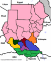
-
 SVG
SVG


- Article(s)
- Equatoria
- Request
- please redraw less chunky, without watermark, and upload to Commons… -- Kintetsubuffalo (talk) 02:46, 10 August 2017 (UTC)
- Graphist opinion(s)
Kintetsubuffalo ![]() Done - Offnfopt(talk) 00:08, 8 September 2017 (UTC)
Done - Offnfopt(talk) 00:08, 8 September 2017 (UTC)
- Wow, much better, and I love your color palette, thank you!--Kintetsubuffalo (talk) 13
- 02, 8 September 2017 (UTC)
Tiny SVG edit
-
 Map of the Lynchburg metropolitan area

- Article(s)
- Lynchburg metropolitan area
- Request
- Could you make Bedford (the western small red blob) part of the surrounding big red blob? It's no longer a separate entity. I tried to remove it in Notepad (look for the text points="401.609,248.279 399.563,247.693 398.561,247.523), but if I delete the whole section where its boundaries are specified, Bedford simply becomes white, rather than disappearing, and since it doesn't have a name, I can't figure out where else it is defined. Nyttend (talk) 00:11, 4 September 2017 (UTC)
- Graphist opinion(s)
Nyttend ![]() Done - Offnfopt(talk) 03:05, 4 September 2017 (UTC)
Done - Offnfopt(talk) 03:05, 4 September 2017 (UTC)
- Thank you. How did you do it? Nyttend (talk) 03:06, 4 September 2017 (UTC)
Nyttend correct. The red area was done by a polygon, but after removing that, a area the same size was cut out of the larger path. If you knew which path it was cut out of and you really wanted to, you could edit it in a text editor. The path looked something like this:
<path fill="#FF0000" stroke="#000000" stroke-miterlimit="10" d="M407.385,214.438l-0.115,0.73l0.255,0.354l0.322,
etc etc etc
,214.438z M401.609,248.279l0.764-3.506l-1.041-1.301l-3.58,0.531l-0.161,0.102l-0.169,0.824l-2.157-0.008l-0.062,0.924l1.725,1.094l-0.062,1.293l0.793,0.216l0.207,0.106l0.692-1.031l1.002,0.17L401.609,248.279z"/>
If you look at the way paths work, they use these values:
- M = moveto
- L = lineto
- H = horizontal lineto
- V = vertical lineto
- C = curveto
- S = smooth curveto
- Q = quadratic Bézier curve
- T = smooth quadratic Bézier curveto
- A = elliptical Arc
- Z = closepath
So it starts out with "M407.385,214.438" i.e. 'move to' 407.385,214.438, then a bunch of 'line to' and eventually you see a 'Z' (close path). You see two sections that start with M and end with Z in that same path. The second section at the end where it starts with M401.609,248.279 (move to), that section is smaller, so logic says that is probably the smaller area of that path. So if you delete where it starts with M401.609,248.279 to the end where it ends with Z (close path), that also removes the smaller section.
Or since that is a bit of a pain you can open it with Inkscape and let it deal with figuring out which numbers belong to which visual elements. It is good to understand what is going on with the mark up so you can fix it when problems occur or if you want to manually optimize a file, or if you're writing a script/application that outputs SVG files, but most the time when it comes comes down to it, it is easier to use a visual editor. I started out writing SVG files in a text editor, as a learning experience, but now I mostly use a visual editor unless doing manual fixing/optimizing. Offnfopt(talk) 05:05, 4 September 2017 (UTC)