
Wells, Kansas
Wells, Kansas | |
|---|---|
 | |
 Wells  Wells | |
| Coordinates: 39°08′21″N 97°33′04″W / 39.13917°N 97.55111°W[1] | |
| Country | United States |
| State | Kansas |
| County | Ottawa |
| Elevation | 1,371 ft (418 m) |
| Population | |
| • Total | 45 |
| Time zone | UTC-6 (CST) |
| • Summer (DST) | UTC-5 (CDT) |
| Area code | 785 |
| FIPS code | 20-76550 |
| GNIS ID | 2804518[1] |
Wells is an unincorporated community in Ottawa County, Kansas, United States.[1] As of the 2020 census, the population of the community and nearby areas was 45.[2]
History[edit]
The first post office in Wells was established in 1888 and was called Poe until 1892. It remained in operation until it closed in 1996.[3]
Demographics[edit]
| Census | Pop. | Note | %± |
|---|---|---|---|
| 2020 | 45 | — | |
| U.S. Decennial Census | |||
For statistical purposes, the United States Census Bureau has defined Wells as a census-designated place (CDP).
Education[edit]
The community is served by North Ottawa County USD 239 public school district.
References[edit]
- ^ a b c d U.S. Geological Survey Geographic Names Information System: Wells, Kansas
- ^ a b "Profile of Wells, Kansas (CDP) in 2020". United States Census Bureau. Archived from the original on December 12, 2021. Retrieved December 12, 2021.
- ^ "Kansas Post Offices, 1828-1961". Kansas Historical Society. Archived from the original on October 9, 2013. Retrieved June 22, 2014.
Further reading[edit]
External links[edit]
Municipalities and communities of Ottawa County, Kansas, United States | ||
|---|---|---|
| Cities | 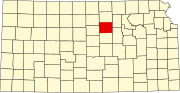 | |
| Unincorporated communities | ||
| Ghost towns | ||
| Footnotes | †This community is designated a Census-Designated Place (CDP) by the United States Census Bureau. | |
This article about a location in Ottawa County, Kansas is a stub. You can help Wikipedia by expanding it. |