
Vijaypur, Uttarakhand
Vijaypur
Bijaypur | |
|---|---|
 | |
 Vijaypur Location in Uttarakhand, India  Vijaypur Vijaypur (India) | |
| Coordinates: 29°50′N 79°55′E / 29.84°N 79.92°E | |
| Country | |
| State | Uttarakhand |
| District | Bageshwar |
| Named for | Vijay Lal Shah |
| Area | |
| • Total | 1 km2 (0.4 sq mi) |
| Elevation | 2,050 m (6,730 ft) |
| Population (2011)[2] | |
| • Total | 89 |
| • Density | 89/km2 (230/sq mi) |
| Languages | |
| • Official | Hindi Sanskrit |
| • Spoken | Kumaoni |
| Time zone | UTC+5:30 (IST) |
| PIN | |
| Telephone code | 059628 |
| Vehicle registration | UK 02 |
| Website | uk |
Vijaypur, officially known as Bijaypur is a hill station and village situated in Bageshwar district in the state of Uttarakhand, India. It is located at a distance of 30 km from Bageshwar and 5 km from Kanda; amidst dense Pine Forests on the Bageshwar-Chaukori Highway.[5][6]
It is situated at an altitude of 2050m, and is known for its panoramic views of snow-capped Himalayan peaks like Trisul, Nanda Devi and Nanda Kot.[1] The Dhaulinag Temple, situated in vijaypur is among the 8 prominent Nag temples of Kumaun, the others being Berinag, Kalinag, Feninag, Karkotaknag, Pinglenag, Kharharinag and Athgulinag.
Places of interest[edit]

Dhaulinag temple[edit]
Dhaulinag temple is situated at the top of the Vijaypur Mountain.[7] The temple is located at walking distance from Vijaypur, and is visited by devotees mainly during Navratri. Panchmi Mela is a very famous festival celebrated over here.[8][9]
Tea gardens[edit]
The tea estate at Vijaypur was set up by the British in the twentieth Century.[10] Much later, the estate was acquired by Vijay Lal Shah, a Gujarati trader, who self-importantly renamed the town after himself.
Transport[edit]
Vijaypur is located on the NH 309A at a distance of 30 km from Bageshwar[11] and 5 km from Kanda. Share-Taxis are available from Vijaypur towards the nearby towns of Kanda, Kotmunya and Udiyari bend. Buses run by Uttarakhand Transport Corporation and K.M.O.U connect it to cities of Bageshwar, Almora, Berinag and Delhi. It lies on the route of Kailash Mansarovar.[12]
Gallery[edit]
-
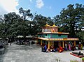 Dhaulinag Temple
 -
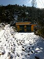 Vijaypur after Snowfall
 -
 Tea Gardens, Vijaypur
 -
 Milestone on NH 309A at Vijaypur
 -
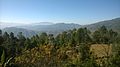 View from Vijaypur


See also[edit]
References[edit]
- ^ a b Goyal, Ashutosh (May 2014). RBS Visitors Guide INDIA - Uttarakhand: Uttarakhand Travel Guide. Data and Expo India Pvt. Ltd. ISBN 9789380844794.
- ^ Bijaypur Population - Bageshwar, Uttarakhand
- ^ "Pin Code of Vijaypur in Uttarakhand". www.mapsofindia.com. Retrieved 13 May 2017.
- ^ "Pin Code: VIJAIPUR, BAGESHWAR, UTTARAKHAND, India, Pincode.net.in". pincode.net.in. Retrieved 13 May 2017.
- ^ Budhwar, Prem K. (2010). The call of the mountains : Uttrakhand explored. New Delhi: Har-Anand Publications. p. 90. ISBN 9788124115299. Retrieved 13 May 2017.
- ^ "Vijaypur | Uttarakhand". ukuttarakhand.com. Retrieved 13 May 2017.
- ^ "महिलाओं ने निकाली कलशयात्रा" (in Hindi). Bageshwar: Amar Ujala. 23 April 2015. Retrieved 13 May 2017.
- ^ "Dhauli Nag Temple in Bageshwar, Uttarakhand". www.discoveredindia.com. Retrieved 13 May 2017.
- ^ Śarmā, Devīdatta (1983). Linguistic history of Uttarākhaṇḍa. Vishveshvaranand Vedic Research Institute.
- ^ Sati, Vishwambhar Prasad (2014). Towards Sustainable Livelihoods and Ecosystems in Mountain Regions. Cham: Springer. ISBN 9783319035338. Retrieved 13 May 2017.
- ^ Maiṭhāṇī, Vācaspati (2004). Gaṛhavāla Himālaya kī deva saṃskr̥ti: eka sāmājika adhyayana (in Hindi). Gāndhī Hindustānī Sāhitya Sabhā. ISBN 9788186198223. Retrieved 13 May 2017.
- ^ Chamaria, Pradeep (1996). Kailash Manasarovar on the Rugged Road to Revelation. New Delhi: Abhinav Publications. ISBN 9788170173366. Retrieved 13 May 2017.