
User talk:Oganesson007
Error in US map.[edit]
Could you fix United States Koppen climate map: https://commons.m.wikimedia.org/wiki/File:USA_map_of_K%C3%B6ppen_climate_classification.svg? It has nonexestent Cfa climates in California.
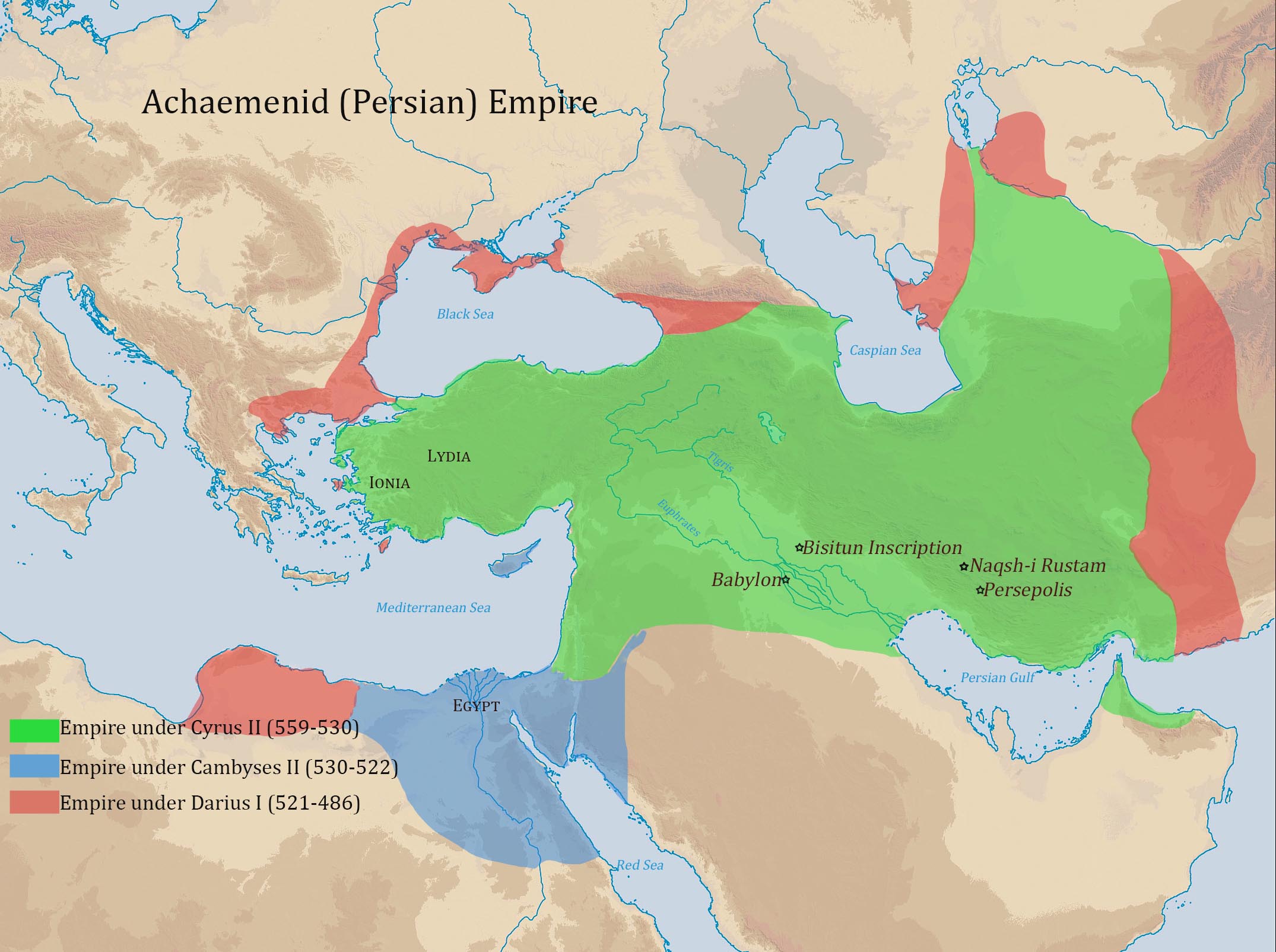
Regarding your new Achaemenid map.[edit]
Hello Ali Zifan,
I already left a new comment on the talk page of the Achaemenid Empire. The new map looks sweet, just I am completely convinced that while its reliable and sources, its 70+ years old. Darius and Xerxes conquered much larger territories in Europe, as we know. All of Paeonia, Thrace, Macedon, most of the Black Sea coasts, all of Greece to the north of the Isthmus of Corinth, were added by Darius I and Xerxes I. I can give you the needed sources to re-add these territories so you can add the sources to the source description on Wikimedia. Ok? Basically the territories in Europe should show like on these maps [1] - [2]. If you could fix that for now, that would be great. Bests - LouisAragon (talk) 12:58, 18 October 2015 (UTC)
![[1]](https://upload.wikimedia.org/wikipedia/commons/archive/1/19/20151014003618%21Achemenids500BC.png)
- Btw, if you have some spare time, could you fix this map as well? Some hoaxer added Iranian Balochistan to the Mauryan Empire, which is total nonsense and no historian has ever agreed upon an extent beyond Pakistani Balochistan. Thus, the map must include Iranian balochistan to the Seleucid territories. Could you do that if you happen to have some spare time? You're much better with editing maps than me, namely ;-) Tashakor mikonam wasse hamme karrat. Haha. Khoda hafez ;-) - LouisAragon (talk) 13:28, 18 October 2015 (UTC)
- I have time to make its vector and fix it as I've already made it's orthographic projection. If it is possible, please put the links of some historical maps about Seleucid territories so I can make it as precise as it is possible, especially for the territories in the east part including Baluchistan (as you mentioned). Thank you! Ali Zifan 20:27, 20 October 2015 (UTC)
- Salam Ali, I can give you several top-notch sources that confirm that rule never extended to include Iranian Balochistan. Can you use those for now while I find a map? Bests - LouisAragon (talk) 18:16, 22 October 2015 (UTC)
- Hello LouisAragon. I uploaded a new vector map of Selecuid Empire map based on three sources. I tried to make the best combination and make it is as precise as I could. Ali Zifan 02:31, 25 October 2015 (UTC)
.svg)
- Hey @Ali Zifan:, Wikimedia maps are not sources and should not be used as sources. Your map contains many fallacies therefore (Even though it was obviously not your intention). Atropatene, large parts of Anatolia, etc were never part of the Seleucids. The previous map was entirely correct, except for Iranian Balochistan, which was part of the Seleucids, and not the Mauryas. If you could model this new vector map you made PRECISELY after this previous map, but just could add Iranian Balochistan to it, then it would be perfect. Could you also please fix [3] at the same time as well? It just needs Iranian Balochistan to be part of the Seleucids, thats all. Im just basically asking you this favour as we don't want a factually wrong map to linger forth on Wikimedia. - LouisAragon (talk) 21:59, 25 October 2015 (UTC)
- The map that I've uploaded before may had some problems, because I tried to make a combination from different sources. Now, I updated the map based on reliable source (Willamette University). This map may look correct to you but it doesn't have any sources so that is why I didn't make the new map exactly based on that unsourced map. Ali Zifan 22:46, 29 October 2015 (UTC)
- Btw, the current Achaemenid Empire map; after which map is it currently modeled? Could you tell me that? :) After the one you linked above in reply to my previous comment, aka an already existing Wikimedia map, or this one? The latter which UCaetano also agreed upon? It should be modeled upon this map I'm linking right here. Btw, don't forget to add Macedon to the map ;-). Khoda hafez - LouisAragon (talk) 00:52, 23 October 2015 (UTC)
- Hey @Ali Zifan:, Wikimedia maps are not sources and should not be used as sources. Your map contains many fallacies therefore (Even though it was obviously not your intention). Atropatene, large parts of Anatolia, etc were never part of the Seleucids. The previous map was entirely correct, except for Iranian Balochistan, which was part of the Seleucids, and not the Mauryas. If you could model this new vector map you made PRECISELY after this previous map, but just could add Iranian Balochistan to it, then it would be perfect. Could you also please fix [3] at the same time as well? It just needs Iranian Balochistan to be part of the Seleucids, thats all. Im just basically asking you this favour as we don't want a factually wrong map to linger forth on Wikimedia. - LouisAragon (talk) 21:59, 25 October 2015 (UTC)
.svg)
- It mostly is based on this one but I actually considered this too. UCaetano is totally agree with the this source; actually he suggested it. I also updated the map based on History of Persia's request about Egypt and Maka too.
.svg)
- Yes modeling it after that map which we ageed upon, aka this one is the best indeed, but you can obviously combine it with that older Academic map too. Only Macedon needed to be added to it, but for the rest, its totally perfect! Btw, mate, History of Persia is a long-term vandal and blocked hoaxer and sockpuppet whos indeffed. So it would be a good thing to revert those last changes back, at least anything he requested! ;-) - LouisAragon (talk) 21:59, 25 October 2015 (UTC)
- Further, I uploaded a version of Achaemenid map under different kings conquests based on this source this and this too.Ali Zifan 02:31, 25 October 2015 (UTC)
.svg)
- Good, good, that's great! - LouisAragon (talk) 21:59, 25 October 2015 (UTC)
- PS: sorry I'm asking you several things now, excuse me for that, but could you perhaps if you happen to have some time to update this map? The colour for Iran needs to be one shade darker, just like the one Georgia has. Tashakor mikonam yebar digeh, Ali. - LouisAragon (talk) 01:04, 23 October 2015 (UTC)
- You're fine!😸 I updated that map. Ali Zifan 02:31, 25 October 2015 (UTC)
- Also, this great map you created needs to have its borders in Anatolia and the Caucasus corrected per this reference map which is used. I know you intended to model it 100% after that map, but there are some minor adjustments that need to be made as you can see, if you look closely. F.e the largest extent in Anatolia comprised a bigger territory as you can see. Tashakor mikonam yebar digeh ;-) - LouisAragon (talk) 15:27, 24 October 2015 (UTC)
- PS: sorry I'm asking you several things now, excuse me for that, but could you perhaps if you happen to have some time to update this map? The colour for Iran needs to be one shade darker, just like the one Georgia has. Tashakor mikonam yebar digeh, Ali. - LouisAragon (talk) 01:04, 23 October 2015 (UTC)
.svg)
 Fixed. I really didn't see any problem on Caucasus part, but totally I updated it.Ali Zifan 02:31, 25 October 2015 (UTC)
- Tashakor mikonam! Bests - LouisAragon (talk) 21:59, 25 October 2015 (UTC)
- Btw, @Ali Zifan:, you can add this sourcing[1] for the inclusion of Macedon to all the Achaemenid maps as I requested above. Bests - LouisAragon (talk) 22:07, 25 October 2015 (UTC)
- @LouisAragon: I will. Thank you for giving the source. Ali Zifan 18:31, 29 October 2015 (UTC)
- Btw, @Ali Zifan:, you can add this sourcing[1] for the inclusion of Macedon to all the Achaemenid maps as I requested above. Bests - LouisAragon (talk) 22:07, 25 October 2015 (UTC)
Do you have an email address?[edit]
Salam Ali Zifan,
How are you doing? Chetori? :) I would like to thank you very much once again for your edits on those maps! I genuinely appreciate it, great work. I wondered, do you perhaps have an email adres? I would like to ask some things if you don't mind, and perhaps we can work together even easier from there.
- Hello and your welcome! My email address is :alizf.wiki@gmail.com. Ali Zifan 03:59, 8 November 2015 (UTC)
Btw, looking at this map - this, and this, do you think you can fix some area's, if I would tell you what? I have some references already set, but I can easily get the rest that are needed. Its all very simple and not time-consuming work (not much needs to be changed), just we need someone who's good with editing pictures, The user who created it (thumbs to him) created decent, more modern maps, but then disappeared from Wiki. The map aint finished yet at all, but he already just spammed them everywhere before leaving.. :/ Could you let me know the answers on both of these questions and if you want to correct this together with me? I will delete your email as soon as I have read it.
- Yes. You may message me on my email or talk page if you want. Ali Zifan 04:02, 8 November 2015 (UTC)
PS: you greatly updated the Achaemenid map ! Did you base the addition of the territory of Macedon upon this one perhaps? Dont worry, your new drawing to add Macedon was totally correct and well sourced, but I just wanted to know for myself, that's all. Also, this map needs to have its borders corrected per the borders here, on your fully fixed map. Also, there are some corrections to be made on the territories in the Caucasus, and Black Sea regions of Georgia, Abkhazia, Ukraine etc, as you can see on our reference map. Khoda hafez for now, my friend :-) (and sorry for asking much from you) - LouisAragon (talk) 01:35, 3 November 2015 (UTC)
.svg)
.svg)
- I will fix those. Thank you for the notice.Ali Zifan 04:05, 8 November 2015 (UTC)
 |
An image created by you has been promoted to featured picture status Your image, File:Prokaryote cell.svg, was nominated on Wikipedia:Featured picture candidates, gained a consensus of support, and has been promoted. If you would like to nominate an image, please do so at Wikipedia:Featured picture candidates. Thank you for your contribution! Armbrust The Homunculus 13:02, 5 November 2015 (UTC)
|
Could you fix this map?[edit]
Hey @Ali Zifan:, could you fix this map accordingly so that it comprises all the territory of what is nowadays Azerbaijan Republic as well as all of Eastern Georgia? Just the entire eastern part of Georgia if you would split the nation in twice. Could you do that? It was partly fixed by user HistoryofIran over a year ago, but he omitted these regions due to a lack of time. Just needs a minor extra drawing of territory. Thank you! PS: I only read your reply to my last messages right now, you can expect my email pretty soon! :-) - LouisAragon (talk) 02:23, 23 November 2015 (UTC)
- Hello. I will fix that as soon as I can. Thank you! Ali Zifan 16:00, 24 November 2015 (UTC)
- @Ali Zifan:, ok, thanks a lot! It's a much needed fix the map needs. Btw, excuse me I haven't mailed yet, been very busy, and I don't want to form some half-written email without proper stuff. Anyways, expect it coming in due time. ;-) Btw. You added a name climate map to the Iran article, but I believe you erroneously removed one legend subsection. I re-added it, just in case. Btw I wonder, the Caspian Region of Iran has the same Koppen classification like the rest of Iran? Its stated like that on the map namely. Sounds like nonsense to me! - LouisAragon (talk) 22:54, 29 November 2015 (UTC)
- Hello. I actually made that map exactly based on the Köppen climate classification(world map) and the Caspian region was the same as the rest part.Ali Zifan 01:18, 30 November 2015 (UTC)
- @Ali Zifan:, ok, thanks a lot! It's a much needed fix the map needs. Btw, excuse me I haven't mailed yet, been very busy, and I don't want to form some half-written email without proper stuff. Anyways, expect it coming in due time. ;-) Btw. You added a name climate map to the Iran article, but I believe you erroneously removed one legend subsection. I re-added it, just in case. Btw I wonder, the Caspian Region of Iran has the same Koppen classification like the rest of Iran? Its stated like that on the map namely. Sounds like nonsense to me! - LouisAragon (talk) 22:54, 29 November 2015 (UTC)
- Well, it looks odd to me. Doesnt it to you? So central Iran has the same climate as Caspian Iran?... Haha - LouisAragon (talk) 13:53, 12 December 2015 (UTC)
A barnstar for you![edit]

|
The Original Barnstar |
| For your good work and always kind and positive attitude. Maybe the majority lets it go unnoticed, but I won't. Thank you. Bests LouisAragon (talk) 02:25, 23 November 2015 (UTC) |
Thanks! Ali Zifan
Hi,
You appear to be eligible to vote in the current Arbitration Committee election. The Arbitration Committee is the panel of editors responsible for conducting the Wikipedia arbitration process. It has the authority to enact binding solutions for disputes between editors, primarily related to serious behavioural issues that the community has been unable to resolve. This includes the ability to impose site bans, topic bans, editing restrictions, and other measures needed to maintain our editing environment. The arbitration policy describes the Committee's roles and responsibilities in greater detail. If you wish to participate, you are welcome to review the candidates' statements and submit your choices on the voting page. For the Election committee, MediaWiki message delivery (talk) 17:03, 24 November 2015 (UTC)
Mail[edit]
I sent you the email! :-) - LouisAragon (talk) 14:45, 17 February 2016 (UTC)
 Checked Ali Zifan 08:34, 21 February 2016 (UTC)
Edit .SVG maps[edit]
Salam Mr. Zifan Thank you for your maps, it's a great project editing through SVG, I am new to WikiMedia, started in the maps field and really want to learn the modern ways to use them, can you please post a guide on a better way to edit maps easier, or provide the software that you use to make editing the vectors easier, thanks. — Preceding unsigned comment added by YemArabSf (talk • contribs) 17:19, 22 February 2016 (UTC)
- If I got time I will post and start new pages. If not, I will send you some helpful links! Ali Zifan 22:46, 25 February 2016 (UTC)
Hey Ali Zifan, I'd be interested in this, too. Besides that, how do I get programs which are able to edit .svg-files? With Gimp, I can open and edit them but I can't save them as .svg-file. Also I'd like to help improving the Templates for these maps. I found out that this is to be done over the Modules. But how can I get the exact coordinates of a location, town etc.? And of course I want to thank you for your great work here, it's really great!--Ermanarich (talk) 18:37, 19 March 2016 (UTC)
- Hello Ermanarich. Thanks for the feedback. I mostly use Adobe Illustrator and Inkscape to create and edit SVG files. Inkscape is a free software and you can download it from here. For making the map based on module, you can get the coordinate of the points (cities) base on Module documentation and transfer the coordinates into a software or redraw some parts like I did with some of the maps based on different sources. Ali Zifan 22:32, 19 March 2016 (UTC)
Needed a bit to figure it out, but the .svg-thing works now. Thank you very much! Only with the Module/Template-thing I still have a problem. I actually meant how I can add new points/cities/etc. The coordinates of existing ones are already in the module, but how can I add a new point at a correct place? And what did you mean with this: "[...] redraw some parts like I did with some of the maps based on different sources"? Again thank you for the fast help!--Ermanarich (talk) 19:56, 20 March 2016 (UTC)
Hey, it's me again. I'm now quite active in updating some of the maps of civil wars you created. There is only one problem: Which font style did you use to write the town's names and is this font style available on Inkscape? Thanks in advance, --Ermanarich (talk) 11:15, 22 April 2016 (UTC)
- @Ermanarich: Hi. It is Arial Regular; But remember to "create outline" after saving a file because the fonts may appear differently on preview. Also thank you for your great contributions. Ali Zifan 02:28, 1 May 2016 (UTC)
A barnstar for you![edit]

|
The Graphic Designer's Barnstar |
| It has no more than two days you did your maps, but I have found them, and I am very grateful to you for this contribution. Excluding Syrian, Libyan and Afghan war (which by the way had no map, even if it is a location that has the attention of the news), all other wars are unknown to the common public. With your work, we have something to start. A simple Wikipedian ([[User talk:Um simples
Wikipedista|said]] and did) 18:42, 23 February 2016 (UTC) |
Thank you! :) Ali Zifan 22:44, 25 February 2016 (UTC)
Mexican Drug war map[edit]
Hey Zifan, thanks for you recent war oi Somalia and in Afghanistan. Can you create a map of Mexican drug war? If you cannot no problem. Send my a ,message for your answer, and thanks for reading.--Tiseptiko (talk) 9:30, 25 February 2016 (UTC) -- I've answered on your talk page. Ali Zifan 22:44, 25 February 2016 (UTC)
Midi[edit]
Hey again Zifan, thanks for your accept for Mexican drug war. Can you update the Yemen war map? Only the Midi district, that captured by Hadi loyalists a month ago, because the map sowing it contested. Thanks for reading.--Tiseptiko (talk) 5:58, 26 February 2016 (UTC)
 Done Ali Zifan 02:03, 29 February 2016 (UTC)
Yemen map[edit]
Hey Ali, sorry bothering you again, but how i can upload a new version on Yemen war map? Wen i download the map and do my edits in my pc, the Wikipedia does not let my upload it because o some SVG think(File extension ".svg" does not match the detected MIME type of the file (image/png).)? can you explain my what to do? thanks for reading.Tiseptiko (talk) 21:58, 29 February 2016 (UTC)
- Hi. Do you have any softwares (like Adobe Illustrator or Inskcape) for editing SVG images? That problem happened because the format that you upload is not SVG. Please message me if you have questions. Ali Zifan 23:08, 29 February 2016 (UTC)
Africa[edit]
hello: I have just seen your edit on Mozambique and am wondering how you became interested in Africa. --Aflis (talk) 16:52, 26 February 2016 (UTC)
Argentina Climate[edit]
Thanks for adding in the Köppen climate classification map on the Climate of Argentina article. It was something that was really needed on the article. Ssbbplayer (talk) 17:10, 4 March 2016 (UTC)
- You're welcome! Ali Zifan 23:29, 5 March 2016 (UTC)
Taliban (TTIP) presence coordinates for Pakistani conflicts and wars module[edit]
Hello. I recently created the map "Pakistani conflicts and wars detailed map". In your file File:War in North-West Pakistan.svg, i cannot insert your file's Taliban presences to my map because i can't get the coordinates. Can you help me add these presences to this module? That would be helpful. --SMB99thx XD (contribs) 08:53, 11 March 2016 (UTC)
Mail :-)[edit]

It may take a few minutes from the time the email is sent for it to show up in your inbox. You can at any time by removing the {{You've got mail}} or {{ygm}} template.
- LouisAragon (talk) 03:31, 20 March 2016 (UTC)
- Checked Ali Zifan 02:14, 24 March 2016 (UTC)
New York State Climate Map[edit]
Hey there! You have done excellent work on illustrating New York's climate regions. One minor problem with your map is that New York City actually has a humid subtropical climate (using both the 0 C and -3 C thresholds) so it should be shaded in the color for humid subtropical climate. Still, your work on not only this page but on a number of pages is greatly appreciated. G. Capo (talk) 03:41, 27 March 2016 (UTC)
Re:Map update[edit]
Well done! - Alumnum (talk) 04:24, 10 May 2016 (UTC)
Paramecium diagram[edit]
Your image was quite nice-looking, but I had to remove it from the Paramecium page because it was not accurate. You put the anal pore at the anterior pole of the cell, ahead of the oral groove. It belongs in the posterior quarter of the cell (the narrower end, which in this image is at the top of the drawing). It should be on the same side of the cell as the oral groove, and just a bit behind it. Deuterostome(talk) 12:20, 14 June 2016 (UTC)
- Thank you for the notice.Ali Zifan 01:55, 22 June 2016 (UTC)
US Koeppen climate maps[edit]
Hello, I’ve made versions of my Koeppen climate maps in the preferred SVG format and added them to their respective state wiki pages. If you had any concerns about the maps beyond their not being in SVG format, and wish to revert then back to yours, I was hoping we could discuss it here. Thanks! Redtitan (talk) 21:00, 9 August 2016 (UTC)
- Every File with ".svg" extention doesn't mean it is really vector. Please read this if you want. If you zoom in the climate maps that you've upload, pixels in climate regions are still visible. Although with that, I am Ok and with your files since ,at least, the texts are in vector and I appreciate the works. Ali 02:52, 10 August 2016 (UTC)
- Thanks for the reply. I noticed you're changing the author credits of the maps to Oregon State University. I calculated the Koeppen types using raw climate data from Oregon State University (mean temperatures, max/min temperatures, precipitation), but they were not involved in the steps of map creation in any way (symbolizing, text, object placement, data clipping, Koeppen type calculation, etc.). I properly credit them as a data source. There are many examples of other maps on wikimedia commons that are made sourcing outside data, while the author remains the creator, your maps included. I'll be reverting the author credits back to myself. Redtitan (talk) 04:09, 10 August 2016 (UTC)
Najran conglict map[edit]
Hi

could you create a svg map and update it about Najran ? Regards. --Panam2014 (talk) 23:51, 23 August 2016 (UTC)
Qajar orthographic map+language map[edit]
Hey Ali,
Could you perhaps correct this map so that it shows the borders per the main Qajar map we use? The non-RS source applied to the file is simply mentioning bogus borders. Thanks much in advance! - LouisAragon (talk) 01:28, 11 October 2016 (UTC)
.svg)
- Oh, and I just recalled this matter as well. Some time ago, I asked whether you could fix this language map. Do you vaguely recall that? You correctly told back then, that you couldn't change the map as it was protected. You are better versed with the rules of pics and stuff, so I wondered; would it be possible for us if we'd upload a new version of the map under a different name? By that we could still "fix the map", if you get what I mean. If yes, please let me know. I still should have the sources for those needed fixes laying somewhere in my files.
- Lastly! Is there anything else that I can help you with, such as, providing sources for other maps you want to create/or have created? Please don't hesitate to let me know! - LouisAragon (talk) 01:28, 11 October 2016 (UTC)
- Hello @LouisAragon:. Thank you for the message. I will fix and upload them as soon as I can. Bests.Ali 12:53, 21 October 2016 (UTC)
Update for image of tallest hotels in the world[edit]
There is an image in List of tallest hotels page about photographic comparing the tallest hotels. It seems that you have made it. In this image the first tallest one is missing. Would you please fix it? Messi (talk) 21:17, 16 October 2016 (UTC)
- I'll update as soon as I can. Ali 12:50, 21 October 2016 (UTC)
Merger discussion for List of Iranian cities and towns by province[edit]

An article that you have been involved in editing—List of Iranian cities and towns by province—has been proposed for merging with another article. If you are interested, please participate in the merger discussion. Thank you. Yilangren (talk) 03:26, 16 November 2016 (UTC)
ArbCom Elections 2016: Voting now open![edit]
Hello, Ali Zifan. Voting in the 2016 Arbitration Committee elections is open from Monday, 00:00, 21 November through Sunday, 23:59, 4 December to all unblocked users who have registered an account before Wednesday, 00:00, 28 October 2016 and have made at least 150 mainspace edits before Sunday, 00:00, 1 November 2016.
The Arbitration Committee is the panel of editors responsible for conducting the Wikipedia arbitration process. It has the authority to impose binding solutions to disputes between editors, primarily for serious conduct disputes the community has been unable to resolve. This includes the authority to impose site bans, topic bans, editing restrictions, and other measures needed to maintain our editing environment. The arbitration policy describes the Committee's roles and responsibilities in greater detail.
If you wish to participate in the 2016 election, please review the candidates' statements and submit your choices on the voting page. MediaWiki message delivery (talk) 22:08, 21 November 2016 (UTC)
US Presidential Timeline work[edit]
Hi, I saw your name on Wikipedia:WikiProject U.S. Presidents/Active participants. The newly created presidential timelines on Template:US Presidential Administrations need work! They're pretty easy to work on! I can't do them alone! The timelines provide great reading material for many Wikipedia readers. All your contributions are greatly appreciated. Ethanbas (talk) 06:53, 19 February 2017 (UTC)
Mail[edit]
It may take a few minutes from the time the email is sent for it to show up in your inbox. You can at any time by removing the {{You've got mail}} or {{ygm}} template.
- LouisAragon (talk) 02:03, 22 July 2017 (UTC)
از دوستی قدیمی[edit]
سلام علی جان. مدتی پیش پیامی در ویکیفا در صفحهٔ بحثت برایت گذاشتهبودم. دیدم بیپاسخ مانده. دیگر آنجا فعال نیستی؟--Arfarshchi (talk) 12:00, 24 July 2017 (UTC)
- با سلام بر شما. این مدت کمی مشغول بودم و خیلی نمیتوانستم ویرایش کنم. نقشه ی انتخاباتی که درباره ی رای های آقای روحانی بود را نیز اگر وقت کردم در آینده تهیه میکنم. Og007 02:18, 30 July 2017 (UTC)
Replied[edit]
Just in case you missed it; left a reply : -) - LouisAragon (talk) 14:43, 3 September 2017 (UTC)
ArbCom 2017 election voter message[edit]
Hello, Oganesson007. Voting in the 2017 Arbitration Committee elections is now open until 23.59 on Sunday, 10 December. All users who registered an account before Saturday, 28 October 2017, made at least 150 mainspace edits before Wednesday, 1 November 2017 and are not currently blocked are eligible to vote. Users with alternate accounts may only vote once.
The Arbitration Committee is the panel of editors responsible for conducting the Wikipedia arbitration process. It has the authority to impose binding solutions to disputes between editors, primarily for serious conduct disputes the community has been unable to resolve. This includes the authority to impose site bans, topic bans, editing restrictions, and other measures needed to maintain our editing environment. The arbitration policy describes the Committee's roles and responsibilities in greater detail.
If you wish to participate in the 2017 election, please review the candidates and submit your choices on the voting page. MediaWiki message delivery (talk) 18:42, 3 December 2017 (UTC)
Source GIS files?[edit]
Hello Ali! First, a deep and sincere thank you for all the wonderful map work you've create for the Wikimedia Community. I'm very interested in historical mapping and using GIS-based vector information to build programmable maps... kind of like Google Maps or OpenStreetMap. Do you have any GIS or georeferenced versions of your various svg maps? I've just created some of these source data files for the Persian Empire in 1850 (just a coincidence!), based on the Mitchell 1850 Map. If you had similar GIS data for your various Persian empire maps & other historical maps, that would be fantastic. Thanks!! --Jeffme (talk) 03:06, 23 February 2018 (UTC)
ArbCom 2018 election voter message[edit]
Hello, Oganesson007. Voting in the 2018 Arbitration Committee elections is now open until 23.59 on Sunday, 3 December. All users who registered an account before Sunday, 28 October 2018, made at least 150 mainspace edits before Thursday, 1 November 2018 and are not currently blocked are eligible to vote. Users with alternate accounts may only vote once.
The Arbitration Committee is the panel of editors responsible for conducting the Wikipedia arbitration process. It has the authority to impose binding solutions to disputes between editors, primarily for serious conduct disputes the community has been unable to resolve. This includes the authority to impose site bans, topic bans, editing restrictions, and other measures needed to maintain our editing environment. The arbitration policy describes the Committee's roles and responsibilities in greater detail.
If you wish to participate in the 2018 election, please review the candidates and submit your choices on the voting page. MediaWiki message delivery (talk) 18:42, 19 November 2018 (UTC)
ArbCom 2019 election voter message[edit]
ArbCom 2021 Elections voter message[edit]
ArbCom 2023 Elections voter message[edit]
Hello! Voting in the 2023 Arbitration Committee elections is now open until 23:59 (UTC) on Monday, 11 December 2023. All eligible users are allowed to vote. Users with alternate accounts may only vote once.
The Arbitration Committee is the panel of editors responsible for conducting the Wikipedia arbitration process. It has the authority to impose binding solutions to disputes between editors, primarily for serious conduct disputes the community has been unable to resolve. This includes the authority to impose site bans, topic bans, editing restrictions, and other measures needed to maintain our editing environment. The arbitration policy describes the Committee's roles and responsibilities in greater detail.
If you wish to participate in the 2023 election, please review the candidates and submit your choices on the voting page. If you no longer wish to receive these messages, you may add {{NoACEMM}} to your user talk page. MediaWiki message delivery (talk) 00:43, 28 November 2023 (UTC)
- ^ Joseph Roisman,Ian Worthington. "A companion to Ancient Macedonia" John Wiley & Sons, 2011. ISBN 978-1444351637 pp 135-138, pp 343-345