
User talk:Fredddie/Archives/2010
| This is an archive of past discussions. Do not edit the contents of this page. If you wish to start a new discussion or revive an old one, please do so on the current talk page. |
Rollback
As requested, I have added rollback to your account. Ensure you only use rollback correctly, ie its intended usage of reverting vandalism only. For information on rollback see: Wikipedia:New admin school/Rollback and Wikipedia:Rollback feature. Cheers, NJA (t/c) 11:15, 4 January 2010 (UTC)
Reply
I have replied to your message left on my talk page, and copied the conversation to Talk:List_of_state_routes_in_Arizona. Shereth 22:18, 4 January 2010 (UTC)
Why
[1] What is your intent? This is breaking stuff left and right.Dave (talk) 00:11, 7 January 2010 (UTC)
Speedy deletion nomination of Template:Shban/sandbox

Thank you for experimenting with Wikipedia. Your test worked, and the page that you created has been or soon will be deleted. Please use the sandbox for any other tests you want to do. Take a look at the welcome page if you would like to learn more about contributing to our encyclopedia. You may also wish to consider using a Wizard to help you create articles - see the Article Wizard.
If you think that this notice was placed here in error, you may contest the deletion by adding {{hangon}} to the top of the page that has been nominated for deletion (just below the existing speedy deletion or "db" tag), coupled with adding a note on the talk page explaining your position, but be aware that once tagged for speedy deletion, if the page meets the criterion, it may be deleted without delay. Please do not remove the speedy deletion tag yourself, but don't hesitate to add information to the page that would render it more in conformance with Wikipedia's policies and guidelines. Lastly, please note that if the page does get deleted, you can contact one of these admins to request that they userfy the page or have a copy emailed to you. JokerXtreme (talk) 17:42, 4 March 2010 (UTC)
- Delete away! I supported the TfD for {{Shban}} and helped develop its replacement, so I have no objections. --Fredddie™ 21:20, 4 March 2010 (UTC)
Thank you
Thanks a lot for helping me with the banners for the Delaware route list. ---Dough4872 16:42, 15 March 2010 (UTC)
tb

You can remove this notice at any time by removing the {{Talkback}} or {{Tb}} template.
Join the WP:USRDCUP 2010!
We're going to go ahead and try this again! The contest will begin April 1. It is a contest to encourage editors to improve teh quality of WP:USRD articles and participate in USRD. Precautions will be taken to make sure that people do not "game the system" and bring article quality down. Please sign up ASAP! Announcements regarding the contest will be made at WP:USRDCUP, Twitter, and/or IRC. --Rschen7754 06:51, 28 March 2010 (UTC)
Map
Can you just make a few maps for me, lol. It's a lot easier on me then trying to figure out that program. CTJF83 chat 18:06, 28 March 2010 (UTC)
- Heh, sure. I wasn't kidding when I said there was a learning curve. What locations do you need? --Fredddie™ 18:29, 28 March 2010 (UTC)
- Just a few historic neighborhoods [2] for starters. CTJF83 chat 18:30, 28 March 2010 (UTC)
- Are you looking for something like the county location maps, where the map is white and the only thing with color is the neighborhood? --Fredddie™ 18:43, 28 March 2010 (UTC)
- I was thinking
just "copying" the map how it is, or,if you could make a map of Davenport similar to left map, I think pointing a neighborhood out on the Scott County map wouldn't help much. CTJF83 chat 18:47, 28 March 2010 (UTC) - Actually I like your idea better, my map link doesn't really tell people where it is in the city. CTJF83 chat 18:54, 28 March 2010 (UTC)
- I was thinking
- Are you looking for something like the county location maps, where the map is white and the only thing with color is the neighborhood? --Fredddie™ 18:43, 28 March 2010 (UTC)
- Just a few historic neighborhoods [2] for starters. CTJF83 chat 18:30, 28 March 2010 (UTC)
[3], [4], [5], [6], and [7] those are good for now, until I create more articles, thanks, CTJF83 chat 19:31, 3 April 2010 (UTC)
- Would you be able to add some streets to the neighborhood maps you created? :) CTJF83 chat 22:46, 12 April 2010 (UTC)
- I'll have to remake the maps, but that shouldn't be too hard. —Fredddie™ 00:14, 13 April 2010 (UTC)
- LOL, I kind of feel like a pain in the ass....if you do remake can you put in some streets for references, maybe 3 north/south and 3 east/west streets, and then streets surrounding the neighborhoods? CTJF83 chat 17:02, 13 April 2010 (UTC)
- Just to update you, I worked on them today, but I wasn't happy with the results. I think I made them too big (the output was 1000px square). Usually, when I make a map for WP:USRD, I make it small (290x172px) and then enlarge (800x523px) it in Inkscape and the lines look great . This time I started large and the lines were very faint. I saved everything together so it'll be quite easy to output the maps smaller. —Fredddie™ 22:35, 14 April 2010 (UTC)
- OK, I remade them starting at 500x500px and they turned out great. I have uploaded the new versions so they are live commons:User:Fredddie/gallery. With the areas so small relative to the size of the map, I did not add any street names. Just by adding the streets and highways themselves, it makes a huge difference. —Fredddie™ 18:23, 16 April 2010 (UTC)
- Just to update you, I worked on them today, but I wasn't happy with the results. I think I made them too big (the output was 1000px square). Usually, when I make a map for WP:USRD, I make it small (290x172px) and then enlarge (800x523px) it in Inkscape and the lines look great . This time I started large and the lines were very faint. I saved everything together so it'll be quite easy to output the maps smaller. —Fredddie™ 22:35, 14 April 2010 (UTC)
- LOL, I kind of feel like a pain in the ass....if you do remake can you put in some streets for references, maybe 3 north/south and 3 east/west streets, and then streets surrounding the neighborhoods? CTJF83 chat 17:02, 13 April 2010 (UTC)
- I'll have to remake the maps, but that shouldn't be too hard. —Fredddie™ 00:14, 13 April 2010 (UTC)
Your GA nomination of Interstate 235 (Iowa)
The article Interstate 235 (Iowa) you nominated as a good article has passed ![]() ; see Talk:Interstate 235 (Iowa) for eventual comments about the article. Well done! –Grondemar 20:34, 5 April 2010 (UTC)
; see Talk:Interstate 235 (Iowa) for eventual comments about the article. Well done! –Grondemar 20:34, 5 April 2010 (UTC)
BS

|
The Original Barnstar | |
| I'm awarding you this barnstar for all your hard work to make maps for me. Thank you very much for all your help!! CTJF83 chat 18:34, 16 April 2010 (UTC) |
Ohio SR 872
No worries, Fredddie. I thought I had seen your name on the list of who checked of the reviews for the WP:USRDCUP for Sunday. I think that was Mitchazenia, now that I look at it. Thanks for the review on SR 761. Have a great Tuesday! DanTheMan474 (talk) 03:33, 20 April 2010 (UTC)
Just a question
When I tried to enter the IRC channel for the first time, my browser did not let me. Apparently, I need a special program. Is there a special computer requirement to enter and if so, what is it? --PCB 01:43, 28 April 2010 (UTC)
- Check out WP:HWY/IRC —Fredddie™ 01:46, 28 April 2010 (UTC)
Can you update the template to allow a special location. I'd like to replicate the river crossing from this version of the MN-610 article. I think it would be a nice feature for bridges to have as an option. If it weren't also a county line, I'd just use location_special. Imzadi 1979 → 11:44, 8 May 2010 (UTC)
- Ok, I made the changes myself, after a little tinkering. Now {{jctbridge}} has a special two additional parameters:
|river=and|rspan=The first specifies a river and makes that cell span the county and location columns, the second would allow it to span more than one row. Minnesota State Highway 601 is using it now. Imzadi 1979 → 11:59, 8 May 2010 (UTC)
DYK for Iowa Highway 316
| On May 28, 2010, Did you know? was updated with a fact from the article Iowa Highway 316, which you created or substantially expanded. You are welcome to check how many hits the article got while on the front page (here's how, quick check ) and add it to DYKSTATS if it got over 5,000. If you know of another interesting fact from a recently created article, then please suggest it on the Did you know? talk page. |
The DYK project (nominate) 06:02, 28 May 2010 (UTC)
Nomination for deletion of Template:Infobox Iowa Highway multiple
![]() Template:Infobox Iowa Highway multiple has been nominated for deletion. You are invited to comment on the discussion at the template's entry on the Templates for discussion page. Thank you. WOSlinker (talk) 09:40, 12 June 2010 (UTC)
Template:Infobox Iowa Highway multiple has been nominated for deletion. You are invited to comment on the discussion at the template's entry on the Templates for discussion page. Thank you. WOSlinker (talk) 09:40, 12 June 2010 (UTC)
DYK for U.S. Route 30 in Iowa
| On July 14, 2010, Did you know? was updated with a fact from the article U.S. Route 30 in Iowa, which you created or substantially expanded. You are welcome to check how many hits the article got while on the front page (here's how, quick check ) and add it to DYKSTATS if it got over 5,000. If you know of another interesting fact from a recently created article, then please suggest it on the Did you know? talk page. |
The DYK project (nominate) 00:02, 14 July 2010 (UTC)
Generic county route shields
I noticed you made a set of generic pentagonal county route shields. I hate to complain, but the numbers are much too big, both compared to the real-world shields and to the non-generic ones already in existence. Accuracy aside, if there's a generic shield next to a county-specific one, it's going to look rather odd if the number is oversized on one of them. --Sable232 (talk) 05:06, 14 July 2010 (UTC)
- I agree, somewhat. When I made them, I used the template for making CR shields. I thought the numbers in the template were too small as a generic sign. I looked up Street View and saw that the numbers were slightly bigger on guide signs, and that's what I went with. —Fredddie™ 05:10, 14 July 2010 (UTC)
Puerto Rican Award

|
The Hats Off Barnstar | |
| I herby bestow this Puerto Rican Barnstar to you Fredddie for your outstanding contributions to PR highway series. The maps you provide to these articles are impecable and greatly improve upon these Puerto Rican related Articles. My hats off to you Fredddie. QuazGaa 20:12, 24 July 2010 (UTC) |
Texas State Highway 183A
I have started a discussion on the Texas State Highway 183A talk page about reverting the move you and TMF made last night. Would like your input on this, please. 25or6to4 (talk) 19:47, 27 July 2010 (UTC)
Re: FM/RM articles
I think delinking roads that don't yet have articles would be a good idea. However, I hope the change wouldn't affect the state project's completion list. I haven't looked at the template used there to see if it in any way incorporates the {{Jct}} template. Fortguy (talk) 01:51, 28 July 2010 (UTC)
RE: Maps for PR
Re: Maps for PR,
Hi. You asked me HERE about PR-DTOP's gis resources. I know about this one:
http://www.gis.otg.gobierno.pr/webcensus/
I hope that helps!
This is RE: your post at: THIS LOCATION and RE: my request at: THIS INITIAL LOCATION
Regards, Mercy11 (talk) 07:04, 11 July 2010 (UTC)
- Hi, Is everything well, or you still need more information, leads, or still must have specific shapefiles (.shp) ? Thanks, Mercy11 (talk) 22:26, 13 July 2010 (UTC)
- Sorry, I've been preoccupied. The other day, I looked briefly at the link you provided, and it looked to be just a map. Shapefiles will make things infinitely easier, though. —Fredddie™ 00:17, 14 July 2010 (UTC)
- Hi, Would this help?
http://www.fhwa.dot.gov/planning/nhpn/ (click the Puerto Rico link)
or this:
http://www.maproom.psu.edu/cgi-bin/dcw/dcwarea.cgi?South_America (select PR from list on the right)
- This was the lead to which I was referring earlier. Full of incompleteness! —Fredddie™ 21:39, 14 July 2010 (UTC)
Here are some other resources: But I don't know if they would be useful:
http://www.gis.fhwa.dot.gov/gisData.asp
- I knew about the NHPN data, I didn't realize PR had any, though. —Fredddie™ 21:39, 14 July 2010 (UTC)
Thanks, Mercy11 (talk) 15:46, 14 July 2010 (UTC)
- Hummmm,,, I am not sure if this means you have enough to get started, enough to do the map, or not enough for anything. Please advise. Thanks, Mercy11 (talk) 01:27, 15 July 2010 (UTC)
- Great! One question: Would the final product have just the map for PR-10 or pr-10 plus those other roads already in that map (they are Interstates PR-1, 2, and 3)? What is the WP:USRD project convention? Thanks, Mercy11 (talk) 02:49, 15 July 2010 (UTC)
- Generally, when I make maps, I cut out everything except the interstates (see Road maps of Iowa), but I can do whatever you think is best. —Fredddie™ 02:56, 15 July 2010 (UTC)
- As for the project standards, WP:USRD/MTF really only mandates the colors. Content is still in the eye of the mapmaker. —Fredddie™ 03:09, 15 July 2010 (UTC)
- Great! One question: Would the final product have just the map for PR-10 or pr-10 plus those other roads already in that map (they are Interstates PR-1, 2, and 3)? What is the WP:USRD project convention? Thanks, Mercy11 (talk) 02:49, 15 July 2010 (UTC)
- Great! I agree! That way that bunch of other million secondary roads criss-crossing the island won't be the there! - If left in, someone might confuse them with rivers! Thx Mercy11 (talk) 03:12, 15 July 2010 (UTC)
- Looks awesome, except you missed a ZERO!!! The map is supposed to be for PR-10. The one you created is for PR-1 ,,,,,,, thus the missing ZERO part! Can you throw a zero in there somewhere, and make the road jump much closer to the western part of the island, as the real road is? Thanks! Mercy11 (talk) 04:05, 15 July 2010 (UTC)
- I have added this map to the PR-1 article and marked its talk page as having a map. I think it looks awesome. —Fredddie™ 04:02, 15 July 2010 (UTC)
- Wow! if you can make them it's awesome. I was hoping for just one map (PR-10) but it would be great if you can get at least a handful of the main PR roads that the US Roads project has eyed as missing maps. You could do them as your time permits; with the PR-1/PR-10 maps as "test maps" for the rest. What is your take on something like that? Thanks, Mercy11 (talk) 04:16, 15 July 2010 (UTC)
- Fine with me. I'll do some more tomorrow. I'm going to redo the PR-1 map as well. The shapefiles I'm using are a bit bloated, so I'm going to cut out what I can to reduce file sizes. —Fredddie™ 04:23, 15 July 2010 (UTC)
- OK! I removed the bloat and reduced the file size of File:Map of PR-1.svg by 95%. I also made File:Map of PR-10.svg to fulfill your initial request. —Fredddie™ 14:11, 15 July 2010 (UTC)
- Wow awesome, awesome, just awesome!!!!!! Making maps is a mystery to me, but you sure know your art! Thanks. And as for the other handful I talked about yesterday, I am thinking PR-9, PR-12, PR-14, PR-2, and PR-3. If I come across any others, I'll send them your way, but I think that is it. Thank you!! Mercy11 (talk) 22:52, 15 July 2010 (UTC)
- OK! I removed the bloat and reduced the file size of File:Map of PR-1.svg by 95%. I also made File:Map of PR-10.svg to fulfill your initial request. —Fredddie™ 14:11, 15 July 2010 (UTC)
- Fine with me. I'll do some more tomorrow. I'm going to redo the PR-1 map as well. The shapefiles I'm using are a bit bloated, so I'm going to cut out what I can to reduce file sizes. —Fredddie™ 04:23, 15 July 2010 (UTC)
- Wow! if you can make them it's awesome. I was hoping for just one map (PR-10) but it would be great if you can get at least a handful of the main PR roads that the US Roads project has eyed as missing maps. You could do them as your time permits; with the PR-1/PR-10 maps as "test maps" for the rest. What is your take on something like that? Thanks, Mercy11 (talk) 04:16, 15 July 2010 (UTC)
- Hey Freddie, let me know if you have any plans to make those 5 maps (PR-9, PR-12, PR-14, PR-2, and PR-3). If not, no sweat,,,, since thanks to you the necessary tools are already in place, I can relist a new request at Wikipedia:WikiProject U.S. Roads/Maps task force/Requests and get the ball rolling again. I still think it would be easier to get you involved since you already "invented the wheel", if you catch my drift... Let me know,,, Thanks, Mercy11 (talk) 17:39, 18 July 2010 (UTC)
OK, both 12 and 14 are done and placed in their articles. I'll see what I can do for PR-9. –Fredddie™ 16:36, 24 July 2010 (UTC)
- Looking at PR-9, I don't think a map would be a good idea until the route is finished. Right now, since there is no solid data, placing the route on a map would be WP:OR. –Fredddie™ 17:22, 24 July 2010 (UTC)
- Thanks for the note. Good judgment; I wasn't sure myself what you would find. Thanks a million. You deserve a "Hats Off" award!!! Oops,,, what do know? you just got one! Regards, Mercy11 (talk) 20:45, 24 July 2010 (UTC)
- Freddie, thanks for the PR Route 9 PR-9 shields. It was on my to-do list (to request them, that is) but you were 2 steps ahead of me. Thanks. Just wondering, will we get a non-Interstate PR-2 map, like you got us non-Interstate PR-1 and PR-3 maps? I mean the one that, like PR-10, has the red road line superimposed over the blue Interstate background. That one. So far there is only the Interstate PR-2 map. Regards, Mercy11 (talk) 03:30, 27 July 2010 (UTC)
- I've recently realized that my map is wrong; I can fix it quickly enough. Speaking of other shields, check out Category:U.S. Roads project articles needing shields and let me know what types of shields each route needs. Interestingly enough, I was just on your talk page asking this same favor when I saw the new message box. –Fredddie™ 03:47, 27 July 2010 (UTC)
- Freddie, thanks for the PR Route 9 PR-9 shields. It was on my to-do list (to request them, that is) but you were 2 steps ahead of me. Thanks. Just wondering, will we get a non-Interstate PR-2 map, like you got us non-Interstate PR-1 and PR-3 maps? I mean the one that, like PR-10, has the red road line superimposed over the blue Interstate background. That one. So far there is only the Interstate PR-2 map. Regards, Mercy11 (talk) 03:30, 27 July 2010 (UTC)
- Thanks for the note. Good judgment; I wasn't sure myself what you would find. Thanks a million. You deserve a "Hats Off" award!!! Oops,,, what do know? you just got one! Regards, Mercy11 (talk) 20:45, 24 July 2010 (UTC)
Shields
OK I have done as you requested above about road shields. This is what I have (I believe this is what you were asking for):
- Puerto Rico Highway 101 ..... Secondary.
- Puerto Rico Highway 103 ..... Tertiary.
- Puerto Rico Highway 115 ..... Secondary.
- Puerto Rico Highway 116 ..... Secondary.
- Puerto Rico Highway 119 ..... Secondary.
- Puerto Rico Highway 120 ..... Secondary.
- Puerto Rico Highway 124 ..... Secondary.
- Puerto Rico Highway 133 ..... Urban Primary.
- Puerto Rico Highway 148 ..... Secondary.
- Puerto Rico Highway 149 ..... Secondary and Tertiary.
- Puerto Rico Highway 154 ..... Tertiary.
- Puerto Rico Highway 159 ..... Secondary.
- Puerto Rico Highway 164 ..... Secondary.
- Puerto Rico Highway 172 ..... Secondary.
- Puerto Rico Highway 19 ...... Tertiary.
- Puerto Rico Highway 203 ..... Secondary.
- Puerto Rico Highway 21 ...... Tertiary.
- Puerto Rico Highway 29 ...... Tertiary.
- Puerto Rico Highway 301 ..... Tertiary
- Puerto Rico Highway 3301 .... Tertiary
- Puerto Rico Highway 344 ..... Tertiary
- Puerto Rico Highway 39 ...... Tertiary
- Puerto Rico Highway 40 ...... Tertiary
- Puerto Rico Highway 413 ..... Tertiary
- Puerto Rico Highway 42 ....... Tertiary
- Puerto Rico Highway 47 ....... Tertiary
- Puerto Rico Highway 891 ..... Tertiary
- Puerto Rico Highway 901 ..... Primary and Secondary
- Puerto Rico Highway 908...... Tertiary
Any questions, just let me know, Mercy11 (talk) 02:35, 28 July 2010 (UTC)
- Wow! that was incredible how quickly you got them! Where did you find them? Are they already built or you crank them out that quickly somehow? Because also what happens is there are many more roads to document, at least as Start or Stub quality. But also if I create a new PR road article, how do I get the shield to show up in the article. For example I just created Puerto Rico Highway 143 and it was not in the list above so there's no Shield yet. How do I get the Shield for PR-143 in its infobox? Thanks Mercy11 (talk) 01:58, 29 July 2010 (UTC)
Wow, you are a knockout! I don't know if I can keep up with you on this, but I will try to continue with the PR roads in my spare time and work with you on this if you don't mind. Greetings, Mercy11 (talk) 03:06, 29 July 2010 (UTC)
- I don't mind at all. Just let me know what's needed and I can make them in due time. –Fredddie™ 03:40, 29 July 2010 (UTC)
Hi, after working a couple of new roads (more info below) I have come to realize this little project is gonna take longer than I thought. So I have a new idea: Why don't you tell me what other PR additional shields you developed in your batch of some 6 months ago, I can then consider working on those road articles first. What do you think?
By the way, regardless of the above, here are 2 new roads that need shields (they are the 2 new road articles I created before I realized this will take some time if it's going to be done right). Maybe you already have shields for those 2 roads, and you could add them now to the articles. OK? Here they are:
I added PR-100 to the list. All the shields that are made can be found here. The other three types are in a subcategory. I'm not going to make any tertiary shields under 100 since they'd be identical to the Circle sign X.svg file. I have some code in place so only certain numbers will call the circle sign; let me know if more under 100 need to be activated.
- Fredddie, thank you for the shield for PR-503. However, there are some problems elsewhere that I am finding out about now, maybe because I am starting to understand how this road shields work. Here they are:
- PR-123 is not an urban primary, so it has the wrong shield. It's a secondary road.
- PR-132 same problem as PR-123. This is a secondary road.
- PR-143's shield is not showing in the article's infobox. I don't know how to fix that.
- As for PR-100, that is a secondary road.( <<< This one is not a problem that I reporting; I am just letting you know, because the road shield is not showing up in its infobox).
- Fredddie, I don't know how to add shields to an infobox. It used to be that it was one of the road infobox parameters, but they seem to have upgraded the road infobox and now I don't know how it's done any longer. Maybe there are instructions somewhere, but I haven't found them yet. Thanks, Mercy11 (talk) 22:48, 2 August 2010 (UTC)
- They're added automatically when the file is present. You can always use the marker_image parameter to add shields, but that will override what comes up automatically. Instructions are at {{Infobox road/Doc}}. –Fredddie™ 00:08, 3 August 2010 (UTC)
Maps
A third point: About road maps again, as I create the roads, I am currently just going ahead and adding an infobox link to its future map (see PR-143 and PR-503 above; and also see PR-500 for an example of a road article which I did not create recently, but to which I fecently did add an infobox, and thus the same thing applies). Is this what you want? I mean, you can seem to have some sort of boiler-plate, and can produce those maps, it seems, pretty quickly right? so why not just produce them all for all the PR roads with wiki articles so far in one-shot, right? I think that is about 50 articles (of which you already created 7 maps, so there's about 40+ left I believe). Is this is OK? The other option for me, of course, is tostart a new listing in the Maps Request Section as I did way back last month when you picked up my request for a map of PR-10 that has come all the way to this point... So how do you prefer it done? I am not sure there's some protocol I need to follow. Thanks, Mercy11 (talk) 02:43, 2 August 2010 (UTC)
- I broke the maps into a separate section so it's easier to keep track. It's not really necessary to create a list of maps to be made, the project template, {{USRD}}, has a needs-map=yes parameter to let WP:USRD/MTF know they're needed. Category:Wikipedia requested maps of roads in Puerto Rico says the number as of right now is 70.
- As far as linking to the map goes, I personally wouldn't do it, but that's just me. Occasionally, someone will have a bot sweep through and remove redlinks for files that don't exist. You can do it if you want, but I won't guarantee the link to the future map will stay there. –Fredddie™ 03:43, 2 August 2010 (UTC)
- OK, I am not going to add any more map names into the infobox if they don't yet exist; I will instead rely on the project template {{USRD}}.
- Now, if we are talking about the same template I believe one example is (this one I got from the article PR-100):
- "U.S. Roads WikiProject|state=PR|importance=mid|class=stub|needs-map=yes|needs-shield=yes"
- Is this correct? Are we talking about the same thing?
- If we are talking about the same thing, then that means that I would be assessing roads articles and adding such assessement to the road article's Discussion page...and, here is my question, isn't that something reserved only to members of your project, like yourself, and not me??? I wouldn't want to be reprimended by someone there! But I would be happy to do it if that's the plan. Thanks for clarifying that part. Regards, Mercy11 (talk) 23:12, 2 August 2010 (UTC)
- That is correct; {{USRD}} is a shortcut to that template. Remember, anyone can edit here. Even if you don't identify with the project, you're free to classify articles as you see fit. The assessment classes are a little more rigorous than the importance classes, so if you were to err at all, it would be corrected promptly. –Fredddie™ 00:08, 3 August 2010 (UTC)
Assessing articles
I'm not sure if you're familiar with the graphs we use in the project, so here they are.
- Wikipedia:WikiProject U.S. Roads/Assessment/States
- Updated daily showing how, PR in your case, measures up against the rest of the country. The only number on that graph I really focus on improving is Ω, which is the average quality of the state/territory's articles. It's kind of like a grade point average, but lower is better (0.00 means all articles are FAs and 6.00 means all articles are stubs). Sadly, PR is on the bottom of that list.
- Wikipedia:Version 1.0 Editorial Team/Puerto Rico road transport articles by quality statistics
- This chart shows how articles are spread out in the classes and among the levels of importance. Here's how I would generally classify importance for PR:
- High: Any highway that has a primary shield
- Mid: Any highway that has an urban primary shield
- Low: Any other highway
After they're classified, it's easier to know which highways to tackle first. I would work in the High-importance Stubs.
If you know of any articles that you can't ever see expanded into at least a C-class article, you should think about folding it into another article, like I did for PR-3301. This is a lot to digest, but it should point you in the right direction. I'm eager to see PR not be at the bottom of the Assessment charts! –Fredddie™ 03:43, 2 August 2010 (UTC)
- Another good place to check out is Wikipedia:WikiProject U.S. Roads/New user orientation. –Fredddie™ 04:27, 2 August 2010 (UTC)
- Thanks for that link above, I am reading it right now. Also, thanks for all the other instructions, and most of all, for all the tips like the ones about the Ω, that are very informative and eye-openers. This is great! BTW, if you notice I mess up somewhere, go ahead and straigten it out. I would had done it out of ignorance and not malice, and I wont be offended if you correct anything. Thanks! Mercy11 (talk) 23:24, 2 August 2010 (UTC)
Creating new articles
There are some people in the USRD project who are concerned that you're creating stubs. Those people think it's better to improve the articles we already have before creating new articles. Check out the project's Good Articles. This is the level of work and style of writing for which these people think you should aim. –Fredddie™ 04:03, 3 August 2010 (UTC)
- OK, no problem. I will be on vacation starting tomorrow for 1 week and will, of necessity, not edit as much, but upon return will follow up working on the existing PR road articles before creating any new stubs. Thanks for your honesty! Regards, Mercy11 (talk) 01:47, 4 August 2010 (UTC)
Removing metric units
Hi,
In your revert of Loop I see that you removed the metric units. You used the edit summary "undo per WP:RJL". I looked at WP:RJL and can't see anything that forbids metric units. I'd be surprised if it did. Can you clarify your thinking leading up to the revert for me please? Lightmouse (talk) 21:05, 1 August 2010 (UTC)
- It was discussed at length back in 2007 and again in 2009. If it's not codified, it has been the de facto standard since those discussions. –Fredddie™ 21:16, 1 August 2010 (UTC)
Interesting. Thanks for the references. I'd like to repost those references at wp:mosnum if you don't mind. Lightmouse (talk) 21:21, 1 August 2010 (UTC)
- Fine by me. It might be a good idea to take it to WT:USRD first for more opinions. –Fredddie™ 21:31, 1 August 2010 (UTC)
Ah. I've already posted at wp:mosnum. To ensure a full debate with stakeholders, I've informed wp:rjl and wt:usrd. I hope that is inclusive enough. Lightmouse (talk) 21:45, 1 August 2010 (UTC)
- You might want to inform WP:UKRD, WP:CRWP, and WP:INR as well. Conversely, if US articles are required to show kilometers, non-US articles should be required to miles. –Fredddie™ 21:48, 1 August 2010 (UTC)
Aha, that's quite enough alphabet soup for me. :) Lightmouse (talk) 21:59, 1 August 2010 (UTC)
FM/RM Roads
I just got around to seeing your post at Wikipedia talk:WikiProject Texas State Highways. New posts on that page don't happen very often, so I didn't catch it till now. I hope my two cents worth is helpful. Fortguy (talk) 19:35, 7 August 2010 (UTC)
Summer 2010 USRD newsletter
 | ||
| Volume 3, Issue 2 • Summer 2010 • About the Newsletter | ||
|
|
|
| Archives • Newsroom • Full Issue • Shortcut: WP:USRD/NEWS | ||
Re: Dakota County signage manual
Replied on my talk page. --Sable232 (talk) 23:09, 22 August 2010 (UTC)
Road portal
When you wrote into my (Mercy11's) Talk page HERE that
"I have talked to TwinsMetsFan (TMF) about this, and he's just dumbfounded how you can infer political motivation. It's not. He simply changed links from the roads portal to the U.S. Roads portal. That's it. Seriously. We at WP:USRD have no political agenda. We simply write articles about roads, and we want PR editors to feel included,"
I am afraid you failed to realize that someone (and Not me) was writing on my talk page his own opinion of why the PR road articles should have the global portal. FYI, I had already provided my response to that editor. That response is found HERE. Apparently you failed to see/read my response. In particular, do not miss the statement I make ("I never thought s/he might have any political agenda") which disproves your theory/concerns (at least towards myself). I hope this will be the end of this, so you and I can continue moving forward and working together as we were. As additional evidence of my high regards towards you (I don't yet know TMF or Imzadi that well to draw any judgements) be sure you also check HERE. Thank you. My name is Mercy11 (talk) 04:54, 24 August 2010 (UTC), and I approve this message.
- OK, good. We're on the same page. It's hard keeping track of conversations on three different pages. –Fredddie™ 05:00, 24 August 2010 (UTC)
Did you see this?
Hi Fredddie, I am not getting impatient or anything of the sort, but I wanted to know if you ever saw THIS, because the problem persists and I don't remember you ever acknowledged my comment there. Thnaks, Mercy11 (talk) 21:42, 25 August 2010 (UTC)
Thank you!
![]() Thank you! Your moral support and suggestions along the way helped Capitol Loop pass its FAC. Imzadi 1979 → 00:45, 1 September 2010 (UTC)
Thank you! Your moral support and suggestions along the way helped Capitol Loop pass its FAC. Imzadi 1979 → 00:45, 1 September 2010 (UTC)
Exit list for L-28B on List of Nebraska Connecting Link, Spur, and Recreation Highways
Just curious why you eliminated that particular exit list. It's not a random exit list, which was what your description of it was when you removed it. It is a real freeway, one you can take to go from Omaha to Fremont, Nebraska. Of course, it would be helpful if NDOR came up with one number for that particular freeway. DandyDan2007 (talk) 08:07, 6 September 2010 (UTC)
- If I recall, it was horrifically out of place on that list. I normally don't advocate the links and spurs having their own articles, but this would be an instance where the project would benefit from an L-28B article. –Fredddie™ 12:04, 6 September 2010 (UTC)
- Thanks, if I ever get time, I'd make an article. DandyDan2007 (talk) 12:59, 7 September 2010 (UTC)
Fair use rationale for File:Colonialcup.gif

Thanks for uploading or contributing to File:Colonialcup.gif. I notice the file page specifies that the file is being used under fair use but there is not a suitable explanation or rationale as to why each specific use in Wikipedia constitutes fair use. Please go to the file description page and edit it to include a fair use rationale.
If you have uploaded other fair use media, consider checking that you have specified the fair use rationale on those pages too. You can find a list of 'file' pages you have edited by clicking on the "my contributions" link (it is located at the very top of any Wikipedia page when you are logged in), and then selecting "File" from the dropdown box. Note that any non-free media lacking such an explanation will be deleted one week after they have been tagged, as described on criteria for speedy deletion. If you have any questions please ask them at the Media copyright questions page. Thank you. Sfan00 IMG (talk) 18:08, 7 September 2010 (UTC)
Talk:Ice road
I can't figure out why if it is an international topic you would remove Canada and the US but leave Russia behind. Surely you should remove them all or add the missing countries. However, there is no real reason to remove them all either just because not all the countries are tagged there. Enter CBW, waits for audience applause, not a sausage. 05:16, 8 September 2010 (UTC)
- As a Talk page stalker, I'll answer. USRD and CRWP are subprojects of WP:HWY. There's no need to double tag between parent and child projects here. Imzadi 1979 → 10:48, 8 September 2010 (UTC)
Fredddie, I had left the info here. Is it OK to develop the maps, or do you need more/other sources? I am not sure if there is an update or not on this. After our plan here, I am no longer working on stubs but only on the major roads and these two are the main highways in PR. Please advise. Thanks Mercy11 (talk) 16:10, 8 September 2010 (UTC)
- No, you were clear with your sources. I simply haven't had the time nor the desire to make any maps for a while. I should have some time this week, however. –Fredddie™ 16:16, 8 September 2010 (UTC)
Pics
Hey, I'm leaving Friday late morning for Omaha...any pics you want me to take, reasonably close to I-80? CTJF83 chat 22:19, 9 September 2010 (UTC)
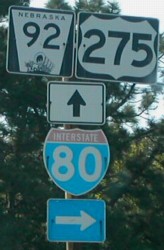
- Oh, that's tempting. Since I mainly write about highways, any highway pics you can get would be great. I don't have any free pics of Iowa Highway 165 in Carter Lake (it's about a half-mile north of the Qwest Center) so, a picture of the Iowa welcome sign in Carter Lake would be great. Also, the US 275/Highway 92 bridge just opened this year, so a picture of that would be great as well. While you're around US 275, could you get a picture of a sign assembly on the Nebraska side. Whatever you get, I'm sure it'll be great. Also, thanks for the offer! –Fredddie™ 22:52, 9 September 2010 (UTC)
- Ok, if you have a lot of highway pics you want, take advantage of me going across state. What do you want on 165? like a highway sign or what do you like as far as pics?
- On your link, all i see is a note that says "image hosted by angel fire", so no pic shown. CTJF83 chat 22:59, 9 September 2010 (UTC)
- Oh, sorry. As for Iowa 165, the third picture down is what I had in mind. And as for the sign assembly, this (third image down, again) is what I have in mind. Both of those are not-free images, so I can't use them. Really, though, anything you can get is fine by me. –Fredddie™ 23:27, 9 September 2010 (UTC)
- this bridge? you want a pic of? Give me more high ways you want pics of! :) Like I side, take advantage!! CTJF83 chat 23:34, 9 September 2010 (UTC)
- Yes, that's the old bridge. The new bridge was built right next to it. Pictures of the Kennedy Freeway (US 75) and I-480 would be nice to have. I'd really like a picture of the I-480/US 75 interchange in downtown Omaha. I'm actually not very familiar with Omaha/Council Bluffs, so I can't think of anything more. –Fredddie™ 23:42, 9 September 2010 (UTC)
- Anything else along 80, the whole 306 miles you want? Iowa City/Coralville, Des Moines, etc, you have a list of highways that need photos? CTJF83 chat 23:48, 9 September 2010 (UTC)
- I don't know, I think I-80's pretty boring and the article already has a good picture for how boring it is. Maybe a picture of a rest area? Maybe a picture of an old one compared to a new one? I'd love for you to take pictures of every highway at every exit along I-80, but I don't want to turn a 5-hour drive into 7-8 hours. I have some ideas for pics around the QCs, but that can wait. –Fredddie™ 00:03, 10 September 2010 (UTC)
- Anything else along 80, the whole 306 miles you want? Iowa City/Coralville, Des Moines, etc, you have a list of highways that need photos? CTJF83 chat 23:48, 9 September 2010 (UTC)
- Yes, that's the old bridge. The new bridge was built right next to it. Pictures of the Kennedy Freeway (US 75) and I-480 would be nice to have. I'd really like a picture of the I-480/US 75 interchange in downtown Omaha. I'm actually not very familiar with Omaha/Council Bluffs, so I can't think of anything more. –Fredddie™ 23:42, 9 September 2010 (UTC)
- this bridge? you want a pic of? Give me more high ways you want pics of! :) Like I side, take advantage!! CTJF83 chat 23:34, 9 September 2010 (UTC)
- Oh, sorry. As for Iowa 165, the third picture down is what I had in mind. And as for the sign assembly, this (third image down, again) is what I have in mind. Both of those are not-free images, so I can't use them. Really, though, anything you can get is fine by me. –Fredddie™ 23:27, 9 September 2010 (UTC)
All of the bridges in the QCs could have their pictures updated. If you look at Flickr, there are some good pics out there, but none of the good ones are CC/PD. I'm thinking of a picture of the Government Bridge from the Skywalk to Nowhere, a picture of the I-74 bridge from the Abbey, the truck-eating bridge, a picture of River Drive from the ballpark. I can go on, and that's just the Iowa side. –Fredddie™ 00:52, 10 September 2010 (UTC)
- I can definitely get to those after Sunday when I return...if you want to make me a list of pics you want in the QC, that'd be cool. CTJF83 chat 05:17, 10 September 2010 (UTC)
- What do you think of combining File:Iowa165.svg and File:Iowa165 inset.svg into one pic? CTJF83 chat 01:04, 14 September 2010 (UTC)
Re: Lists of Highways in Counties
First, thanx for pointing out that Bannered US 75 page, hadn't seen it before. I had no idea there were any separate US 75 graphics for IA on Wikipedia. Ever since I saw a 'list of highways in a county' page for the first time, I've wondered if anything could be done to make them, well, less cumbersome. Especially to the editor that comes up with the page originally. I guess anything to tweak it for the better would be good. I think you're right, though, about leaving the FMs/RMs as some kind of chart--way too many of them (some counties have 30, 35, +) to be viewed as straight-ahead prose in an article.
BTW, what part of IA? I am from Cedar Rapids originally. I've often wondered what things would have been like for me if my parents hadn't been transferred with their jobs all those years ago to TX. I've only been back once, in the late 1970s for a couple of days; I-380 was being built through town at the time. Awtribute (talk) 21:52, 15 September 2010 (UTC)
- Glad I could show you. Now, I've noticed some counties have their own lists, but there are some regional lists as well. Seems redundant to me. Might be a good idea to work with Fortguy (talk · contribs) since he's created a number of the regional lists. There is no sense in duplicating each other's work.
- Also, I live in Des Moines now, but I grew up in the Clinton area. –Fredddie™ 22:44, 15 September 2010 (UTC)
Q about the map you created for me
Fredddie, Thanks for the map of Thistle, Utah, that you created for me. The article is now at WP:FAC. I've been asked about the source data for this map (again). I would take it as a compliment, that nobody believes the USRD project is capable of producing such quality maps on our own. Anyways, do you remember where the alignment of the railroad came from? Was that in one of the GIS layers, freehand? Thanks again Dave (talk) 17:06, 23 September 2010 (UTC)
- I found the SGID page that I used and added links to every shape file. Turns out the data is PD so I can't really claim a CC license on the image. –Fredddie™ 18:23, 23 September 2010 (UTC)
- Thanks for doing that, both creating the map, and chiming in at the FAC. Dave (talk) 23:23, 23 September 2010 (UTC)
- You can claim a CC license on the map, since it was your creative vision that selected what was needed to produce the illustration. Just like a photographer selects lighting, angles, camera settings, lenses, filters, etc, a cartographer selects colors, layout, details to include or exclude. You're free to claim a CC license on your work, or release it into the PD, even if the raw GIS data came from PD sources. Imzadi 1979 → 23:35, 23 September 2010 (UTC)
- Thanks for doing that, both creating the map, and chiming in at the FAC. Dave (talk) 23:23, 23 September 2010 (UTC)
US 30 in IA
Hi Fred- It is a cool movie. I like the jerry-rigged wooden camera tower on the station wagon; they probably won't let you do that today. A recent publication by a co-worker that may interest you: Iowa’s Historic Automobile Roads A National Register Study of Pre-1948 Arterial Highways Bill Whittaker (talk) 02:37, 27 September 2010 (UTC)
- I laughed when I saw the camera tower. Thanks, I'll give that publication a look. I'm currently writing about US 6. Lots of interesting stuff about how that route came to be. –Fredddie™ 02:47, 27 September 2010 (UTC)
Per the peer review of Davenport, can you help me source the GIS data you said was the source? I'm totally unfamiliar with what it is. Thanks, CTJF83 chat 06:17, 29 September 2010 (UTC)
Maps
(I'll definitely get those pictures you requested of me) Do you know how to label buildings on a map so they link to the building article, similar to how the states are linked on this map? If so, I think I want buildings linked on File:Downtown Davenport.jpg to the articles. Thanks, CTJF83 chat 21:58, 7 October 2010 (UTC)
- I haven't played with imagemaps, but mw:Extension:ImageMap has some tips. –Fredddie™ 04:14, 8 October 2010 (UTC)
For LeClaire bend on US 67, do you mean bend "A" or "B"?...also for roads, do you want pictures of the signs or the actual road? CTJF83 chat 15:17, 10 October 2010 (UTC)
- B. Signs are nice, but not a requirement. Sure is a lovely day to take pics! –Fredddie™ 22:36, 10 October 2010 (UTC)
- For ILL 84, I was thinking of the opposite side of the river from point B, but that's low priority. –Fredddie™ 22:39, 10 October 2010 (UTC)
- Ok, got the local bridge pics, minus 74 for now. So what exactly do you want for highway 22 pics? I took a few pics of the 22 sign and then some of the road, lol, which do you want? CTJF83 chat 23:20, 10 October 2010 (UTC)
- I was thinking something along the river. –Fredddie™ 23:21, 10 October 2010 (UTC)
- Ok, I can retake some...so the highway with a river backdrop. CTJF83 chat 23:45, 10 October 2010 (UTC)
- File:Truck Eating Bridge (Davenport, Iowa).jpg is ready...not sure what page you want it on...I'll get the other ones soon. CTJF83 chat 16:47, 12 October 2010 (UTC)
- Ok, I can retake some...so the highway with a river backdrop. CTJF83 chat 23:45, 10 October 2010 (UTC)
- I was thinking something along the river. –Fredddie™ 23:21, 10 October 2010 (UTC)
- Ok, got the local bridge pics, minus 74 for now. So what exactly do you want for highway 22 pics? I took a few pics of the 22 sign and then some of the road, lol, which do you want? CTJF83 chat 23:20, 10 October 2010 (UTC)
- For ILL 84, I was thinking of the opposite side of the river from point B, but that's low priority. –Fredddie™ 22:39, 10 October 2010 (UTC)
.jpg)
That is AWESOME! I love how you can see a notch where trucks have hit it repeatedly. –Fredddie™ 23:40, 12 October 2010 (UTC)
- LOL, right, not like there isn't 3 height signs, several caution lines, not to mention 2 electronic signs coming down the hill telling big trucks to turn before than as they approach the signs...yet it still gets hit! CTJF83 chat 04:10, 13 October 2010 (UTC)
PR-501 shiled
Hi, the shield shows here >>> PR-501, but not in the infobox here >>> PR-123. Do you know what could be wrong? Thanks, Mercy11 (talk) 14:53, 17 October 2010 (UTC)
- Right. But then trying to fix the PR-139 shield icon found the infobox of PR-10 with ter, sec, PR or urban, doesn't yield the desired primary route shiled icon. Instead they yield: no icon at all, a little square box with an "x" in it, a big you-made-a-boo-boo box, and another bif boo-boo box. Why? Mercy11 (talk) 00:41, 18 October 2010 (UTC)
Shield Request
I have a request for a shield: The Puerto Rico Autopista shield used on PR-22, PR-52, PR-53, and PR-66. Here is what it looks like: [8].
![[8]](http://www.hawaiihighways.com/PR-autopista-newstylesign.jpg)
To incorporate them into the infoboxes, perhaps we can put the Autopista shield to the left of the route number shield rather than above it. ANDROS1337 16:40, 19 October 2010 (UTC)
- Hmm. That's certainly doable, but it may take some time.
 Accepted –Fredddie™ 21:38, 19 October 2010 (UTC)
- I have 1 question/comment plus 1 comment: Question/Comment: Can we call the middle sign HERE a road "shield"? That emblem serves to identify, not one unique road but, instead, a group of roads. These are roads that have in common certain building/design criteria, and they are more or less equivalent to what is informally known in the U.S. as "superhighways". With that said, I do not believe what user Andros is calling "The Puerto Rico Autopista (PRA) shield" is really a road route marking shield, and I am afraid it may be mistakenly interpreted that way by the uninformed reader. In that context it could be -- mistakenly -- thought of a route shield comparable to the, say, GS Parkway shield (
 ), but it is not, because the GS Parkway shield (a "true" shield, imo) points to 1 unique road, but the so-called "Puerto Rico Autopista shield" (but more correctly, "The Puerto Rico Autopista emblem) does not identify a single road. It, rather, advertises a TYPE of road. And thus the manner that the PRA emblem is used in PR roadways is not really for directorial purposes, but more as an advertising means of sorts. I am not sure where this leads as far as the wikipedia US roads project practices, standards, guidelines, and what not, but felt it was necessary to ask the question.
- I have 1 question/comment plus 1 comment: Question/Comment: Can we call the middle sign HERE a road "shield"? That emblem serves to identify, not one unique road but, instead, a group of roads. These are roads that have in common certain building/design criteria, and they are more or less equivalent to what is informally known in the U.S. as "superhighways". With that said, I do not believe what user Andros is calling "The Puerto Rico Autopista (PRA) shield" is really a road route marking shield, and I am afraid it may be mistakenly interpreted that way by the uninformed reader. In that context it could be -- mistakenly -- thought of a route shield comparable to the, say, GS Parkway shield (
- My comment: THIS layman and unofficial site makes references to the fact that on "Labor Day weekend 2002" the PR Autopista emblem was an older way of signing Autopistas. I can categorically assure you that the Autopistas emblem (the generic one under discussion here, not necessarily the one with the route number in the lower 1/2 of the shield) was first used in 1968, and that's over 40 years ago. But my point here is that it seems to me that the Autopistas emblem seems to be in lesser and lesser use nowadays. Its use, imo, has been declining with the passing of time, and starting some 10 years ago, maybe longer. If there is something that PR roads seem to be notorious for, is the lack of an uniform, enduring, permanent standard way for road signs, particularly road route numbers. It would be time not so well spent to develop the emblem in question, just to find out that PR DOT will be dropping it altogether shortly. Or worse, that it has already been dropped, but DOT has not taken down the signs yet. This last scenario is a FACT, in PR. It is also discussed briefly alluded to in the Hawaii Highways citation HERE. IMO, the right way to go about this is to get a citation from the PR DOT that categorically states the emblem continues in use and that the it, PR DOT, continues to actively deploy such signs.
- Regards, Mercy11 (talk) 00:45, 20 October 2010 (UTC)
- Just a comment, but we roadgeeks need to really watch our terminology better. A "shield" is a shape. That shape is used for several markers, like the marker for US Highways/US Routes or the Interstates. Several states and territories have shield-shaped markers. I would never call a marker on the side of the road a "shield" unless it was... shield-shaped. Now, there are signs similar in purpose to the marker requested above. There is File:Eisenhower Interstate System.svg which is in use sporadically on the Interstate Highway System, but it is not posted along side reassurance markers consistently. As such, the marker requested above would be good to include on an article about PR's Autopistas, but I wouldn't add it to the infobox of any article. If the marker has fallen out of usage, including it for historical and illustrative purposes still isn't a bad thing. Imzadi 1979 → 01:01, 20 October 2010 (UTC)
- (edit conflict)For what it's worth, we should be calling them route markers, not shields. I personally wouldn't consider the autopistas sign to be a route marker, but that's my opinion. I do think there would be some value in having the autopistas sign created. I swear when I found the references for the PR route markers, there was another design drawing for the autopistas sign. Alas, I can't find it now.
- Regards, Mercy11 (talk) 00:45, 20 October 2010 (UTC)
- The sign has definitely NOT fallen out of use. Puerto Rico's newest tolled expressway, PR-66, uses it. ANDROS1337 01:30, 20 October 2010 (UTC)
Exit list for L-28B on List of Nebraska Connecting Link, Spur, and Recreation Highways Part 2
Just curious why you eliminated that particular exit list. It's not a random exit list, which was what your description of it was when you removed it. It is a real freeway, one you can take to go from Omaha to Fremont, Nebraska. Of course, it would be helpful if NDOR came up with one number for that particular freeway. DandyDan2007 (talk) 08:07, 6 September 2010 (UTC)
- If I recall, it was horrifically out of place on that list. I normally don't advocate the links and spurs having their own articles, but this would be an instance where the project would benefit from an L-28B article. –Fredddie™ 12:04, 6 September 2010 (UTC)
- Thanks, if I ever get time, I'd make an article. DandyDan2007 (talk) 12:59, 7 September 2010 (UTC)
The previous conversation above is from your 2010 archive page. I would love to make an article for that highway, but I've been in and out of the hospital and don't have time and energy to put in research for such an article, so if you want to make it, do it. DandyDan2007 (talk) 06:06, 21 October 2010 (UTC)
- I can take a stab at it, but I don't know much more than what the NDOR log book tells me about Nebraska highways. –Fredddie™ 15:48, 21 October 2010 (UTC)
- One more issue, what would the article be called?
Nebraksa Link Highway 28B?Nebraska Highway L-28B?–Fredddie™ 15:49, 21 October 2010 (UTC)- The list redirects fro Nebraska Link 28B, so I'll use that. –Fredddie™ 15:55, 21 October 2010 (UTC)
- One more issue, what would the article be called?
Fall 2010 USRD newsletter
| ||
| Volume 3, Issue 3 • Fall 2010 • About the Newsletter | ||
|
|
|
| Archives • Newsroom • Full Issue • Shortcut: WP:USRD/NEWS | ||
Re:MN county road lists
Replied on my talk page.
BTW, the Washington County shields you made recently need to be the pentagon, not the square. Washington uses the pentagon for CSAHs (routes 1-39, except suffixed ones) and the square for the others.
As for the rest, I still need to get the usage guide finished, I've only been adding to it when I have to look one up anyway for a junction list I'm doing. Google Maps street view makes my computer fans run full tilt so I don't like to spend too much time on it. --Sable232 (talk) 19:20, 24 October 2010 (UTC)
- I saw and I will fix. I made a whole mess of squares that day, but I can make pentagons just as easily. –Fredddie™ 22:13, 24 October 2010 (UTC)
Pics
Headed to Clinton, shortly, after lunch! :) CTJF83 chat 17:35, 31 October 2010 (UTC)
- Please tell me which picture of the Gateway Bridge, and of I 74 Bridge you like best, and I'll upload it on Commons. CTJF83 chat 01:09, 1 November 2010 (UTC)
- Thank you! Go ahead and upload the following: 100_0765, 100_0757, 100_0722, and 100_0716. –Fredddie™ 01:15, 1 November 2010 (UTC)
- Ok, I'm not at all satisfied with my 67/30 pics, due to the sun, so I'm gonna retake those soon. I have IL 84, hope it is good, nothing much on the highway, and a few of the 67 bend in LeClaire, plus a new one for I-80 bridge, all uploading shortly. CTJF83 chat 01:17, 1 November 2010 (UTC)
- Throw them up on Flickr anyway. WP:GL can work wonders... –Fredddie™ 01:22, 1 November 2010 (UTC)
- Are you good at editing pics? I see I had sun issues with Gateway too...damn sun! CTJF83 chat 01:25, 1 November 2010 (UTC)
- Throw them up on Flickr anyway. WP:GL can work wonders... –Fredddie™ 01:22, 1 November 2010 (UTC)
- Ok, I'm not at all satisfied with my 67/30 pics, due to the sun, so I'm gonna retake those soon. I have IL 84, hope it is good, nothing much on the highway, and a few of the 67 bend in LeClaire, plus a new one for I-80 bridge, all uploading shortly. CTJF83 chat 01:17, 1 November 2010 (UTC)
- Thank you! Go ahead and upload the following: 100_0765, 100_0757, 100_0722, and 100_0716. –Fredddie™ 01:15, 1 November 2010 (UTC)
.jpg)
Question about the USRD logo
Did you make that logo or do you know who did? I would like to create a banner for WikiProject United States and the logo you presented looks very professionally done. I was also considering a logo as well but I decided to stick with the "logo" as the US FLAG. Its makes it easily identifiable as a US topic. --Kumioko (talk) 05:19, 4 November 2010 (UTC)
- Scott5114 (talk · contribs) created it as a part of File:USRD Newsletter header.svg. I just trimmed it down from that graphic for use in Wikipedia:WikiProject U.S. Roads/Userbox. Imzadi 1979 → 05:27, 4 November 2010 (UTC)
- (edit conflict) On my own talk page, even! Thanks for the complement! That's the kind of work we do regularly at WP:USRD. –Fredddie™ 05:29, 4 November 2010 (UTC)
BS
|
|
The Original Barnstar | |
| Too often great editors like you are overlooked and not given the credit deserved for all their great contributions. So I am awarding you this barnstar to let you know I greatly appreciate all you do for Wikipedia, and please keep up the outstanding work!! CTJF83 chat 03:09, 17 November 2010 (UTC) |
The Signpost: 22 November 2010
- News and notes: No further Bundesarchiv image donations; Dutch and German awards; anniversary preparations
- Book review: The Myth of the Britannica, by Harvey Einbinder
- WikiProject report: WikiProject College Football
- Features and admins: The best of the week
- Election report: Candidates still stepping forward
- Arbitration report: Brews ohare site-banned; climate change topic-ban broadened
- Technology report: Bugs, Repairs, and Internal Operational News
The Signpost: 29 November 2010
- In the news: Fundraising banners continue to provoke; plagiarism charges against congressional climate change report
- WikiProject report: Celebrate WikiProject Holidays
- Features and admins: The best of the week
- Election report: Voting in full swing
- Arbitration report: New case: Longevity; Biophys topic ban likely to stay in place
- Technology report: Bugs, Repairs, and Internal Operational News
Proj/Project
Thanks. --Admrboltz (talk) 22:44, 4 December 2010 (UTC)
- No problem. It's amazing what secrets those hidden categories can reveal. –Fredddie™ 23:46, 4 December 2010 (UTC)
The Signpost: 6 December 2010
- News and notes: ArbCom tally pending; Pediapress renderer; fundraiser update; unreferenced BLP drive
- WikiLeaks: Repercussions of the WikiLeaks cable leak
- WikiProject report: Talking copyright with WikiProject Copyright Cleanup
- Features and admins: Birds and insects
- Arbitration report: New case: World War II
- Technology report: Bugs, Repairs, and Internal Operational News
BC 97
FYI, I've updated the FUR to include the Alaska Highway, given that 97 is the official designation for the Alaska Highway in British Columbia. --Ckatzchatspy 07:44, 9 December 2010 (UTC)
At some point in the future, I plan on running Highway Marker Bot through the rest of Canada, but first I need templates. The road sign of Manitoba recently changed, and I have created a new blank. Any objects to me uploading a new template over File:Manitoba X.svg? Cheers. --Svgalbertian (talk) 16:28, 9 December 2010 (UTC)
.svg)
- Absolutely not; go ahead and do your thing. There are also templates for secondary highways and Winnipeg routes. –Fredddie™ 16:34, 9 December 2010 (UTC)
Your FAC
FYI, per the instructions page at FAC "Use of graphics or templates including graphics (such as ![]() Done and
Done and ![]() Not done) is discouraged, as they slow down the page load time." With that said, I wish you the best. I don't think I'll vote, as I participated in the A class review. But I'll keep my eye out and help where possible. Dave (talk) 22:36, 9 December 2010 (UTC)
Not done) is discouraged, as they slow down the page load time." With that said, I wish you the best. I don't think I'll vote, as I participated in the A class review. But I'll keep my eye out and help where possible. Dave (talk) 22:36, 9 December 2010 (UTC)
Virginia State Route 198 Image
Fallschirmjäger ✉ 15:04, 12 December 2010 (UTC)
The Signpost: 13 December 2010
- Rencontres Wikimédia: Wikimedia and the cultural sector: two days of talks in Paris.
- WikiProject report: WikiProject Algae
- Features and admins: The best of the week
- Election report: The community has spoken
- Arbitration report: Requested amendment re Pseudoscience case
- Technology report: Bugs, Repairs, and Internal Operational News
Shields (various)
I've got a few questions/requests.
First, I'd like a set of 1926 US shields for Minnesota. Primarily, File:US 10N (MN).svg and File:US 10S (MN).svg need to be replaced, since the routes were deleted in 1934 and these style shields never existed. Is it possible for the bot to upload a new version of an existing file? If that's the case I suppose it's easiest to let the bot do the lot of them, we'd just need a sample for it.
.svg)
.svg)
- I agree completely. The trouble is that I don't have the block font required to make them. I have a block font, but it sucks. –Fredddie™
Second one: I think you misunderstood me about the generic square shields... I didn't mean I wanted to code them into the template before the shields exist, I'll be going back over most of the articles anyway and can add them in then. Even if it is too difficult to get them to work in the jct template, they can always be added manually.
- I don't recall coding in anything. I changed the USH shields on MN 218 to US 1961 after the shields were created and template set up. That's it. –Fredddie™
Lastly, I'm thinking of eventually making an RCS-style list of the 1926-33 highways (aka "Constitutional Routes"), which will need a set of those shields (as well as the 1926 US route shields). I'll find a few examples if you want.
Thanks, let me know what you think. --Sable232 (talk) 05:11, 14 December 2010 (UTC)
Project Iowa news

called Wikipedia:WikiProject Iowa/Communities
has been activated.
Hi, you are receiving this notice because you are a member of WikiProject Iowa. I hope you will take the time to check out the developing division called Communities (pre-named and previously red-linked). Keep up the good work.
Please click on the links in the GOOD NEWS notice. RifeIdeas Talk 00:44, 18 December 2010 (UTC)
The Signpost: 20 December 2010
- News and notes: Article Alerts back from the dead, plus news in brief
- Image donation: Christmas gift to Commons from the State Library of Queensland
- Discussion report: Should leaked documents be cited on Wikipedia?
- WikiProject report: Majestic Titans
- Features and admins: The best of the week
- Arbitration report: Motion passed in R&I case; ban appeals, amendment requests, and more
- Technology report: Bugs, Repairs, and Internal Operational News
Ho ho ho
| Merry Christmas to you! My my, how this year has flown by, and hopefully next year is prosperous for us all. And may the GA and FA gods shine upon yourself and the project in the new year. --Admrboltz (talk) 01:42, 25 December 2010 (UTC) |
The Signpost: 27 December 2010
- Ambassadors: Wikipedia Ambassador Program growing, adjusting
- WikiProject report: WikiProject National Basketball Association (NBA)
- Features and admins: The best of the week
- Technology report: Bugs, Repairs, and Internal Operational News
Thank you
| Thank you for your work on highway articles across the world in 2010, whether it was converting articles to {{Infobox road}} or working on converting articles to WP:RJL or building the WP:HWY assessment infrastructure. Even though we still have a long ways to go, and my goal of a universal {{Infobox road}} and WP:RJL was not realized, we have made many improvements that will go a long way towards improving the state of the English Wikipedia highway articles. --Rschen7754 21:27, 28 December 2010 (UTC) |