
User talk:Dylan620/Hurricane
This is where I receive copies of the WikiProject Tropical cyclones newsletter.
Tropical cyclones WikiProject Newsletter #22[edit]
Number 22, November 2, 2008
The Hurricane Herald
This is the monthly newsletter of WikiProject Tropical Cyclones. The Hurricane Herald aims to give a summary, both of the activities of the WikiProject and global tropical cyclone activity. If you wish to change how you receive this newsletter, or no longer wish to receive it, please add your username to the appropriate section on the mailing list. This newsletter covers all of October 2008.
Please visit this page and bookmark any suggestions of interest to you. This will help improve monitoring of the WikiProject's articles.
Storm of the month
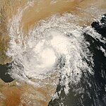
Deep Depression ARB 02 caused the 2008 Yemen floods. On October 19 the IMD noted that an area of low pressure which located to the south east of Salalah, Oman had intensifed in to a tropical depression and was assigned the number ARB 02. On October 21 IMD updated the system to a Deep Depression while it lay 700 km south of Salalah, Oman near the east coast of Somalia. It lost its strength while crossing the Gulf of Aden due to entry of dry air and land interaction as it passed close to the northeastern coast of Somalia. It later was downgraded to a Depression, named TC 03B by the JTWC. On October 24 it made landfall on the south-eastern coast of Yemen, leaving at least 26 civilians and six soldiers dead while trapping hundreds of people due to flooding and torrential rainfalls. The latest figure of casualties is of 184 persons dead and 100 others missing, mostly from the region of Hadhramawt, where the storm made landfall. A total of 733 houses were destroyed in the governorates of Hadhramaut and Al Mahrah, while 22,000 people were displaced. The Yemeni Government declared the two aforementioned governorates as disaster zones.
Other tropical cyclone activity
- Atlantic Ocean– In the Atlantic, four tropical cyclones formed this October. Tropical Storm Marco formed in the Bay of Campeche on October 6. It made landfall on October 8 and is one of the smallest Atlantic tropical cyclones since 1988. Tropical Storm Nana formed October 12 in the middle of the open Atlantic. It had no impact anywhere and dissipated October 14. Hurricane Omar formed October 13 and dissipated October 18. Eventually peaking as a Category 4 hurricane, Omar passed through the Lesser Antilles twice, including once near peak intensity. Fortunately, it caused only one indirect death. Tropical Depression Sixteen formed on October 16 and dissipated two days later after making landfall. It killed 16 to 20 people in Central America.
- Eastern Pacific Ocean– In the eastern north Pacific, three tropical cyclones formed this October. Hurricane Norbert formed October 3 and dissipated October 12. The strongest storm thus far this season, Norbert is the first hurricane to strike the west coast of the Baja California Peninsula since 1968. Eight deaths have been blamed on the hurricane.. Tropical Storm Odile formed October 8 and paralleled the coast of Mexico before dissipating on October 12. Tropical Depression Seventeen-E formed on October 23 and dissipated the next day without impacting land.
- Western Pacific Ocean– In the western north Pacific, two tropical cyclones formed. Tropical Storm Bavi formed October 18 in the open Pacific. It never came near land and dissipated three days later. Tropical Depression Twenty Two-W formed on October 13 in the Gulf of Tonkin and made landfall on October 15. It dissipated inland the next day.
- North Indian– In the northern Indian Ocean, two cyclones formed. Besides Deep Depression ARB 02, which caused flooding that killed 184 people in Yemen, Cyclonic Storm Rashmi formed October 25 and made landfall three days later. It killed two people.
- South-West Indian – The 2008-09 South West Indian Ocean Season got off to an early start with two pre season zones of disturbed weather. The first zone of disturbed weather formed on October 6 and did not develop any further. Whilst the second zone of disturbed weather formed on October 16 and developed in to Moderate Tropical Storm Asma.
Member of the month

The October member of the month is Hurricanehink. Since joining the project near its inception, Hurricanehink has been involved in bringing forty two articles, eighteen lists and six topics to featured status. Just this month, Hurricanehink was mentioned in the Signpost Dispatch. Hurricanehink has also been the regular distributor for this newsletter.
New members
New and improved articles
- There were new pieces of Featured content : Hurricane Dean (FT), Timeline of the 2007 Pacific hurricane season, Tropical Storm Hanna (2002), Timeline of the 2006 Pacific hurricane season
- New Good articles include: Hurricane Hernan (2008), Effects of Tropical Storm Allison in Texas, Hurricane Frances, Hurricane Joyce (2000), Hurricane Elida (2008), Tropical Storm Lester (2004), Tropical Storm Arlene (1959), Tropical Storm Rosa (2006), Cyclone Daman, Hurricane Donna, Hurricane Rosa (1994), 1994 Pacific hurricane season, Hurricane Fern (1971), Tropical Storm Frances (1998), and 1982 Pacific typhoon season
- New storm articles include: Hurricane Marie (2008) Tropical Storm Dora (2005), Tropical Storm Karina (2008), Hurricane Norbert (2008), Cyclone Cliff, Tropical Storm Arlene (1959), Tropical Storm Rosa (2006), Hurricane Otis (2005), Tropical Storm Kika (2008), Cyclone Elisa (2008), Tropical Storm Lidia (2005), Tropical Depression Fifteen (2007), Tropical Depression Seven (2002)
- New non-storm articles include: 1966 Pacific hurricane season, 1854 Atlantic hurricane season, Timeline of the 2003 Pacific hurricane season, 2009 North Indian Ocean cyclone season
Main Page content
- Entries from articles: Tropical Storm Lester (2004), Hurricane Rosa (1994), Tropical Storm Kirsten (1966), 1854 Atlantic hurricane season appeared on the Main Page in the Did you know column during October.
- Meteorological History of Hurricane Wilma appeared as Today's Featured Article on October 26.
- 2008 Yemen floods, caused by Deep Depression ARB 02, appeared on the Main Page in the In the News section.
Storm article statistics
| Grade | Jul | Aug | Sep | Oct |
|---|---|---|---|---|
| 42 | 46 | 47 | 48 | |
| 18 | 18 | 19 | 19 | |
| 139 | 145 | 161 | 187 | |
| B | 15 | 14 | 17 | 12 |
| C | 98 | 99 | 107 | 113 |
| Start | 202 | 197 | 201 | 201 |
| Stub | 10 | 15 | 19 | 20 |
| Total | 524 | 537 | 571 | 600 |
| ω | 2.94 | 2.92 | 2.92 | 2.88 |
| percentage ≥Less than C |
40.5 | 39.5 | 38.5 | 36.8 |
| percentage ≥GA or better |
38.0 | 39.3 | 39.8 | 42.3 |
Project News
A discussion concerning sandboxes for next year's articles has begun. Please consider working on sandboxes so they will be ready to publish. As tropical cyclones can form at any time in the western Pacific and northern Indian Oceans, these two season's should be made ready for cyclones by December. Ideally, due to the possibility of pre-season storms, the eastern Pacific and Atlantic seasons should also be ready by then, but they should at least be ready by the northern-Hemisphere antipeak in late February and early March. Seasons for the years 2010 to 2015 should be given the name "Post-2009 {ocean name} {cyclone term} seasons", as in "Post 2009 Atlantic hurricane seasons".
A category for tropical cyclone articles of very-low importance has been introduced. Although discussion is still ongoing, a rating of very-low-importance will generally be given to weak cyclones that do not have impact or set any sort of record.
Editorial
This month, our usual editor, Hurricanehink, has been on a semi-wikibreak until further notice. I am filling in as editor and distributor on an interim basis. The newsletter will continue as normal during that time. Thank you. Miss Madeline | Talk to Madeline 00:49, 2 November 2008 (UTC)
Miss Madeline | Talk to Madeline 02:01, 2 November 2008 (UTC)
Comments: Thank you, Madeline! But to tell you the truth, I would have voted for Norbert being the storm of the month. Or Omar. :-) --Dylan620 (Home • yadda yadda yadda • Ooooohh!) 12:36, 2 November 2008 (UTC)
Tropical cyclones WikiProject Newsletter #23[edit]
Number 23,
The Hurricane Herald
This is the monthly newsletter of WikiProject Tropical Cyclones. The Hurricane Herald aims to give a summary, both of the activities of the WikiProject and global tropical cyclone activity. If you wish to change how you receive this newsletter, or no longer wish to receive it, please add your username to the appropriate section on the mailing list. This newsletter covers all of November & December 2008.
Please visit this page and bookmark any suggestions of interest to you. This will help improve monitoring of the WikiProject's articles.
Storm of the month
Hurricane Paloma
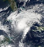
Hurricane Paloma was the second most powerful November hurricane on record in the Atlantic Basin, behind Hurricane Lenny in 1999. It was the third and final major hurricane to hit Cuba in 2008, being the first time that three major hurricanes have struck Cuba in one season. It also marked the first time that at least one major hurricane formed in every month of the hurricane season from July to November, with only June not having a major hurricane this season.
Hurricane Paloma was also the last Tropical Depression of the 2008 season, and caused at least $1.4 billion in damage and was responsible for at least one direct death.
Other tropical cyclone activity
- Eastern Pacific Ocean– Tropical Storm Polo was the only Tropical Storm to form during November and December.
- Western Pacific Ocean – There were five tropical depressions during the last two months of the 2008 Pacific typhoon season. Though only four of them developed into Tropical storms with only Dolphin becoming a Typhoon.
- North Indian– There were three Tropical Depressions during the last two months of the 2008 North Indian Ocean cyclone season, however there were only two that officially became Tropical Storms being named Khai-Muk and Nisha.
- South Indian– Cyclone Bernard was the first cyclone of the year to move into the Australian Region from the Southwest Indian Ocean. Forming on early on November 19 it quickly intensified into a Moderate Tropical Storm the next day, however as it moved westward it weakened into a Tropical Depression and moved into Australia's Bureau of Meteorology's area of responsibility and dissipated later on November 21.
- Australian - There were four tropical lows during November and December with Tropical Low ex Bernard moving into the Australian Region from the South-West Indian Ocean. Two of the Lows developed into Tropical Cyclones being named Anika and Billy respectively. Anika intensified into a category two cyclone whilst Cyclone Billy became a Severe Tropical Cyclone after it had affected Northern Australia.
- The 2008–09 South Pacific cyclone season got off to an slow start during November and December, with three Tropical Disturbances forming during December. Only one of the tropical disturbances developed into a tropical depression.
Member of the month
The November/December member of the month is Thegreatdr, who has been a steady editor within the project for the past few years. Lately, the user's contributions include improving some of the Pacific Typhoon season articles from the 1980s. Thegreatdr has also tipped us off about going on's at the National Hurricane Center and the Hydrometeorological Prediction Center.
New members
- Aquamelli * DavidWS * Ramisses * Renereynoso * VeronicaPR * Neutralhomer * VOFFA * Catalan * HurricaneSpin * HERB * NuclearWarfare
New and improved articles
- There were new pieces of Featured content : Timeline of the 2005 Pacific hurricane season, Tropical Storm Erick (2007), Tropical Storm Gabrielle (2007), Timeline of the 2003 Atlantic hurricane season, Timeline of the 1983 Atlantic hurricane season, Timeline of the 1982 Atlantic hurricane season
- 1994 Pacific hurricane season became the project's first Good topic.
- New Good articles include: 1981 Pacific typhoon season, 1983 Pacific typhoon season, 1994 Pacific typhoon season, Hurricane Karl (1998), Tropical Depression One-C (2005), Tropical Storm Dorothy (1970), Tropical Storm Hermine (1998), Cyclone Gene
- New storm articles include: Tropical Storm Guchol (2005), Hurricane Paloma (2008), Hurricane Douglas (2002), Hurricane Florence (1994), Tropical Storm Vongfong (2008), Cyclone Rosie (2008), Tropical Storm Becky (1970), Hurricane Hector (2006), Hurricane Karl (1998)
- New non-storm articles include: Timeline of the 2003 Atlantic hurricane season, Timeline of the 1995 Atlantic hurricane season, Timeline of the 1983 Atlantic hurricane season, Timeline of the 1982 Atlantic hurricane season, 2009 Pacific typhoon season, Timeline of the 2001 Atlantic hurricane season
Main Page content
- Facts from 2008's Cyclone Rosie, 1970's Tropical Storm Becky, 2005's Tropical Depression One-C & 1998's Hurricane Lisa appeared in the Did You Know? section of the Main Page during November.
- Hurricane Paloma appeared on the Main Page in the In the News section.
- Facts from 1998's Hurricane Karl, 2006's Tropical Storm Olivia & 1969's Hurricane Holly appeared in the Did You Know? section of the Main Page during December.
Storm article statistics
| Grade | Sep | Oct | Nov | Dec |
|---|---|---|---|---|
| 47 | 49 | 49 | 50 | |
| 19 | 19 | 19 | 19 | |
| 161 | 187 | 198 | 202 | |
| B | 17 | 13 | 21 | 22 |
| C | 107 | 119 | 118 | 122 |
| Start | 201 | 204 | 210 | 210 |
| Stub | 19 | 19 | 16 | 17 |
| Total | 571 | 613 | 631 | 642 |
| ω | 2.92 | 2.88 | 2.87 | 2.87 |
| percentage ≥Less than C |
38.5 | 36.4 | 35.8 | 35.4 |
| percentage ≥GA or better |
39.8 | 42.1 | 42.2 | 42.2 |
Project News
During the last two months there have been several important discussions of which some are still seeking contributions from members. These include discussions about:
- Project Importance - Is it better to rate Storm Importance by basin or by overall importance? - There seems to be a consensus to rate storm importance on a case by case basis, though there still needs to be a bit more discussion on this matter.
- Prominent units within TC articles: Imperial or SI? - Which should be the prominent unit outside the Atlantic and Eastern Pacific Basins, Knots or MPH? Generally people think that Knots should not be used except in the general science articles and infoboxes.
- ACE - Where and how, should it be used? - We have decided that it should not be used outside the Atlantic or the Eastern Pacific hurricane Seasons. A debate is still ongoing with a view too get rid of it all together.
- JMA Tropical Depressions Should we include them with the season articles or not? - The general consensus so far seems to be that we should include them in the season articles though this debate is still ongoing.
We discovered during December that the Australian Bureau of Meteorology have started to designate the Tropical Lows that form within their region with letter U. It is unclear whether either TCWC Jakarta or TCWC Port Moresby assign any designations to lows that form within their Area of Responsibility.
–Juliancolton Tropical Cyclone 03:09, 4 January 2009 (UTC)
Tropical cyclone WikiProject newsletter #26[edit]
Number 23, June 7
The Hurricane Herald
This is the monthly newsletter of WikiProject Tropical Cyclones. The Hurricane Herald aims to give a summary, both of the activities of the WikiProject and global tropical cyclone activity. If you wish to change how you receive this newsletter, or no longer wish to receive it, please add your username to the appropriate section on the mailing list. This newsletter covers all of April and May 2009.
Please visit this page and bookmark any suggestions of interest to you. This will help improve monitoring of the WikiProject's articles.
Storm of the month

Cyclone Aila was the second tropical cyclone to form within the Northern Indian Ocean during 2009. The disturbance that was to become Cyclone Aila formed on 21 May 2009 about 950 kilometres (590 mi) to the south of Kolkata, in India. Over the next couple of days the disturbance slowly developed before a Tropical Cyclone Formation Alert was issued by the Joint Typhoon Warning Center early on 23 May 2009 and being designated as a depression by RSMC New Delhi. As of 27 May 2009[update], 330 people have been killed by Aila and at least 8,208 more are missing, while about 1 million are homeless. Health officials in Bangladesh confirmed a deadly outbreak on diarrhea on 29 May, with more than 7,000 people being infected and four dying. In Bangladesh, an estimated 20 million people were at risk of post-disaster diseases due to Aila. Damage totaled $40.7 million (USD).
Other tropical cyclone activity
Tropical Depression One was the first tropical cyclone to develop during the 2009 Atlantic hurricane season. The depression formed on May 28, out of a disorganized area of low pressure off the coast of North Carolina. However after attaining its peak strength the depression began to weaken due to increasing wind shear and cooling sea surface temperatures with the final advisory being issued on May 29.
- 2009 Pacific typhoon season - In the two month period, there were four tropical cyclones, all within a short time period and small area. Tropical Depression Crising moved through the Philippines but didn't develop. Typhoon Kujira formed over the Philippines, causing 29 deaths and almost $30 million in damage, before becoming the equivalent of a Category 4 hurricane. While Kujira was active, a tropical depression formed and dissipated over the open ocean, while Typhoon Chan-hom developed and organized in the South China Sea, eventually crossing Luzon and causing 60 deaths and heavy damage.
- North Indian - Aside from Aila, Cyclone Bijli formed in April, making landfall on Bangladesh and killing 7 people.
- South Indian– Cyclone Jade was the final Cyclone to form. Jade formed on April 5th from a tropical disturbance it quickly intensifed and bcame a category one tropical cyclone on the SSHS before making its first of three landfalls on Madagascar. Jade then dissipated on April 11 after causing fifteen deaths.
- Australian Region - Cyclone Kirrly formed on April 25 in the Arafura Sea to the north of Australia within 5 degrees of the equator which is an unusual area of formation. It quickly reached its peak before making landfall on eastern Indonesia.
- South Pacific - As the last newsletter was published Tropical Cyclone Lin was just devloping as Tropical depression 14F. Lin eventually went on to affect Fiji and Tonga causing at least $1000 worth of damage. Tropical Disturbance 15F also formed this month within the Solomon Islands. It moved eventually moved into the Australian Region but was not monitored by TCWC Brisbane as anything higher than an area of low pressure.
Member of the month
The member of the month is Jason Rees, who joined Wikipedia in 2007, and has written nine tropical cyclone GA's. Jason primarily focuses on Southern Hemisphere storms, as well as the Western Pacific. He has plans for featured topics for several seasons, but for now, he is a regular member of the project who adds his input in discussions on the talk page. We thank Jason for his work, and we look forward to more articles!
New members
New and improved articles
- There were no new pieces of Featured content
- New Good articles include: 1973 Pacific hurricane season, Hurricane Kiko (1989), Tropical Storm Carlos (2003)
- New storm articles include: Hurricane Dalilia (1989), Typhoon Wipha (2007)
- New non-storm articles include: 1972 Hurricane Agnes tornado outbreak, Meteorological history of Hurricane Luis, Effects of Hurricane Georges in Louisiana, Timeline of the 2002 Pacific hurricane season
Main Page content
- Hurricane Ismael was Today's Featured Article on April 25
- Facts from the 1924 Cuba hurricane, Hurricane Lily (1971), Hurricane Tara (1961), and Hurricane Cora (1978) appeared in the Did You Know? section of the Main Page during April and May.
- Typhoon Chan-hom (2009) and Cyclone Aila appeared on the Main Page in the In the News section.
Storm article statistics
| Grade | Sep | Oct | Nov | Dec |
|---|---|---|---|---|
| 47 | 49 | 49 | 50 | |
| 19 | 19 | 19 | 19 | |
| 161 | 187 | 198 | 202 | |
| B | 17 | 13 | 21 | 22 |
| C | 107 | 119 | 118 | 122 |
| Start | 201 | 204 | 210 | 210 |
| Stub | 19 | 19 | 16 | 17 |
| Total | 571 | 613 | 631 | 642 |
| ω | 2.92 | 2.88 | 2.87 | 2.87 |
| percentage ≥Less than C |
38.5 | 36.4 | 35.8 | 35.4 |
| percentage ≥GA or better |
39.8 | 42.1 | 42.2 | 42.2 |
Project News
There is debate as usual with regards to notability, as well as the status of the project in general, but nothing new is going on.
During the last week, some editors have organized a page — Wikipedia:WikiProject Tropical cyclones/Viewed stats — that has a listing of monthly page views within the project. It is under construction, although it is complete for all Eastern Pacific tropical cyclones, as well as all Atlantic tropical cyclones from 1979 to the present. Interestingly, the top 6 viewed EPAC articles are all featured, and all of the top 16 in the basin are GA's. Unfortunately, the Atlantic, at least from 1979 to the present, is much worse, despite being viewed much, much more. The top eight-viewed Atlantic articles all are viewed more than 10,000 times per month, for a total of 363889 views per month, but only two of them are featured, and none of the others are GA. As always, any help in the retired storms would be greatly appreciated.
Somewhat tying into the bettering of project articles, the basin article challenge is still ongoing. Hurricanehink is currently in the lead with a GA in 2 basins. Cyclonebiskit is in 2nd, with one GA in the EPAC. The challenge is still open to anyone, and it is not so much a race, rather a challenge just to get a fairly important GA in each basin.
Tropical cyclones WikiProject Newsletter #27[edit]
|
The Hurricane Herald This is the monthly newsletter of WikiProject Tropical Cyclones. The Hurricane Herald aims to give a summary of the WikiProject's progress and global tropical cyclone activity. If you wish to change how you receive this newsletter, or no longer wish to receive it, please add your username to the appropriate section on the mailing list. This newsletter covers June 2009. Please visit this page and bookmark any suggestions of interest to you. This will help improve monitoring of the WikiProject's articles. | |||||||||||||||||||||||||||||||||||||||||||||||||||||||||||||||||||||||||||||||||||||||||||||||||||||||||||||||||||||||||||||||||||||||||||||||||||||||||||||||||||||||||||||||||||||||||||||||||||||||
|
From the editors
In recent months, the project has become increasingly inactive; with only a few active participants, we need your help for the upcoming hurricane season! Feel free to contact Hurricanehink (talk · contribs), Juliancolton (talk · contribs), Jason Rees (talk · contribs), or Cyclonebiskit (talk · contribs) for more information. Thanks! Storm of the month  Tropical Storm Linfa formed out of an area of low pressure on June 14, the storm briefly attained tropical depression status before degenerating. By June 17 the system regenerated in the South China Sea. Slowly tracking northward, the storm intensified, attaining severe tropical storm status on June 19 and peaking in intensity the following day. On June 21, Linfa made landfall in Fujian Province, China as a tropical storm before weakening to a tropical depression. In Taiwan, outer bands of the storm produced significant amounts of rain over southeastern areas of the island. Along the western coast, rip currents resulted in the drowning of one person. Six hikers also were reported to be missing. In China, torrential rains triggered flooding that destroyed 100 homes, killed one person and left six others missing. In all, seven people were killed by Linfa, with another 12 missing, damages in mainland China were estimated at ¥655 million (US$95.8 million) and agricultural losses in Taiwan reached NT$400 million (US$12.1 million). Other tropical cyclone activity
Member of the month The member of the month is Cool3 (talk · contribs). Though only a new member, Cool3 has contributed hundreds of sources and hours of research to several articles, two of which are now featured. The project thanks him for his high-quality work. New members In addition, three users re-joined the project after being listed as inactive: New and improved articles
Main Page content
Article statistics
Project News As of 01:42, 4 July 2009 (UTC), there are three featured article candidates; see the noticeboard for more info. A discussion is ongoing at the project talk page (link) regarding the naming of unnamed tropical cyclones, such as 1978 January subtropical storm and 1975 Pacific Northwest hurricane. While more descriptive titles often constitute original research, official designations are sometimes ambiguous. Comments are welcome. There is also a discussion on how the project rates its articles on the importance scale. Tropical cyclones at associated Wikimedia projects
| |||||||||||||||||||||||||||||||||||||||||||||||||||||||||||||||||||||||||||||||||||||||||||||||||||||||||||||||||||||||||||||||||||||||||||||||||||||||||||||||||||||||||||||||||||||||||||||||||||||||
–Juliancolton | Talk 02:07, 4 July 2009 (UTC)
Tropical cyclones WikiProject Newsletter #28[edit]
|
The Hurricane Herald This is the monthly newsletter of WikiProject Tropical Cyclones. The Hurricane Herald aims to give a summary of the WikiProject's progress and global tropical cyclone activity. If you wish to change how you receive this newsletter, or no longer wish to receive it, please add your username to the appropriate section on the mailing list. This newsletter covers July 2009. Please visit this page and bookmark any suggestions of interest to you. This will help improve monitoring of the WikiProject's articles. | |||||||||||||||||||||||||||||||||||||||||||||||||||||||||||||||||||||||||||||||||||||||||||||||||||||||||||||||||||||||||||||||||||||||||||||||||||||||||||||||||||||||||||||||||||||||||||||||||||||||
|
From the editors
In recent months, the project has become increasingly inactive; with only a few active participants, we need your help for the upcoming hurricane season! Feel free to contact Juliancolton (talk · contribs), Jason Rees (talk · contribs), or Cyclonebiskit (talk · contribs) for more information. Thanks! Storm of the month  Hurricane Carlos was the third named storm of the 2009 Pacific hurricane season. Tropical Depression Four-E formed on July 10, and was quickly upgraded to Tropical Storm Carlos. On July 11, the storm strengthened into a minimal Category 1 hurricane. Following a series of intensity fluctuations, Carlos peaked as a Category 2 hurricane with winds of 105 mph (165 km/h). The storm subsequently began to weaken, and on July 16, Carlos degenerated into a remnant low. The cyclone had no known effects on land. Other tropical cyclone activity
Member of the month The member of the month is Plasticup (talk · contribs). Plasticup was inactive for most of the winter; however, upon returning this month, he quickly resumed work. Among his recent works are Meteorological history of Hurricane Gustav, a Good Article, and Tropical Storm Gamma (2005), a Good Article nominee. Plasticup was also designated member of the month in July 2008. New members There were no new members in July. However, four users re-joined the project after being listed as inactive: New and improved articles
Main Page content Hurricane Ioke appeared on the main page in the Today's Featured Article section on July 22. Tropical Storm Dottie (1976) and Tropical Storm Hallie (1975) appeared on the main page in the Did You Know? section on July 13 and July 24, respectively. Article statistics
Project News SchuminWeb (talk · contribs) pointed out towards the end of the month that hurricane disambiguation pages are often over-categorized. Efforts are currently underway to address this. A discussion is underway at Wikipedia:Featured list candidates/Timeline of the 1987 Atlantic hurricane season/archive1 regarding the use of HURDAT as a reference. Input is appreciated. Tropical cyclones at associated Wikimedia projects
| |||||||||||||||||||||||||||||||||||||||||||||||||||||||||||||||||||||||||||||||||||||||||||||||||||||||||||||||||||||||||||||||||||||||||||||||||||||||||||||||||||||||||||||||||||||||||||||||||||||||
–Juliancolton | Talk 02:56, 2 August 2009 (UTC)
Tropical cyclones WikiProject Newsletter #29[edit]
|
The Hurricane Herald This is the monthly newsletter of WikiProject Tropical Cyclones. The Hurricane Herald aims to give a summary of the WikiProject's progress and global tropical cyclone activity. If you wish to change how you receive this newsletter, or no longer wish to receive it, please add your username to the appropriate section on the mailing list. Please visit this page and bookmark any suggestions of interest to you. This will help improve monitoring of the WikiProject's articles. | |||||||||||||||||||||||||||||||||||||||||||||||||||||||||||||||||||||||||||||||||||||||||||||||||||||||||||||||||||||||||||||||||||||||||||||||||||||||||||||||||||||||||||||||||||||||||||||||||||||||
|
From the editors
The project has gone since August without a newsletter, due to a lack of interest in its publication and development. This issue aims to catch up on major events and milestones since late summer 2009, and set a series of goals for the upcoming hurricane seasons. Your help in writing future issues is appreciated. Tropical cyclone activity Typhoons Morakot, Ketsana, and Parma caused extensive damage to China, Taiwan, Philippines, and Vietnam in August and September. Their collective damages total in the billions of dollars and each storm caused hundreds of fatalities. All three of the storms' names were subsequently retired. Member of the month Thegreatdr (talk · contribs) is thanked for his tireless improvement of high-profile tropical cyclone and general meteorology articles; his production of rainfall maps for individual storms; and for his willingness to share his expertise where needed. Thegreatdr is largely responsible for the project's continued success, and has been instrumental in resolving many debates and discussions. Members New and improved articles Goals for the upcoming season Nonetheless, the project should encourage new editors to get involved; for this purpose the standard Wikipedia:WikiProject Tropical cyclones/Invite template may be used. The project should also make an effort to evaluate existing recognized content. A Project audit of featured articles has been proposed; ideally, each article should be reviewed for continued compliance with the FA criteria. Articles that no longer meet the criteria may be nominated for demotion, or alternatively, improved and updated. Main Page content Article statistics
Project news | |||||||||||||||||||||||||||||||||||||||||||||||||||||||||||||||||||||||||||||||||||||||||||||||||||||||||||||||||||||||||||||||||||||||||||||||||||||||||||||||||||||||||||||||||||||||||||||||||||||||
JCbot (talk) 14:11, 13 April 2010 (UTC)
The WikiProject Tropical Cyclones Newsletter #31[edit]
Number 31, September 10, 2010
The Hurricane Herald
This is the monthly newsletter of WikiProject Tropical Cyclones. The Hurricane Herald aims to give a summary, both of the activities of the WikiProject and global tropical cyclone activity. If you wish to change how you receive this newsletter, or no longer wish to receive it, please add your username to the appropriate section on the mailing list. This newsletter covers all of August 2010.
Please visit this page and bookmark any suggestions of interest to you. This will help improve monitoring of the WikiProject's articles.
Storm of the month
Hurricane Frank is the storm of the Month.

Tropical Depression Nine-E formed on August 21 south of the Gulf of Tehuantepec. It developed into a tropical storm the following morning. On August 23, Frank continued to intensify, but later faced shear and entered a period of weakening. However, on August 24, as shear decreased, it began to reorganize and strengthen again, becoming a hurricane on August 25. Two days later, Frank weakened into a tropical storm. Rapidly weakening overnight, NHC issued that it have been degraded into an remnant low. The area of low pressure associated with Frank was absorbed with another area of disturbed weather which later developed into Tropical Depression Ten-E.
Throughout Central America, Hurricane Frank produced torrential rain that resulted in at least 30 fatalities, most of which took place in Nicaragua and Honduras. In Guatemala alone, damage from the system was estimated to be up to $500 million. In Mexico, six deaths were reported. A total 30 homes were destroyed with 26 others damaged. Two major roads were damaged with another road blocked due to a landslides. Several rivers overflowed their banks as well. Losses from the storms totaled millions of dollars. Water Currents form a nearby volcano were damaged as well.
Other tropical cyclone activity
- Atlantic Ocean– In the Atlantic Ocean, around three storms and one depression formed. Tropical Depression Four early on August 2. Early the next day, the depression strengthened further into a tropical storm and was named "Colin". Tropical Storm Colin was downgraded to a tropical depression late morning on August 8. Tropical Depression 5 formed on August 10, with no improvement, it dissipated within 24 hours. Tropical Depression Six developed near the Cape Verde Islands on August 21, the first of the series of Cape Verde-type storms. On August 22 the system attained tropical storm status, thus earning the name "Danielle" The next day it attained hurricane status, becoming the second of the season and strengthened further to a Category 2 hurricane. On August 27, Hurricane Danielle strengthened to a Category 3 hurricane, becoming the first major hurricane of the season, and further strengthened to a Category 4 hurricane shortly after.Danielle later weakened to a Category 3, then Category 2 hurricane, and later became a Category 1 Hurricane due to an eyewall replacement cycle, while avoiding land areas. It became extratropical early on August 31 southeast of Newfoundland without having directly impacted land. It was fully absorbed by a larger extratropical low on September 4 over Greenland. On August 25, Tropical Depression 7 formed east of Hurricane Danielle. Later that day it was upgraded to Tropical Storm Earl. On August 29, 2010 Earl strengthened to become the season's third hurricane. Earl then quickly intensified to become the season's second major hurricane on August 30. The hurricane weakened to a Category 3 hurricane after an eyewall replacement cycle before becoming a Category 4 again. Earl made landfall in the Canadian Maritime Provinces, twice in Nova Scotia and once in Prince Edward Island (PEI) at hurricane intensity. On August 30, when gale-force winds and better organization resulted in the development of Tropical Storm Fiona, skipping tropical depression status. It struggled to develop further, however, as it was hindered by high wind shear from the outflow of the much larger and stronger Earl.
- Eastern Pacific Ocean– Three depressions formed in the Month of August. A tropical depression formed on August 5. slowly intensified, reaching tropical storm status on August 6. On August 9, it was downgraded into a tropical depression. On August 10th Estelle dissipated. Tropical Depression Eight-E formed on August 20. However, the depression weakened slightly overnight. The depression continued to weaken and the National Hurricane Center issued its final advisory on August 22. Tropical Depression Nine-E formed on August 21 south of the Gulf of Tehuantepec. It developed into a tropical storm the following morning. On August 25 it became a hurricane. Two days later, Frank weakened into a tropical storm. Rapidly weakening overnight, NHC issued that it have been degraded into an remnant low. Throughout Central America, Hurricane Frank produced torrential rain that resulted in at least 30 fatalities, most of which took place in Nicaragua and Honduras. In Guatemala alone, damage from the system was estimated to be up to $500 million. In Mexico, six deaths were reported. A total 30 homes were destroyed with 26 others damaged. Two major roads were damaged with another road blocked due to a landslides. Several rivers overflowed their banks as well. Losses from the storms totaled millions of dollars. Water Currents form a nearby volcano were damaged as well.
- Western Pacific Ocean– Eight depression formed in the Month of August. Early on August 4, After Domeng, had merged with the low pressure area PAGASA reported that Domeng had intensified into a tropical storm and reached its 10-minute peak sustained windspeeds of 65 km/h (40 mph). In Luzon, heavy rain produced by the storm led to a few landslides, prompting road closures. Offshore, three people drowned after their boat capsized amidst rough seas produced by Domeng. Later that day PAGASA reported that Domeng had weakened into a tropical depression, before reporting early the next day that after it had passed through the Babuyan Islands, Domeng had weakened into an area of low pressure. Early on August 6, the JTWC reported that a tropical disturbance formed within the monsoon gyre about 800 km (500 mi) southeast of Taipei, Taiwan. During that day the JMA started to monitor the depression before the JTWC designated it as Tropical Depression 05W. The depression was then upgraded into a tropical storm by the JMA and named "Dianmu". After moving northward for several days, it turned northeastward and struck southern South Korea. Dianmu weakened as it crossed the Korean peninsula and emerged into the Sea of Japan. Heavy rains produced by the storm resulted in one fatality after a cargo ship sank amidst rough seas produced by the storm. This marked the first time in nine years that a rain-related fatality took place in the capital city of Seoul. More than 3,000 homes were destroyed in eastern China after heavy rains from the outer bands of Dianmu struck the region. The storm made landfall on Japan; exiting the country within five hours. Heavy rains were reported through out the islands. Nearly a week after the two ships sank off the coast of the Philippines, 31 crew members remain missing and are presumed dead after numerous coast guard rescue attempts. Damage from the storm on Jeju Island amounted to 5 billion won ($4.2 million USD). Early on August 17, an area of low pressure formed about 415 km (260 mi), northeast of Tuguegarao City, Cagayan. On the evening of August 18, as it crossed Babuyan Islands, the disturbance's low level center (LLC) weakened due to land interaction and high vertical wind shear. It regenerated on August 20 when it was located about 280 km (175 miles), to the west of Dagupan City, Pangasinan. Early on the next day, the LLCC of the disturbance became partially exposed due to a Tropical Upper Tropospheric Trough (TUTT) that was developing off Luzon at that time. On the afternoon of that day, Japan Meteorological Agency (JMA) upgraded the system into a tropical depression. The next day, they further upgraded the depression into a tropical storm and named it "Mindulle". At the same time, the JTWC reported that Tropical Depression 06W has intensified into a tropical storm. Thousands of fishermen were urged to return to port. According to Vietnamese officials, contact was lost with 10 vessels on August 24 and the 137 fishermen on the ships were listed as missing. Rainfall, peaking at 297 mm (11.7 in),[59] led to significant flooding and agricultural losses. A Tropical depression formed on August 26, it survived for three days with no change in strength. it rapidly traveled northwest and dissipated on August 29. On August 28, the JMA upgraded the system to a Tropical Storm and was named "Lionrock". Early of september 1, Lionrock made a Fujiwhara effect with Namtheun, whilst Lionrock maintained it's strength while Namtheun was absorbed. Lionrock made landfall on the east coast of Guangdong Province, China, just north of the city of Shantou. It then started to dissipate and weaken into a tropical storm and moved over Guangzhou, Guangdong's capital. Lionrock soon lost it's intensity as it went over Guangdong. Midday of August 29, the Joint Typhoon Warning Centre (JTWC) issued a Tropical Cyclone Formation Alert (TCFA) on the system as a Low Level Circulation Centre had become organized. On the morning of that same day, the JTWC announced that the system had quickly developed into a tropical storm and assigned the designation "08W". Intensification continued, then by midday of August 30, the JMA reported that the depression had intensified into a tropical storm and assigned it the international designation "Kompasu". In addition, PAGASA also announced that the low pressure in the northeast of Batanes had formed and assigned it a local name, "Glenda". At the same time, the JTWC also upgraded Kompasu into a category 1 typhoon. On the next day, Kompasu crossed the island of Kadena and rapidly intensified into a category 2 typhoon equivalent. On September 1, Kompasu was upgraded by JTWC as a category 3 typhoon equivalent, becoming the strongest typhoon of the season. The storm later weakened to a category one typhoon in the Yellow Sea, before veering northeast and making landfall on Ganghwa Island, northwest of Incheon and Seoul, killing at least four people.[61] Kompasu was the strongest tropical storm to hit the Seoul metropolitan area in 15 years. On August 27, an extensive cloud formed in the waters east of Taiwan. On August 28, it developed into a low pressure. At 18:00, near Yaeyama Islands, the Japan Meteorological Agency upgraded the low pressure into a tropical depression. There were two tropical cyclones developing on both sides of 09W (namely Lionrock and Kompasu), and Typhoon Kompasu had a relatively stronger intensity, causing 09W moved southwest to Taiwan Strait. On August 30, it caused heavy rain in northern Taiwan. Taiwan's Central Weather Bureau could only issue a tropical depression warning since it had not strengthened to a tropical storm. At 20:00, 09W suddenly intensified into a tropical storm, and was named Namtheun. However, due to the development of another stronger tropical storm Lionrock at South China Sea, the increase of intensity of Namtheun was difficult. In the evening hours of August 31, Namtheun weakened into a tropical depression north of Taiwan Strait. Whilst Lionrock maintained it's strength while Namtheun was absorbed. Late on August 28, the Central Pacific Hurricane Center reported that an area of low pressure system associated with a tropical disturbance had developed about 1,000 mi (1,600 km) to the southwest of Honolulu in Hawaii. Isolated thunderstorms were developing in association with the small low-level circulation. During the next day the disturbance moved towards the west and moved into the western Pacific where the JMA immediately designated it as a tropical depression. The depression was expected to bring inclement weather to Majauro and nearby atolls, although the system significantly weakened before reaching the area.
Member of the month
The October member of the month is CrazyC83. Since joining the project near its inception, CrazyC83 has been involved in bringing twenty two articles to Good Article status and one article to Featured Article Status. Not only this, he is been working with the [[2010 Atlantic hurricane season 24/7. Our Favorite member Jason Rees looks like he has gone on a short break with the west, but he still continues with the east.
New members
New and improved articles
- Hurricane Edith (1963)
- Timeline of the 1990–91 South Pacific cyclone season
- Timeline of the 1989–90 South Pacific cyclone season
- Timeline of the 2003–04 South Pacific cyclone season
- 1776 Pointe-à-Pitre hurricane
- Typhoon Linda (1997)
- Tropical Storm Irma (1978)
- Hurricane Fernanda (1993)
- Tropical Depression One (1993)
- Tropical Storm Laura (1971)
- Tropical Depression Sixteen-E (2004)
- Cyclone Clare
- Hurricane Debbie (1969)
- Hurricane Inga (1969)
- Typhoon Angela (1989)
- Hurricane Paine (1986)
- Tropical Storm Alice (1953)
Storm Basics
- A tropical cyclone is a storm system characterized by a large low-pressure center and numerous thunderstorms that produce strong winds and heavy rain.
- While tropical cyclones can produce extremely powerful winds and torrential rain, they are also able to produce high waves and damaging storm surge as well as spawning tornadoes.
- The term "tropical" refers to both the geographic origin of these systems, which form almost exclusively in tropical regions of the globe, and their formation in maritime tropical air masses.
- Many tropical cyclones develop when the atmospheric conditions around a weak disturbance in the atmosphere are favorable. The background environment is modulated by climatological cycles and patterns such as the Madden-Julian oscillation, El Niño-Southern Oscillation, and the Atlantic multidecadal oscillation.
Storm article statistics
| Tropical cyclone articles by quality and importance | |||||||
|---|---|---|---|---|---|---|---|
| Quality | Importance | ||||||
| Top | High | Mid | Low | NA | ??? | Total | |
| 3 | 14 | 82 | 60 | 159 | |||
| 1 | 4 | 30 | 39 | 74 | |||
| 21 | 21 | ||||||
| 3 | 1 | 4 | |||||
| 10 | 64 | 405 | 664 | 1,143 | |||
| B | 9 | 28 | 59 | 60 | 156 | ||
| C | 12 | 92 | 245 | 264 | 613 | ||
| Start | 2 | 62 | 349 | 416 | 3 | 832 | |
| Stub | 6 | 74 | 96 | 176 | |||
| List | 2 | 9 | 60 | 559 | 411 | 1,041 | |
| Category | 950 | 950 | |||||
| Disambig | 2 | 11 | 55 | 68 | |||
| File | 7 | 1 | 8 | ||||
| Portal | 2 | 202 | 204 | ||||
| Project | 98 | 98 | |||||
| Redirect | 2 | 8 | 40 | 93 | 143 | ||
| Template | 1 | 6 | 27 | 441 | 475 | ||
| Other | 3 | 3 | |||||
| Assessed | 40 | 277 | 1,270 | 1,744 | 2,423 | 414 | 6,168 |
| Unassessed | 2 | 2 | 2 | 1 | 7 | ||
| Total | 40 | 277 | 1,272 | 1,746 | 2,425 | 415 | 6,175 |
| WikiWork factors (?) | ω = 10,421 | Ω = 3.38 | |||||
Wikipedia:Version 1.0 Editorial Team/Tropical cyclone storm articles by quality statistics
| Tropical cyclone season pages by quality | |
|---|---|
| Quality | |
| Total | |
| Assessed | 0 |
| Total | 0 |
Project News
The Newsletter has been properly restarted by Anirudh Emani.
Editorial Member Award
This month the editorial member award has been disputed to CrazyC83 & Jason Rees. CrazyC83 has been working mainly with the 2010 Atlantic hurricane season while Jason Rees is working with the 2010 Pacific typhoon season. Jason has also created sandboxes for western Pacific Typhoons and North Indian ocean cyclones, Rashmi and Dianmu are a few good examples of this work. Anirudh Emani (talk) 08:35, 10 September 2010 (UTC)
Former Featured Articles
Former Featured Pictures
 Image:Cyclone Gafilo.jpeg – August 6, 2006 POD
- Image:Global tropical cyclone tracks-edit2.jpg – October 3, 2006 POD
- Image:Felix from ISS 03 sept 2007 1138Z.jpg – July 18, 2008 POD
- Image:Hurricane Isabel 18 sept 2003 1555Z.jpg – September 18, 2008 POD
- Image:Hurricane Isabel eye from ISS (edit 1).jpg – September 18, 2009 POD
- Image:Hurricane Katrina Eye viewed from Hurricane Hunter.jpg – November 24, 2005 POD
- Image:KatrinaNewOrleansFlooded edit2.jpg – August 29, 2008 POD
- Image:Searching for bodies, Galveston 1900.ogg – September 8, 2009 POD
- Image:A big tip in Galveston2.jpg – September 8, 2010 POD
- Image:Effects of Hurricane Charley from FEMA Photo Library 7.jpg
- Image:ParmaMelor AMO TMO 2009279 lrg.jpg
Anirudh Emani (talk) 11:06, 13 September 2010 (UTC)
43rd edition of The Hurricane Herald[edit]
 The Hurricane Herald: 15th Anniversary Edition!
The Hurricane Herald is the semi-regular newsletter of WikiProject Tropical Cyclones. The newsletter aims to provide in summary the recent activities and developments of the WikiProject, in addition to global tropical cyclone activity. The Hurricane Herald has been running since its first edition ran on June 4, 2006. If you wish to receive or discontinue subscription to this newsletter, please visit the mailing list. This issue of The Hurricane Herald covers all project related events from September 1–October 5, 2020, which is the 15th anniversary of the WPTC. This edition's editors and authors are ChessEric, Chicdat, Destroyeraa, Hurricanehink, and our member of the month, SMB99thx! Please visit this page and bookmark any suggestions of interest to you. This will help improve the newsletter and other cyclone-related articles. Past editions can be viewed here. | |||||||||||||||||||||||||||||||||||||||
|
WikiProject Tropical Cyclones: News & Developments
New articles since the last newsletter include:
New GA's include: WikiProject To-Do
Storm of the month and other tropical activity for September (and the first 5 days of October)  Ianos, was a Mediterranean tropical-like cyclone, also known as a Medicane. The Mediterranean isn't officially a tropical cyclone basin, so there aren't any official intensity estimates for the storm. The system originated from a low pressure area north of Libya, and it developed organized convection while moving northeastward. On September 18, Ianos struck the Greek island of Cephalonia, and later moved across the Greek mainland. The World Meteorological Organization mentioned the medicane and its similarities to tropical cyclones. Although these medicanes are unofficial, Wikipedia covers them like other tropical cyclones, using the same reliable sources and news articles to document the event. As Ianos was created, not many users edited it, as coverage of tropical cyclones and storms outside of main development regions are, unfortunately, low. However, as Ianos was nominated and posted at ITN, a current news section on the main page, many users outside of the TC WikiProject began working on it, As these storms are becoming more common and better documented, these storms may be officially classified in the future.
Member of the month (edition) – SMB99thx SMB99thx first joined Wikipedia in 2013, but didn't officially join the WPTC until August 2020. Since then, they have been a prolific contributor, helping with less visible pages such as project talk pages, or splitting older season articles in the North Indian Ocean and the Western Pacific. They are a such a tireless contributor and kind user, who appreciates others' contributions while being humble about their own. It was SMB99thx who gave barnstars along with kind and encouraging messages to countless other WPTC contributors and Wikipedians. SMB99thx also worked on several lists, including area affects lists, various drafts, and List of named storms (T). We'll take that T and say TY to SMB99thx for all of their contributions, and wish them luck at college. New WikiProject Members since the last newsletter More information can be found here. This list lists members who have joined/rejoined the WikiProject since the release of the last issue. Sorted chronologically.
To our new members: welcome to the project, and happy editing! Feel free to check the to-do list at the bottom right of the newsletter for things that you might want to work on. To our veteran members: thank you for your edits and your tireless contributions! From September 1 to October 5, one featured article was promoted: From the Main Page documents WikiProject related materials that have appeared on the main page from September 1–October 5, 2020 in chronological order. There is currently one featured article candidate: How WikiProject Tropical cyclones should move forward by SMB99thx As we have seen in the month of August and September, there is a surge of new articles. Most of these new articles are season/decade articles and Pacific typhoon articles, and most of these articles are assessed by me as either Start-class or Stub-class. These articles I believe would have been rejected by WikiProject Tropical cyclones in the earlier years (especially 2008-2012) - and these reflected the changes in WikiProject Tropical cyclones after I joined in July 2020. In order to counteract that surge of Start-class and Stub-class articles in recent months, I have been closely working on the Article requests page (used to be a primary contributor of the surge that happened in August and September), trying to make this recently-extended WikiProject 15th anniversary as some serious effort as well as revamping WikiProject To-Do (and completing some, but not all tasks) - and the results of my work on these three projects led into the explosive growth of the WikiProject Tropical cyclones draftspace (I tried to prevent this by publishing the half-finished drafts into mainspace (which is primarily composed of C-class with some speck of Start-class articles coming out of it, and these are the ones that aren't as obviously unfinished like Draft:Effects of Hurricane Dorian on the Mainland United States), and made several drafts on articles that are not considered notable like Draft:Hurricane Barbara (2019) into redirects or deleted, but there is less kinds of these drafts now) as well as discovery of several drafts that isn't done by this point or are not listed as part of WikiProject Tropical cyclones. These drafts are later linked to the Article requests page. I don't my work is done yet, and in order to consider that effectively done, I need to get these drafts done and submitted as C-class or higher. However, there is a personal problem I had to face in order to getting this work done when I'm still new to WikiProject Tropical cyclones. Article creation from drafts are not my strength. I create articles mostly from splits, not from drafts. As such, I consider article creation from drafts to be personally tedious work. As our 15th anniversary gets near, it appears that things are changing. As the draft space exploded, it appears fellow WikiProject Tropical cyclones are helping me out in getting these drafts complete, especially Destroyeraa (helping me out in deciding which drafts can pass the cut), ChessEric (working on Draft:Tropical Storm Noul (2020)), Robloxsupersuperhappyface (for developing current events articles, alongside ChessEric), I like hurricanes (Tropical cyclone lists), Chicdat (for the work on Tropical cyclones in 2002 and will probably work on others), Janm 7 (for working on Tropical cyclones in 2011 and 2003), and Iseriously (for useful season summaries, and this isn't a WPTC member!). I also began to frequently give out barnstars to these hard-working people like Jason Rees and Hurricanehink. These events led me to believe that, if this WikiProject has to move forward then in my opinion this WikiProject should:
Thanks for reading this opinion piece! And happy 15th anniversary, WikiProject Tropical cyclones! OPINION PIECE - by ChessEric Accuracy has always been one of my biggest sticking points when it comes to editing on Wikipedia. When I came here back in April, my first edit was a revert of misinformation on the 2020 Easter tornado outbreak article. Of course, I understand that as a relatively new user, I still have a lot to learn and I don't profess to know everything, even after I started several large projects that I will probably be working on for quite some time. My first tornado outbreak pages used only the Tornado History Projects which, while generally good for tornado tracks, provides no damage info and if weren't for editors like CapeVerdeWave and Halls4521, my "breakthrough" articles would be so incomplete. However, I've been able to research more and more and find ways to complete these articles and that has carried over into the tropical cyclone projects as well. My thing has always been is that If I can't find a source for it, then it's not true. I will continue to follow that motto and hope that others will do the same. Current assessment table Assessments valid as of this printing. Depending on when you may be viewing this newsletter, the table may be outdated. See here for the latest, most up to date statistics.
Comparison of 2005 and 2020 WikiProject Tropical cyclones was founded on October 5, 2005. By that time, Wikipedia had its small share of articles, including the four deadly hurricanes that hit the United States in 2004. The hyperactive 2005 Atlantic hurricane season featured a series of deadly and historic hurricanes, the first of which was Hurricane Dennis. This is how the article looked on 10/5/05. It might not look like much, considering how much larger storm articles tend to be today. However, Dennis quickly became a featured article by February 2006. Its quality showed a marked improvement from the 2004 hurricanes. For comparison, here is what Hurricane Charley looked like on 10/5/05, with barely any references, no preparations, no aftermath, and one sentence worth of impact for a location with $1 billion in damage. The busy 2005 season featured Hurricane Katrina, and in the aftermath of the storm, dozens of articles related to the hurricane were created. Some still exist, such as Katrina refrigerator, Memorial Medical Center and Hurricane Katrina, and Effect of Hurricane Katrina on the Louisiana Superdome. I don't know if those hyper-specific articles would be created today, and many of these old articles are still of low quality. On the other hand, one of the most notable changes since 2005 is the improvement in articles throughout Wikipedia, both new and old. Every Atlantic season from 1945 to 2019 is a good article, and all but 31 seasons since 1851 are a good article. More impressive is how much other basins around the world have improved. As of June 2006 (the oldest date for our assessment tables), the EPAC only had articles back to 1970, WPAC with yearly articles back to 1945 (with a rump article for everything beforehand - there are now decade articles going back to 1850), and the NIO only had one yearly season article (with five-yearly articles going back to 1980, and one rump article for everything beforehand), with only six storm articles. There are now yearly NIO articles going back to 1960. Also as of June 2006, all SHEM storms were put into yearly articles going back to 1995, with three five-yearly articles going back to 1980, and then one article for everything beforehand. The SHEM is now split into its three sub-basins (plus a distinct article for SATL storms), with yearly articles back to 1970. There are also now yearly articles for tropical cyclones back to 2009. 15 years might not feel like much, or for some of you it's an entire lifetime. Users should be reminded of eventualism, in work will improve over time, especially with sustained editor attention. There are now over 2,000 articles in the project, versus less than 500 15 years ago, or 1000 10 years ago, or 1500 13 years ago. The project's growth hasn't always been even, but it has trended toward inclusion, with hundreds of articles that are the best resources available anywhere on a given storm/season/topic. As Mother Nature throws us hyperactive seasons, it will be difficult, but not impossible, to keep up with the annual cycle of tropical cyclone activity, so the world can remain informed of these swirling furies. Project Goals & Progress The following is the current progress on the three milestone goals set by the WikiProject as of this publishing. They can be found, updated, at the main WikiProject page.
|

.jpg)
48th issue of Hurricane Herald newsletter[edit]
|
The Hurricane Herald: 2020 Tokyo Summer Olympics Special Edition!
The Hurricane Herald is the semi-regular newsletter of WikiProject Tropical Cyclones. The newsletter aims to provide in summary the recent activities and developments of the WikiProject, in addition to global tropical cyclone activity. The Hurricane Herald has been running since its first edition ran on June 4, 2006. If you wish to receive or discontinue your subscription to this newsletter, please visit the mailing list. This issue of The Hurricane Herald covers all project-related events from May 1–September 3, 2021. This edition's editors and authors are LightandDark2000, MarioJump83, HurricaneParrot, CodingCyclone, CycloneFootball71, HurricaneCovid, HurricaneEdgar, Jason Rees, and Destroyeraa (the MoTM for this issue). Please visit this page and bookmark any suggestions of interest to you. This will help improve the newsletter and other cyclone-related articles. Past editions can be viewed here. | ||||||||||||||||||||||||||||||||||||||||||||||||||
|
WikiProject Tropical Cyclones: News & Developments
New articles since the last newsletter include:
New GA's include: Member of the month (Editor's Pick) – Nova Crystallis and Supportstorm  In this edition of Hurricane Herald, I (MarioJump83, one of the Hurricane Herald editors) am going to award Nova Crystallis and Supportstorm with my pick. Both of them are second-generation of WPTC members who joined Wikipedia in 2011 and 2014, respectively. Their most notable work were off-wiki: Nova Crystallis created the WPTC Discord server in August 2018, an idea of Hurricane Noah's, and has since then administered the server to this day, including several server cleanups on the occasions of server disruptions. Supportstorm, meanwhile, is one of the most prolific track creator in all of WPTC, which led some WPTC members (Janm 7 in particular) to ask him for tracks, and as of now, he's actively converting track images from JPG into PNG versions, including the creation of tropical cyclones by year tracks. However, their on-wiki work deserve appreciation as well, since Nova Crystallis has created numerous GA-class WPAC pre-1980 typhoon articles pre-1980, in addition to actively creating GAs for WikiProject U.S. Roads, while Supportstorm takes their time to add their tracks into the articles once they're done and was once assisted in the creation of 1960s North Indian Ocean cyclone season articles back in 2013.
As we entered the summer and the start of the Northern Hemisphere tropical cyclone seasons, several users wrote new articles for the FT project and brought several to GA status.
If you are interested in writing new articles, promoting articles to GA, or helping with the FAC review process for the Global 2018 FT project, please reach out to Hurricane Noah, LightandDark2000, or any other member of the 2018 FT task force. WikiProject To-Do
Current assessment table As of this issue, there are 159 featured articles and 74 featured lists. There are 4 A-class articles, and 1142 good articles. There are only 156 B-class articles, perhaps because because most articles of that quality already passed a GA review. There are 613 C-class articles, 831 start-class articles, and 176 stub-class articles, with 1041 lists, and 0 current articles. These figures mean that slightly more than half of the project is rated a GA or better. Typhoon Warren was the 1000th GA in the project. Project Goals & Progress The following is the current progress on the four milestone goals set by the WikiProject as of this publishing. They can be found, updated, at the main WikiProject page.
Storm of the month and other tropical activity for May, June, July, and August SoTM for May: Cyclone Tauktae  Tauktae originated from a tropical disturbance, which was first monitored by the India Meteorological Department on May 13. The disturbance drifted eastward and organized into a deep depression by May 14. The storm soon took a northward turn, continuing to gradually intensify, and the system strengthened into a cyclonic storm and was named Tauktae later that same day. Tauktae continued intensifying into May 15, reaching severe cyclonic storm status later that day. Tauktae began to parallel the coast of the Indian states of Kerala, Karnataka, Goa and Maharashtra, before rapidly intensifying into a very severe cyclonic storm, early on May 16. Early on May 17, Tauktae intensified into an extremely severe cyclonic storm, reaching its peak intensity soon afterward. Later that same day, Tauktae underwent an eyewall replacement cycle and weakened, before restrengthening as it neared the coast of Gujarat, making landfall soon afterward. After making landfall, Tauktae gradually weakened as it turned northeastward, moving further inland. On May 19, Tauktae weakened into a well-marked low-pressure area. Tauktae brought heavy rainfall and flash floods to areas along the coast of Kerala and on Lakshadweep. There were reports of heavy rain in the states of Goa, Karnataka and Maharashtra as well. Tauktae resulted in at least 169 deaths in India, and left another 81 people missing. There were also 5 deaths reported in Pakistan. The storm displaced over 200,000 people in Gujarat. The cyclone also caused widespread infrastructure and agricultural damage to the western coast of India. SoTM for June: Tropical Storm Claudette (2021)  Claudette originated from a broad trough of low pressure over the Bay of Campeche on June 12, which moved erratically over the region for the next several days. Moving northward with little development due to unfavorable upper-level winds and land interaction, the National Hurricane Center (NHC) initiated advisories on it as a Potential Tropical Cyclone late on June 17, due to its imminent threat to land. The disturbance finally organized into Tropical Storm Claudette at 09:00 UTC on June 19 as it was over southeast Louisiana. Claudette weakened to a depression as it turned east-northeastward before moving through Mississippi, Alabama, Georgia, and South Carolina. Baroclinic forcing then caused Claudette to reintensify into a tropical storm over North Carolina early on June 21 before it accelerated into the Atlantic Ocean later that day. Soon afterward, it degenerated into a low-pressure trough on the same day, before being absorbed into another extratropical cyclone on the next day. Claudette produced gusty winds, flash flooding, and tornadoes across much of the Southeastern United States. Claudette overall caused minor impacts along the Gulf of Campeche’s coastline due to the system stalling in the region as an Invest and a Potential Tropical Cyclone. Impacts were most severe in Alabama and Mississippi, where heavy rains caused flash flooding. Several tornadoes in the states also caused severe damage, including an EF2 tornado that damaged a school and destroyed parts of a mobile home park in East Brewton, Alabama, injuring 20 people. At least 14 people died in Alabama due to the storm. Total economic losses across the United States exceeded $350 million. SoTM for July: Typhoon In-fa  In-fa was first noted by the JTWC as an area of low pressure, located east of the Philippines on July 14. Favorable conditions helped the storm to intensify, becoming a tropical depression, two days later and a tropical storm on July 17, being assigned the name In-fa by the Japan Meteorological Agency. Located in a weak steering environment, the system struggled to organize under dry air and moderate wind shear before organizing further. It continued to move mostly westward, strengthening into a typhoon and deepening quickly. The storm struggled to organize itself significantly due to continuous dry air intrusions and its frequent motion changes. On July 21, it reached its peak intensity, with maximum 1-minute sustained winds of 175 km/h (110 mph), and 10-minute sustained winds of 150 km/h (90 mph) on the system. Nevertheless, the system reached its minimum barometric pressure of 950 hPa (28.05 inHg), three days later, after passing through the Ryukyu Islands. As it entered the East China Sea, marginal conditions started to take their toll on the system, with In-fa weakening steadily and slowly, until it made its consecutive landfalls over Putuo District of Zhoushan and Pinghu on July 25 and 26, respectively, as a tropical storm. For the next couple of days, the storm slowly moved inland while gradually weakening, before turning northward on July 29. Later that day, In-fa weakened into a remnant low over northern China. The remnants continued their northward trek for another couple of days, before dissipating near North Korea on July 31. Typhoon In-fa exacerbated and played a part in starting the 2021 Henan floods, a flooding event that killed at least 302 people and dealt upwards of 82 billion yuan (US$12.7 billion) in damage, while leaving at least 50 people missing. The typhoon itself killed 6 people and caused at least $2 billion in damages.
Member of the month (edition) – Destroyeraa Destroyeraa joined Wikipedia as an IP editor in 2018. His edits back then were sparse, mostly involving correcting typos and grammar articles in articles that he read. In 2019, he began editing more often, and he started editing articles on weather, especially those on storms in the 2019 Atlantic hurricane season. Although he contributed to those articles, his edits appeared to go unnoticed. On January 17, 2020 (January 18, UTC time), Destroyeraa created his user account on Wikipedia. In May of that year, he joined WPTC, though no one welcomed him for a month. Around this time, he co-created his first article, Tropical Storm Bertha (2020). He also began contributing larger amounts of contents to articles, in addition to creating new ones. In July 2020, Destroyeraa created an article for Hurricane Dolores (2015), which became his first GA later that month. By this time, he had become a regular WPTC editor and a key contributor, often updating the articles for various storms, such as Hurricane Isaias. As time went on, Destroyeraa contributed more content and built up his accomplishments. In October, he got Dolores's article posted to the Did You Know? section on the Main Page, and he got more articles promoted to GA status as well. He also started engaging in anti-vandalism activities, combatting multiple vandals and even some LTAs. However, he was blocked for a week for engaging in sockpuppetry. Nevertheless, after his block, Destroyeraa resumed contributing to various articles, and he also helped out with the workings of WPTC. In January 2021, Destroyeraa created the Cyclone Cup, a fun competition based on the WikiCup for WikiProject Weather users to participate in, in order to help encourage more article creation and the improvement of article quality. However, by March 2021, his school work caught up with him, and he was forced to take a WikiBreak for the next few months. In early April, Destroyeraa made the decision to retire from Wikipedia, due to a recent spate of drama and negative behavior on WPTC; however, after some off-wiki persuasion, he was persuaded to change his mind. In June 2021, Destroyeraa officially returned to WPTC. While he was a lot more inactive, largely due to summer assignments and real-life activities, he still contributed to Wikipedia from time to time. As of the publication of this newsletter, Destroyeraa has created 24 articles and brought five articles to GA status. He has become one of the most accomplished WPTC users who joined post-2020, and he plans on continuing his work in the future. We wish him the best of luck in his future on Wikipedia and in his studies at school, and we hope to continue seeing him around here. New WikiProject Members since the last newsletter More information can be found here. This list lists members who have joined/rejoined the WikiProject since the release of the last issue. Sorted chronologically.
To our new members: welcome to the project, and happy editing! Feel free to check the to-do list at the bottom right of the newsletter for things that you might want to work on. To our veteran members: thank you for your edits and your tireless contributions! Thank you, TropicalAnalystwx13, MarioJump83, DachshundLover82, and Cyclone Toby TropicalAnalystwx13 left Wikipedia in September 2020 without notice. He was one of the most prominent content contributors within the past decade, and he also welcomed some of the other users when they joined. Within the past few months, MarioJump83 went into semi-retirement, and both DachshundLover82 (previously known as Robloxsupersuperhappyface) and Cyclone Toby decided to fully retire from Wikipedia. These users made their decisions after suffering from a lack of interest in editing, a variety of real-life issues (including health issues for DachshundLover82), and also a lack of time. MarioJump83 was an invaluable editor who had made many edits and written multiple aritcles and GAs, and they also brought new users to WPTC, in addition to mentoring Chicdat. DachshundLover82 and Cyclone Toby were both seasoned article writers, having authored multiple articles and even promoting some articles to GA status. Each of these users were MoTM picks in recent issues of The Hurricane Herald. We wish them the best in life and hope to see them again someday. From May 1 to September 3, a featured list, a featured article, and a featured topic were promoted: From the Main Page: Documents WikiProject related materials that have appeared on the main page from May 1–September 3, 2021 in chronological order.
There is an article currently nominated for featured article status: Article of the Month: 2018 Pacific hurricane season  The 2018 Pacific hurricane season was one of the most active Pacific hurricane seasons on record, producing the highest accumulated cyclone energy value on record in the basin. The season saw 26 tropical cyclones, 23 named storms – the fourth-highest value recorded, tied with 1982, 13 hurricanes, and 10 major hurricanes, in addition to one unofficial subtropical storm. The season also featured eight landfalls, six of which occurred in Mexico. The season officially began on May 15 in the Eastern Pacific, and on June 1 in the Central Pacific; they both ended on November 30. These dates conventionally delimit the period of each year when most tropical cyclones form in the Pacific basin. However, tropical cyclone formation is possible at any time of the year, as illustrated when the first tropical depression formed on May 10, five days prior to the official start of the season. The accumulated cyclone energy (ACE) index for the 2018 Pacific hurricane season was around 316 units. Broadly speaking, ACE is a measure of the power of a tropical or subtropical storm multiplied by the length of time it existed. Therefore, a stronger storm with a longer duration contributes more to the seasonal total than several short-lived, weaker storms combined. 2018 had the highest total ACE of any Pacific hurricane season on record, having surpassed the 1992 Pacific hurricane season. Tropical Cyclone Anniversary: August 29, 2005 – Hurricane Katrina  On Monday, August 29, 2005, at 6:10 a.m. CDT (11:10 UTC), Hurricane Katrina made landfall on Buras-Triumph, Louisiana, before making another landfall near the Louisiana–Mississippi border, a few hours later. The storm made landfall as a powerful high-end Category 3 hurricane, with maximum 1-minute sustained winds of 125 miles per hour (201 km/h) and a central pressure of 920 millibars (27 inches of mercury). The storm had weakened from its peak as a Category 5 hurricane, due to an eyewall replacement cycle. Katrina caused the levee system in New Orleans to fail, flooding the city, and causing enormous amounts of destruction. The floods also ended up killing many residents of the city. In all, Katrina killed 1,836 people and caused an estimated $125 billion (2005 USD) in damages, making the storm the costliest hurricane on record in the United States and also worldwide (tied with Hurricane Harvey, without factoring in inflation), and also making the storm one of the deadliest hurricanes to strike the United States in the 21st century. My Experience on Wikipedia, by LightandDark2000 I joined Wikipedia as an IP editor on May 1, 2009 (May 2, if you go by UTC time). Although a couple of users encouraged me to make an account early on, I decided to continue editing articles from my IPs for the next few years. I just felt that I wasn't ready for a user account yet. In 2010–11, I experienced hounding from another user on some TV show articles, which made me withdraw from those articles for a while and briefly consider quitting Wikipedia. I registered my user account in May 2012, but I spent another year on Wikipedia as an IP editor, before fully transitioning over to my account in the summer of 2013. I also created my first articles in 2012. I pretty much grew used to using my account and decided to stick with it. :) In March 2014, I received an invitation to join WPTC, which I obviously accepted. I had considered myself a member of WPTC since 2012, but I didn't really know about WikiProjects, much less how to join them (otherwise, I would've joined much earlier). Since 2010, I had regularly contributed to articles. While I didn't have a solid grasp of how to cite sources at the time, I managed to contribute a good a mount of content, in addition to cleaning up spelling and grammar errors. As time went on, my article-writing skills improved, and so did my knowledge of Wikipedia policies. I will admit: I did have difficulty at times, and my temper got me into trouble from time to time. However, these mistakes made me more determined to better myself, and avoid the same missteps in the future. I also engaged in anti-vandalism activities quite often, which brought me into conflict with IPhonehurricane95 and his copycap, Lightning Sabre, whom can be considered the two most vicious LTAs that WPTC has had to deal with. In late 2014–early 2017, I largely moved out of WPTC into MILHIST, due to my interest in the recent conflicts involving the terrorist organization ISIL in the Middle East. I contributed a lot to those articles, though I still contributed to tropical cyclone and other weather articles from time to time. I had made some friends on-wiki by this point, including Master of Time and EkoGraf. In early April 2016, a small number of users were fed up with some of my edits and decided to launch a witchhunt in order to get me topic banned (or even completely banned, for some). While the case was eventually dropped, it was very disturbing to me and made me consider permanently retiring from Wikipedia. In August 2016, the combination of college work and stress led me to take a 3-month WikiBreak. I pulled a full exit and considered never coming back. However, I enjoyed contributing to Wikipedia too much (hehe), and during my winter break, I returned and resumed editing. In 2017, my editing activity gradually ramped up, and in September 2017, I returned to WPTC, following the devastating landfall of Hurricane Harvey in Texas. During my time in MILHIST, my citation skills had greatly improved. Once again, I regularly contributed to tropical cyclone articles, as well as articles on other storms and natural disasters, which I greatly enjoyed. I also observed the peak of the hyperactive 2017 Atlantic hurricane season, including the devastating landfalls of Hurricanes Irma and Maria. However, as I had noted before in some previous Op-Eds and elsewhere, I noticed that WPTC had stagnated, and had serious manpower issues. As we remained a rather small WikiProject for a while, it grew a little depressing at times. In December 2017, a combination of poor habits and overworking myself took its toll on my health and I suffered a severe burnout, and I was forced to leave Wikipedia until late January 2018 (a mistake I intend never to repeat). In 2017 through 2019, WPTC's membership slowly grew in size, a few of whom became very accomplished article-writers over time, and I met Hurricane Noah and others. I eventually acquired a number of user rights in order to help with my work on Wikipedia, including Pending Changes Reviewer, Rollbacker, and Page Mover. I continued tracking tropical cyclones and regularly contributing to those articles through the summer of 2019. However, in September 2019, I took an extended series of WikiBreaks through mid-2020, due to college work and real-life activities. In 2020, the COVID-19 pandemic went global, and lockdowns ensued. During this time, WPTC began seeing an explosion of new editors, though I remained inactive on-wiki for another several months and missed out the first part of this growth (much to my regret). In July 2020, I finally returned to Wikipedia, during the appearance of Comet NEOWISE and the impending landfall of Hurricane Isaias. Through the remainder of the year, I gradually increased my contributions, though I had to cut back on my editing activity until December, due to college. During this period, I met some of our new WPTC members, including Destroyeraa, HurricaneCovid, CodingCyclone, CycloneFootball71, and AC5230, and I made new friends, growing extremely close to some of them. I became more involved in WPTC's work, and I also helped out some of my fellow users when they needed it. In January 2021, I joined Destroyeraa's Cyclone Cup, a competition he made based on Wikipedia's WikiCup. In the past several months, I've witnessed and experienced several tumultuous episodes on WPTC, but I toughed them out. I continued contributing to various articles during this time, and I also got my first GA, Tropical Storm Rolf, with assistance from Destroyeraa. (Yeah, I didn't have the confidence to attempt a GA before then, even though I probably had the skills to do so since 2017.) In the summer of 2021, my activities began to wane once again, as I turned my attention more towards real-life activities, taking a break, and preparing for the upcoming school year. As of this writing, I am currently in college classes once again. I probably won't remain a regular editor for more than a year (since I will be searching for employment by then) and I will likely be forced into permanent Semi-Retirement then, but truly I appreciate my time here. I've created at least 26 articles and I have 3 GAs, and I'm looking forward to more content creation in the near future. In closing, I'd like to thank my fellow editors for everything. When I first joined, I was unaware of the existence of this WikiProject (much less WikiProjects in general). I've had a rough start, but I've grown a lot during my time here, both as a writer and as a person. (I have to say, my time editing on Wikipedia really improved my writing and typing skills, which really helped me in school.) I've also made some good friends here. WPTC was also kind enough of a WikiProject for me to feel comfortable retreating to during times of trouble. I've experienced a lot here during my 12 years on Wikipedia, and looking back on it, it was worthwhile. Thank you all for everything, ~ LightandDark2000 🌀 (talk) My experience on Wikipedia, by codingcyclone I first joined Wikipedia on May 15, 2020. It's been over a year since then, and I've definitely learned a lot and will continue to learn more about contributing here. When I first joined, I never thought that I would be where I am today. To those who have given me advice and support, and been all around lovely people throughout my journey here (you know who you are), to name a few, hehe, your generosity means a lot to me. You have seen me at my best and at my worst, and you've been there for me through it all. You're all very sweet. codingcyclone advisories/damages 05:59, 26 June 2021 (UTC) To start off, my wikistory isn't all that interesting, and I'm not as experienced or accomplished as the other members of WPTC, but I've been wanting to write an opinion piece, so here we go. I made my first edit the day I joined. I didn't understand the concept of WP:BOLD, so my first few edits were to talk pages to discuss what to do. I also did not know how to sign my posts. LOL. I was a bit naïve, and in retrospect, I did some stuff prematurely. Luckily, I never did anything that was too damaging to the encyclopedia at this stage. At this point, my 'better' edits were mainly typo correcting, and copyediting. My activity was sparse due to IRL stuff from May to September 2020, but by October 2020, I had found out about Twinkle, and was making more edits, mostly to revert vandalism. This led to a minor dispute with an IP after I reverted their edit, which, to me, looked like blanking. I was wrong in classifying it as vandalism, and I violated WP:DEADHORSE when replying a month later. I do think that both the IP and I were wrong in some respects, but they were certainly more experienced than me, and I was definitely mistaken in trying to continue the argument. I continued to fix typos and revert vandalism, until I saw all the neglected tropical cyclone season timelines on Wikipedia, and I started to fix them. I created Timeline of the 2013 North Indian Ocean cyclone season (very incomplete still, I'll get to it soon™) and brought Timeline of the 2019 Atlantic hurricane season to FLC (still needs a bit of work, though), leading to its promotion and my first little bronze star. I did my first GAR and helped out with the GANs of Tropical Storm Fay (2020) and Hurricane Paulette. I also helped start off 2021's Atlantic and Eastern Pacific timelines, and actually guided a new editor a bit. As of this edition's release, I'm helping the 2018 FT with timelines for the Southern Hemisphere. My activity is starting to lessen, since I'm going to be kind of busy IRL and I'm trying to manage my life more efficiently and other personal stuff, but I won't forget about Wikipedia. I'll always be here, fixing the timelines up. Semi-retirement, by MarioJump83 Hi! MarioJump83 here. You know by this point that I'm semi-retired, and you can see the farewell message above by fellow members. I won't give much clarification on why I have semi-retired in this newsletter, but I'm not fully gone just yet. As I am making this piece, I have removed the DachshundLover82 farewell message which I made by myself as they are strongly reconsidering retirement and became much more active recently, as well as changing some of my farewell message, but as you can tell from these, retirement isn't a sure thing. You can still edit anywhere at any time. I've got plans to work on Wikipedia in my semi-retirement like Cyclone Cup stuff and Spoken Wikipedia but here's a catch with a little bit of clarification (that's why I said "I won't give much" - that means I still give some clarification eventually): I feel much more restricted than I have ever was since I got my laptop on September 2020 (which led to the peak of my activity next month). I tried to sleep by day and night, but my sleep attempts keep getting disturbed thus leading to lack of sleep. And many more I won't tell for now - there's a lot more than this, but it is more private. I'll can give more about why I semi-retired, but only on WPTC IRC or contact me directly on Discord (you can search SMB99thx on WPTC Discord). By the way, this will be my final OP on Hurricane Herald, but probably not the final edit on Hurricane Herald yet. Thanks for giving me support, though, for helping me cope through mental stresses for all this time, which my family didn't give much thought about it, if not truly helping at all, since they are all about their business, AND as well as trying to get me regain interest on Wikipedia, but I don't feel like I'm going to come back on full speed this year. Not sure about next year, though. Tropical cyclone infobox images, by LightandDark2000 In 2016–2018, WPTC experienced a serious of vicious edit wars involving the main infobox image on numerous tropical cyclone articles, the most vicious of which was the Hurricane Ophelia (2017) image war. Most of them were visible satellite images Vs. Infrared satellite (IR) images that were slightly closer to the peak. This series of edit wars affected numerous articles, and they continued until the edit-warriors either stopped with their attempts at changing images or ended up getting blocked (most of those blocked were IPs who continued the edit wars). In August 2020–August 2021, a new series of edit-wars erupted over tropical cyclone infobox images once again. The largest of these newer wars was one that involved Hurricane Delta's infobox image. While many of those conflicts involved the same issue of visible satellite image Vs. IR images seen in the 2016–2018 edit wars, the newer wars also included competing visible satellite images that editors thought looked better than the original, for one reason or another. I have seen these edit wars affect multiple articles (though not as many as the older wars from a few years ago), but after all this warring, multiple WPTC users have grown fed up with it, including me. After various discussions on- and off-wiki, as a project, we have successfully moved more towards discussions first instead of edit-warring, though image-warring still crops up occasionally. First of all, I will say this to those who have participated in the image wars, and those who are inclined to do so in the future: knock it off. Consider this your only warning: If you have image-warred and you have been told to stop, if you do it again, there will be consequences. It does not matter who "started it" or who was "wrong". Edit-warring, especially image wars, are completely unacceptable. Not only are they unacceptable, but they are extremely stupid. WPTC has a set of image policies that dictate what kinds of images should be used in the infoboxes of tropical cyclone articles. While there is some wiggle room for interpretation, these guidelines should be followed regarding the infobox images. You can see the linked page for the image policies themselves, but I will list the most important points here:
Please consider these guidelines in the future regarding tropical cyclone images and any changes made to them. Editing on Wikipedia should not be stressful or filled with conflict. Instead, editing should be productive, and even enjoyable. We should all keep a level head and take a mature approach in all matters. Hopefully, together, we can make these image wars a thing of the past. ~ LightandDark2000 🌀 (talk) |
LightandDark2000 🌀 (talk) 19:21, 6 September 2021 (UTC)