User:Will (Wiki Ed)/Idaho OPAL 2024
start drafting.
Geography[edit]


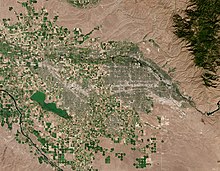
Boise is in southwestern Idaho, about 41 miles (66 km) east of the Oregon border and 110 miles (177 km) north of the Nevada border. The downtown area's elevation is 2,704 feet (824 m) above sea level. Add more here.
Most of the metropolitan area lies on a broad, flat plain, descending to the west. Mountains rise to the northeast, stretching from the far southeastern tip of the Boise city limits to nearby Eagle. These mountains are known to locals as the Boise foothills and are sometimes described as the foothills of the Rocky Mountains. About 34 miles (55 km) southwest of Boise, and about 26 miles (42 km) southwest of Nampa, the Owyhee Mountains lie entirely in neighboring Owyhee County.
According to the United States Census Bureau, the city has an area of 80.05 square miles (207.33 km2), of which 79.36 square miles (205.54 km2) is land and 0.69 square miles (1.79 km2) is water.[1] The city is drained by the Boise River and is considered part of the Treasure Valley.
Important Geographic features[edit]
Type more here.
- ^ "US Gazetteer files 2010". United States Census Bureau. Archived from the original on January 12, 2012. Retrieved December 18, 2012.
