User:Tselechegu
Tselemti
ጸለምቲ (Tigrinya) | |
|---|---|
| File:Serako - Tselemti - Ethiopia.jpg | |
 | |
| Country | |
| Region | northern Ethiopia |
| Zone | Mi'irabawi Zone Mi'irabawi Western)]] |
| Administrative center | Mai Tsebri |
| Area | |
| • Total | 3,858.66 km2 (1,489.84 sq mi) |
| Population (2023) | |
| • Total | 1,278,980 |
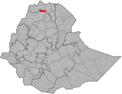
Tselemti (Tigrinya: ጸለምቲ, lit. 'blackish') is an Ethiopian District, or woreda, in the northern Ethiopia of Ethiopia.[1] Part of the Semien Mi'irabawi (North Western) Zone, Tselemti is bordered on the south by the Amhara Region, on the west by the [wolkayt wereda]], on the north by Asigede Tsimbela, on the northeast by Medebay Zana, and on the east by the Maekelay (Central Area) Zone. The Tekezé defines the boundary between Tselemti and tigray ; other rivers in this woreda include the Abteba ,firafira,serenta and ensiya, a tributaries of the Tekezé river. The administrative center of this woreda is Mai Tsebri; other towns in Tselemti include [[Dima, sekota,embamadre,mekabir ambessa,enkoyliham,mayteklit etc.
- ^ C.F. Beckingham and G.W.B. Huntingford, Some records of Ethiopia, 1593-1646 (London: Hakluyt Society, 1954), p. 243. The earliest surviving mention of this area is in the Futuh al-Habasha, written shortly after 1559. (Sihab ad-Din Ahmad bin 'Abd al-Qader, Futuh al-Habasa: The conquest of Ethiopia, translated by Paul Lester Stenhouse with annotations by Richard Pankhurst [Hollywood: Tsehai, 2003], p. 84). Huntingford, George Wynn Brereton. The Historical Geography of Ethiopia: From the First Century Ad to 1704. Oxford: Oxford University Press, 1989.
