User:Sagredo/contributions
Contributions of which I am the most proud[edit]
Polar ice packs- An very important fact, which I think doesn't get brought up nearly often enough.[edit]
The Arctic Sea has not been ice free for a period of at least one million years, and probably much longer.[1][2]
=New Orleans Locals love their city, and do not like anything negative said about it. They will
agressively edit out everything negative, even hard science.=
Geography[edit]
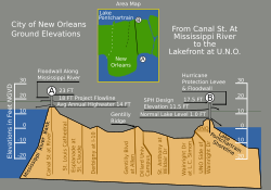
New Orleans was originally settled on the natural high ground along the Mississippi River. But according to a report by the American Society of Civil Engineers "New Orleans is subsiding (sinking)"[3] "Large portions of Orleans, St.Bernard, and Jefferson parishes are currently below sea level — and continue to sink. New Orleans is built on thousands of feet of soft sand, silt, and clay. Subsidence, or settling of the ground surface, occurs naturally due to the consolidation and oxidation of organic soils (called “marsh ” in New Orleans) and local groundwater pumping. In the past, flooding and deposition of sediments from the Mississippi River counterbalanced the natural subsidence, leaving southeast Louisiana at or above sea level. However, due to major flood control structures being built upstream on the Mississippi River and levees being built around New Orleans, fresh layers of sediment are not replenishing the ground lost by subsidence. The natural subsidence has also been exacerbated by groundwater withdrawals, petroleum production, development, and other factors. Based on data collected by the United States Geological Survey from benchmarks located primarily in Orleans Parish (1951-1995), subsidence has been estimated to occur at an average rate of about 0.15 to 0.2 inches per year, although rates in excess of 1 inch per year occur in some locations."[4]

Climate[edit]

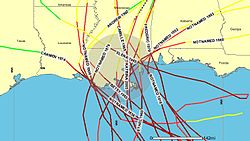
Hurricanes pose a severe threat to the area, and the city is particularly vulnerable because of its low elevation. According the Federal Emergency Management Agency, the city is the most vulnerable in the country when it comes to hurricanes.[5] Since 1965, portions of New Orleans have been flooded by four different storms, Hurricane Betsy, Hurricane Georges, Hurricane Katrina and Hurricane Rita.[6][7] It is likely that we will see increases in hurricane intensity during the 21st century according to the IPCC Fourth Assessment Report[8]
Army Corps of Engineers interactive map showing flood risk
In 2006, after Katrina, New Orleans hosted 3.7 million visitors.[9]
Prior to Katrina, in the Greater New Orleans Area, there were 265 hotels with an inventory of 38,338 rooms.[10]. As of May, 2007 there are over 140 metro area hotels and motels in operation with over 31,000 rooms in inventory.[10]. Sagredo 04:36, 11 October 2007 (UTC)
This page also serves to backup the New Orleans items, so if they are deleted, they can be easily restored.[edit]
- ^ Pew Center on Global Climate Change " Arctic Ice Cap at Record Minimum Size"
- ^ "Arctic System on Trajectory to New, Seasonally Ice-Free State"
- ^ American Society of Civil Engineers.
- ^ American Society of Civil Engineers.
- ^ Federal Emergency Management Agency
- ^ [1]
- ^ "The Weather Channel's Special Report: Vulnerable Cities - New Orleans, LA". Retrieved 2006-10-26.
- ^ IPCC Fourth Assessment Report
- ^ [ Official Site of Greater New Orleans - Retrieved October 10, 2007, from http://www.neworleanscvb.com/faq/index.cfm/action/Cover]
- ^ a b New Orleans Tourism Marketing Corporation
