
User:Rosserlloyd/Sandbox1

The Eglinton Tournament Bridge is situated within Eglinton Country Park which is itself located in the grounds of the old Eglinton Castle estate, Irvine, on the outskirts of Kilwinning, North Ayrshire, Scotland (Map reference: NS 3206 4224). Eglinton Country Park is situated in the parish of Kilwinning, part of the former district of Cunninghame, and covers an area of 400 hectares (988 acres), 175 hectares of which are woodland. The central iconic feature of the country park is the ruined Eglinton Castle, once home to the Eglinton family and later the Montgomerie's, Earls of Eglinton and chiefs of the Clan Montgomery. However another striking feature of the park is the Tournament Bridge over the Lugton Water.
Eglinton Country Park is managed and maintained by North Ayrshire Council and its Ranger Service.
Location[edit]
Eglinton is a one hour drive from Glasgow, accessed via the M77 to Kilmarnock, followed by the A71 to Irvine, and then the A78(T) to Eglinton Junction on the outskirts of Kilwinning. It is a 30 minute walk from Kilwinning town centre along the banks of the River Garnock or by the A737 Irvine - Kilwinning road. A regular bus service also runs by the western entrance to the park.[1]
The Tournament Bridge[edit]
The famous Eglinton Tournament took place in 1839 and to provide a centre piece as well as openning up the far side of the Lugton Water the 13th Earl of Eglinton had a Gothic style cast iron and stone bridge constructed. The iron 'Tournament' bridge was designed by the architect David Hamilton. An older bridge with three arches had seemingly stood further up the river towards the castle as shown in several contemporary prints and maps as illustrated in the appropriate gallery of this article.[2] A small wooden bridge is shown in an illustration dated 1837. The Tournament Bridge is B listed.[3]


Tournament Bridges and castle gallery[edit]
-

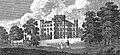
The castle circa 1870. Note the deer grazing in the foreground. -

Eglinton castle. -
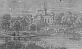
The castle and bridge. Three arches and a lake are illustrated. -
![Eglinton Castle & Bridge. This shows three arches and other differences compared with the surviving bridge.[6] This bridge seems closer to the castle and could be the original bridge which was replaced by the tournament bridge.](//upload.wikimedia.org/wikipedia/commons/thumb/4/48/Eglinton_castle_swan.jpg/120px-Eglinton_castle_swan.jpg)
Eglinton Castle & Bridge. This shows three arches and other differences compared with the surviving bridge.[6] This bridge seems closer to the castle and could be the original bridge which was replaced by the tournament bridge. -

The castle and bridge in 1884. -

The Tournament bridge and castle in 1876. -
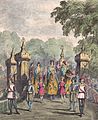
The procession crossing the Tournament Bridge. -
A view of the castle and a wooden footbridge in 1815.

_colour.jpg)

![Eglinton Castle & Bridge. This shows three arches and other differences compared with the surviving bridge.[6] This bridge seems closer to the castle and could be the original bridge which was replaced by the tournament bridge.](/wiki/File:Eglinton_castle_swan.jpg)


The circa 1790 pleasure gardens[edit]


The 18th century ornamental pleasure gardens were established in what became part of the deer park. No signs of these gardens are now visible, apart from Crop marks on aerial photographs taken around the end of the Second World War. A bridge was necessary to give access and one is indicated on John Ainslie's map dated 1790, crossing the Lugton Water close to the castle itself. A small wooden bridge is shown in an illustration from around 1835, however it is not clear if this crossed the Lugton Water itself.
See also[edit]
References[edit]
- ^ "Stagecoach West Scotland - A1 Service". Retrieved 2007-11-05.
- ^ Aitken, Robert (1829). The Parish Atlas of Ayrshire - Cunninghame. Pub. W. Ballantine. Edinburgh.
- ^ Historic gardens
- ^ Dobie, James (1876). Pont's Cuninghame Pub. John Tweed.
- ^ Ness, J. A. (1969 - 70). Landmarks of Kilwynnyng. Privately produced. P. 29.
- ^ Leighton, John M. (1850).Strath Clutha or the Beauties of the Clyde. Pub. Joseph Swan Engraver. Glasgow. Facing p. 229.