User:Phaisit16207/sandbox/Russian conquest of Central Asia
| Russian conquest of Central Asia | |||||||||
|---|---|---|---|---|---|---|---|---|---|
| Part of the territorial evolution of Russia | |||||||||
 Map of Russian conquest of Turkestan | |||||||||
| |||||||||
| Belligerents | |||||||||
|
|
Kazakh Khanate (until 1848) Kokand Khanate (until 1876) Turkmen tribes Kyrgyz tribes | ||||||||
| Commanders and leaders | |||||||||
|
Ormon Khan |
Abu'l-Khair Muhammed Khan Nur Ali Khan Ablai Khan Nauryzbai Batyr † Azizuddin Bahadur † Jar Muhammad Khan Qasim Sultan Wali Sultan Adil Sultan Ğubaidullah Khan † Kenesary Kasymov Sher Ghazi Khan † Syzdyk Sultan Muhammad Mallya Beg Khan Muhammad Sultan Khan Alimqul † Muhammad Khudayar Khan Berdi Murad Khan † Kara Bateer † Makhdum Kuli Khan | ||||||||
| Strength | |||||||||
|
5,000 troops 10,000 camels In 1843: 5,000+ troops In 1853: 2,000+ troops In 1864: 2,500 troops In 1873: 13,000 troops In 1879: 3,500 troops In 1881: 7,100 troops In 1883–1885: 1,500 troops |
In 1844-1845 (Kazakh Khanate): ~12,000 troops In 1865: ~36,000 troops | ||||||||
| Casualties and losses | |||||||||
|
1,054 killed or died of diseases In 1866: 500 killed and wounded In 1879: 200+ killed ~250 wounded In 1881: 59–268 killed 254–669 wounded 645 died of diseases In 1885: 11 killed or wounded |
230+ killed In 1875: thousands killed 12 000 killed In 1868: 3 500+ killed Turkmen tribes: In 1879: 2,000+ killed 2,000+ wounded In 1881: ~8,000 killed (incl. civilians) ~900 killed or wounded | ||||||||
The Russian conquest of Central Asia were a series of conquests that were carried out by the Russian Tsardom and later the Empire from 1714 to 1895, which mainly occured in the area that's what called Turkestan against the predominantly Turkic tribes and many rebel figures who resisted the Russian invasion. Due to the century-long conquest, Russia streched the territory from the Kazakh Steppe to Iran and Afghanistan, with two imperial protectorates of Khiva and Bukhara.
Outline[edit]
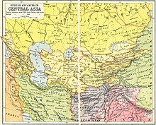
In the eighteenth century the Russian Empire gained increasing control over the Kazakh Steppe. The Russian conquest of Central Asia took place over several decades. In 1839, Russia failed to conquer the Khanate of Khiva south of the Aral Sea. In 1847–53, the Russians built a line of forts from the north side of the Aral Sea eastward up the Syr Darya river. In 1847–64, they crossed the eastern Kazakh Steppe and built a line of forts along the northern border of Kyrgyzstan. In 1864–68, they moved south from Kyrgyzstan, captured Tashkent and Samarkand and dominated the Khanates of Kokand and Bokhara. They now held a triangle whose southern point was 1,600 km (990 mi) south of Siberia and 1,920 km (1,190 mi) southeast of their supply bases on the Volga River. The next step was to turn this triangle into a rectangle by crossing the Caspian Sea. In 1873, the Russians conquered Khiva, and in 1881, they took western Turkmenistan. In 1884, they took the Merv oasis and eastern Turkmenistan. In 1885, further expansion south toward Afghanistan was blocked by the British. In 1893–95, the Russians occupied the high Pamir Mountains in the southeast.
Geography[edit]


White areas are thinly-populated desert.
The three northwest-tending lines are, from south to north, the Kopet Dagh mountains and the Oxus and Jaxartes Rivers flowing from the eastern mountains into the Aral Sea.

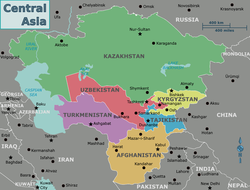
The area was bounded on the west by the Caspian Sea, on the north by the Siberian forests and on the east by the mountains along the former Sino-Soviet border. The southern border was political rather than natural. It was about 2,100 km (1,300 mi) from north to south, 2,400 km (1,500 mi) wide in the north and 1,400 km (900 mi) wide in the south. Because the southeast corner (Kyrgyzstan and Tajikistan) is mountainous the flat desert-steppe country is only about 1,100 km (700 mi) wide in the south. Using modern borders, the area was 4,003,400 km2 (1,545,730 sq mi), about half the size of the United States without Alaska. On the east side two mountain ranges project into the desert. Between them is the well-populated Fergana Valley which is approximately the "notch" on the west side of Kyrgyzstan. North of this projection the mountain-steppe boundary extends along the north border of Kyrgyzstan about 640 km (400 mi) before the mountains turn north again.
Rainfall decreases from north to south. Dense population, and therefore cities and organized states, requires irrigation. Streams coming down from the eastern mountains support a fairly dense population, especially in the Ferghana Valley. There is a line of oases along the Persian border. The interior is watered by three great rivers. The Oxus or Amu Darya rises on the Afghan border and flows northwest into the Aral Sea, forming a large delta which was ruled by the Khanate of Khiva and has a long history under the name of Khwarezm. The Jaxartes or Syr Darya rises in the Ferghana Valley and flows northwest and then west to meet the northeast corner of the Aral Sea. Between them is the less-famous Zarafshan River which dries up before reaching the Oxus. It waters the great cities of Bokhara and Tamerlane's old capital of Samarkand.
The deserts in the south have enough grass to support a thin nomadic population. The Kyzylkum Desert is between the Oxus and Jaxartes. The Karakum Desert is southwest of the Oxus in Turkmenistan. Between the Aral and Caspian Seas is the thinly-populated Ustyurt Plateau.
When the Russians arrived the organized states were the Khanate of Khiva in the Oxus delta south of the Aral Sea, the Khanate of Bukhara along the Oxus and Zarafshan and the Khanate of Kokand based in the Ferghana Valley. Bokhara had borders with the other two and all three were surrounded by nomads which the Khanates tried to control and tax.
Notes[edit]
- ^ Some sources begin the conquest at 1589
