User:Oatco/Saimaa rewrite draft
| Saimaa | |
|---|---|
| |
 Aerial view of a frozen Saimaa. | |
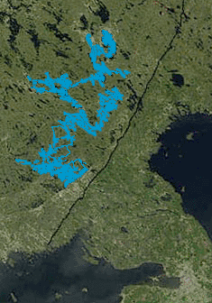
 Location and extent of Saimaa highlighted in a satellite photo. The black line is the Finnish-Russian border. | |
| Location | Southeastern Finland |
| Coordinates | 61°52′N 028°52′E / 61.867°N 28.867°E |
| Type | Glacial lake |
| Primary outflows | Vuoksi River, Saimaa Canal |
| Basin countries | Finland, Russia |
| Max. length | 180 km (110 mi) |
| Max. width | 140 km (87 mi) |
| Surface area | 4,279 km2 (1,652 sq mi) |
| Max. depth | 86 m (282 ft) |
| Water volume | 54 km3 (44,000,000 acre⋅ft) |
| Shore length1 | 14,850 km (9,230 mi) |
| Surface elevation | 76 m (249 ft) |
| Islands | 13,710 |
| Settlements | Lappeenranta, Imatra, Savonlinna, Mikkeli, Joensuu |
| 1 Shore length is not a well-defined measure. | |
Saimaa (/ˈsaɪmɑː/ SY-mah, Finnish pronunciation: [ˈsɑi̯mɑː]; Swedish: Saimen), or Greater Saimaa, is the largest lake in Finland, located in the southeast of the country, in the Finnish lakeland, lying between the cities of Lappeenranta and Joensuu. With a length of 180 kilometres (110 mi) and an area of 4,279 square kilometres (1,652 sq mi),[1][2] it is also the fourth-largest natural freshwater lake in Europe, behind only the nearby Russian lakes of Ladoga and Onega and the Swedish lake Vänern. Saimaa is formed by a number of large open basins connected by a labyrinthine network of straits, and contains some 13,710 islands, of which the largest (Soisalo and Sääminginsalo) are larger than the basins they are in. The lake's waters drain into the river Vuoksi at Imatra, which then flows into Lake Ladoga; it is also accessible from the Gulf of Finland via the Saimaa Canal.
Like most of Finland's hydrology, Saimaa is very recent on a geological timescale: the basins and straits that form it were formed during the last ice age. During the initial stages of post-glacial rebound the lake was directly connected to what would become the Baltic Sea; as the glaciers retreated, sea levels fell and land levels rose, and Saimaa, along with the rest of the Finish lakeland, was separated from the sea around 9000 years ago. At this time a Baltic species of seal became trapped in the lake, evolving into the now-critically-endangered Saimaa ringed seal, which is the only mammal that only appears in Finland.
Hydrography[edit]
Geology[edit]
Natural history[edit]
History[edit]
Economy[edit]
Transport[edit]
References[edit]
- ^ "Suur-Saimaa". Järvi-meriwiki (in Finnish). Finnish Environment Institute. 9 March 2021. Retrieved 23 February 2023.
[Suur-Saimaan] yhteenlaskettu pinta-ala on 427 946,4 ha ja suurin syvyys 85,81 m.
[The total surface area [of Suur-Saimaa] is 427,946.4 hectares and its greatest depth is 85.81 meters.] - ^ Kuusisto, Esko, ed. (1999). Saimaa: a Living Lake. Translated by Hicks, Malcolm. Helsinki, Finland: Tammi Publishers. ISBN 951-31-1667-0.

