
User:N.sprang/sandbox
Main Project[edit]
Looking at the things that WikiEdu for asked I will try to do the following:
     -add information about where the water in the reservoir comes from and goes to
     -add information about the trails
     -I will take more pictures to add to the Wikipedia page as requested.
sources are hard to find and EDMUD itself was not willing to help me because they "do not update their social media" as a representative told me.
-this document includes information about the infrastructure that supplies Briones with water.
Bay Nature. Apr-Jun2014, Vol. 14 Issue 2, p16-16. 1/3p.
-writes about Bear Creek and how it is dammed by Briones
| Briones Reservoir | |
|---|---|
 | |
| Location | Contra Costa County, California |
| Coordinates | 37°54′54″N 122°12′18″W / 37.915°N 122.205°W |
| Lake type | Reservoir |
| Primary outflows | Terminal (evaporation) |
| Catchment area | 22 km2 (8.5 sq mi) |
| Basin countries | United States |
| Water volume | 60,510 acre⋅ft (74,640,000 m3) |
| References | [1] |

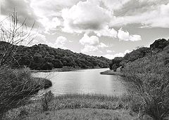
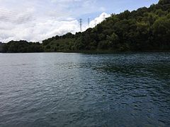
Briones Reservoir is an open cut terminal water storage reservoir owned and operated by the East Bay Municipal Utility District (EBMUD). It is located in the hills northeast of Orinda, California. It is formed by Briones Dam, an earthen dam completed in 1964.[2] The reservoir is the largest of EBMUD’s five East Bay terminal reservoirs with a total capacity of 60,510 acre⋅ft (74,640,000 m3), and it has a total watershed of 8.59 square miles (22 km²).
Water Source[edit]
The Briones Reservoir has two sources for its water. Its watershed of 22km² which includes Bear Creek. Bear Creek once ran down the valley where the reservoir is currently located and still enters the lake in its most Eastern point.[3] Another major, and more important, water source for the Briones Reservoir is imports from the Briones Diversion Works near Orinda through the Briones Aqueduct. This Aqueduct is a 7-foot, 6-inch steel pipe, operated by four pumps that can deliver up to 60 million gallons a day.[4] This is water that originates from EDMUD’s biggest water source: the Mokelumne River. Water drains out of the Briones Reservoir into the San Pablo Reservoir, which is located just in the lower part of the valley. From here, the water is taken into a pumping plant in Kensington.
Recreation[edit]
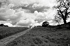
Because the water in the reservoir is mainly for urban use, EBMUD is very strict about recreational activities. Fishing, swimming and wading are not allowed. However, college rowing teams from Mills College, UC Berkeley and Saint Mary's College have permission to use the lake under certain rules. For example, all boats have to be inspected before they are allowed to be used on the lake to prevent contamination. Two trails, the Bear Creek trail and the Oursan trail, form together a 14 mile (23 km) hiking trail that circumnavigates the reservoir. The hike begins at the Bear Creek Staging Area, which is part of Briones Regional Park[5]. A Trail Use Permit issued by EBMUD is required by all hikers, which can be obtained online at the EBMUD website for 10 dollars. No biking is permitted on the trail. Horseback riding is allowed. Dogs are allowed on Oursan Trail segment only and must be leashed.
Photos[edit]
- Briones reservoir area
-

-
-

-

-

-

-
-
-

-


See also[edit]
- List of dams and reservoirs in California
- List of lakes in California
- List of lakes in the San Francisco Bay Area
References[edit]
- ^ U.S. Geological Survey Geographic Names Information System: N.sprang/sandbox
- ^ "Dams Within the Jurisdiction of the State of California (A-G)" (PDF). California Department of Water Resources, Division of Safety of Dams. Retrieved November 1, 2012.
- ^ ite Bay Nature. Apr-Jun2014, Vol. 14 Issue 2, p16-16. 1/3p.
- ^ EAST BAY MUNICIPAL UTILITY DISTRICT WATER SYSTEM REVENUE REFUNDING BONDS, SERIES 2012B https://www.ebmud.com/sites/default/files/pdfs/water-system-revenue-refunding-bonds-series-2009a_2.pdf
- ^ http://www.redwoodhikes.com/EastBay/BrionesReservoir.html
External links[edit]
- EBMUD Web Site
- "EBMUD Trail Map" (PDF). (842 KiB)
- Purchase EBMUD Trail Use Permit Online
- Briones Reservoir on Redwood Hikes
Category:East Bay Municipal Utility District Category:Reservoirs in Contra Costa County, California Category:Dams in California Category:United States local public utility dams Category:Dams completed in 1964 Category:Reservoirs in California
This Contra Costa County, California–related article is a stub. You can help Wikipedia by expanding it. |
 | This is a user sandbox of N.sprang. A user sandbox is a subpage of the user's user page. It serves as a testing spot and page development space for the user and is not an encyclopedia article. |