
User:Lithistman/Dodge City, Kansas
Dodge City, Kansas | |
|---|---|
| Nickname(s): "The Cowboy Capital of The World"; "The Wicked Little City"; "Queen of the Cowtowns"; "Bibulous Babylon of the Frontier" | |
 Location of Dodge City in Kansas | |
 Map of Dodge City | |
| Coordinates: 37°45′35″N 100°01′06″W / 37.75972°N 100.01833°W | |
| Country | United States |
| State | Kansas |
| County | Ford |
| Founded | 1872 |
| Government | |
| • Mayor | E. Kent Smoll |
| Area | |
| • Total | 12.7 sq mi (33 km2) |
| • Land | 12.6 sq mi (33 km2) |
| • Water | 0.1 sq mi (0.3 km2) |
| Elevation | 2,493 ft (760 m) |
| Population | |
| • Total | 27,340 |
| • Density | 2,200/sq mi (830/km2) |
| Time zone | UTC-6 (Central (CST)) |
| • Summer (DST) | UTC-5 (CDT) |
| ZIP code | 67801, 67843 |
| Area code | 620 |
| GNIS feature ID | 485363[2] |
| Website | www.DodgeCity.org |
Dodge City, Kansas is a United States city which lies within, and is the county seat of, Ford County, Kansas. Named after nearby Fort Dodge, the city is famous in American culture for its history as a wild frontier town of the Old West.[3][4][5] As of the 2010 census, the city population was 27,340.[1]
History[edit]
Origins[edit]

The first settlement of non-indigenous people in the area that became Dodge City was Fort Mann. Built by civilians in 1847, Fort Mann was intended to provide protection for travelers on the Santa Fe Trail. Fort Mann collapsed in 1848 after an Indian attack. In 1850, the U.S. Army arrived to provide protection in the region and constructed Fort Atkinson on the old Fort Mann site. The army abandoned Fort Atkinson in 1853. Military forces on the Santa Fe Trail were reestablished farther north and east at Fort Larned in 1859, but the area around what would become Dodge City remained vacant until after the Civil War. In 1865, as the Indian Wars in the West began heating up, the army constructed Fort Dodge to assist Fort Larned in providing protection on the Santa Fe Trail. Fort Dodge remained in operation until 1882.
The town of Dodge City can trace its origins to 1871 when rancher Henry J. Sitler built a sod house west of Fort Dodge to oversee his cattle operations in the region. Conveniently located near the Santa Fe Trail and Arkansas River, Sitler's house quickly became a stopping point for travelers. With the Santa Fe Railroad rapidly approaching from the east, others saw the commercial potential of the region. In 1872, just five miles (8 km) west of Fort Dodge, settlers platted out and founded the town of Dodge City. George M. Hoover established the first bar in a tent to service thirsty soldiers from Fort Dodge. The railroad arrived in September to find a town ready and waiting for business. The early settlers in Dodge City traded in buffalo bones and hides and provided a civilian community for Fort Dodge. However, with the arrival of the railroad, Dodge City soon became involved in the cattle trade.
Cattle trade[edit]

The idea of driving Texas longhorn cattle from Texas to railheads in Kansas originated in the late 1850s[citation needed] but was cut short by the Civil War. In 1866, the first Texas cattle started arriving in Baxter Springs in southeastern Kansas by way of the Shawnee Trail. However, Texas longhorn cattle carried a tick that spread splenic fever, known locally as Texas Fever, among other breeds of cattle. Alarmed Kansas farmers persuaded the Kansas State Legislature to establish a quarantine line in central Kansas. The quarantine prohibited Texas longhorns from the heavily settled, eastern portion of the state.
With the cattle trade forced west, Texas longhorns began moving north along the Chisholm Trail. In 1867, the main Cow Town was Abilene, Kansas. Profits were high, and other towns quickly joined in the cattle boom. Newton in 1871; Ellsworth in 1872; and Wichita in 1872. However, in 1876 the Kansas State Legislature responded to pressure from farmers settling in central Kansas and once again shifted the quarantine line westward, which essentially eliminated Abilene and the other Cow Towns from the cattle trade. With no place else to go, Dodge City suddenly became Queen of the Cow Towns.
A new route, known as the Great Western Cattle Trail, or Western Trail, branched off from the Chisholm Trail to lead cattle into Dodge City. Dodge City became a boomtown, with thousands of cattle passing annually through its stockyards. The peak years of the cattle trade in Dodge City were from 1883 to 1884, and during that time the town grew tremendously. In 1880, Dodge City got a new competitor for the cattle trade from the border town of Caldwell. For a few years the competition between the towns was fierce, but there were enough cattle for both towns to prosper. Nevertheless, it was Dodge City that became famous, and rightly so because no town could match Dodge City's reputation as a true frontier settlement of the Old West. Dodge City had more famous (and infamous) gunfighters working at one time or another than any other town in the West, many of whom participated in the Dodge City War of 1883. It also boasted the usual array of saloons, gambling halls, and brothels established to separate a lonely cowboy from his hard-earned cash, including the famous Long Branch Saloon and China Doll brothel. For a time in 1884, Dodge City even had a bullfighting ring where Mexican bullfighters imported from Mexico would put on a show with specially chosen longhorn bulls.
As more agricultural settlers moved into western Kansas, pressure on the Kansas State Legislature to do something about splenic fever increased. Consequently, in 1885 the quarantine line was extended across the state and the Western Trail was all but shut down. By 1886, the cowboys, saloon keepers, gamblers, and brothel owners moved west to greener pastures, and Dodge City became a sleepy little town much like other communities in western Kansas.
Geography[edit]

Dodge City is located at 37°45′35″N 100°1′6″W / 37.75972°N 100.01833°W (37.759671, -100.018212) at an elevation of 2,493 feet (760 m).[2][7] It lies on the Arkansas River in the High Plains region of the Great Plains. The city sits above one of the world’s largest underground water systems, the Ogallala Aquifer, and is only 25 miles (40 km) from the eastern edge of the Hugoton Natural Gas Area. Located at the intersection of U.S. Route 50, U.S. Route 56, and U.S. Route 283 in southwestern Kansas, Dodge City is approximately 151 miles (244 km) west of Wichita, 199 miles (320 km) northeast of Amarillo, and 301 miles (484 km) southeast of Denver.[8]
According to the United States Census Bureau, the city has a total area of 12.7 square miles (32.9 km²), of which 12.6 square miles (32.7 km²) is land and 0.1 square miles (0.3 km²) (0.86%) is water.
Climate[edit]
Dodge City lies in North America's temperate semi-arid climate zone (Köppen BSk) with hot summers, highly variable winters with both warm and very cold periods, and low to moderate humidity and precipitation throughout the year. The yearly average temperature is 55 °F (12 °C) with temperatures exceeding 90 °F (32 °C) an average of 64 days a year and dropping below 32 °F (0 °C) an average of 125 days a year.[9] On average, the city receives 22 inches (568 mm) of precipitation annually and experiences 79 rainy days a year. Snowfall averages 22 inches (55 cm) per year.[10] Dodge City is often cited as the windiest city in the United States with an average speed of 13.9 mph (22.4 km/h), which results in occasional blizzards in the winter, even when snowfall is light.[11] Severe weather, including tornadoes, is common in the area, especially in the spring months. On average, January is the coolest month and July is both the warmest and wettest month. The hottest temperature recorded in Dodge City was 110 °F (43 °C) in 1998; the coldest temperature recorded was -26 °F (-32 °C) in 1899.[12]
| Climate data for Dodge City, Kansas, USA | |||||||||||||
|---|---|---|---|---|---|---|---|---|---|---|---|---|---|
| Month | Jan | Feb | Mar | Apr | May | Jun | Jul | Aug | Sep | Oct | Nov | Dec | Year |
| Record high °F (°C) | 80 (27) |
86 (30) |
98 (37) |
100 (38) |
105 (41) |
110 (43) |
109 (43) |
109 (43) |
106 (41) |
98 (37) |
91 (33) |
86 (30) |
110 (43) |
| Mean daily maximum °F (°C) | 41 (5) |
48 (9) |
57 (14) |
67 (19) |
76 (24) |
87 (31) |
93 (34) |
91 (33) |
82 (28) |
70 (21) |
55 (13) |
44 (7) |
68 (20) |
| Daily mean °F (°C) | 30 (−1) |
36 (2) |
44 (7) |
54 (12) |
64 (18) |
74 (23) |
80 (27) |
78 (26) |
69 (21) |
57 (14) |
42 (6) |
33 (1) |
55 (13) |
| Mean daily minimum °F (°C) | 19 (−7) |
24 (−4) |
31 (−1) |
41 (5) |
52 (11) |
62 (17) |
67 (19) |
66 (19) |
57 (14) |
44 (7) |
30 (−1) |
22 (−6) |
43 (6) |
| Record low °F (°C) | −20 (−29) |
−26 (−32) |
−15 (−26) |
9 (−13) |
19 (−7) |
36 (2) |
46 (8) |
43 (6) |
29 (−2) |
10 (−12) |
−13 (−25) |
−21 (−29) |
−26 (−32) |
| Average precipitation inches (mm) | 0.62 (16) |
0.66 (17) |
1.84 (47) |
2.25 (57) |
3.00 (76) |
3.15 (80) |
3.17 (81) |
2.73 (69) |
1.70 (43) |
1.45 (37) |
1.01 (26) |
0.77 (20) |
22.35 (568) |
| Average snowfall inches (cm) | 5.2 (13) |
4.3 (11) |
5.0 (13) |
0.9 (2.3) |
0 (0) |
0 (0) |
0 (0) |
0 (0) |
0 (0) |
0.5 (1.3) |
1.9 (4.8) |
3.7 (9.4) |
21.5 (54.8) |
| Average precipitation days (≥ 0.01 in) | 4.7 | 4.5 | 7.3 | 7.3 | 9.8 | 8.7 | 8.4 | 7.8 | 5.9 | 5.5 | 4.9 | 4.6 | 79.4 |
| Average snowy days (≥ 0.1 in) | 4.3 | 2.8 | 2.7 | 0.7 | 0.1 | 0 | 0 | 0 | 0 | 0.3 | 1.4 | 2.9 | 15.2 |
| Source: The Weather Channel;[12] National Weather Service[10] | |||||||||||||
Demographics[edit]
| Census | Pop. | Note | %± |
|---|---|---|---|
| 1880 | 996 | — | |
| 1890 | 1,763 | 77.0% | |
| 1900 | 1,942 | 10.2% | |
| 1910 | 3,214 | 65.5% | |
| 1920 | 5,061 | 57.5% | |
| 1930 | 10,059 | 98.8% | |
| 1940 | 8,487 | −15.6% | |
| 1950 | 11,262 | 32.7% | |
| 1960 | 13,520 | 20.0% | |
| 1970 | 14,127 | 4.5% | |
| 1980 | 18,001 | 27.4% | |
| 1990 | 21,129 | 17.4% | |
| 2000 | 25,176 | 19.2% | |
| 2010 | 27,340 | 8.6% | |
As of the census of 2000, there were 25,176 people, 8,395 households, and 5,968 families residing in the city. The population density was 1,995.8 people per square mile (770.9/km²). There were 8,976 housing units at an average density of 711.6 per square mile (274.8/km²). The racial makeup of the city was 71.43% White, 1.94% African American, 0.69% Native American, 2.37% Asian, 0.15% Pacific Islander, 20.82% from other races, and 2.61% from two or more races. Hispanic or Latino of any race were 42.87% of the population.
There were 8,395 households out of which 41.1% had children under the age of 18 living with them, 55.1% were married couples living together, 10.3% had a female householder with no husband present, and 28.9% were non-families. 23.5% of all households were made up of individuals and 9.6% had someone living alone who was 65 years of age or older. The average household size was 2.94 and the average family size was 3.46.
In the city the population was spread out with 31.2% under the age of 18, 12.3% from 18 to 24, 30.0% from 25 to 44, 16.5% from 45 to 64, and 10.0% who were 65 years of age or older. The median age was 29 years. For every 100 females there were 106.7 males. For every 100 females age 18 and over, there were 104.2 males.
The median income for a household in the city was $37,156, and the median income for a family was $41,672. Males had a median income of $26,881 versus $22,064 for females. The per capita income for the city was $15,538. About 11.1% of families and 13.9% of the population were below the poverty line, including 17.4% of those under age 18 and 9.1% of those age 65 or over.[13]
Economy[edit]

Meat packing is the primary industry in Dodge City. Cargill Meat Solutions and National Beef are the two largest employers with roughly 2,700 employees each.[14] The city also hosts farm implement manufacturing and serves as a supply center for area agriculture. Livestock-raising is a major activity while wheat and sorghum are the area's main crops.[5] In addition, a local tourism industry, including a casino resort, has developed to capitalize on Dodge City's history as an Old West cowtown.[15] The service sector accounts for much of the rest of the local economy with local government, schools, retail stores, and health care providers as the city's other major employers.[14]
Government[edit]
Dodge City has a commission-manager form of government with a city commission consisting of five members. The commissioners serve either two-year or four-year terms depending on the number of votes they receive. Every year, the commission selects one commissioner to serve as mayor and another to serve as vice-mayor.[16] Appointed by the commission, the city manager leads the city administration, executes the commission's policies, and develops operational programs to meet the city's needs.[17]
Education[edit]
Colleges and universities[edit]
Primary and secondary education[edit]
Dodge City Public Schools (Unified School District 443) operates fourteen schools in the city:[18]
|
|
|
There is also one Catholic school in Dodge City: Sacred Heart Cathedral School (K-8).[19]
Transportation[edit]
Four U.S. Highways meet in Dodge City: U.S. Route 50, U.S. Route 56, U.S. Route 283, and U.S. Route 400. U.S. 50, an east-west route, runs through the northern part of the city. U.S. 400, which also runs east-west, runs through the southern part of the city. U.S. 56, an east-west route, and U.S. 283, a north-south route, run concurrently around the city's southern and eastern fringe. A U.S. 50 business route runs concurrently with U.S. 56, U.S. 283, and U.S. 400 at different points through the southern part and around the eastern part of the city.
Dodge City Regional Airport is located approximately 2 miles (3 km) east of the city. Used primarily for general aviation, it hosts one commercial airline under the Essential Air Service program.
Three railroads serve Dodge City: the La Junta Subdivision of the BNSF Railway, which runs east-west, the main line of the Cimarron Valley Railroad, of which Dodge City is the northeastern terminus, and the Boot Hill & Western Railway, of which the city is the northwestern terminus.[20] Amtrak uses the La Junta Subdivision to provide passenger rail service; Dodge City is a stop on the Southwest Chief line.
Media[edit]
Print[edit]
Newspapers
- The Dodge City Daily Globe, daily[21]
- The High Plains Journal, weekly[22]
- The Southwest Kansas Register, weekly, published by the Roman Catholic Diocese of Dodge City[23]
Radio[edit]
The following radio stations are licensed to and/or broadcast from Dodge City:
AM
| Frequency | Callsign[24] | Format[25] | City of License | Notes |
|---|---|---|---|---|
| 1370 | KGNO | Talk | Dodge City, Kansas | - |
| 1550 | KDCC | Variety | Dodge City, Kansas | DCCC college radio[26] |
FM
| Frequency | Callsign[27] | Format[28] | City of License | Notes |
|---|---|---|---|---|
| 89.9 | KAIG | Christian Contemporary | Dodge City, Kansas | Air 1[29] |
| 91.9 | KONQ | Variety | Dodge City, Kansas | DCCC college radio[26] |
| 92.9 | KMML | Regional Mexican | Cimarron, Kansas | Broadcasts from Dodge City[30] |
| 93.9 | KZRD | Rock | Dodge City, Kansas | - |
| 95.5 | KAHE | Oldies | Dodge City, Kansas | - |
| 96.3 | KERP | Country | Ingalls, Kansas | Broadcasts from Dodge City[31] |
| 102.1 | KODC-LP | Religious | Dodge City, Kansas | - |
Television[edit]
Dodge City is in the Wichita-Hutchinson, Kansas television market.[32] The following television stations are licensed to and/or broadcast from Dodge City:
| Digital Channel | Digital Subchannel | Analog Channel | Callsign[33] | Network | City of License | Notes |
|---|---|---|---|---|---|---|
| 6 | 6.1 | - | KBSD-DT | CBS | Ensign, Kansas | Broadcasts from Dodge City; Satellite of KWCH-DT, Wichita, Kansas[34] |
| 21 | 21.1 | - | KDCK | PBS (SD) | Dodge City, Kansas | Satellite of KOOD, Bunker Hill, Kansas[35] |
| 21.2 | PBS (HD) | |||||
| 21.3 | Create | |||||
| 21.4 | PBS World | |||||
| - | - | 29 | KSAS-LP | FOX | Dodge City, Kansas | Translator of KSAS-TV, Wichita, Kansas[36] |
Culture[edit]
Points of interest[edit]

Santa Fe Trail Remains (also known as Santa Fe Trail Ruts), located nine miles (14 km) west of Dodge City on US 50, is a two-mile (3 km) section of the former 1,200-mile (1,900 km) long Santa Fe Trail that is the "longest continuous stretch of clearly defined Santa Fe Trail rut remains in Kansas." It was declared a National Historic Landmark in 1963. There are other sections of Santa Fe Trail ruts that are listed on the National Register of Historic Places. The 19th century buildings of historic Front Street were demolished in an "urban renewal" project in 1970.
Sports[edit]
From 1970 to 1980, the annual Boot Hill Bowl post-season college football game was played in Dodge City. The bowl was sanctioned by the National Association of Intercollegiate Athletics and featured schools such as Washburn University and Emporia State University. The last game was played on November 21, 1980.[37]
In popular culture[edit]
- The Long Branch Variety Show presented at the Long Branch Saloon at Boot Hill Museum recreates entertainment of the cattle-town days of the 1870s and features Miss Kitty of Gunsmoke fame as the headliner in the saloon.
- One of the downtown streets in present-day Dodge City is called Gunsmoke Street, so named because of Dodge City's serving as the setting of the long-running television western Gunsmoke.
- Dodge City is featured in the multi-platform game Gun.
Notable people[edit]
Gallery[edit]
-
Cattle Drive Monument
-
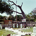 Hanging Tree at Museum
 -
 Graves at Museum
.jpg)

See also[edit]
References[edit]
- ^ a b "2010 City Population and Housing Occupancy Status". United States Census Bureau. Retrieved 2011-03-06.
- ^ a b "US Board on Geographic Names". United States Geological Survey. 2007-10-25. Retrieved 2008-01-31.
- ^ Wright, Robert M. Dodge City, The Cowboy Capital, 1913.
- ^ Schmidt, Heinie, "Fort Dodge State Soldiers' Home", High Plains Journal, January 15, 1948.
- ^ a b "Dodge City". Encyclopædia Britannica. Retrieved 2010-05-08.
- ^ "Will Soule: Scalped Hunter Near Fort Dodge, Kansas". The American Museum of Photography. Retrieved 2010-05-08.
- ^ "US Gazetteer files: 2010, 2000, and 1990". United States Census Bureau. 2011-02-12. Retrieved 2011-04-23.
- ^ "City Distance Tool". Geobytes. Retrieved 2010-05-08.
- ^ "Historical Weather for Dodge City, Kansas, United States of America". Weatherbase. Retrieved 2010-05-08.
- ^ a b "NOWData - NOAA Online Weather Data". National Weather Service Forecast Office - Dodge City, KS. Retrieved 2011-05-04.
- ^ "Wind - Average Wind Speed (MPH)". National Climatic Data Center. Retrieved 2010-05-09.; http://www.ksre.ksu.edu/news/sty/2006/windy_Kansas013006.htm, accessed 19 May 2011
- ^ a b "Average weather for Dodge City, KS". The Weather Channel. Retrieved 2010-05-08.
- ^ "American FactFinder". United States Census Bureau. Retrieved 2008-01-31.
- ^ a b "Major Employers". Dodge City Development Corporation. Retrieved 2010-06-19.
- ^ "Attractions". Dodge City Convention & Visitors Bureau. Retrieved 2010-06-19.
- ^ "Dodge City Commission". City of Dodge City, Kansas. Retrieved 2010-06-19.
- ^ "City Manager's Office". City of Dodge City, Kansas. Retrieved 2010-06-19.
- ^ "Schools". Dodge City Public Schools. Retrieved 2010-06-19.
- ^ "Sacred Heart Cathedral School, Dodge City". Roman Catholic Diocese of Dodge City. Retrieved 2010-06-19.
- ^ "Kansas Operating Division" (PDF). BNSF Railway. 2005-01-01. Retrieved 2010-05-09.
- ^ "About this Newspaper: The Dodge City daily globe". Chronicling America. Library of Congress. Retrieved 2009-09-27.
- ^ "About this Newspaper: The High Plains journal". Chronicling America. Library of Congress. Retrieved 2009-09-27.
- ^ "About this Newspaper: The Southwest Kansas register". Chronicling America. Library of Congress. Retrieved 2009-09-27.
- ^ "AMQ AM Radio Database Query". Federal Communications Commission. Retrieved 2009-09-27.
- ^ "Station Information Profile". Arbitron. Retrieved 2009-09-27.
- ^ a b "DCCC Radio and TV". Dodge City Community College. Retrieved 2011-05-30.
- ^ "FMQ FM Radio Database Query". Federal Communications Commission. Retrieved 2009-09-27.
- ^ "Radio Stations in Dodge City, Kansas". Radio-Locator. Retrieved 2011-05-30.
- ^ "Air 1 Stations". Air 1. Retrieved 2011-05-30.
- ^ "KMML". Rocking M Radio. Retrieved 2011-05-30.
- ^ "KERP". Rocking M Radio. Retrieved 2011-05-30.
- ^ "TV Market Maps". EchoStar Knowledge Base. Retrieved 2011-05-28.
- ^ "TVQ TV Database Query". Federal Communications Commission. Retrieved 2009-09-27.
- ^ "About Us". KWCH-DT. Retrieved 2011-05-28.
- ^ "History". Smoky Hills Public Television. Retrieved 2011-05-27.
- ^ "KSAS Coverage Map" (PDF). KSAS-TV. Retrieved 2011-05-28.
- ^ Games
Further reading[edit]
- Dykstra, Robert R. The Cattle Towns. Lincoln: University of Nebraska Press, 1968. ISBN 0-8032-6561-1
- Miner, Craig. West of Wichita: Settling the High Plains of Kansas, 1865-1890. Lawrence: University Press of Kansas, 1988. ISBN 0-7006-0364-6
- Vestal, Stanley. Dodge City: Queen of Cowtowns: "the Wickedest Little City in America" 1872-1886. Lincoln: University of Nebraska Press, 1998. ISBN 0-8032-9617-7
- Kansas
- The Story of the Marking of the Santa Fe Trail by the Daughters of the American Revolution in Kansas and the State of Kansas; Almira Cordry; Crane Co; 164 pages; 1915.
- History of the State of Kansas; William G. Cutler; A.T. Andreas Publisher; 1883. (Online HTML eBook)
- Kansas : A Cyclopedia of State History, Embracing Events, Institutions, Industries, Counties, Cities, Towns, Prominent Persons, Etc; 3 Volumes; Frank W. Blackmar; Standard Publishing Co; 944 / 955 / 824 pages; 1912. (Volume1 - Download 54MB PDF eBook),(Volume2 - Download 53MB PDF eBook), (Volume3 - Download 33MB PDF eBook)
External links[edit]
- City of Dodge City
- Dodge City Forum
- General Grenville Dodge History
- Dodge City History
- Ft. Dodge History Ford County Historical Society
- Santa Fe Trail Research
- St. Mary of the Plains Academy, High School and College Alumni Association
- Boot Hill Museum
- Coronado Cross
- Fort Larned Historic Site
- Dodge City video-YouTube
Municipalities and communities of Ford County, Kansas, United States | ||
|---|---|---|
| Cities |  | |
| Unincorporated communities | ||
| Townships | ||
| Footnotes | †This community is designated a Census-Designated Place (CDP) by the United States Census Bureau. | |