User:Limkopi/sandbox
Colony of Singapore | |||||||||||||
|---|---|---|---|---|---|---|---|---|---|---|---|---|---|
| 1946–1963 | |||||||||||||
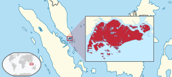
 Location of Singapore in the Malay Archipelago | |||||||||||||
| Status | Colony of the United Kingdom | ||||||||||||
| Capital | Singapore | ||||||||||||
| Common languages | |||||||||||||
| Government |
| ||||||||||||
| King | |||||||||||||
• 1936 - 1952 | George VI | ||||||||||||
• 1952 - present | Elizabeth II | ||||||||||||
| Governor | |||||||||||||
• 1946 - 1952 (first) | Franklin Charles Gimson | ||||||||||||
• 1957 - 1959 (last) | William Goode | ||||||||||||
| Historical era | British Empire | ||||||||||||
• Dissolution of the Straits Settlements | 1 April 1946 | ||||||||||||
• Autonomy under Britain | 1959 | ||||||||||||
• Merger with Federation of Malaysia | 16 September 1963 | ||||||||||||
| Currency |
| ||||||||||||
| ISO 3166 code | SG | ||||||||||||
| |||||||||||||
| Today part of | |||||||||||||
The Colony of Singapore Singapore was a part of the crown colony of the Straits Settlements from 1867 until 1946. From 1946 until 1957 Singapore was a crown colony itself. It was granted self government in 1957 and became an autonomous state in 1959.
with the Cocos (Keeling) Islands and Christmas Island made dependencies of Singapore.
The Province of Upper Canada (French: province du Haut-Canada) was a part of British Canada established in 1791 by the United Kingdom to govern the central third of the lands in British North America and to accommodate Loyalist refugees from the United States of America after the American Revolution. The new province remained the government of the colonial territory for the next fifty years of growth and settlement.
Upper Canada existed from December 26, 1791 to February 10, 1841 and generally comprised present-day Southern Ontario. The prefix "upper" in its name reflects its geographic position higher up the river basin or closer to the headwaters of the Saint Lawrence River than that of Lower Canada or present-day Quebec to the northeast.
Upper Canada included all of modern-day southern Ontario and all those areas of northern Ontario in the Pays d'en Haut which had formed part of New France, essentially the watersheds of the Ottawa River, Lake Huron, and Lake Superior. It did not include any lands within the watershed of Hudson Bay.
The Federation of Rhodesia and Nyasaland, also known as the Central African Federation (CAF), was a semi-independent state in southern Africa that existed from 1953 to the end of 1963, comprising the former self-governing colony of Southern Rhodesia and the British protectorates of Northern Rhodesia and Nyasaland. It was a federal realm of the British Crown – neither a colony nor a dominion, although the British Sovereign was represented by a governor general, as usual for dominions. It was intended eventually to become a dominion in the Commonwealth of Nations.
The Federation was established on 1 August 1953, with the aim of forging a middle way between a fully independent majority-ruled state and the white-dominated territories of South Africa, Angola, and Mozambique.[dubious ] It was intended to be a permanent entity, but ultimately crumbled because the black African nationalists wanted a greater share of power than the dominant minority white population was willing to concede.
The rulers of the new black African states were united in wanting to end colonialism in Africa. With most of the world moving away from colonialism during this time (late 1950s – early 1960s), the United Kingdom was subjected to pressure to de-colonize from both the United Nations and the Organization of African Unity. These groups supported the aspirations of the black African nationalists and accepted their claims to speak on behalf of the people.
The federation officially ended on 31 December 1963. During 1964, Northern Rhodesia gained independence from the UK as the new nation of Zambia and Nyasaland gained independence as the new nation of Malawi. Southern Rhodesia became known as Rhodesia and has been Zimbabwe since 1980.
History[edit]
On 1 April 1946, the Straits Settlements was dissolved and Singapore became a Crown Colony with a civil administration headed by a Governor and separated from peninsular Malaya. In July 1947, separate Executive and Legislative Councils were established and provisions were made to allow for the election of six members of the Legislative Council the next year.[1]
| History of Singapore |
|---|
 |
|
|
See also[edit]
Bibliography[edit]
References[edit]
- ^ "Towards Self-government". Ministry of Information, Communications and the Arts, Singapore. Retrieved 18 June 2006.


