
User:IveGoneAway/Rock DXing
Rock DXing is the hobby of collecting and identifying distant-sourced rock or mineral samples from local deposits. Many rock DXers also attempt to document verifications of source formations and exposure locations. The name of the hobby comes from DX, telegraphic shorthand for "distance" or "distant".[1]
Note: Just getting started. I will also be adding pictures of my collection over time it, so watch if interested.
Where I DX from[edit]
My rock DXing area is primarily the upper Kansas River between the Big Blue and the Republican, but I also pick up some from locations as far west as Hays and east as Kansas City.
River gravel types and sources[edit]
Very common along the Kansas River is landscaping gravel dredged from the river, and much of this gravel has come a very long distance for me to look at. Obviously, limestone is common, but the grinding that goes on in the river selects for hard, mineralized rocks:
- brown Carboniferous cherts from Utah (ISYN, see below (eventually)),
- quartzites and pegmatics from the Rocky Mountains,
- Permian cherts from the Colorado Front Range,
- silcretes from the High Plains,
- basalts from the Ogallala Aquifer,
- petrified wood and dinosaur bones from the northern High Plains,
- brown silicified chalk, green-opalized limestone, and white Cremnoceramus fragments from the western Smoky Hills,
- red iron concretions from the eastern Smoky Hills,
- highly polished, very fine-grained cobbles from the mid-Kansas Cretaceous-Permian contact,
- lots of silicified limestone and flint from the Flint Hills,
- glaciated quartzite from northeast Kansas,
- Carboniferous brown chert from the Oread and the Osage Cuestas south of Kansas City.
Utah[edit]
When the Sevier orogeny uplifted the Utah area, there were no Rock Mountains present; rivers carried eroded brown Permian and Ordovician flint/chert to the east ahead of the mountain-forming front. This material collected on top of Jurassic soils in Colorado, etc., eventually forming conglomerate beds of which the Lytle Formation is a typical example. As the Rocky Mountains formed, this uplifted these brown chert conglomerates and adding this material to the rivers that eventually reversed direction and began flowing east over the Plains.
Smoky Hill River[edit]
Before the Arkansas River captured the head waters of the early Smoky Hill River, the Smoky reached all of the way into the forming Rocky Mountains. This is interpreted as a source for the igneous and metamorphic rocks as well as Paleozoic cherts in the Smoky, but overflows from the Platt and Missouri rivers are also to be considered (e.g., Grand Island Gravel).
Dakota Formation[edit]
As the next rock unit upstream from the Flint Hills, the pieces of hard, dark-red ferricrete sandstones and iron oxide concretions are abundant. Rarely, dark red dinosaur bone fragments show up.
-
 Tooth?
 -
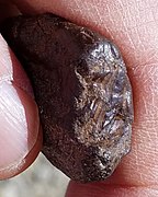 Tooth?


Greenhorn Limestone[edit]
The Greenhorn is mostly shale and many thin beds of soft chalky limestone, very little survives transport hundreds of miles downstream. Really, only Fencepost limestone and Shellrock can (very rarely) make the journey; which can be identified the presence of Inoceramus labiatus

Carlile Shale[edit]
The Carlile is also mostly shale with very, very little, soft limestone. The Blue Hills Shale member, however, features huge calcite septarian. Very rarely, a piece of their lemon or red wine colored calcite can be found.
-
 Yellow and dark "wine-red" septarian calcite.

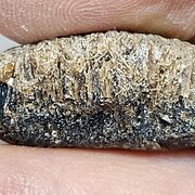
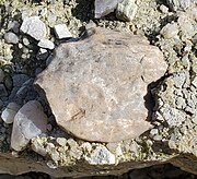
Niobrara Chalk/Fort Hays[edit]
The Fort Hays is the thickest limestone in Kansas, but it weathers rather rapidly, especially when in contact with surface frost. But, two forms are durable in the river gravel. Cremnoceramus deformis and related shell fragments are primarily identifiable by the oysters that encrust the shells, especially with slightly darker chalk inside the oyster shells. Early Ogallala Formation deposits feature cementation by green opal, commonly in contact with weathered Fort Hays limestone, greenish fragments of which can be easily found in upper Kansas River gravel.
-
 Oyster-encrusted Cremnoceramus deformis shell fragment
 -
 Oyster-encrusted Cremnoceramus deformis shell fragment
 -
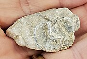 Oyster-encrusted Cremnoceramus deformis shell fragment
 -
 Opalised vertebrate ribs
 -
 Opalised vertebrate ribs
.jpg)

.jpg)


Niobrara Chalk/Smoky Hill Chalk[edit]
Smoky Hill Chalk is very soft, except for parts that were silicified from contact with the silicification events that formed the agates and cherts of the upper Ogallala Formation.
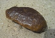
Glacial erratics[edit]
These were carried by glaciers into northeastern Kansas from Iowa and other places far to the North and a bit to the East. Except for possibly one event that has not yet be studied, the maximum extent of the deposition is the ridge between the Kansas River and the Wakarusa River to the south and the Big Blue River to the west. Pebble and cobbles have been carried into the rivers, but the boulders, some the size of a VW Microbus pretty much had lain where the glacier left them. Sioux Quartzite can be found in Manhattan and Junction City, but these are presumed to be dropstones carried up river when the glaciers formed Kaw Lake.
- Sioux Quartzite:
- Granitics:
- Pipestone:
- Taconite:
- Potentially Ordovician cherts
Front Range cobbles[edit]
Rather than carried by rivers, these are trucked in from the Front Range. I used to ignore these landscapes, after all they're just granite, or so I thought at first. But, one day when I was waiting at a gas station for a ride and go bored enough to actually look; and, I found my best leaf fossil!
- There are two primary sources, both are mostly rounded cobbles, potato-sized or larger; but, they have different rock populations.
- The rocks from the Big Thompson River at Colorado Springs are primarily all igneous and metamorphic.
- The rocks from the Arkansas River at Pueblo also have a lot of igneous, but there is much greater range of metamorphic, and there is lot of congretions, sandstone, and some Ogallala.
- Fossils tend to be root traces in the sandstones.
Silcretes[edit]
End-Cretaceous soils were widely silicified at Start-Quaternary, and so, the general sources are basement outcrops of the Ogallala Formation.
- These always stand out in gravel as highly polished tending to glistening.
- Some feature fossil root traces.
(chemically inert "kraut rock")
-
 Weathered silcrete incorporated in early Ogallala sandstone.
 -
 Found in Kansas River, silcrete cobbles can display desert varnish.
 -
 The bottom of the sample shows trace root fossils as tiny pores.


_20160410_125135.jpg)
_20160619_081653.jpg)
The western Kansas Volga German joke was "When you set a locust fencepost, put a rock on top of it. When the rock weathers away, it is time to get a new rock."
Crushed gravel[edit]
Locally, certain Flint Hills limestones are crushed for both landscaping and for paving roads and walkways. Technically, this is not DXing because the rock is all available locally. But, my first Gravel find that started this hobby was a neospiphera I stumbled upon on a park trail. Usually, anything bigger than fusilinid. My thought is that older crushed gravel was made from weathered limestone and so larger fossils are more likely to "pop out" than to be crushed.
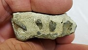
Commercial gravel[edit]
Royal Gorge pegmatite.
References[edit]
- ^ Mika Mäkeläinen. "Introduction To DXing". DXing.info. Retrieved November 12, 2016.