
User:Godsy/Portal example
Portal maintenance status: (February 2019)
|
Introduction
Polar exploration is the process of exploration of the polar regions of Earth – the Arctic region and Antarctica – particularly with the goal of reaching the North Pole and South Pole, respectively. Historically, this was accomplished by explorers making often arduous travels on foot or by sled in these regions, known as a polar expedition. More recently, exploration has been accomplished with technology, particularly with satellite imagery.
From 600 BC to 300 BC, Greek philosophers theorized that the planet was a Spherical Earth with North and South polar regions. By 150 AD, Ptolemy published Geographia, which notes a hypothetical Terra Australis Incognita. However, due to harsh weather conditions, the poles themselves would not be reached for centuries after that. When they finally were reached, the achievement was realized only a few years apart. (Full article...)
Selected general articles
-


Viking expansion in Europe: 9th century settlement10th century settlement11th century settlementRaids but no settlement
Viking expansion was the historical movement which led Norse explorers, traders and warriors, the latter known in modern scholarship as Vikings, to sail most of the North Atlantic, reaching south as far as North Africa and east as far as Russia, and through the Mediterranean as far as Constantinople and the Middle East, acting as looters, traders, colonists and mercenaries. To the west, Vikings under Leif Erikson, the heir to Erik the Red, reached North America and set up a short-lived settlement in present-day L'Anse aux Meadows, Newfoundland, Canada. Longer lasting and more established Norse settlements were formed in Greenland, Iceland, the Faroe Islands, Russia, Ukraine, Great Britain, Ireland and Normandy. (Full article...) -

Fyodor Matyushkin
Fyodor Fyodorovich Matyushkin (Russian: Матюшкин, Федор Федорович; 21 July [O.S. 10 July] 1799 - 28 September [O.S. 16 September] 1872) was a Russian navigator, Admiral (1867), and a close friend of Aleksandr Pushkin, who studied with him at the Tsarskoye Selo Lyceum.
Matyushkin graduated from Tsarskoye Selo Lyceum in 1817. After having volunteered for the navy, he participated in Vassili Golovnin's world cruise on the ship Kamchatka in 1817–1819. (Full article...) -
Otto Neumann Knoph Sverdrup (31 October 1854, in Bindal, Helgeland – 26 November 1930) was a Norwegian sailor and Arctic explorer. (Full article...) -

Stamps commemorating the 1956 Soviet Antarctic bases
The First Soviet Antarctic Expedition was led by Mikhail Somov; his scientific deputy was V. G. Kort. The expedition lasted from 30 November 1955 to 1957 and involved 127 expedition members and 75 crew members.
Three diesel-electric ships were used to transport the expedition. They were RV Ob (flagship; captain I. A. Man), RV Lena (captain A. I. Vetrov) and the refrigerator ship No. 7 (captain M. A. Tsygankov). The final ship was used only for transporting perishables. Ob and Lena were icebreakers 130m long and displacing 12,600 tons. (Full article...) -
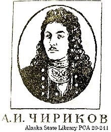
Aleksei Ilyich Chirikov (Russian: Алексе́й Ильи́ч Чи́риков; 1703 – November 14, 1748) was a Russian navigator and captain who, along with Vitus Bering, was the first Russian to reach the northwest coast of North America. He discovered and charted some of the Aleutian Islands while he was deputy to Vitus Bering during the Great Northern Expedition. (Full article...) -
Faddey Faddeyevich Bellingshausen or Fabian Gottlieb Benjamin von Bellingshausen (18 August [O.S. 9 August] 1778 – 25 January [O.S. 13 January] 1852) was a Russia German cartographer, explorer, and naval officer of the Russian Empire, who attained the rank of admiral. He participated in the first Russian circumnavigation of the globe, and subsequently became a leader of another circumnavigation expedition that discovered the continent of Antarctica. Like Otto von Kotzebue and Adam Johann von Krusenstern, Bellingshausen belonged to the cohort of prominent Baltic German navigators who helped Russia launch its naval expeditions.
Bellingshausen was born in the Estonian island of Saaremaa (Ösel), in the eponymous family. He started his service in the Russian Baltic Fleet, and after distinguishing himself joined the first Russian circumnavigation of the Earth in 1803–1806, serving on the merchant ship Nadezhda under the captaincy of Adam Johann von Krusenstern. After the journey, he published a collection of maps of the newly explored areas and islands of the Pacific Ocean. Subsequently, he commanded several ships of the Baltic and Black Sea Fleets. (Full article...) -
John Cabot (Italian: Giovanni Caboto [dʒoˈvanni kaˈbɔːto]; c. 1450 – c. 1500) was an Italian navigator and explorer. His 1497 voyage to the coast of North America under the commission of Henry VII, King of England is the earliest known European exploration of coastal North America since the Norse visits to Vinland in the eleventh century.
To mark the celebration of the 500th anniversary of Cabot's expedition, both the Canadian and British governments declared Cape Bonavista, Newfoundland as representing Cabot's first landing site. However, alternative locations have also been proposed. (Full article...) -
Richard Evelyn Byrd Jr. (October 25, 1888 – March 11, 1957), an American naval officer, was a pioneering American aviator, polar explorer, and organizer of polar logistics. Aircraft flights in which he served as a navigator and expedition leader crossed the Atlantic Ocean, a segment of the Arctic Ocean, and a segment of the Antarctic Plateau. He is also known for discovering Mount Sidley, the largest dormant volcano in Antarctica.
Byrd claimed to be the first to reach both the North and South Poles by air. However, there is some controversy as to whether or not Byrd was actually the first person to reach the North Pole. It is generally believed that the distance Byrd claimed to fly was longer than the possible fuel range of his airplane. (Full article...) -

Expedition commander Carsten Borchgrevink taking a theodolite reading in front of the Southern Cross, 1899
The Southern Cross Expedition, otherwise known as the British Antarctic Expedition, 1898–1900, was the first British venture of the Heroic Age of Antarctic Exploration, and the forerunner of the more celebrated journeys of Robert Falcon Scott and Ernest Shackleton. The brainchild of the Anglo-Norwegian explorer Carsten Borchgrevink, it was the first expedition to over-winter on the Antarctic mainland, the first to visit the Great Ice Barrier—later known as the Ross Ice Shelf—since Sir James Clark Ross's groundbreaking expedition of 1839 to 1843, and the first to effect a landing on the Barrier's surface. It also pioneered the use of dogs and sledges in Antarctic travel.
The expedition was privately financed by the British magazine publisher Sir George Newnes. Borchgrevink's party sailed in the Southern Cross, and spent the southern winter of 1899 at Cape Adare, the northwest extremity of the Ross Sea coastline. Here they carried out an extensive programme of scientific observations, although opportunities for inland exploration were restricted by the mountainous and glaciated terrain surrounding the base. In January 1900, the party left Cape Adare in Southern Cross to explore the Ross Sea, following the route taken by Ross 60 years earlier. They reached the Great Ice Barrier, where a team of three made the first sledge journey on the Barrier surface, during which a new Farthest South record latitude was established at 78° 50′S. (Full article...) -
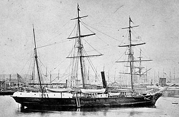
Jeannette at Le Havre in 1878, prior to her departure for San Francisco in a trip that would see her round Cape Horn
The Jeannette expedition of 1879–1881, officially called the U.S. Arctic Expedition, was an attempt led by George W. De Long to reach the North Pole by pioneering a route from the Pacific Ocean through the Bering Strait. The premise was that a temperate current, the Kuro Siwo, flowed northwards into the strait, providing a gateway to the hypothesized Open Polar Sea and thus to the pole.
This theory proved illusory; the expedition's ship, USS Jeannette and its crew of thirty-three men, was trapped by ice and drifted for nearly two years before she was crushed and sunk north of the Siberian coast. De Long then led his men on a perilous journey by sled, dragging the Jeannette's whaleboat and two cutters, eventually switching to these small boats to sail for the Lena Delta in Siberia. During this journey, and in the subsequent weeks of wandering in Siberia before rescue, twenty of the ship's complement died, including De Long. (Full article...) -

John Rae FRS FRGS (Inuktitut: ᐊᒡᓘᑲ, [aɡluːka]; 30 September 1813 – 22 July 1893) was a Scottish surgeon who explored parts of northern Canada. He was a pioneer explorer of the Northwest Passage.
Rae explored the Gulf of Boothia, northwest of the Hudson Bay, from 1846 to 1847, and the Arctic coast near Victoria Island from 1848 to 1851. In 1854, back in the Gulf of Boothia, he obtained credible information from local Inuit peoples about the fate of the Franklin Expedition, which had disappeared in the area in 1848. Rae was noted for his physical stamina, skill at hunting, boat handling, use of native methods, and ability to travel long distances with little equipment while living off the land. (Full article...) -
Sir Ernest Henry Shackleton CVO OBE FRGS FRSGS (15 February 1874 – 5 January 1922) was an Anglo-Irish Antarctic explorer who led three British expeditions to the Antarctic. He was one of the principal figures of the period known as the Heroic Age of Antarctic Exploration.
Born in Kilkea, County Kildare, Ireland, Shackleton and his Anglo-Irish family moved to Sydenham in suburban south London when he was ten. Shackleton's first experience of the polar regions was as third officer on Captain Robert Falcon Scott's Discovery Expedition of 1901–1904, from which he was sent home early on health grounds, after he and his companions Scott and Edward Adrian Wilson set a new southern record by marching to latitude 82°S. During the Nimrod Expedition of 1907–1909, he and three companions established a new record Farthest South latitude of 88°23′ S, only 97 geographical miles (112 statute miles or 180 kilometres) from the South Pole, the largest advance to the pole in exploration history. Also, members of his team climbed Mount Erebus, the most active Antarctic volcano. On returning home, Shackleton was knighted for his achievements by King Edward VII. (Full article...) -

Fram leaves Bergen on 2 July 1893, bound for the Arctic Ocean
Nansen's Fram expedition of 1893–1896 was an attempt by the Norwegian explorer Fridtjof Nansen to reach the geographical North Pole by harnessing the natural east–west current of the Arctic Ocean. In the face of much discouragement from other polar explorers, Nansen took his ship Fram to the New Siberian Islands in the eastern Arctic Ocean, froze her into the pack ice, and waited for the drift to carry her towards the pole. Impatient with the slow speed and erratic character of the drift, after 18 months Nansen and a chosen companion, Hjalmar Johansen, left the ship with a team of Samoyed dogs and sledges and made for the pole. They did not reach it, but they achieved a record Farthest North latitude of 86°13.6′N before a long retreat over ice and water to reach safety in Franz Josef Land. Meanwhile, Fram continued to drift westward, finally emerging in the North Atlantic Ocean.
The idea for the expedition had arisen after items from the American vessel Jeannette, which had sunk off the north coast of Siberia in 1881, were discovered three years later off the south-west coast of Greenland. The wreckage had obviously been carried across the polar ocean, perhaps across the pole itself. Based on this and other debris recovered from the Greenland coast, the meteorologist Henrik Mohn developed a theory of transpolar drift, which led Nansen to believe that a specially designed ship could be frozen in the pack ice and follow the same track as Jeannette wreckage, thus reaching the vicinity of the pole. (Full article...) -
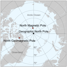
Location of the north magnetic pole and the north geomagnetic pole in 2017. The magnetic-north of the earth as a magnet is actually on the southern hemisphere: The north side of magnets are by definition attracted to the geographic north, and opposite poles attract.
The north magnetic pole, also known as the magnetic north pole, is a point on the surface of Earth's Northern Hemisphere at which the planet's magnetic field points vertically downward (in other words, if a magnetic compass needle is allowed to rotate in three dimensions, it will point straight down). There is only one location where this occurs, near (but distinct from) the geographic north pole. The geomagnetic north pole is the northern antipodal pole of an ideal dipole model of the Earth's magnetic field, which is the most closely fitting model of Earth's actual magnetic field.
The north magnetic pole moves over time according to magnetic changes and flux lobe elongation in the Earth's outer core. In 2001, it was determined by the Geological Survey of Canada to lie west of Ellesmere Island in northern Canada at . It was situated at in 2005. In 2009, while still situated within the Canadian Arctic at , it was moving toward Russia at between 55 and 60 km (34 and 37 mi) per year. In 2013, the distance between the north magnetic pole and the geographic north pole was approximately 800 kilometres (500 mi). As of 2021, the pole is projected to have moved beyond the Canadian Arctic to . (Full article...) -

Valerian Ivanovich Albanov (Russian: Валериа́н Ива́нович Альбанов; 26 May 1881 – 1919) was a Russian navigator, best known for being one of two survivors of the Brusilov expedition of 1912, which killed 22. (Full article...) -
Captain Robert Falcon Scott CVO (6 June 1868 – c. 29 March 1912) was a British Royal Navy officer and explorer who led two expeditions to the Antarctic regions: the Discovery expedition of 1901–04 and the Terra Nova expedition of 1910–13.
On the first expedition, he set a new southern record by marching to latitude 82°S and discovered the Antarctic Plateau, on which the South Pole is located. On the second venture, Scott led a party of five which reached the South Pole on 17 January 1912, less than five weeks after Amundsen's South Pole expedition. A planned meeting with supporting dog teams from the base camp failed, despite Scott's written instructions, and at a distance of 162 miles (261 km) from their base camp at Hut Point and approximately 12.5 miles (20.1 km) from the next depot, Scott and his companions died. When Scott and his party's bodies were discovered, they had in their possession the first Antarctic fossils discovered. The fossils were determined to be from the Glossopteris tree and proved that Antarctica was once forested and joined to other continents. (Full article...) -
The British Graham Land expedition (BGLE) was a geophysical and exploration expedition to Graham Land in Antarctica between 1934 and 1937. Under the leadership of John Rymill, the expedition spent two years in the Antarctic. The expedition determined that Graham Land was a peninsula. The expedition used a combination of traditional and modern practices in Antarctic exploration, using both dog teams and motor sledges as well as a single-engine de Havilland Fox Moth aircraft for exploration. Transportation to the Antarctic was in an elderly three-masted sailing ship christened the Penola, which had an unreliable auxiliary engine. Additional supplies were brought on the ship Discovery II.
The expedition was one of the last privately sponsored Antarctic missions, with only part of the cost covered by the UK government. Although the expedition had a very small budget, it was successful in its scientific objectives. Air survey photography and mapping was carried out for 1000 miles (1600 km) of the Graham Land coast. (Full article...) -

The Arctic Ocean, with borders as delineated by the International Hydrographic Organization (IHO), including Hudson Bay (some of which is south of 57°N latitude, off the map) and all other marginal seas.
The Arctic Ocean is the smallest and shallowest of the world's five major oceans. It spans an area of approximately 14,060,000 km2 (5,430,000 sq mi) and is known as one of the coldest of oceans. The International Hydrographic Organization (IHO) recognizes it as an ocean, although some oceanographers call it the Arctic Mediterranean Sea. It has also been described as an estuary of the Atlantic Ocean. It is also seen as the northernmost part of the all-encompassing World Ocean.
The Arctic Ocean includes the North Pole region in the middle of the Northern Hemisphere and extends south to about 60°N. The Arctic Ocean is surrounded by Eurasia and North America, and the borders follow topographic features: the Bering Strait on the Pacific side and the Greenland Scotland Ridge on the Atlantic side. It is mostly covered by sea ice throughout the year and almost completely in winter. The Arctic Ocean's surface temperature and salinity vary seasonally as the ice cover melts and freezes; its salinity is the lowest on average of the five major oceans, due to low evaporation, heavy fresh water inflow from rivers and streams, and limited connection and outflow to surrounding oceanic waters with higher salinities. The summer shrinking of the ice has been quoted at 50%. The US National Snow and Ice Data Center (NSIDC) uses satellite data to provide a daily record of Arctic sea ice cover and the rate of melting compared to an average period and specific past years, showing a continuous decline in sea ice extent. In September 2012, the Arctic ice extent reached a new record minimum. Compared to the average extent (1979–2000), the sea ice had diminished by 49%. (Full article...) -
Joris Carolus (c. 1566–c. 1636) was a Dutch cartographer and explorer who was employed by the Noordsche Compagnie and the Dutch East India Company. (Full article...)
-
Captain Charles Clerke (22 August 1741 – 22 August 1779) was an officer in the Royal Navy who sailed on four voyages of exploration (including three circumnavigations), three with Captain James Cook. When Cook was killed during his 3rd expedition to the Pacific, Clerke took command but died later in the voyage from tuberculosis. (Full article...) -
Joseph-René Bellot (18 March 1826 – 18 August 1853) was a French naval officer and Arctic explorer. (Full article...) -
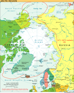
The 10 °C (50 °F) mean isotherm in July line (in red) commonly defines the border of the Arctic region.
Arctic exploration is the physical exploration of the Arctic region of the Earth. It refers to the historical period during which mankind has explored the region north of the Arctic Circle. Historical records suggest that humankind have explored the northern extremes since 325 BC, when the ancient Greek sailor Pytheas reached a frozen sea while attempting to find a source of the metal tin. Dangerous oceans and poor weather conditions often fetter explorers attempting to reach polar regions, and journeying through these perils by sight, boat, and foot has proven difficult. (Full article...) -
Vice Admiral Sir Henry Kellett, KCB (2 November 1806 – 1 March 1875) was an Irish naval officer and explorer. (Full article...) -

Vasily Yakovlevich Chichagov (Russian: Василий Яковлевич Чичагов, romanized: Vasiliy Yakovlevič Čičagov; 11 March [O.S. 28 February] 1726 – 16 April [O.S. 4 April] 1809) was an admiral in the Russian Navy who distinguished himself in the Russian–Swedish war, and an explorer.
He was the father of Pavel Chichagov, a Russian admiral during the Napoleonic Wars. (Full article...) -
Vostok Station (Russian: ста́нция Восто́к, romanized: stántsiya Vostók, pronounced [ˈstant͡sɨjə vɐˈstok], meaning "Station East") is a Russian research station in inland Princess Elizabeth Land, Antarctica. Founded by the Soviet Union in 1957, the station lies at the southern Pole of Cold, with the lowest reliably measured natural temperature on Earth of −89.2 °C (−128.6 °F; 184.0 K). Research includes ice core drilling and magnetometry. Vostok (Russian for 'east') was named after Vostok, the lead ship of the First Russian Antarctic Expedition captained by Fabian von Bellingshausen. The Bellingshausen Station was named after this captain (the second ship, Mirny, captained by Mikhail Lazarev, became the namesake for Mirny Station). (Full article...)


.jpg)


Need help?
Do you have a question about Polar exploration that you can't find the answer to?
Consider asking it at the Wikipedia reference desk.
Selected images
-

-
 Roald Amundsen, Helmer Hanssen, Sverre Hassel, and Oscar Wisting at the South Pole (from Polar exploration)


Subcategories

- Select [►] to view subcategories
Subtopics
Associated Wikimedia
The following Wikimedia Foundation sister projects provide more on this subject:
-
 Commons
Free media repository -
 Wikibooks
Free textbooks and manuals -
 Wikidata
Free knowledge base -
 Wikinews
Free-content news -
 Wikiquote
Collection of quotations -
 Wikisource
Free-content library -
 Wikiversity
Free learning tools -
 Wiktionary
Dictionary and thesaurus