User:Elvatomasvato/sandbox
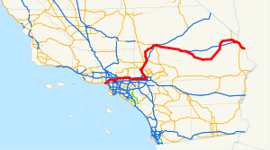
| Los Angeles Metropolitan Area Eastern Bypass Route | ||||
| Route information | ||||
| Maintained by Caltrans | ||||
| Length | 432 mi (695 km) | |||
| Major junctions | ||||
| West end |
| |||
| ||||
| East end | ||||
| Location | ||||
| Country | United States | |||
| State | California | |||
| Highway system | ||||
| ||||
| Federal Highway 100 | ||||
|---|---|---|---|---|
| Carretera federal 100 | ||||
| Tijuana and San Diego Metropolitan Area Southern Bypass | ||||
| Route information | ||||
| Maintained by Secretariat of Communications and Transportation | ||||
| Length | 143 mi (230 km) | |||
| Major junctions | ||||
| North end | ||||
| ||||
| South end | ||||
| Location | ||||
| Country | Mexico | |||
| State | Baja California | |||
| Highway system | ||||
| ||||
| East Los Angeles Interchange | |
|---|---|
| Malfunction Junction "The Beast" L.A. Interchange "East Delay" Interchange Nickle/Dime Interchange | |
| Location | |
| Los Angeles | |
| Roads at junction | |
| Construction | |
| Type | Spaghetti junction |
| Maintained by | Caltrans |
| Will Rogers Highway | ||||
 Route 66 highlighted in red | ||||
| Route information | ||||
| Maintained by Caltrans | ||||
| Length | 315 mi (507 km) | |||
| Existed | 1926–1964 | |||
| Major junctions | ||||
| West end | ||||
| East end | ||||
| Location | ||||
| Country | United States | |||
| State | California | |||
| Highway system | ||||
| ||||


