User:Drumguy8800/Mountain Creek
Mountain Creek | |
|---|---|
 A building in the Preston Center neighborhood | |
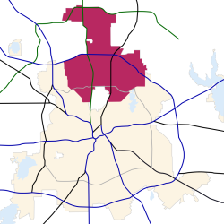
 Location in Dallas | |
| Country | United States |
| State | Texas |
| Counties | Collin, Dallas, Denton |
| City | Dallas |
| Elevation | 568 ft (173 m) |
| ZIP codes | 75206, 75209, 75220, 75225, 75229, 75230, 75231, 75240, 75243, 75244, 75248, 75251, 75252, 75287 |
| Area code(s) | 214, 469, 972 |
North Dallas is an expansive area of numerous communities and neighborhoods in Dallas, Texas, (USA). It spans portions of three counties: Collin, Dallas, and Denton, and has strong social ties to two enclaves of Dallas (University Park and Highland Park) and a near-enclave (Addison) of Dallas. It is widely considered the wealthiest part of Dallas.
History[edit]
Geography[edit]
Mountain Creek is home to Mountain Creek Lake, a man-made reservoir located south of SH 180, west of SH Spur 408, north of I-20, and east of FM 1382. The lake has a catchment area of 295 square miles (764 km2) and its surface covers an area of 2,710 acres (10.97 km2).
Cityscape[edit]
Neighborhoods[edit]
Culture[edit]
Shopping[edit]
Economy[edit]
Demographics[edit]
Education[edit]
The Collin County portion of North Dallas is served by the Plano Independent School District.
The Dallas County portion of North Dallas is served by the Dallas Independent School District, and students are zoned to either Emmett Conrad, Hillcrest, Thomas Jefferson, or W. T. White High Schools.[2]
The Denton County portion of North Dallas is served by the Carrollton-Farmers Branch Independent School District.
Libraries[edit]
- Fretz Park Branch Library[3]
- Park Forest Branch Library[4]
- Preston Royal Branch Library[5]
- Renner Frankford Branch Library[6]
- Timberglen Branch Library[7]
- Walnut Hill Branch Library[8]
Infrastructure[edit]
Health systems[edit]
Transportation[edit]

As the majority of north Dallas was developed in the late 20th Century, the primary mode of local transportation is the automobile and the area has a low density compared with neighborhoods built in the early 20th Century. Efforts made by the City of Dallas and Dallas Area Rapid Transit to increase the availability of alternative modes of transportation have received varying degrees of support from north Dallas residents. Since 1996, two light rail lines flanking north Dallas on the east have been constructed and well-received, and two more are under construction that will flank north Dallas on the west, in northwest Dallas. However, plans to build a commuter or light rail line through the north Dallas area along the "Cotton Belt" (the St. Louis Southwestern Railway) has met opposition from residents and local organizations.[9]

North Dallas's road network was developed according to the street hierarchy school of urban design. Roads in the area are separated into major limited-access highways, high-capacity principal arterial roads, mid-capacity minor arterial roads, mid-capacity collector roads and minor streets. The most organized of these systems is north Dallas's modified grid plan of principal arterial roads, which runs on a standard N/S/E/W grid. The routing of limited-access highways through north Dallas is based on the area's proximity to Dallas's downtown freeway loop, as Dallas's freeway system was built according to the hub-and-spoke paradigm. North Dallas's major north-south highways radiate out of the downtown freeway loop and cut through north Dallas at various angles — Interstate 35E runs northwest/southeast, the Dallas North Tollway runs north/south, and U.S. Route 75 (North Central Expressway) runs northeast/southwest. Additionally, four separate beltways arc across north Dallas: in order from their proximity to downtown, they are Northwest Highway (SH Loop 12) (a principal arterial road), Interstate 635 (a limited-access highway), Belt Line Road (a principal arterial road), and the President George Bush Turnpike (a tolled limited-access highway).
Dallas Area Rapid Transit (DART) provides the north Dallas area with bus service, light rail lines, and HOV lanes. DART began operating its light rail lines in north Dallas in 1996: The Red Line connects north Dallas to Oak Cliff, south Dallas, downtown, Uptown, Richardson and Plano. The Blue Line connects north Dallas to south Dallas, downtown, Uptown, east Dallas, Lake Highlands, and Garland. DART has also begun construction on its Green and lines, which will run just to the west of north Dallas in northwest Dallas. The two lines will serve DFW Airport, Irving and Las Colinas, Carrollton, Farmers Branch, the Stemmons Corridor, Victory Park, downtown, Deep Ellum, Fair Park, south Dallas and Pleasant Grove.
Dallas's Love Field Airport is located in north Dallas, near the Bluff View and Devonshire neighborhoods. The Dallas-Fort Worth Metroplex's major international airport, Dallas-Fort Worth International Airport, is located a short distance to the northwest. Additionally, Addison Airport, a general aviation airport, is located adjacent to north Dallas in Addison.
See also[edit]
References[edit]
- ^ Fox Hollow Homeowners Association. Retrieved on 13 June 2007.
- ^ Dallas ISD - 2007 School Feeder Patterns. (Maps: Hillcrest, Jefferson, White.) Retrieved on 29 April 2007.
- ^ DallasLibrary.org - Fretz Park Branch Library. Retrieved on 29 April 2007.
- ^ DallasLibrary.org - Park Forest Branch Library. Retrieved on 29 April 2007.
- ^ DallasLibrary.org - Preston Royal Branch Library. Retrieved on 29 April 2007.
- ^ DallasLibrary.org - Renner Frankford Branch Library. Retrieved on 29 April 2007.
- ^ DallasLibrary.org - Timberglen Branch Library. Retrieved on 29 April 2007.
- ^ DallasLibrary.org - Walnut Hill Branch Library. Retrieved on 29 April 2007.
- ^ Stephanie, Sandoval (2007-04-07). "DART rail feud spills into Austin". The Dallas Morning News. Belo Corporation. Retrieved 2007-04-30.

