
User:DerekvG/sandbox/edits fortifications Antwerp

.JPG)

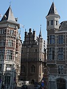
Antwerp was developed as a fortified city, but very little remains visible of the fortifications build between the 10th and 17 th century. Only some fragments remain of the first enceinte, a 19th century replica of a Burg (castle) named House het Steen which has been partly rebuilt near the Scheldt-quais during the 19th century works of the Scheldt quayside. Fragmentsof the first city wall the and can be seen near the Vleeshuis-museum, at the instersection of the Bloedberg and Vleeshuisstraat, and at the corner of House het Steen. Large parts of the canals that protected the city between the 12th and 16th century have been covered and used as a sewage system. Both the 16th century city walls and the 19th century fortifications have been covered up by major infrastructure works during the late 19th and 20th century.
This article[1] is related to the development of the Port of Antwerp; other related articles are History of Antwerp and Historic timeline of Antwerp.
Overview[edit]
Antwerp's development as a fortified city is documented between the 10th and the 20th century. The fortifications were developed in Nine phases (which are numbered according to the Historic Map 1886 made by Alois Scheepers) :
- First fortification 980 AD (Map Scheepers : I) : first fortified wall and ditch, improved around 1100
- Second fortification expansion before 1200 (Map Scheepers : II) : first vlieten and ruien (city canals) were dug
- Third fortification expansion during 13th and 14th century (Map Scheepers : III) : expansion to the south with vesten
- Fourth fortification (Map Scheepers : IV) : expansion to the north with more ruien
- Fifth fortification during the 14th century (Map Scheepers : V) : on the south and east side of the city
- Sixth fortification 15th century (Map Scheepers : VI) : under the reign of the Dukes of Burgundy
- Seventh fortification 16th century (Map Scheepers : VII) : the construction of the Spanish fortifications
- Eigth fortification 16th century (Map Scheepers : VIII) : and later the citadel, by the Duke of Alba, under the reign of Philips II of Habsburg,
- Nineth fortification early 19th century (Map Scheepers : IX and X) : construction of a Brialmont fortification around the city and 1st ring of Brialmont fortresses about 5-10 km from the original burg and 19th century after the independence of Belgium: construction of a 2nd ring of Brialmont fortresses about 20 km from the original burg
From the 18th century major works and construction projects have changed the nature of the original innercity canals. In the 19th and 20th century the projects for the development of the port have destroyed all visible signs of the fortification works and made the canals disappear from view, major raod works destroyed the Spanish fortifications and the mordernisation of the water front destroyed most of the 10tyh century Burg. Some of the latest fortifications are still being used as military installations.
De Vrijheid van Antwerpen[edit]
The fortifications of Antwerp are not merely a question of infrastructure and architecture like walls, ditches, gates and bridges, the fortification shouldn't be seen outside the context of the surrounding countryside and the entitlement to or influence exercised over that territory. This fief(territory) is called the Vrijheid van Antwerpen (see Brugse Vrije and castellany for further reference). In the medieval Feudal society a fief was awarded by the liege Lord to its vassals, also cities like Antwerp acquired fiefs, sometimes awarded but more often through acquisitions by the abbyes on the cities territory or legacies from important poorters. The Vrijheid van Antwerpen was under the authority of the Schepenbank (Council of Schepenen (Aldermen)) of the city of Antwerp, who both legislated and acted as judges. Medieval documents show that within the territory of Antwerp more then one Schepenbank had authority.
Before the 11th century[edit]
The Roman period[edit]
For most current urban (inhabited) locations in the southern Netherlands (the former roman provinces of Belgica and Lower Germania), dating back before the medieval period, archeological finds have determined that the eldest and most important urban centers are based on Roman settlements with trade and industrial character.[2] [3]. For Antwerp this should be interpreted in broad sense. Archeological excavations during the 1960's and 1970's : Prof. Van De Walle excavated near het Steen (1960-72, on the Scheldt quays site) [4][5][6][7] and by prof. Oost near the Vleeshuis and Antwerp City Hall (1974-76, cityparking site)[8] have determined that on the site of the 10th century burg, roman artefacts were found in a thin (20-30 cm layer) which was probably an egalisation layer of earth excavated elsewhere, however the city parking site (outside the burg) showed signs of a Gallo-roman settlement and in different areas on the territory of the current city remains of smaller Roman an Gallo roman settlements were found. The main concentration is at the area where in the 12th century St Michielsadbij was build. (see below)
The excavation material indicates none of the material is younger then the 3rd century, and that the Carolingian artefacts recovered are found in a layer sitting right on top of the Roman layer (without a layer of Merovingian artefacts). [4][8]
The Merovingian period[edit]
In the 7th century, two evangelising bisshops are known to have visited the region.
Saint Eligius (or St Elooi whose holy day is still celebrated in Antwerp), bisshop of Noyon-Tournai since 641, visited the area on the eastern embankment of the Scheldt. [9][10]
Saint Amandus, bishop of Tongeren-Maastricht, has visited in the 4th decennium of the 7th century the region of Antwerp. [11][12][13]
In a private donation charter (kept in the abbey of Echternach)[14] dated 726, a certain Rauchingus (a Merovingian Prefect), donated a church build by Saint Amandus to Saint Willibrord first Bishop of Utrecht. The charter mentions that is was located infra castrum Antwerpis (inside the Antwerp Castrum) and that it was dedicated to St Peter and St Paul (like many of the churches and build by Saint Amandus). The charter also mentions that the church belonged to an unnamed abbey or convent which ceased to exist (destroyed) during the 9th and 10 th century (probably due to raids by the Normen). The grounds of that disappeared church and abbey came later into the possession of the German emperor, who gave them in turn to the Margrave of Antwerp. Based on the different finds the location of the 8th century castrum would be most likely the area of the St Michielsadbij(St. Michael's Abbey). [15]
9th Century AD[edit]
Archaeological excavations and research conducted research in 2008-2009 showed that in the ninth century, the fortress of Antwerp was fortified by a palisade, and later by an earthen wall, made of cut sods of turf, sand and wood and that it was 13.5 metres (44 ft) wide and at least 4 metres (13 ft) high. The earthen wall was located at the trace of of the later stone fortress wall. [16]
-
1
-
2
-
 3
3

First fortification ca. 10th century AD[edit]

.jpg)

Since the Treaty of Verdun (843) the river Scheldt was the natural and political border between the County of Flanders (belonging to the Kingdom of France) to the west and the German Empire.
In 980 the German Emperor Otto II awarded Antwerp a margraviate, and ordered a fortification built on the wharf, part of his fortification program for his western border. Around 1106 the Counts of Leuven, the later Dukes of Brabant, acquired the Margraviate of Antwerp, and it continued to be part of the Duchy of Brabant until the end of the Ancien Régime.[17][18]
The area of the first fortified burg on the wharf was no later then 900 CE - but also for the first time since the Roman era (3rd century) - inhabited [4][8] [15]. The vicus named "Antwerpen" is cited in a source dated 900.[19] The first stone fortification consisted of a wall and ditch surrounding an enceinte built partly on the wharf.
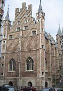
- The wall was about 5 metres (16 ft) high and 1.35 metres (4.4 ft) thick and built in Tournaisian limestone. In 1104 Emperor Hendrik IV reinforced the walls to 12 metres (39 ft) high and 2 metres (6.6 ft) thick. The remnants of this wall can still be seen near the west face of the Vleeshuis at the end of the Vleeshuisstraat" .
- The ditch was located at the north, east and southside of the wharf, and was about 5 metres (16 ft)-10 metres (33 ft) wide. The north and east part of the ditch was located at the current location of the street called Burchtgracht (a name that translates literally into "fortress ditch"), in the south is was at the Palingbrug going west to the Scheldt river. In the middle was the Bloedberg[20]
- The wharf was a dry landmass, a dry hill protruding about 30 m into the main track of the river Scheldt (measured from the current 19th-century Scheldt-quaiside). The rivershore sloped steeply into the river at the south and west of the wharf and more gently at the northside (the quays in the drawings to the right were constructed at a later date). On the westside there was only a fortification wall (no ditch) facing the river with a tollhouse at the wharfgate, and a large wharf area between the river and the fortification wall.
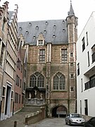
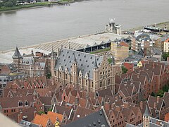
The enceinte within the wall was about 2.5 hectares (6.2 acres) in size, and contained 3 streets: the old Steenstraat (the current ramp leading to the het Steen building), the Zakstraat to the east (which partly remains) and the Mattestraat to the north, and there was a square in the middle : the Burgplein. Thanks to the excavations of Van de Walle, we know that the houses face the street with their narrow gable fronts and the saddle roofs were perpendicular to the street axis, the streets were covered with wooden planks [4] Within the enceinte the most important buildings were:
- house het Steen, (part of the current monument), which among other function served as a prison;
- house het hof van Cruyninghe : the Margrave's residence);
- the St Walburga church (which has entirely disappeared), which was dependant of the St Michielskerk (see below)
- the Reuzenhuis (House of the Giant modo House of the Teutonic Knights) which was reconstructed in 1898 in Buitenland,Bornem [21][22];
- the Vierschaer the tribunal;
- a refuge of the Affligem Abbey;
- and obviously a brewery.
During recent excavations behind the Vleeshuis on the intersection of the current Vleeshuisstraat and Burchtgracht, the remainder of the medieval wall structure was excavated and also the floor of the cellar of house De Gans (The Goose, an inn) and a well. Another part of the fortification wall that had been enclosed in the old Badhuis building (formerly the public baths) was made visible again when that building was demolished (a new structure has been built on the Bathhouse site, but the remainder of the medieval fortification wall is now better preserved, see gallery). [23] [24] [25]
.PNG)
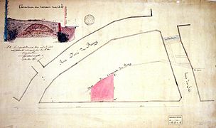
Just outside the south wall and the ditch was the Vismarkt (fish-market, west of the Steenstraat gate) the etch (see picture on right) represents correctly the location of the fishmarket relative to het Steen but the depicted gate is not Steenstraatgate.
The butchers' guild built a slaughterhouse that would have been located at the current location of the Oude Beurs ( as can be seen on the overlay picture at the top of this section) the Oud-Vleeshuis, the first butchery which has entirely disappeared. Later the butchers rebuild the Vleeshuis on top of the Palinggracht and Burcht gracht (the building currently still can be visited as a museum), at the southeast, south of the Zakstraat-gate.
-
 1
1 -
 2
2 -
 3
3 -
 4
4 -
 5
5 -
 6
6 -
 7
7 -
 8
8 -
 9
9


.JPG)


.jpg)

Second Fortification 12th-14th century : the Ruien[edit]


Before the 13th century[edit]
The ruiendriehoek (canaltriangle map1[27], and canaltraingle map2[28]) [29] The space between the stone fortification wall and the ditch quickly filled with wooden sheds and wattle and daub houses, as the city quickly outgrew its initial fortification, and by 1200 it had quadrupled in surface.[30] [31] Because trade had become the main activity of the city, canals were dug around its extremities, to allow barges to bring cargo into the city to and from the ships moored at the wharf. Those canals were called ruien (plural of rui).[32] The canals flooded at high tide and emptied at low tide. The canals that connected with the main river Scheldt were called vliet (plural vlieten).[33] Over the canals bridges would connect the city to the countryside. [34] [35][36][37] Initially the barges moored in the early canals would come to rest on the muddy bottom making cargo handling nearly impossible. So at certain places attempts were made to build wooden jetties and stone fortified quays to replace the sloping embankments of the canals such that barges could be moored alongside and be discharged and loaded even if the canal was empty of river water.
The canals were considered the second fortification of Antwerp. The triangle of canals (ruiendriehoek) enclosed about 22 hectares (54 acres) or 8 times the original fortified burg[31]. All of the ruien and vlieten of the ruiendriehoek heve been covered and served as the city sewage system, the system is open for visits by tourists.[38] The current street names still remind of the "rui", "vliet" below it. Four bridges allowed access to the city, and the current streetnames terminating by -"brug" (bridge) remind of those bridges.[39]
The ruiendriehoek consisted of following streets :
- Koolkaai is the remainder of the Holenvliet" or "Kolenvliet", where charcoal would come to the city,
- the Holenrui that linked Kolenvliet to Koepoortbrug has disappeared (which was covered in the 13th century)
- Koepoortbrug is the first visual remainder of the first ruiensystem, through the Koepoortbridge and citygate cattle would be brought to the nearby Veemarkt(cattlemarket) where it was bought by the butchers; the cattle went directly to the Vleeshuis (which was a nearly industrial slaughterhouse in that era);
- Minderbroedersrui is over the actual location of the Voldersrui [29] (in the 13th century), the streetname refers to the order of the Minderbroeders (Order of Friars Minor) who build a monastery just outside the canal in 1451 (currently the building of the Royal_Academy_of_Fine_Arts_(Antwerp), at the Mutsaertstraat;
- Wijngaardbrug was the most eastern corner of the city (at the end of the current Wolstraat), was the most eastern point at a distance of about 600 metres (660 yd) from the Scheldt river [31];
- Jezuïtenrui is partly on the map but is aligned with the north embankment of the old canal, the canal runs in a fairly straight line form the Wijngaardbrug under the Saint Carolus Borromeus church towards the Melkmarkt, the name of the jezuitenrui refers to the Society_of_Jesus which was established much later during the 16 th century, the original name might have been Korte rui (Shortcanal) has disappeared from records, ;
- Reinoldsbrug has disappeared but would have been approximately at the intersection of the Melkmarkt and Korte Nieuwstraat
- Kaasrui ran in a fairly straight line to the Broodbrug and Suikerrui what is currently the Lijnwaadmarkt next to the Cathedral , the street name was moved north to it's current location,
- Broodbrug has also disappeared but would be located at currently the intersection of Suikerrui and 'Hoogstraat
- Suikerrui is not on top but slightly south of the embankment of its covered namesake
- Botervliet was the most southern canal but it has disappeared completely with under the quays after the 19th century works on the waterfront.<[40]
It should be noted that the Forum (currently Grote Markt, the main square in front of Antwerp City Hall) was incorporated in the first canal triangle.[41]
Sint-Michielsabdij 11th and 12 th century[edit]

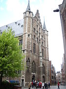
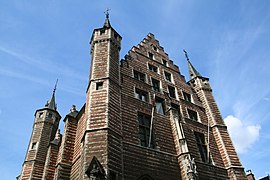
At about 1 km to the south of the 10th century fortified Burg on the Wharf, Saint Norbert founded in 1124 the Sint-Michielsabdij, an abbey of his Norbertine-order (Premonstratensians, aka Order of Canons Regular of Prémontré, and, in Britain and Ireland, as the White Canons, from the colour of their habit), this abbey serve in many periods as part of the fortification.
Several historians like (Jean-Baptiste Gramaye, Lodewijck van Caukercken, Mertens en Torfs) indicate that a Roman temple dedicated to Mars could have existed where the new abbye was erected. [42]. As explained earlier, arond the 7th century, a church (dedicated to St Peter and St Paul, and build by St Amandus) and abbye may have replaced the roman temple, which had disappeared by the 9th century. At the latest by the second quarter of the 10th century a church dedicated to St Michael had been build [30] of which the later St Walburga-chapel in the Burg was a dependency.
During the 13th century[edit]

(first expansion map [43] and first expansion before 1250 map [44] [45]
Soon the pressure of the growth of the city would soon provoke construction of buildings on the outside of the ruien-triangle, the bridges that crossed the canals were increasingly fortified, the Minnebrug, was build in the middle of the Minderbroedersrui. [41] On the southern canals (Botervliet, Suikerrui and Kaasrui) more bridges we build during the expansion in the 13th century [41] :
- the Ooftbrug crossed the Botervliet near the Scheldt,
- the Pottersbrug crossed the Suikerrui
- the Volaerdsbrug
- the Torfbrug
As trade increased the pressure for build two expansions to the fortification canals increased, more over the new parochial church of Our Lady, and its immunitydomain were outside the fortification, and two expansions occurred during the 13th century.
To the south[edit]
Before 1250 a southern extension of the ruien was dug in the depression after the terp (mount) of the Hoogstraat. The new canals were named vest.[46] [35][36][37]
- the St Cathelijnevest, connected at the Wijngaardbrug to the Jezuitenrui and the Minderbroedersrui, in the middle the Cathelijnebrug was build;
- At the southern end of the St Cathelijnevest was the Meirbrug;
- where it connected to another vest of which the name was lost (but suspected Raemvest) at the current trace of the Wiegstraat;
- Lombardenvest made a right turn, in western direction of the Scheldt, towards
- the Cammerpoort and connected to the
- Steenhouwersvest
- St Jansbrug and St Janspoort
- St Jansvliet. [41]
The extension works created an an earthen wall on the cityside of the canals from the Koepoortbrug until the St Jansbrug, dit verdedigings kunstwerk werd omschreven als murus Antwerpensis of castellum Antwerpense. The bridges became fortified and had stone gatebuildings. [41] The different gates served different purposes and handled different traffic, only three gates would actually connect to major roads and the hinterland of the Duchy of Brabant, on the south side :
- St Janspoort was the link between the St Michaelsabbye and the Forum , through trading district of the Hoogstraat
- Cammerpoort was the link to the heart of the Duchy of Brabant, Mechelen, Brussels and Leuven
On the east side :
- Meirpoort allowed farmers to go to the markets to offer their produce
- Cathelijnepoort
- Wijngaardpoort or Kipdorppoort , connected the city to the road to Turnhout
And to the North
- Koepoort still functioned to get cattle to the cattlemarket (Veemarkt) but also connected to the road to the north of the Duchy of Brabant Bergen op Zoom and Breda
All these gates disappeared in the early 16th century, only the St Janspoort survived until 1581. [47]
This southern extension effectively doubled the surface of the city again to about 42 hectares (100 acres). As of 1220 the Forum, which had become the heart of the city, was renamed to Markt. [48]
The 10th century Burg[edit]
The fortified 10th century Burg became the residence of the Margrave and cities notability, and their households.
The markets[edit]
At the west side the wharf served the city as its harbour, major area of trade with other cities.
Associated with cities is the market function that allows the city dwellers to interact with the farmers in the neighbouring countryside. [49]
- adjacent to the wharf, to the south and between the Burg and the Botervliet was the fishmarket (the oldest market since the 10th century)
- also on the south of the wharf was the Waag where merchandise could be weighed (for trade and for taxing purposes)
- a dairy market, the Botermarkt, was located where the current Suikerrui and Kaasstraat meet
- the grain market was on the Oude Koornmarkt
- the poultry and small livestockmarket was on the current Eiermarkt
- the large cattlemarket was on the Veemarkt (which is close to the Vleeshuis (Butcher's hall)
To the north[edit]
(Second expansion map [50]
and mapCite error: A <ref> tag is missing the closing </ref> (see the help page). )
Around 1250 the southern expansion was finished and the attention turned to the north where an area of 6 hectares (15 acres), important as meadows, named Den Dries was incorporated in the fortified city [47], and the Dominican order decided to build a monastery, the "Predikherenklooster". The Holenrui was filled up again, which meant there was no waterpassage between the end of the Kool- or Kolenvliet (current streetname Koolkaai) and the Koepoortbridge and the Minderbroedersui. In order to create a passage to the Minderbroedersrui 3 new canals were dug around the monastery:
- the Verversrui over the northside of the convent;
- Falconrui curbed east under the current Huikstraat, Falconrui and Stijfselrui;
- and a canal of which the name has disappeared and cannot be traced in the documents, but was situated under the Oudemanstraat;
- the St Pietersvliet was dug to the north of the Koolvliet, a new access canal between the Scheldt and the Verversrui. [47]
Sint-Michielsabdij 13th century[edit]
By the end of the 13th century the Sint-Michielsabdij extended over 600 metres (660 yd) along the Scheldt shores just 200 metres (220 yd) south of the St Janspoort (and 200 metres (220 yd) wide at its widest) an area of about 10 hectares (25 acres) outside the city fortification. Although enclosed by a wall, the convent was not fortified in a military fashion.
The abbye obtained large sections of land in and arround Antwerpen, like the heerlijkheid of Kiel and Beerschot, the land of Haringrode and Zurenborg and as late as 1674 Berendrecht and Zandvliet, which helped shape the ultimate territory of Antwerp.
Expansion outside the fortified city[edit]

Over the course of the 13th century the economic growth of the Duchy of Brabant and particularly of Antwerp, occurred at the detriment of Bruges. The Zwin river (that connected Bruges to the sea) filled with sandy deposits, while the most southern branch of the Scheldt Delta (between Zeeuws-vlaanderen and the islands of Walcheren and Zuid-Beveland, currently Westerschelde) broadened and deepened by an increase in flow of the Scheldt river, allowing more traffic. (see picture of historic map)
In the area east of the Sint-Michielsabdij and South of the Steenhouwersvest important guests and dignitaries enjoyed the cities hospitalities of the Prinsenhof. At the other side of the Boeksteeg the Gasthuis St Elisabeth(hospital) and the St Joriskapel (Chapel of St George arose). East of the Cathelijnepoort and Wijngaardpoort the Kipdorp district developped, while slightly to the north at the Koepoort the Klapdorp district and the new Paardenmarkt (horse market) took shape south of the Falconrui.
Third Fortification : Between 1295 and 1325 John II, Duke of Brabant[edit]
(third extension map [51] and map[52] ) [45]
At the end of the 13th century (1295) John II, Duke of Brabant inherited the Duchy of Brabant, through his marriage with Margaret Plantagenet (daughter of King Edward I of England) in 1290 [53][54][55][56], he aligned himself with England rather the with his french kinsmen the Dampierres,Count_of_Flanders. When Floris V, Count of Holland allied himself with the French, Antwerp and the Scheldt river became vulnerable in a military strategic sense.[29] Duke John II decided to create new fortifications, which made the city grow to 156 hectares (0.60 sq mi).
The expansion of the city outside the 13th century vesten made those canals useless as fortifications. Duke John II started his fortification works on the southside of the city , south of the St Michaelsabbye to face the threat from the Count of Flanders, via the Scheldt river, from Rupelmonde (on the leftbank of the Scheldt river, across and facing the debouchemant of the Rupelriver, thet belonged to the County of Flanders) with the building (around 1300) of a tower with the popular name Verloren Cost or Cost Verloren (later the Kronenburg-tower) on the river bank [57].
The total surface of the fortified city before the fourth expansion of the fortifications was 156 hectares (0.60 sq mi) three times that of the 13th centry second fortification.[29]
To the south[edit]
The new southern fortification which was gradually build in stone, incorporated the St Michielsadbij [39] inside the fortified city, then was build in a nearly straight line east to Begijnhof (where currently the Begijnenstraat is). At the corner of the currrent Kloosterstraat and Kronenburgstraat the Kronenbrugpoort (Kronenburggate, Secured the route south along the Scheldt and took over the role of the St Janspoort. The new southern fortification took a north eastern turn at the Begijnhol gate towards the St Jorischurch(St Georgeschurch) , where in 1313 the construction began of the St Jorispoort (St Georgesgate) that secured the main road towards Mechelen and Brussels, and the Blauwe toren(Bluetower, currently Blauwtorenplein, build around 1310).[40]
As important as the inclusion of the St Michaelsabbye was the inclusion of the St Georgeschurch (the chapel that existed since 1116 became a full parochail church in 1304) had served the area's known as "Harincrode" , de Lei and the Heerlijkheid Kiel and the incorporation of the St Elisbethsgasthuis.[58]
To the east[edit]
From the Blauwtorenplein the fortification took a northern route along the canal to Herentals(currently Oude Vaartplaats), the Wapper (where Rubens would build his residence and atelier 2 centuries later) and the Klarenstraat towards the Cauwenberg right up to the Paardenmarkt where it joined the north old fortification of the Falconrui. This eastern fortification was build hastily, by digging ditches, using the earth to make an earthen dyke because it became clear the expansion of the city would make this only a temporary defense. Already before 1325 gates were being build that would become part of the 4th expansion of the fortification at Kipdorppoort abt. 200 metres (220 yd) further to the east of the 3rd expansion ditch, and at the Rodepoort (Red gate, at the intersection of Cauwenberg and Paardenmarkt).[47]
On the Waterfront (west)[edit]
A lot more attention and effort was given to the fortification along the Scheldt river, as can be seen on the 16th century print (from the Rijksmuseum Amsterdam Collection) (see below, please note that unlike this 16 th century picture the third fortification would not be a gated stone wall on the landside). Earlier during the 11th century a fortification wall and gate had been build leaving the west side of the wharf as a maritime cargo handling zone, where very early on the first wooden crane had been build. On the artwork below it should be noted that the western fortification were don in stone, and in some areas the city walls are standing with their feet in the river, build between the river embankment and the water, with gates allowing access to the vlieten and the inner city canal network. In other area's jetties allowed ships to moor near the the gated fortification walls, leaving a wharf space between the river and the fortification for merchandise handling. These waterfront fortifications were considered very important, proven by the fact that they were kept intact until the 19th century, and they were demolished by the Scheldt embankment works in 1880.
Combining the 16th century print with the third extension map[52], the waterfront fortification can be described in detail, from the north to the south:
- the original Werf and Werfpoort[40], in front of the St Walburgachurch, with in the north the wooden crane; (the two jettis north of the wharf, on the 16th century print image below, are of a later date)
- in the south of the original wharf were still located the Vismarkt and the Viskoperstoren(Fishmongerstower, demolished in 1797)
- the Viskoperstoren separated the orignal wharf from a second jetty the so called "de Gate" Cite error: A
<ref>tag is missing the closing</ref>(see the help page). A lot of windwills can be seen on the etched panorama image, mills served 2 purposes : milling grain for consumption and pumping water to keep the city dry and evacuate sewage (water for consumption was pumped up from the groundwater layers under the city) to the canals and fortification ditches.
The Meir[edit]
-
 Cathedral of Our Lady - Antwerp, Belgium - panorama
 -
 Antwerp Central station front
 -
 Antwerp Central station appraoched form the Meir
 -
 Antwerp Meir facing west looking at Boerentoren (hiding the cathedral)
 -
 Antwerp Meir facing west looking at Innovation department store ( hiding the Station)
 -
 Antwerp at the end of the Meir looking down Leysstraat, The Keyserlei at the Central station
 -
 Panorame loooking east from Boerentoren to Central station


The main shopping street of Antwerp - an area all visitors to Antwerp will not fail to visit - which is called the Meir' runs east from the Cathedral of Our Lady and Boerentoren towards the 19th century Antwerpen-Centraal railway station. Its name refers back to the old Dutch word meere (meaning lake). About 1231 the Mere was mentioned [59] as a pool or lake of water, fed by the eastern ditches of the 3rd and 4th fortifications which in 1400 was transformed to a so-called "wood lake" (Houtmeer), where wood destined for use in furniture would be kept wet for a time.[60]
Phase 2 : Late 15th and 16th century : the reign of the Habsburghs[edit]
On the print in the previous section, which represents what the fortifications looked like by the time Maximilian I, Holy Roman Emperor took the throne - that brought the Duchy of Brabant (and the Margraviate Antwerp) under the control of the Habsburghs - it should be noticed that the fortification in the north includes only 2 vlieten north of the wharf : the Holenvliet and the St Pietersvliet. The fortification follows the new larger canals (at the current location of) Brouwersvliet, Oude Leeuwenrui and Ankerrui [57] dug around 1410.
De Vrijheid van Antwerpen[edit]

In a late 14th century book of charters Ceurboeck mette doppen, the fief of the city of Antwerp is described as located between the river Scheldt in the west, Deurne in the east, Hoboken in the south and Potvliete northeast.[58]
Images of artworks that represent maps of Antwerp and its Vrijheid, show that until the 17th century the territory extra muros was mainly rural, agricultural land, right up to the fortifications. [58]
In a charter dated 1488 by Maximilian I, Holy Roman Emperor the Vrijheid van Antwerpen bordered in the north with Ekeren at Vosdijk, it bordered with Merxem at Dambrugge, the Schijn and Vuylbeek brooks were the borders with Deurne and Borgerhout, and in the south bordered with Hoboken [61] [62] </ref> By 1582 the borders of the Vrijheid van Antwerpen had taken their defintive shape as shown on the engraved map (see above) published in the Rechten ende Costuymen published by Christoffel Plantin.[58] The fief of Antwerp was not a singular territory, under one authority. The Schepenbank of Antwerp was very important but an are like Kidorp that was inside the fortification after the 3rd fortification hat its own Schepenbank, also the St Michaelsabbye hat its own Alerman council. Kiel had its own Schepenbank till at leat the 17 th century. [58]
Charles V (1500 – 1558) succeed his grandfather Maximilian I, in the reign of the Habsburghs in 1519. He inherited the Burgundian Netherlands and the Franche-Comté as heir of the House of Valois-Burgundy in 1506, while his aunt Margaret of Austria acted as regent, her regency was a period of relative peace and prosperity in the region of Antwerp. On August 16th, 1542 Charles V issued the Edict of Antwerp which cleared of all trees and hedges, an area of 2,500 feet (760 m) from the far side of the fortification ditch. It was forbidden to dig ditches, and all major buildings were demolished, effectively clearing a defensive zone around the city.[58]
1480-1550[edit]
The image of the 1567 map of Antwerp (below) shows some important changes that occurred in the latter part of the 15th century :

- The architecture of the fortification profoundly changed :
- the early 15th century ditch that ran along the current Tabaksvest, the Kipdorpvest, Molenbergstraat to the Rijnpoortvest was filled up after another and much lager moat had been dug under the current Italieleiand Frankrijklei (about 50m outward form the 15th century fortification );
- the 15 th century single curtain wall fortification was demolished by 1542 and - outside the perimeter of the old ditch - and a wide rampart construction with casemates undeneath was build, it also had forward defensive bastions that are designed according to the Star fort architecture.
- The existing gates Tabakspoort, the Huidevetterstoren(Tannerstower), the Kipdorppoort and Rode poort were incorporated in the new defensive wall.[58]
- The expansion to the north: to the north of the Rodepoort the new fortification had been constructed further north including a large vacant area of about 25 hectares (0.097 sq mi) situated to the north of the Vestvliet intra muros. Under the influence of Gilbert Van Schoonbeke[63], the city expanded into the so called Nieuwstad.
- North of the Vestvliet, which had been renamed Eerste vliet(first vliet) later it would become Brouwersvliet (because one or more large brewery(ies) was constructed there, 2 more canals were dug the Tweede or Midden Vliet later the Graanvliet (for the arrival of cereal for the brewery) and the Third Vliet or Timmervliet.
- The Nieuwstad area showed an uncharacteristic perpendicular street pattern.
- The useful surface of the city intra muros expanded to the total of nearly 240 hectares (0.93 sq mi).[58]
- To the south between the Blauwe toren and Cost Verloren (or Cronenburg-tower) the fortification was build close to the city, an aspect that will change quickly later in the 16th century.
- Vlaamsch hoofd : on the western embankment of the Scheldtriver, right accross the Bakkerstoren and the Boterrui, the attentive observer will notice a small settlement, which around the 15th century carried the name Vlaamsch hoofd (a fortified beachhead) with its own chapel dedicated to St Anna, which will become moer important over the centuries to come.
Phase 3 : After 1558 : Philip II the prudent[edit]

.jpg)
.svg)
.svg)
The 16 th century was a very tumultuous period in the low countries (see the Dutch Revolt) . Protestants had been gaining more influence since the regency of Margaret of Austria, much to the dismay of the Catholic church, and the reformation gained momentum. In 1559 Margaret of Parma was appointed Governor of the Netherlands by the heir of Charles V, King Philip II of Spain (1527 1598, called "the Prudent", when he left to return to Spain. Like her aunts Margaret and Mary of Austria was a very skilled political operator, who had to face the rising storm of discontent against the Inquisition and Spanish despotism. Until 1564, she was forced to adjust herself to the advice of Cardinal Granvelle, who was greatly disliked in the Netherlands, and after that she need approval of Philip.
After the Iconoclast Fury, Philip II send Fernando Álvarez de Toledo y Pimentel, 3rd Duke of Alba de Tormes (1507 – 1582), known as the Iron Duke to the Netherlands with his army. In 1567 Margaret resigned her post into the hands of the Duke of Alba, when she noted that his power of attorney from Philip was bigger than her own. The Iron Duke didn't underestimate the strategic importance of Antwerp during his reign of terror and the war with the Netherlands, known as the Eighty Years' War, which only came to an end in 1648.
The influence of the Duke of Alva on the fortifications of Antwerp is very noticeable, as can be seen on the coloured etch from Atlas van Loon below.
.jpg)
The Citadel of Antwerp or Alva's Citadel[edit]
The Fernando_Álvarez_de_Toledo,_3rd_Duke_of_Alba, constructed between 1567 and 1571 a Citadel in the south of the city between the Heerlijkheid Hoboken and St Michaelsabbye, its architecture was a perfect pentagon Star fort with defensive bastions on the corners . In medieval times, during the time of war a citadel afforded retreat and protection to the people living in the areas around the town. However, in the 16th century Citadels were often used not only to defend and protect a city but to exercise (military or political) power over the Poorters of the city. The Antwerp citadel, located in the south was specifically designed to ensure loyalty from the town that it defended, that can be concluded form its location because the enemy, being the protestant army of the Dutch republic and Prince of Orange, would be coming from the north. [58]
The citadel and new southern fortification between the Blauwe toren and Cost Verloren (or Cronenburg-tower), was constructed using the building materials of the demolished early 16th century fortification wall and the Cronenburg tower. Build further south another the the original fortification another 50 hectares (0.19 sq mi) of land were added to the city surface, until the 17th century however no construction was allowed in that area. Notice how the small Begijnepoort situated between the St Jorispoort and the citadel has a fortified beachhead on the far side of the moat.
In 1573 Philips II replaced the hated Fernando_Álvarez_de_Toledo,_3rd_Duke_of_Alba with Luis de Requesens and the Duke of Alba returned to Spain. Although he was rather moderate in comparison to Alba, came to Brussels on 17 November 1573 and launched a new military campaign. In February 1574 the rebels had conquered the port of Middelburg, negotiations were held in Breda. Requesens declared himself ready to remove his troops from Flanders, but in exchange Catholicism was to be the only religion accepted. However, by now Protestantism had gained deep roots in the Netherlands, and therefore the proposal was rebuffed by the Dutch. Requesens restarted the military campaign and his troops occupied much of Zeeland. Requenses died suddenly at Brussels in 1576. He was replaced by John of Austria, while total chaos reigned in the Netherlands. Philip's army of Flanders, its pay in arrears, mutinied and began to maraud for loot and stores in the provinces. In early November 1576, mutineers sacked the city of Antwerp in what came to be called "the Spanish Fury". The delegates of the catholics and the protestant rebels signed the Pacification of Ghent which granted limited religious tolerance and authorized the raising of an army to deal with Philip's mutinous troops. In 1578 after 2 years as Governor General of the Netherlands he died of camp-fever (typhus). Philip approved his appointment of Alexander_Farnese,_Duke_of_Parma as his successor.
The Siege of Antwerp or Farnese's blockade[edit]


Alexander_Farnese,_Duke_of_Parma was the son of former Governor of the Netherlands Margaret of Parma, form her marriage in 1538 to Ottavio Farnese, Duke of Parma. In 1577 he had come with Don John of Austria to the Netherlands as commander in chief of the new Spanish army and the man recovered some of the mutinous Spanish troops of former Duke of Alba's army.
While Alexander Farnese and his troops recaptured both with military force and with cunning negocitations the Walloon provinces of the Prince diocese of Liege, the Duchy of Brabant and the county of Flanders and later the ( what are currently the Flemish) provinces, the the Calvinist and Catholic 'discontent' defenders of Antwerp had been preparing their defences. They created a number of sconces and strongholds along the river. like the St. Antheunisschans, het Vlaamse Hoofd, and 2 downstream the Austruweelse schans and the Boerenschans.
In 1584 Alexander Farnese laid siege to the important seaport of Antwerp. The town was open to the sea, strongly fortified landside and defended with resolute determination and courage by its citizens led by Marnix van St. Aldegonde and assisted by an ingenious Italian engineer named Federigo Giambelli, requiring all of Farnese's military genius.
Farnese decided to cut off Antwerp for reinforcements via the Scheldt river. First Franese decided to cut off the upstream link and the shiproute between Antwerp and Dendermonde was closed off Antonio Olivera who conquered a sconce near Willebroek to control the Brusselse vaart and another stronghold near Rupelmonde. Farnese himself captered Beveren and used it as his fortified headquarters.
The second stage consisted of commencing a long siege of Antwerp and constructing a bridge across the Scheldt, effectively closing off the city's waterways. The bridge, a unique feat of siege engineering at its time, consisted of a strong fort (reinforced with cannons) on each side of the Scheldt with a bridge of connected pontoons (paintings show sizable rowing boats) running between them (This bridge was 2,400 feet (730 m) long). First however the Marquis De Richebourg captured the village of Kallo which was occupied and its population moved[65], and he captured the sconce of Liefkenshoek. Mondragon could not capture the fort of Lillo and Farnese decided to close the Scheldt where the river is narrow and shallow, to that effect he order his commanders to create two more forts near Calloo on the left bank Richebourg builds the fort Sint-Marie, while Mondragon on the right bank builds a sconce Sint-Filip. [66]. One hunderd carpenters and six hunderd sappers, had to convert 22 barges (pleitten) impounded in Dendermonde to a bridge.
Giambelli is said to have acted out of revenge; when Alexander Farnese besieged Antwerp he offered his services via Elizabeth I of England to the defenders.
His plan consisted of two parts but lack of strategic insight by the Antwerp authorities was the rerason for the failure of the defences. The first was to make sure the city could ustain a siege of 2 years, he conceived a 1% tax system that would have allowed the city to buy 2 years worth of food stocks. The Aldermen obliged every citizen to have 2 years of personal stocks however the rich citizens did not buy enough food out of fear their stocks would be impounded. [62] Historian Van Meteren is argues if the Schepenbank of Antwerp had not imposed a low maximumprice on grain, more ships would have come and delivered their precious cargo, and Farnese would not have had enough money and resources to lay siege for many years. [67] Support from the northern provinces was slow to be decided, despite the vigeous plea form Maurits of Orange before his Raad van State.[68]
Alexander Farnese himself praised Marnix van St Aldegonde for his courageous leadership but blamed the defenders lack of military leader with trategic and tactical insights to secure a victory.[69]
The second part of Giambelli's plan was to destroy the pontoon bridge. Many failed attempts had been made, from the city itself and from Zeeland, using gunpowder loaded longboats to destroy the pontoon bridge. On may 28th 1585 a monstersize ship the Finis Bellis (lat.for Fin de la guerre was lauched from Antwerp, becasue of it being oversized it was impossible to maneuver and ran aground. [70] [71][72] The conversion of two ships De Fortuin and De Hoop of abt 70 tons into "hellburners" was more succesful [73]. The ships were filled with gunpowder.[74] Only one of the ships got to the bridge and exploded, allegedly killing more than 1000 Spanish soldiers and effecting a breach in the structure of more than 200 feet (61 m) in width. This might have led to the relief of the town by the waiting Dutch fleet, except for the hesitation of Vice-Admiral Jacob Jacobsen (or Jacobzoon).[75]
After the fall of Antwerp the northern and english fleet that was down stream near Vlissingen blocked the city under Spanish control form foreign trade. The predominantly protestant tradesmen were given 4 years to leave the city or convert to the roman catholic church in the terms of capitulation, they left for Amsterdam. Only 40.000 citizens were left in the city and its golden age as port and trade town were over. [76]

The reign of the Habsburgs improved on the fortifications in several ways :
- during the reign of Maximillian I : the moat and foritification wall around the city changed, they became much wider and were build according to the Star fort architecture principles ;
- during the reign of Charles V a large area in front of the foriticiations was cleared by edict in order to make an army that laid siege vulnerable against the city's defences ;
- during they reign of Philips II, the Duke of Alba constructed the citadel - a star fort on itself - which was not only a defensive building for the city but established tight control of whoever occupied the citadel over the city, in case the Schepenbank took too much liberties with its powers;
- and Alexander Farnese, Duke of Parma during his siege of Antwerp established a number of forwards forts and sconces were build in order to protect or attack the city.
Apart from the fortified city and the Citadel in the south, this is the list of fortified villages, forts, sconces in a clockwise order around Antwerp :
- - Rupelmonde fortified village
- - Sconce Steendorp
- - Beveren fortified village
- - Fort Vlaamshoofd opposite the St Jansvliet on the on the western embankment of the Scheldt river
- - Fort Liefkenshoek (near Kallo and across the Scheldt river from Fort Lillo)
- - Fort Lillo (on the eastern embankment of the Scheldt river across Fort Liefkenshoek)
- - Fort St Marie (across the Scheldt river from Fort Philips)
- - Fort Philips (on the eastern embankment of the Scheldt river across Fort St Marie)
- - Fort Ferdinand at Austruweel on the eastern embankment of the Scheldt river north of Antwerp
- - Sconce Willebroek on the Rupel and Brusselse Vaart
These changes are so important that they remained in place until the 19th century or were often resused in later defensive infratstructures.
Fifth fortification before 1830[edit]

On November 1st 1700, Karel II Charles II of Spain had legated his posessions and titles to Philips of Anjou, which would bring the control over the southern low countries to France. The French king did not expect the resistance to that peaceful transition, and he set up a defensive line from Ostend via Antwerp to Huy. Antwerp with it citadel (since 1567) and its fortification wall (since 1542) were an important stronghold in that defense. Military genius, engineer and fortification architect Marquis de Vauban was send to Antwerp, which he visited in 1702, he praised the state of the defences and suggested reinforcements on the western bank of the river. The French incursion lasted only till 1706 and in 1715 with the Peace Treaty of Utrecht Antwerp became again part of the Austrian Habsburg-empire under Charles IV.
Fort Sint-Margriet[edit]
The fort Sint-Margriet (Fort de la Marguerite sur la Ruppel) dependance of the Citadel of Antwerp, was located near het Wiel, on the south of the debouchment of the Rupelriver into the Scheldt-river, on the territory of the drowned village of Nattenhaasdonk. On its northside the fortification was build on the dyke of the river Scheldt and on the east on the dyke of the Rupel, behind it to the south it was also completely surrounded by water (submerged polders), it was only accessible via a landbridge from the south west (coming from Hingene) and it faced the medieval Castle of the counts of Flanders in Rupelmonde (on the westbank) of the Scheldt river. The fort had a Governor house, a chapel and a cantine, the soldiers had a very bad name and were referred to as kiekendieven(chicken thieves) [77] [78] This fort was destroyed by the french in 1798. [79]
Napoleon Bonaparte[edit]
Over the centuries the Sint-Michielsabdij, which extended over 600 metres (660 yd) along the Scheldt shores, and for 200 metres (220 yd) inland, between the Hooipoort (Haygate) and the Kronenburg-gate, itself enclosed by a wall (though not fortified in a military fashion) , had been integrated in the city urban development. The riverside fortification had remained intact.
The French occupation and the First Coalition war in 1796 had a devastating influence on the abbye. The abbye was secularized and many of the buildings were earmarked for demolition. When Napoleon Bonaparte visited the city in july 1803, his strategic genius recognised the potential of Antwerp in particular and of the remainder of the abbey in particular and ordered it converted to a marine arsenal and shipyard to build warships for his fleet to invade the British isles, the shipswharf had the capacity to lay 12 shipskeels simultaneously. [80] A year later a fleet of 54 ships was ready to leave Antwerp thanks to 3000 shipbuilders, and the construction of the arsenal and military buildings. The tower of the abbye was equipped with a semaphore in 1807.
Bonaparte had given more orders : the construction of a canal between the Scheldt in Antwerp, the Meuse in Liège and the Rhine and he ordered the construction of a port ( with 2 docks) in the Nieuwstad area (north of the Brouwersvliet; the Midden and Timmervliet disappeared) of Antwerp. The docks had to be isolated from the tidal influence of the river (which is approx 6 metres (20 ft) in Antwerp) by a lock, it took 2000 men to dig what are currently the Bonaparte and Willem docks ( and the Bonaparte lock , filled in the 1980ies) closest to the city. When he visited the city in 1810 and 1811 the smaller Bonaparte dock had been filled with water. In 1812 Napoleon Bonaparte added the smaller Fort Ferdinand in the north (near the village of Austruweel, overloooking the Scheldtriver downstrean) to complete the defensive structures in the north of the city.
In 1810 Bonaparte had installed general Lazare Carnot in the restored citadel south of the city, in order to defend the marine base. Gen. Carnot was such a skillful military man that he still held Antwerp when Bonaparte stepped down from the Imperial trone on april 11th 1814. This French general still is mentioned in several landmarks in Antwerp ( a.o. street named Carnotstraat ). [81]
Duke of Wellington[edit]
After the defeat of Napolean Bonaparte, in 1814, at the Battle of Waterloo, the British and Dutch decided to create a triple defensive line of forts called The Wellington Barrier, aimed at stopping France from reinvading the southern provinces of the Netherlands.


Sixth fortification After 1830[edit]
User:DerekvG/sandbox/Stelling van Antwerpen
At the time of the establishment of Belgian independence, Antwerp was defended by the citadel and an enceinte around the city. In 1859, seventeen of the twenty-two fortresses constructed under Wellington's supervision in 1815–1818 were dismantled and the old citadel and enceinte were removed. A new enceinte 8 miles (13 km) long was constructed, and the villages of Berchem and Borgerhout, now boroughs of Antwerp, were absorbed within the city.
This enceinte is protected by a broad wet ditch, and in the caponiers are the magazines and store chambers of the fortress. The enceinte has nineteen openings or gateways, but of these seven are not used by the public. As soon as the enceinte was finished, eight detached forts from 2 to 2.5 miles (3.2 to 4.0 kilometres) from the enceinte were constructed. They begin in the north near Wijnegem and the zone of inundation, and terminate in the south at Hoboken. In 1870 Fort Merksem and the redoubts of Berendrecht and Oorderen were built for the defence of the area to be inundated north of Antwerp.
In the 1870s, the fortifications of Antwerp were deemed to be out of date, given the increased range and power of artillery and explosives. Antwerp was transformed into a fortified position by constructing an outer line of forts and batteries 6 to 9 miles (14 km) from the enceinte.
The 16th century "Spanish fortifications" and the old citadel defended by General Chassé in 1832, have totally vanished. Modern Antwerp's broad city-center boulevard (Italielei, Frankrijklei, Britselei and Amerikalei[82]) marks the position of the original (second) Spanish fortifications.
As late as the 19th century, a similar situation developed at Antwerp, where a Dutch garrison under General David Hendrik Chassé held out in the city's citadel between 1830 and 1832, while the city itself had already become part of the independent Belgium.
The abbye was partly destroyed by the French army during the War_of_the_First_Coalition in 1796. Many of the buildings were demolished to create military barracks and a marinearsenal with shipbuildingyards and slipways. The abbye churchtower was equiped in 1807 with a semaphore. In 1831 the french barracks were bombarded by the Dutch garrison Commander David Hendrik Chassé, who was holding with his troop the Zuidkasteel (Citadel of Antwerp).
Bibliography[edit]
- De Stad Antwerpen van de romeinse tijd tot de 17de eeuw , Topografische studie rond het plan van Virgilius Bononiensis 1565; Authors: Voet, Asaert, Soly, Verhulst, De Nave & Van Roey; 1978; Publisher: Gemeentekrediet van Belgie, Brussels (oclc nr: 901833377) [45]
- Het onstaan en de vroege topografie van Antwerpen van de romeinse tijd tot het begin van de 12de eeuw Verhulst A.E., 1978 [15] in Voet at al [45]
- De late middeleeuwen, Asaert G, 1978 [29] in Voet at al [45]
- De Vrijheid van Antwerpen, De Nave F., 1978 [58] in Voet at al [45]
- De megalopolis Antwerpen, Soly H., 1978 [84] in Voet at al [45]
- Opgravingen "stadsparking" te Antwerpen, Oost T., 1976, Tijdschrift der Stad Antwerpen , Antwerpen 22.2, p.69-76[8]
- Atlas van Antwerpen, evolutie van het stedelijk landschap van 1850 heden; authors Binnemans, Van cauwenbergh; 1975; Publisher Uitgeverij Ontwikkeling, Antwerpen.
- Van Poldersloot tot wereldhaven; Author A. De Vree; 1989; Publisher : Uitgeverij Aksis, Merksem.
- Antwerpen : Twaalf eeuwen Geschiedenis en Cultuur; Author R. Van den boom, H. Maertens ; Illustrations G. Van Cauwenbergh; 1986; Mercatorfonds, Antwerpen.
- Ontstaan van Antwerpen, feiten en fabels; Author E. Warmenbol et.al. ; 1987; Publsiher Antwerpse vereniging voor bodem en grotonderzoek, Antwerpen
- Antwerpen, van romeins veer tot wereldhaven; Author J. Van Acker; 1975; Antwerpen
- Van nederzetting tot metropool , Archeologisch onderzoek in de Antwerpse binnestad, Stad Antwerpen - Volkskundemuseum, Antwerpen, 1982
- De Antwerpse Scheepvaart .. Economische geschiedenis van de Stad Antwerpen; Author G. Asaert; 1973; Koninklijke academie van België, Brussel
- Huizen en gronden te Antwerpen omstreeks 1400; Author G. Asaert; 1967; Geschiedenis hertogdom brabant 3e reeks
- Antwerpen en Anvers; Author M. Gysseling; 1947; Mededelingen Vereniging voor Naamkunde; Leuven
- Toponymisch Woordenboek van België...; Author M. Gysseling; 1960;
- Civitas und vicus, burg, stadt... Author G. Kobler; 1973; Academie der Wissenschaften, Gottingen
- S Wilibrordus en S Amandus te Antwerpen; Author J. Laenen; 1931; Collectianea Mechmliensia20,
- Historiek der straten en openbare plaatsen van Antwerpen; Author A. Thys; 1893; Antwerpen
- Les agrandissements et le fortifications d'Anvers; Author L.Torfs & A.Casterman, 1871, Academie d'archelogie, Brussel [47]
- Geschiedenis van de Antwerpse straatnamen; Author R. Vande Weghe; 1977; Antwerpen
- Author Floris Prims;
- Geschiedenis van Antwerpen I; 1927; Antwerpen [31]
- Antwerpiensia; 1928; Antwerpen [61]
- De velden van het Antwerpse dorp; 1929; Antverpiensia, [48]
- De Brouwersvliet; Antwerpiensia; 1931; Antwerpen [85]
- Kostverloren of Kronenbrug; Antwerpiensia; 1932; Antwerpen [57]
- Oude Leeuwenrui; Antwerpiensia; 1933; Antwerpen [86]
- Steenhouwersvest; Antwerpiensia; 1935; Antwerpen [41]
- Geschiedenis van Antwerpen II; 1928; Antwerpen
- S Wilibrordus en S Amandus te Antwerpen; 1931; Collectianea Mechmliensia20,
- Critische nota's S Wilibrordus en S Amandus te Antwerpen; 1932; Collectianea Mechmliensia21,
- Grondgeschiedenis van het oude Antwerpen; 1933; Tijdschrift Belg. vereniging Aardrijkskunde,studies 3,
- Lidtekens van Antwerpen; 1944; Antwerpen [49]
- Author A.E. Verhulst;
- Stichting St Piters en St Baafs Abdijen te Gent ; 1953; Gent
- Historische geografie Vlaamse kustvlakte; 1959; Geschiedenis der nederlanden 14
- Origines et hostoire de la ville de Bruges; 1960; Le Moyen Ages 66
- Author Van De Walle A.l.J.
- Archeologische opgravingen in het oud stadscentrum te Antwerpen, Van De Walle A.L.J., 1960, Tijdschrift der Stad Antwerpen , Antwerpen 6.2, p.1-16 [4]
- Excavations in the acient centre of Antwerp, Van De Walle A.L.J., 1961, Medieval Archeology 5, p 123-136 [5]
- Bodemonderzoek in het centrum van Antwerpen, Van De Walle A.L.J., 1968, Rotterdam Papers-contribution to Mediaval archeology, Rotterdam, p 169-175 [6]
- Antwerpen , Van De Walle A.L.J., 1972, Reallexicon der Germanischen Alterumskunde I-3, Göttingen, p362-364[7]
References[edit]
- ^ all nederlandse toponiemen (local toponimes in dutch) are italicsized, and translations are in brackets
- ^ Verhulst, A.E. (September 1977). "Continuity between antiquity and Middle Ages : the origin of Flemish cities between the North sea and the Scheldt;". Journal of Medieval History. 3 (3). Elsevier,Holland: 175–278.
- ^
Petri, Franz: (1977). Die fränkische Landnahme und die Entstehung der germanisch-romanischen Sprachgrenze in der interdisziplinären Diskussion. Darmstadt (DE): Wissenschaftliche Buchgesellschaft. ISBN 3534000943.
{{cite book}}: CS1 maint: extra punctuation (link) - ^ a b c d e Van De Walle, A.L.J. (1960). "Archeologische opgravingen in het oud stadscentrum te Antwerpen". Tijdschrift der Stad Antwerpen. 6 (2). Stad Antwerpen, Antwerpen: 1–16.
- ^ a b Van De Walle, A.L.J. (1961). "Excavations in the acient centre of Antwerp". Medieval Archeology. 5 (1): 123–136.
- ^ a b Van De Walle, A.L.J. (1968). Bodemonderzoek in het centrum van Antwerpen. Rotterdam: Rotterdam Papers contribution to Mediaval archeology. pp. 169–175.
- ^ a b Van De Walle, A.L.J. (1972). "Antwerpen". Reallexicon der Germanischen Alterumskunde. I (3). Göttingen Academy of Sciences and Humanities,Göttingen: 362–364.
- ^ a b c d Oost, T (1976). "Opgravingen "stadsparking" te Antwerpen". Tijdschrift der Stad Antwerpen. 22 (2). Stad Antwerpen, Antwerpen: 69–76.
- ^ de Moreau, E. (1947). Histoire des Eglises en Belgique tome I (in French). Bruxelles: L'Edition Universelle. pp. 91–92.
- ^ Noterdame, J.; Dekkers, E. (1955). "St Eligius in de Pagus Flandrensis". Sacris Eduri (in Dutch). 7: 140–161.
- ^ de Moreau, E., (1942). Saint Amand, le principal evangilateur de la Belgique. Collection nationale (in French). Bruxelles: Office De publicité. OCLC 489654976.
{{cite book}}: CS1 maint: extra punctuation (link) CS1 maint: multiple names: authors list (link) - ^ Verhulst, A.E. (1953). "Over de stichting en vroegste geschiedenis van de St Pieters en St Baafs-abdijen te Gent,". Handelingen van de Maatschappij voor geschiedenis en oudheidkunde (in Dutch). VII, 1953. Maatschappij voor geschiedenis en oudheidkunde,Gent: 1–51.
- ^ Verhulst, A.E. (1972). "De Fruhgeschichte der Stadt Gent". Festschrift E. Ennen (in German). Bonn: L. Röhrscheid,. pp. 108–137. OCLC 462134449.
{{cite book}}: CS1 maint: extra punctuation (link) - ^ Geschichte der Grundherrschaft Echternach, Wampach, 1930, Luxemburg, p. 78-80
- ^ a b c Verhulst A.E., Het onstaan en de vroege topografie van Antwerpen van de romeinse tijd tot het begin van de 12de eeuw, 1978, in De Stad Antwerpen van de romeinse tijd tot de 17de eeuw , Topografische studie rond het plan van Virgilius Bononiensis 1565, Gemeentekrediet/Cŕedit Communal, Brussels, pages=9-40
- ^ City of Antwerp Archeological site : Earthen Wall
- ^ Geschiedenis van Antwerpen, Provincial Council of Antwerp, History (in Dutch)
- ^ Blog by writer and historian Jan Lampo
- ^ L'origine des villes branabçonnes et la route de Bruges à Cologne, Bonenfant, 1953,Revue de philologie et d' histoire31, p.399-447
- ^ "bloodmount" the highest point of the burgditch, situated under the slaughterhouse (Vleeshuis, the blood, water and intestinal gore of slaughter animals was dumped and would be carried away by the water to the river
- ^ The so called "Reuzenhuis" modo "Huis der Teutoonse Ridders"(house of the Teutonic Knights), reconstruction (build in 1898) of the Reuzenhuis purposely build for the Worldexposition Brussels 1897, as country inn, a reconstruction of the house build in 1558 in the Mattestraat of the old Burg in Antwerp, and destroyed by fire in 1856. After WWI a temporary refuge for the Dominican order.[1]
- ^ Images of the Reuzenhuis
- ^ City of Antwerp Archeological site : the Fortress Ditch
- ^ City of Antwerp Archeological site : the Fortress wall
- ^ Video to 2008 excavations
- ^ François Antoine Bossuet De oude vismarkt in Antwerpen at devlaamsekunstcollectie.be, 1798 - 1889
- ^ unknown (1997). Ruiendriehoek [canaltriangle] (Map) (in Dutch). private site.
- ^ W.De Schamphelaere (1978). Antwerpen voor 1200 [Antwerp before 1200] (Map). 1:2500 (in Dutch). Gemeentekrediet/Crédit communal, Brussels.
- ^ a b c d e Asaert G, De late middeleeuwen, 1978, in De Stad Antwerpen van de romeinse tijd tot de 17de eeuw , Topografische studie rond het plan van Virgilius Bononiensis 1565 Gemeentekrediet/Cŕedit Communal, Brussels, pages=41-57
- ^ a b Van Acker J., Antwerpen van Romeins veer tot wereldhaven, 1975, Antwerpen
- ^ a b c d Prims F., Geschiedenis van Antwerpen I, 1927, Antwerpen
- ^ rui: old-Dutch meaning ditch, fosse or canal from French reye, Latin riga "aquaeductus, fossa publica", Gallic rica (Welsh, Irish) and Russian reék réjka (verkl. woord, vgl. R. v. d. Meulen, Verh. AW Amsterdam 66, 2, 1959, 76) from P.A.F. van Veen en N. van der Sijs (1997), Van Dale Etymologisch woordenboek and J. de Vries (1971), Nederlands Etymologisch Woordenboek
- ^ vliet from fliet, old Dutch for river, river that fills/empties with tidal water from P.A.F. van Veen en N. van der Sijs (1997), Van Dale Etymologisch woordenboek; J. de Vries (1971), Nederlands Etymologisch Woordenboek; N. van Wijk (1936 [1912]), Franck's Etymologisch woordenboek der Nederlandsche taal
- ^ R. v. d. Meulen, Verh. AW Amsterdam 66, 2, 1959, p76
- ^ a b P.A.F. van Veen en N. van der Sijs, Van Dale Etymologisch woordenboek, 1997
- ^ a b J. de Vries, Nederlands Etymologisch Woordenboek, 1971
- ^ a b N. van Wijk, Franck's Etymologisch woordenboek der Nederlandsche taal, 1936
- ^ Antwerp underground
- ^ a b Prims F., Antwerpen door de eeuwen heen, 1954, Antwerpen
- ^ a b c Vande Weghe R., Geschiedenis van de Antwerpse straatnamen, 1977, Antwerpen
- ^ a b c d e f Prims F., Eerste bewoners van de Steenhouwersvest, 1935, Antwerpen
- ^ Lampo Jan, Zwarte Gids voor Antwerpen, 1989 - hfst 1
- ^ first expansion map
- ^ W.De Schamphelaere,first expansion before 1250 (source: published in chapter "De late Middeleeuwen" Voet et al1978)
- ^ a b c d e f g h Voet, A.; Asaert, G.; Soly, H.; Verhulst, A.E.; De Nave, F.; Van Roey, J. (1978). De Stad Antwerpen van de romeinse tijd tot de 17de eeuw , Topografische studie rond het plan van Virgilius Bononiensis 1565 (in Dutch). Brussels: Gemeentekrediet/Cŕedit Communal. OCLC 901833377.
- ^ vest from veste, vesting, old Dutch for fortified place, fortification ditch from P.A.F. van Veen en N. van der Sijs (1997), Van Dale Etymologisch woordenboek; J. de Vries (1971), Nederlands Etymologisch Woordenboek; N. van Wijk (1936 [1912]), Franck's Etymologisch woordenboek der Nederlandsche taal
- ^ a b c d e L.Torfs & A.Casterman, Les agrandissements et le fortifications d'Anvers, 1871, Academie d'Archéologie, Brussel, p40
- ^ a b F.Prims, De velden van het Antwerpse dorp, 1929; Antverpiensia,
- ^ a b F. Prims; De lidtekens van Antwerpen, 1944; Antwerpen
- ^ second expansion map
- ^ 3rd extension
- ^ a b 3rd exention map 1295-1325 (source: drawing by W.De Schamphelaere, published in chapter "De late Middeleeuwen")
- ^ Oude Kronik van Brabant, p. 71.
- ^ Annales Halesiensibus 1290, MHG SS XVI, p. 483.
- ^ Florentii Wigornensis Monachi Chronicon, Continuatio, p. 243.
- ^ Stubbs, W. (ed.) (1882) Annales Londonienses and Annales Paulini (London), Annales Londonienses, p. 98.
- ^ a b c F.Prims, Kost verloren of Kronenbrug, Antwerpiensia; 1932; Antwerpen
- ^ F. Prims, Oorsporng der Meir en Meirbrug, Antwerpiensia 1927, 1928, Vol1, p115
- ^ Thijs A, Historiek der straten en openbare plaatsen van Antwerpen, 1973, (in dutch)
- ^ a b Prims F., 'Antwerpiensia; 1928; Antwerpen
- ^ a b c F. H. Mertens, K.H. Torfs, Geschiedenis van Antwerpen sedert de Stichting der Stad tot onze Tyden uitgegeven door de Rederykkamer de Olyftak, Volume 5 Uitgave: 1849 Cite error: The named reference "MertensTorfs1847" was defined multiple times with different content (see the help page).
- ^ Gilbert Van Schoonbeke , entrepreneur (1519-1556)
- ^ Voet, A.; Asaert, G.; Soly, H.; Verhulst, A.E.; De Nave, F.; Van Roey, J. (1978). De Stad Antwerpen van de romeinse tijd tot de 17de eeuw , Topografische studie rond het plan van Virgilius Bononiensis 1565 (in Dutch). Brussels: Gemeentekrediet/Cŕedit Communal. p. 116. OCLC 901833377.
- ^ Famiano Strada, Der Nederlandtsche oorloge, Volume 2 P.376 Uitgave: A. van Hoogen-huyse, 1655
- ^ https://janlampo.com/category/val-van-antwerpen-1585/
- ^ VAN METEREN (E.). Belgische ofte Nederlantsche historie van onsen tijden, p. 598.
- ^ Hendrik Duits & A. van Strien, Een intellectuele activist: studies over leven en werk van Philips van Marnix van Sint Aldegonde P.32 Uitgave: Uitgeverij Verloren, 2001
- ^ ARA, Aud, nr. 193, f°231r
- ^ Het ooggetuigenverslag van de Spaanse officier Alonso Vazques in: Geert Mak (1991) Geschiedenis van Nederland in meer dan honderd ooggetuigenverslagen. Amsterdam: Prometheus.
- ^ Lodewijk Torfs, Nieuwe geschiedenis van Antwerpen, of schets van de beginsels en gebeurtenissen dezer stad: alsmede van de opkomste harer instellingen en gestichten P.247 Uitgave: Buschmann, 1862
- ^ Gerrit Engelberts Gerrits, Pieter Gerardus Witsen Geysbeek Keur van gedenkwaardige tafereelen uit de Nederlansche geschiedenis, Volume 2 P.18 Uitgave:G. Portielje, 1827
- ^ Lodovico Guicciardini, Beschrijving van Antwerpen, Mechelen, Lier en Turnhout, P.188-189 Uitgave: J. E. Rijsheuvels, 1854
- ^ Motley, pp. 191-192
- ^ Motley, pp. 198-199
- ^ Barthold H. Lulofs, Kort overzigt van de geschiedenis der Nederlanden, met name der Noord-Nederlanden, van den vroegsten tot den tegenwoordigen tijd P.96 Uitgave: Oomkens, 1837
- ^ THEWES, G.; Un territoire indéfendable? L'état des forteresses aux Pays-Bas autrichiens en 1725 d'après un mémoire élaboré sous la direction du comte de Daun. Handelingen van de Koninklijke Commissie voor Geschiedenis,(2005)
- ^ MEES, Geschiedenis der gemeente Hingene, Gent, 1894 (reprinted 1974)
- ^ GORIS, J., e.a. Voor outer en heerd: de Boerenkrijg in de Antwerpse Kempen, 1798. Turnhout, 1998.
- ^ Lithografie Zicht op de scheepswerf aan de voormalige Sint-Michielsabdij te Antwerpen; authors Coqueret, Wexelberg, F.G. and Fleury, at Prentenkabinet Antwerp (Plantijn Moretus museum)
- ^ Antwerpen, van romeins veer tot wereldhaven; Author J. Van Acker; 1975; Antwerpen, ISBN D/1975/1247/05
- ^ map will follow
- ^ Uitbreiding Spaanse vesten
- ^ Soly H., De megalopolis Antwerpen, 1978, in De Stad Antwerpen van de romeinse tijd tot de 17de eeuw , Topografische studie rond het plan van Virgilius Bononiensis 1565 Gemeentekrediet/Cŕedit Communal, Brussels, pages=94-121
- ^ F. Prims, De Brouwersvliet; Antwerpiensia; 1931; Antwerpen
- ^ F. Prims, Oude Leeuwenrui; Antwerpiensia; 1933; Antwerpen
Category:Buildings and structures in Antwerp Category:History of Antwerp Category:Fortifications in Belgium