
User:Dave Rave/Upper Nepean Scheme
| Contents |
|---|
'User:Dave Rave/Upper Nepean Scheme'
Drummoyne[edit]
added to WayBack Machine as it is now sold and might not get listed by Sydney Water soon
Bellevue Hill[edit]
Data is missing from Sydney Water website
Upper Nepean Scheme[edit]
Copied 31 March 2016
The Upper Nepean Scheme is a series of dams and weirs in the catchments of the Cataract, Cordeaux, Avon and Nepean rivers of New South Wales, Australia. The scheme includes four dams and two weirs and provides water to the Macarthur and Illawarra regions, the Wollondilly Shire, and metropolitan Sydney.[1][2][3][4]
History[edit]
The Tank Stream[edit]
Busby's Bore[edit]
supplying from Lachlan Swamp
Supplements[edit]
- Paddington Reservoir fed from Crown Street pumping.
- A failed attempt at further water was built[5][6] at Cooks River Dam.[7][8][9] Building a causeway across a high catchment area flood prone river ultimately proved disastrous and the main wall was removed leaving just the road for access.
Prelude[edit]
By 1867, Sydney was outgrowing the water supply available from Botany Swamps and the Governor (Sir John Young) appointed a Commission to recommend a future water supply. In 1869, the Commission recommended the Upper Nepean Scheme. This comprised weirs on the Cataract and Nepean rivers, a storage reservoir at Prospect and 63.25 miles (101.79 km) of pipelines, tunnels, canals, aqueducts and pumping stations to bring water from the 347 square miles (900 km2) catchment area to Sydney. Work on the Scheme began in 1880 and was completed in 1888.[1]: 15–17 The Scheme was a significant feat of engineering at the time of construction.
In June 1885 Sydney was in the grip of a severe drought and the Upper Nepean Scheme was incomplete. The Government accepted an offer from Hudson Brothers to bridge the gaps and deliver 3 million imperial gallons (14 ML; 3,600,000 US gal) of water per day into Botany Swamps. This became known as Hudsons' Temporary Scheme and was turned on on 30 January 1886. This emergency work was dismantled as the main scheme was completed.[1]: 18–19
The scheme comprised the Upper Canal, the Prospect Reservoir, and the Lower Canal feeding into the Potts Hill Reservoir[10] before continuing the feed of water into the Botany Swamps scheme with flow directed to (?) the (which) pond. The Lower Canal was thingy the aqueduct at Guildford, needed strengthening, bypassed by the water syphon.
As originally built, the Upper Nepean Scheme was capable of supporting an estimated population of 540,000. By 1902, Sydney had a population of 523,000 and was again in the grip of a severe drought. A Royal Commission appointed to report on Sydney's water supply recommended a dam on the Cataract River and construction commenced in the same year. Dams were subsequently built on each of the Cordeaux, Avon and Nepean rivers, with the last being completed in 1935. Each dam includes a public picnic area.[1]: 25–31 In total, the four dams hold 483,600 ML (1.064×10¹¹ imp gal; 1.278×10¹¹ US gal) and can safely provide 353 megalitres per day.[1]: 268
The Scheme is now managed by the Sydney Catchment Authority Sydney Water WaterNSW.
Weirs[edit]
In the 1850's both Broughtons Pass and Pheasants Nest pass were used to gain road access from Campbelltown to Bargo bypassing the Razorback range and Picton.[11][12]
Pheasants Nest weir, built next to Pheasants Nest pass.[13]
The weir is about 10 feet high across the Nepean River raising the water level to 439+1⁄2 feet (134.0 m) above the sea level.
The Nepean tunnel (4+1⁄2 miles (7.24 km; 23,760.00 ft)) bored through the intervening rock.[2]: 56 23,507 feet (4.4521 mi; 7.165 km)
On a gradient 2 1/2 ft per mile starting from a level of 430 feet (130 m) - gradient 30 / 63,360 (1:2112)
Broughtons Pass weir.[14]
The water feeds to the Cataract Tunnel at a point 416 feet (127 m) on a gradient of 3 1/2 ft per mile, 9,724.33 feet (1.84 mi; 2.96 km) long - gradient 42 / 63,360 (1:1508)
Upper Canal[edit]
| Upper Canal | |
|---|---|
 | |
| Details | |
| Coordinates | 34°12′04″S 150°44′45″E / 34.201064°S 150.745741°E |
| Opened | 1907 |
| Length | 58 kilometres (36 mi) |
| North end | Prospect Reservoir |
| South end | Broughtons Weir / Cataract Tunnel |
| Owner | Sydney Water |
Fed from the Pheasants Nest pass by the Nepean Tunnel to the Broughtons pass, thence by the Cataract Tunnel to the upper canal head. Devines Tunnels 600ft and 2680ft.[15]
Heritage.[16]
Prospect Reservoir[edit]
Lower Canal[edit]
| Lower Canal | |
|---|---|
| Details | |
| Coordinates | 34°12′04″S 150°44′45″E / 34.201064°S 150.745741°E |
| Opened | 1907 |
| Length | 11 kilometres (7 mi) |
| North end | Prospect Reservoir (175.5 ft) |
| South end | Potts Hill storage |
| Owner | Sydney Water |
Fall in the canal is 6 in / mile (6/63360 = 1:10560) 1:10000 grade over 4+3⁄4 miles (7.6 km) 7km (find details)[2]: 60–61
The Boothtown aqueduct was built first.
It was not able to retain structural integrity with the large amount of water within its walls and suffered failures, which led to structural upgrades.
Small details of the wall construction led to upgrades, relining the canal by 1906[17] followed by the erection of the adjacent syphon finished in 1909. While these happened, the aqueduct was also replaced by a syphon.
The convert 7km length fed into Guildford Pipe Head which led on, by pipe, to the Potts Hill Reservoir
Tour 1908[18]
Syphon still in progress late in 1909.[19]
Hudsons Temporary Scheme[edit]
Botany Swamps - into where ?
temporary scheme into airport ponds - canal and pipes into Crown Street ?
Dams[edit]
Cataract Dam[edit]
| Cataract Dam | |
|---|---|
 Cataract Dam wall | |
| Country | Australia |
| Location | Macarthur, New South Wales |
| Coordinates | 34°15′56″S 150°48′11″E / 34.265556°S 150.803056°E |
| Purpose | Potable water supply |
| Status | Operational |
| Construction began | 1902 |
| Opening date | 1907 |
| Construction cost | £329,136 as handed over in 1907[1]: 27 [2]: 77 [20] |
| Owner(s) | WaterNSW |
| Dam and spillways | |
| Type of dam | Gravity dam |
| Impounds | Cataract River |
| Height | 55.8 m (183 ft) |
| Length | 247.2 m (811 ft) |
| Dam volume | 113,154 m3 (148,000 cu yd) |
| Spillway type | Uncontrolled |
| Spillway capacity | 1,550 m3/s (55,000 cu ft/s) |
| Reservoir | |
| Total capacity | 94 ML (20,743×103 imp gal) |
| Catchment area | 130 km2 (50 sq mi) |
| Surface area | 8,500 ha (21,000 acres) |
| Website WaterNSW at Sydney Catchment Authority | |
| [21] | |
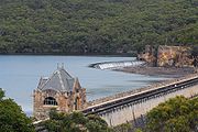
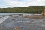
Cataract Dam is a straight dam with an unlined side spillway extending from the left abutment. It is 183 feet (56 m) tall, 811 feet (247 m) long and holds 97,190 ML (2.138×10¹⁰ imp gal; 2.567×10¹⁰ US gal) of water.[1]: 268 Cataract Dam was the first dam built in the Upper Nepean Scheme, it was also first dam in Australia to use pre-cast moulded concrete blocks for the upstream face of the dam. The core of the dam is large (2-4½ ton) sandstone blocks, quarried onsite and cemented together. The downstream face is of mass poured basalt concrete, with a basalt facing. A readily accessible source of suitable rock was located some distance away at Sherbrooke, also known as Ferndale, situated near the top of Bulli Pass. To transport the basalt from the quarry to the dam construction site, a 2 ft (610 mm) gauge steam tramway, 8.8 km (5.5 mi) long, was constructed.[22] Dam construction began in 1902 and was completed in 1907, and the spillway was widened in 1915.[1]: 27–28 Ernest Macartney de Burgh was the supervising engineer for the project from 1904.[23] Poet Banjo Paterson wrote a satirical ballad "The Dam that Keele Built" about the politics behind the construction of Cataract Dam.[24]
Historical Register.[25]
Cordeaux Dam[edit]

Cordeaux Dam is a curved dam with an unlined side spillway on the left abutment. It is 58 metres (191 ft) high, 404 metres (1,327 ft) long and holds 93,640 ML (20,597×106 imp gal). Construction began in 1918 and was completed in 1926.[1]: 268 [26][27] The wall consists of large sandstone blocks, quarried onsite and cemented together, faced with a combination of bluestone and sandstone concrete.[1]: 28–29 The blue metal used in the construction of the dam was supplied from the Government Quarries at Kiama and brought by rail to Douglas Park. From here it was conveyed by aerial ropeway across the Nepean Gorge to an interchange on the eastern side where the material was transferred to a 2 ft (610 mm) gauge steam tramway to a point adjacent to the dam site.[28][29]
Avon Dam[edit]


Avon Dam is a curved dam; it is 72 metres (237 ft) tall, 221 metres (725 ft) long and holds 2.1436×10⁵ ML (47,153×106 imp gal). It has the largest capacity of all the dams in the Scheme. Construction began in 1921 and was completed in 1927.[1]: 268 [30] The dam construction and materials are the same as Cordeaux.[1]: 29 All materials for construction were transported from Bargo railway station on a specially built road, all the other dams in the scheme used rail transport.[26] There were some light tramways constructed at the dam site, however it would appear that no locomotives were employed; skips and other items being moved by winch, horse or manpower.[31]
Nepean Dam[edit]


Nepean Dam is a curved dam; it is 269 feet (82 m) tall and 709 feet (216 m) long. Construction on the Dam began in 1926, construction was delayed for two years during the Depression, it was finally completed in 1935.[1]: 268 [32] The capacity is listed variously as 17,898×106 imp gal (81,370 ML; 2.1495×10¹⁰ US gal)[1]: 268 and 67,730 ML (1.490×10¹⁰ imp gal; 1.789×10¹⁰ US gal).[32]
Railway sidings were established on the Main Southern Line at a point between Bargo and Yerrinbool. Transport to the dam site was again by light railway, on this occasion of standard gauge. This avoided transhipment from the Government vehicles bringing materials from large commercial quarries, effectively making the line an extended privately owned siding. The line was 4 km (2.5 mi) long through gentle countryside. Trains were worked by a variety of locomotives, including a former Sydney Steam Tram Motor. Additionally, there was a system of narrow (610 mm / 2 ft) gauge lines in use at the dam construction site.[33][34]
Additional work was carried out on the spillway between 1943 and 1947 to prevent scouring of the dam foundations.[1]: 31
Shoalhaven[edit]
- System SCA site
- pipes from Nepean to Avon, Avon to Cordeaux for feeding back/on to something ?
- additions made by the Shoalhaven Scheme feeding into the Wingecarribee Reservoir[35]
- History of Sydney Water[2]
Gallery[edit]
-
 Cataract reservoir at full capacity, discharging through spillway
 -
 Detail of Cataract Dam spillway
 -
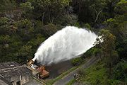 Outlet works at Cataract Dam


Notes[edit]
- ^ a b c d e f g h i j k l m n o Aird, W. V (1961), The Water Supply, Sewerage and Drainage of Sydney (PDF), Metropolitan Water Sewerage and Drainage Board
- ^ a b c d e F.J.J. Henry (1939). The water supply and sewerage of Sydney (pdf). Metropolitan Water Sewerage and Drainage Board. pp. 45–47.
- ^ "SYDNEY WATER SUPPLY WORKS". The Sydney Morning Herald. No. 13, 958. 23 December 1882. p. 6. Retrieved 25 April 2017 – via National Library of Australia.
- ^ "SYDNEY WATER, SUPPLY WORKS". The Sydney Morning Herald. No. 14, 412. 5 June 1884. p. 8. Retrieved 25 April 2017 – via National Library of Australia.
- ^ "The Sydney Herald, WITH WHICH IS INCORPORATED THE COLONIST". The Sydney Herald. Vol. XII, , no. 1365. New South Wales, Australia. 4 October 1841. p. 2. Retrieved 1 May 2017 – via National Library of Australia.
{{cite news}}: CS1 maint: extra punctuation (link) - ^ "THE AUSTRALASIAN SUGAR COMPANY". The Sydney Monitor And Commercial Advertiser. Vol. XVI, , no. 1968. New South Wales, Australia. 1 October 1841. p. 2 (MORNING). Retrieved 1 May 2017 – via National Library of Australia.
{{cite news}}: CS1 maint: extra punctuation (link) - ^ Sarah Trevor (15 August 2013). "Dictionary of Sydney's Cooks River project". Inside History magazine.
- ^ "Damming the Cooks River". dictionaryofsydney.org.
- ^ "ORIGINAL CORRESPONDENCE". The Australian. Vol. IX, , no. 1139. New South Wales, Australia. 20 July 1842. p. 2. Retrieved 1 May 2017 – via National Library of Australia.
{{cite news}}: CS1 maint: extra punctuation (link) - ^ "SWP Applications Template". Sydney Water. Retrieved 1 April 2016.
- ^ "NEWS FROM THE INTERIOR. (From our own Correspondent.) WEST BARGO". The Sydney Morning Herald. Vol. XXXII, no. 4618. 3 March 1852. p. 2. Retrieved 23 April 2017 – via National Library of Australia.
- ^ "GREAT SOUTH ROAD". The Sydney Morning Herald. Vol. XXX, no. 4263. 14 January 1851. p. 2. Retrieved 23 April 2017 – via National Library of Australia.
- ^ "Pheasants Nest Weir (Nepean River) | NSW Environment & Heritage". www.environment.nsw.gov.au.
- ^ "Broughtons Pass Weir | NSW Environment & Heritage". www.environment.nsw.gov.au.
- ^ Allen, Andrew (25 September 2012). "The History Buff: The Upper Canal". The History Buff.
- ^ "Upper Canal System". www.environment.nsw.gov.au.
"Sydney Water Supply Upper Canal".
"Upper Canal System (Broughton Weir to Prospect Reservoir)".
"Upper Canal Water Supply System".
"Upper Canal Water Supply System". - ^ "MASONIC". The Sydney Morning Herald. No. 21, 457. 26 October 1906. p. 10. Retrieved 25 April 2017 – via National Library of Australia.
- ^ "THE WATER WE DRINK". Evening News. No. 12, 959. 21 December 1908. p. 6. Retrieved 25 April 2017 – via National Library of Australia.
- ^ "A RECORD SYPHON". The Cumberland Argus and Fruitgrowers' Advocate. Vol. XXI, , no. 1627. New South Wales, Australia. 14 July 1909. p. 2. Retrieved 25 April 2017 – via National Library of Australia.
{{cite news}}: CS1 maint: extra punctuation (link) - ^ "Proposal to Landmark the Cataract Dam as a National Engineering Landmark" (PDF). Engineers Australia.
- ^ "Register of Large Dams in Australia" (Excel (requires download)). Dams information. Australian National Committee on Large Dams. 2010. Retrieved 11 March 2014.
- ^ Construction Railways of the Upper Nepean Dams - Cataract Dam Longworth, Jim Australian Railway Historical Society Bulletin, July, 1993 pp163-174
- ^ J. M. Antill (1981). "De Burgh, Ernest Macartney (1863 - 1929)". Australian Dictionary of Biography, Volume 8. MUP. p. 266. Retrieved 2007-04-22.
- ^ "Cataract Dam - Sydney Catchment Authority". Retrieved 11 March 2012.
- ^ "Cataract Dam". www.environment.nsw.gov.au.
"Cataract Dam".
"Cataract Dam". - ^ a b "Cordeaux Dam - Sydney Catchment Authority". Archived from the original on 12 July 2009. Retrieved 11 March 2012.
- ^ "Cordeaux Dam". WaterNSW.
- ^ Construction Railways of the Upper Nepean Dams - Cordeaux Dam Longworth, Jim Australian Railway Historical Society Bulletin, October, 1993 pp249-259
- ^ "Cordeaux Dam | NSW Environment & Heritage". www.environment.nsw.gov.au.
- ^ "Avon Dam - Sydney Catchment Authority". Retrieved 11 March 2012.
- ^ Construction Railways of the Upper Nepean Dams - Avon Dam Longworth, Jim Australian Railway Historical Society Bulletin, January, 1994 pp14-19
- ^ a b "Nepean Dam - Sydney Catchment Authority". Retrieved 11 March 2012.
- ^ Construction Railways of the Upper Nepean Dams - Nepean Dam Longworth, Jim Australian Railway Historical Society Bulletin, May, 1994 pp137-153
- ^ "Nepean Dam | NSW Environment & Heritage". www.environment.nsw.gov.au.
- ^ "GREATER SYDNEY'S WATER SUPPLY SYSTEM" (PDF). Sydney Water. Retrieved 21 April 2017.
References[edit]
- Sydney Catchment Authority. Upper Nepean Dams
- Hudsons http://www.waternsw.com.au/supply/Greater-Sydney/heritage/water-schemes/upper-nepean-scheme-anniversary/rescued-by-the-hudsons-temporary-scheme
- WaterNSW - "Celebrating 125 years of the Upper Nepean Scheme" (pdf). WaterNSW. Retrieved 27 March 2016.