User:Bangiomorpha/Square Charles II
Place Charles II
Place de la Ville Haute | |
|---|---|
| City square | |
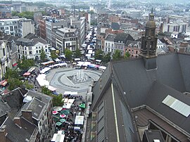
 View of the square from the belfry on market day. | |
| Surface | 6500 sqm |
| Dedicated to | Charles II |
| Location | Charleroi, Belgium |
 Click on the map for a fullscreen view | |
| Coordinates (Square): 50°24′42″N 4°26′40″E / 50.411650°N 4.444552°E | |
The place Charles II, "square Charles II", is the historical heart of the city of Charleroi, formerly the place-of-arm of the fortress founded in 1666.
Charles II was king of Spain and the Netherlands at the time of its foundation. Commonly called place de la Ville-Haute, "square of the upper city", it received its name only in 1912[1]. It is also known as place des jets d'eau, "square of the fountains", after the installation of fountains.
History[edit]
The square retains the hexagonal layout of the Spanish fortress, which was inspired by the ideal Renaissance model applied to Palmanova (1593), currently in Italy.
This plan was intended to allow easy movement for troops between the center and the bastions. Six streets led to the six bastions. Streets parallel to the sides of the square delimit the built-up areas. Every other block, those reserved for housing, has a street, two of which lead to gates. The Brussels gate to the north, the French gate to the southwest. The building of the square has evolved while keeping the layout of the initial project.
In the 19th century, this square was the place where executions were organized for the death penalty. In 1862, some members of the Bande Noire, "Black Gang", were beheaded here, and more than 20,000 people attended the execution by guillotine of Auguste Leclercq and Jean-Baptiste Boucher[2].
In the second half of the 20th century, the square became a traffic circle and a parking area. In the 1990's, the renovation of the square allowed to highlight its hexagonal layout.
-
Relief plan from the 1696 survey. Upper town seen from the west.
-
Charles II square and adjacent streets. In blue, the fortress of 1666, now destroyed.
Note[edit]
Bibliography[edit]
Jean Everard, Monographie des rues de Charleroi, Charleroi, Collins, 1959, 223 p., In-12.
Philippe Mac Kay, Marianne Bruneau and Denis Gauvain, Charleroi d'hier et d'aujourd'hui : Rue par rue, Charleroi, " Un dossier de La Nouvelle Gazette ", October 1996
Alexandra Vanden Eynde, Cédric Swennen, Nicolas Rochet, Carnet des villes de Charleroi, Liège & Namur, Charleroi, Espace Environnement, " Septentrion, de la ville forte à la ville durable ", 2006, 67 p., p. 5-26.


