
User:B137/Ballad
Biscayne Blvd is a main north south east or affair in Miami-Dade County, Florida. It is signed as US Route 1 for its entire length. In Downtown Miami it turns into Brickell Avenue to the south. Its northern terminus is at the Broward County line where it becomes Federal Highway.
Downtown Miami[edit]
Other versions[edit]
Copy from US1/Florida[edit]
For the first 14 miles (23 km) in Miami-Dade County, US 1 is a divided two-lane road bordering the Everglades National Park on the west. It is named South Dixie Highway from the county line to Miami. Its first major intersection is with the north end of Card Sound Road south of Florida City. Similarly to the south, signage directs southbound travelers approaching this intersection to take Card Sound Road if the lights on it are flashing, rather than taking US 1 south to Key Largo.

Just north of the Card Sound Road intersection, US 1 meets the southern end of Krome Avenue (State Road 997), and then enters Florida City. Here, US 1 intersects State Road 9336, providing access westwards to Everglades National Park; at the same intersection, Palm Drive (former State Road 906) likewise provides access eastwards to Biscayne National Park. From here northbound, the South Dixie Highway is paralleled by the South Miami-Dade Busway along the former Florida East Coast Railway alignment. Near-immediately northbound of the Palm Drive intersection, US 1 meets the southern end of the Homestead Extension of Florida's Turnpike, and then crosses into Homestead at South 328th Street.[1] The road then curves northeast through Homestead, parallel to Florida's Turnpike, leaving the city north of South 304th Street, continuing northeast through the communities of Leisure City, Modello, Naranja, Princeton, and Goulds.
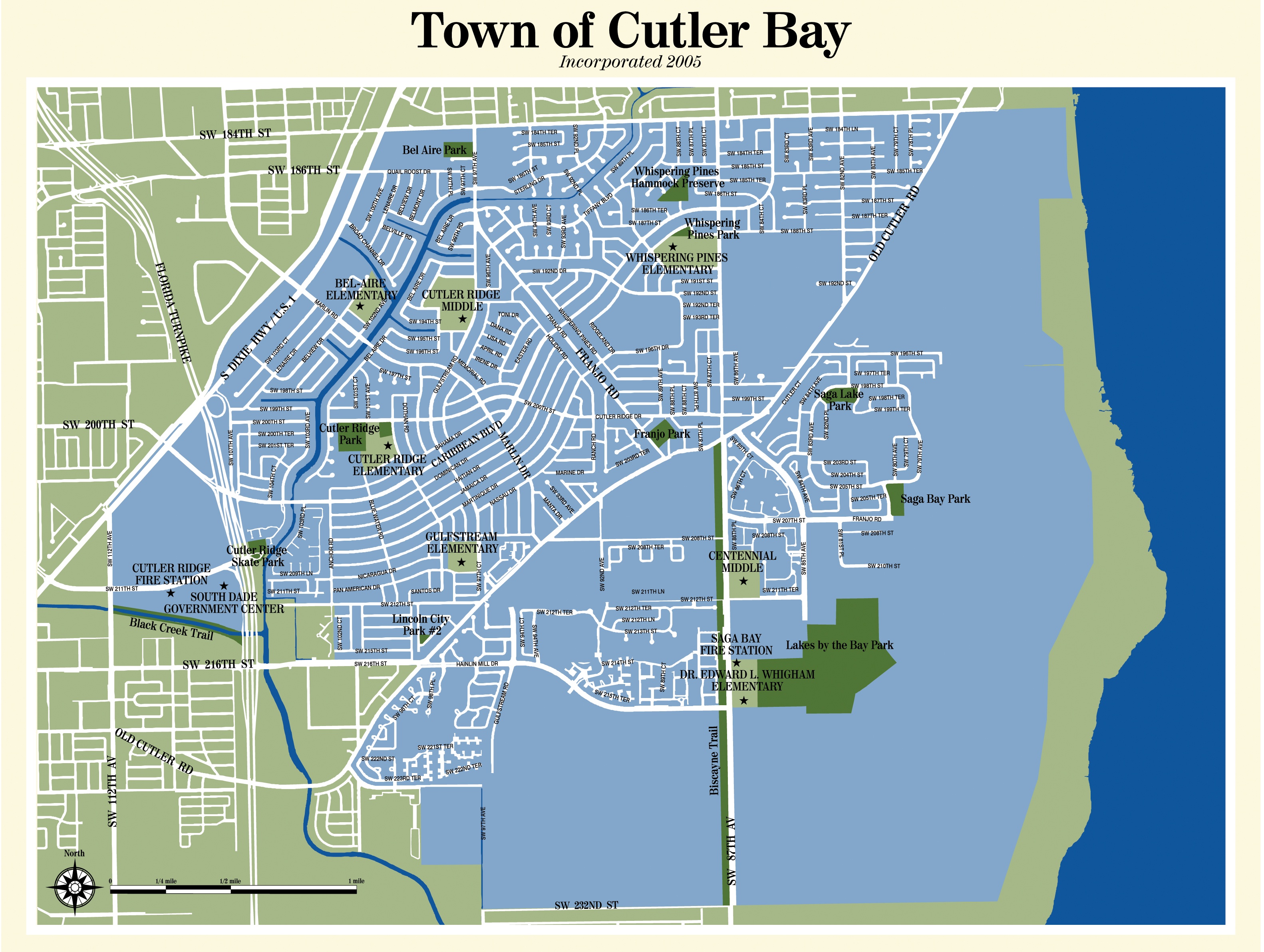
At West 112th Avenue/Allapattah Road (SR 989), US 1 enters the incorporated town of Cutler Bay (formerly Cutler Ridge), soon passes under the Homestead Extension of Florida's Turnpike, and continues northeast in the town until at South 186th Street it forms the town's border for two blocks before leaving at South 184th Street.[2] From here, the road continues northeast from this point, forming the western boundary of Palmetto Bay.[3] In Perrine, it meets State Road 994, and then divides into a one-way pair of streets, with northbound traffic directed east one block of the southbound traffic along a sweeping curve between South 183rd and South 168th Streets. After the two directions of traffic rejoin, the road meets Coral Reef Drive (SR 992), then passes though Rockdale and Howard until it reaches South 136th Street (Howard Drive), meets the southern terminus of State Road 973 a block later, and serves to divide Pinecrest to the southeast and Kendall and Dadeland to the northwest for the next few miles. The road is also known as Pinecrest Parkway through this section.[4] Also through this section, US 1 meets the eastern terminus of State Road 990, the southern terminus of the Palmetto Expressway (State Road 826), and the eastern terminus of State Road 94 at Kendall Drive.
North of Snapper Creek (Canal C-2), US 1 continues northeast and enters another section of unincorporated Miami-Dade County. Here, US 1 forms the Snapper Creek Expressway's (State Road 878)'s eastern terminus. The Dadeland South Metrorail station lies just south of the Expressway, on US 1's northern side, and acts as the handover point between the South Miami-Dade Busway and the Metrorail line, which proceeds to parallel US 1 for most of its subsequent journey into downtown Miami. The South Dixie Highway then crosses into South Miami at South 80th Street.[5] At State Road 959 (Red Road/West 57th Avenue), US 1 leaves South Miami and enters Coral Gables, still headed northeast.[6] At West 38th Avenue (Brooker Street), it leaves Coral Gables and enters Miami, heading northeast towards the southern terminus of Interstate 95 just south of downtown Miami. Until 2014, US 1 became Brickell Avenue. As of June 2013, FDOT has agreed to relinquish Brickell Avenue to the city of Miami in a swap for other local roads.[7] In October 2013, AASHTO approved a re-location of US 1 along the Downtown Distributor (SR 970) and I-95.[8]

In Miami, US 1 first intersects State Road 976, followed by the south end of State Road 9, which ends up running concurrent with Interstate 95, and is also I-95's state designation through most of Florida. About a mile east, it meets the national southern terminus of I-95, which is joins over the Miami River into downtown.

The road is then named Biscayne Boulevard through the rest of Miami-Dade County as it proceeds north on Biscayne Bay. As Biscayne Boulevard, US 1 becomes a one-way pair at an intersection with State Road 970. Two blocks north, it reaches State Road 968 (Flagler Street), the north-south baseline for most of Miami-Dade County. US 1 then passes by the western end of Bayfront Park, and then intersects Port Boulevard (NE 6th Street), providing access to the Port of Miami, with the American Airlines Arena at the northeastern end of the intersection. For the next few blocks, it passes by Bicentennial Park, with Interstate 395 at the northern end, which also marks the national southern terminus of US 41. US 1 continues through midtown Miami, intersecting with the national southern terminus of U.S. Route 27 one block south of Interstate 195 next to the Julia Tuttle Causeway. North of I-195, the road continues through Miami as a residential road, intersecting State Road 944, State Road 934, and State Road 915 before leaving Miami. Moving further inland, the Boulevard replaces East Sixth Avenue at 61st Street. It enters the village of Miami Shores at North 87th Street. Crossing the Biscayne Canal, Miami Shores becomes North Miami. In North Miami, it intersects State Road 922, leading to the Broad Causeway and State Road 916. In North Miami Beach, it intersects State Road 826, and State Road 860. The road enters Aventura at Greynolds Park. It continues north-northeast through the city of Aventura, curving due north at North 187th Street and northeast at North 203rd Street. In Aventura, it intersects State Road 856 at the southwest of the Aventura Mall, and after intersecting the former State Road 854, it leaves Miami-Dade County.
Biscayne Wall[edit]

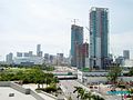
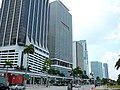
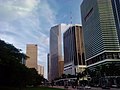
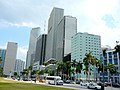
The Biscayne Wall refers to a linear series of skyscrapers on the west side of Biscayne Boulevard in Downtown Miami, Florida, United States.[9] The "Biscayne Wall" begins at the Met 1 tower in the Central Business District and ends with the Marquis Residences tower to the north in Park West.
List of buildings comprising the Biscayne Wall[edit]
- Met 1, 300 Block South
- Southeast Financial Center, 200 Block South
- One Bayfront Plaza, 100 Block South
- One Biscayne Tower, 2 South Biscayne Boulevard
- New World Tower, 100 North Biscayne Boulevard
- 50 Biscayne, 50 North Biscayne Boulevard
- Vizcayne, 200 Block North
- Freedom Square, 600 Block North
- Paramount Park, 700 Block North
- Marinablue, 800 Block North
- 900 Biscayne Bay, 900 Block North
- Ten Museum Park, 1000 Block North
- Marquis Residences, 1100 Block North
-
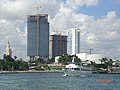
 Construction of the Biscayne Wall in downtown Miami in October 2006
 -
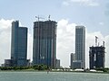
 Construction progress of the northern portion of the Biscayne Wall on 1/20/2007
 -
 Construction progress of the northern portion of the Biscayne Wall on 5/25/2007
 -
 Construction progress of the northern portion of the Biscayne Wall on 2/23/2008
 -
 Construction progress of the northern portion of the Biscayne Wall on 3/28/2008
 -
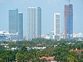
 View from south end of the wall looking north 5/10/2008
 -
 Southern end of the wall.
 -
 South end


References[edit]
- ^ Land Use Map of Homestead
- ^ Map of Cutler Bay
- ^ General Highway Map - Miami-Dade County, Florida (PDF) (Map) (May, 2010 ed.). Surveying and Mapping Office, Florida Department of Transportation. April, 2007. Retrieved April 03, 2013.
{{cite map}}: Check date values in:|accessdate=and|date=(help) - ^ Vision Internet, ed. (2013). "Village of Pinecrest, Florida : Street Name Origins". Village of Pinecrest. Retrieved April 21, 2013.
- ^ South Miami city map
- ^ City of Coral Gables Map
- ^ City of Miami Legislation Resolution. File Number: 13-00581
- ^ [1]
- ^ The Real Biscayne Wall
25°46′58″N 80°11′22″W / 25.782696°N 80.189466°W
wikimedia valued images[edit]
<nonwiki>
Ballad
{{VIC |subpage=Ballad |image=Ballad |date={{subst:VI-time}} |nominator=B137 (talk) |scope=Iron trestle bridges |orientation=landscape |usedin=en:Portage Viaduct |status=nominated |reason=Bridge will likely be demolished |review= }} </nonwiki>