User:Aqwis/Ytrebygda
Ytrebygda bydel | |
|---|---|
Borough of Bergen | |
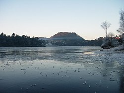
 Skranevannet at Sandsli, Ytrebygda | |
| Coordinates: 60°17′13.7466″N 5°16′12.0144″E / 60.287151833°N 5.270004000°E | |
| Country | Norway |
| City | Bergen |
| Borough ID | NO-120106 |
| Area | |
| • Total | 39.61 km2 (15.29 sq mi) |
| • Rank | Ranked 4 in Bergen |
| Population (2009) | |
| • Total | 24,760 |
| • Rank | 7 |
| • Density | 630/km2 (1,600/sq mi) |
| • Percent of total | 9.82% |
Ytrebygda is a borough of the city of Bergen, Norway. It is located south-west in the city, on a peninsula between Nordåsvannet and Grimstadfjorden, and Fanafjorden. As of January 1, 2009, Ytrebygda had a population of 24,760, and it is experiencing strong population growth. It has several important industries, including the business/industrial park at Kokstad and Sandsli and Bergen Airport, Flesland.
Prior to 1989, Ytrebygda was part of Fana borough, which before 1972 had been a seperate municipality. Fana has been settled at least since the Middle Ages, but it was primarily an agricultural district until the 20th century. In the 16th century, Fana, which also included what today is Fyllingsdalen borough, had an approximate population of 700. The area which makes up Ytrebygda borough was, too, agricultural; the little industry that existed included a glass works at Flesland.
Ytrebygda is located over 10 km from the city centre of Bergen, and as the vast majority of the inhabitants rely on a car for personal transport, and not the bus system, Ytrebygda has the lowest public transport usage in Bergen. An extension of the Bergen Light Rail line is planned to Bergen Airport, Flesland, which would also have several stops in residential areas in Ytrebygda. The main roads connecting the borough to the rest of Bergen are Flyplassvegen and Fritz C. Riebers veg (E39), and Ytrebygdsvegen.
History[edit]
Prior to 1989, Ytrebygda was part of Fana borough, which before 1972 had been a seperate municipality.
Ytrebygda was created as a borough in 1989. Prior to this time, it had been part of Fana borough. The origin of Fana borough was Fana municipality, which, along with the municipalities of Åsane, Arna and Laksevåg, was merged with Bergen in 1972. Fana is known to have been settled at least since the Middle Ages, but it was primarily an agricultural district until the 20th century. In the 16th century, Fana, which also included what today is Fyllingsdalen borough, had an approximate population of 700. The area which makes up Ytrebygda borough was, too, agricultural; the little industry that existed included a glass works at Flesland.
Geography[edit]
- Climate
Demography[edit]
Economy[edit]
Landmarks[edit]
Transport[edit]
A western ring road between Ytrebygda and Laksevåg is under construction. It will be of motorway standard and will eventually connect to the RV 555 motorway in Laksevåg, allowing for quick travel between Ytrebygda and the city centre of Bergen, Laksevåg and Åsane, while avoiding European route E39 and Danmarks plass.
Culture[edit]
Education[edit]
References[edit]


