|
|
| Andes |
|---|
 | |
| Peak | Aconcagua, Las Heras Department, Mendoza, Argentina |
|---|
| Elevation | 6,962 m (22,841 ft) |
|---|
| Coordinates | 32°39′10″S 70°0′40″W / 32.65278°S 70.01111°W / -32.65278; -70.01111 |
|---|
|
| Length | 7,000 km (4,300 mi) |
|---|
| Width | 500 km (310 mi) |
|---|
|
| Native name | Antisuyu Error {{native name checker}}: parameter value is malformed (help) |
|---|
|
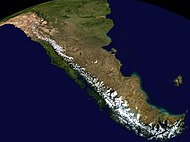 Composite satellite image of the southern Andes
| | Countries | Argentina, Bolivia, Chile, Colombia, Ecuador, Peru and Venezuela |
|---|
| Settlements | Bogotá, Santiago, Medellín, La Paz, Cali, Quito, Pasto, Mérida, Arequipa, Mendoza, Cuenca, Cochabamba, Pereira, Ibagué, Salta, Manizales, Cúcuta, Cusco and Bucaramanga |
|---|
|
| Andes |
|---|
| |
| Peak | Aconcagua, Las Heras Department, Mendoza, Argentina |
|---|
| Elevation | 6,962 m (22,841 ft) |
|---|
| Coordinates | 32°39′10″S 70°0′40″W / 32.65278°S 70.01111°W / -32.65278; -70.01111 |
|---|
|
| Length | 7,000 km (4,300 mi) |
|---|
| Width | 500 km (310 mi) |
|---|
|
| Native name | Antisuyu Error {{native name checker}}: parameter value is malformed (help) |
|---|
|
Composite satellite image of the southern Andes
| | Countries | Argentina, Bolivia, Chile, Colombia, Ecuador, Peru and Venezuela |
|---|
| Settlements | Bogotá, Santiago, Medellín, La Paz, Cali, Quito, Pasto, Mérida, Arequipa, Mendoza, Cuenca, Cochabamba, Pereira, Ibagué, Salta, Manizales, Cúcuta, Cusco and Bucaramanga |
|---|
|
|


