
Tay Street
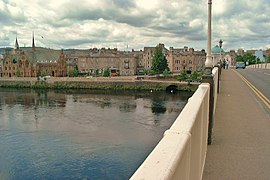
 Tay Street, viewed from Bridgend in 2015 | |
 Location within Perth | |
| Part of | A989 |
|---|---|
| Length | 0.47 mi (0.76 km) |
| Location | Perth, Perth and Kinross, Scotland |
| North end | West Bridge Street and Charlotte Street |
| Major junctions | High Street South Street Canal Street |
| South end | Marshall Place and Shore Road |
| Construction | |
| Completion | c. 1870 |

Tay Street is a major thoroughfare, part of the A989, in the Scottish city of Perth, Perth and Kinross. Planned in 1806 and completed around 1885, it is named for the River Tay, Scotland's longest river, on the western banks of which it sits. The street runs from the confluence of West Bridge Street and Charlotte Street in the north to a roundabout at Marshall Place and Shore Road in the south. Three of the city's four bridges that cross the Tay do so in this stretch (from north to south): Perth Bridge (also known as Smeaton's Bridge), Queen's Bridge and the single-track Tay Viaduct, carrying Perth and Dundee trains to and from Perth railway station, located 0.5 miles (0.80 km) to the north-west.[1]
Thomas Hay Marshall and his father-in-law, Thomas Anderson (owner of the former Blackfriars lands), who were responsible for the construction of much of Georgian Perth, made the first steps in the creation of Tay Street in the late 18th century when they constructed Atholl Crescent and Atholl Street in the north and Marshall Place in the south.[2] The sections in between were gradually filled in over the course of the next century.
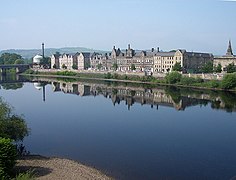
"A curving line of elegant buildings,"[3] Tay Street links the city's two main parks, the North Inch and the South Inch.
Water Vennel, one of Perth's many vennels, leads between Tay Street and Watergate.
Notable buildings[edit]

.jpg)
Located along the western side of the street's 0.47 miles (0.76 km) course are several notable buildings dating from the 19th century, designed by several of Scotland's leading architects. The below, ordered from north to south, are all listed structures at Historic Environment Scotland.[5]
- 2 Tay Street
- Royal George Hotel – has an entrance from Tay Street
- Former Middle Church and halls, 4–6 Tay Street
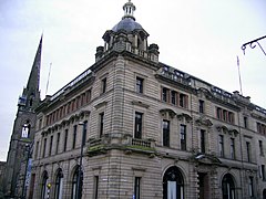
- Municipal Buildings, 1–5 High Street and 8–18 Tay Street
- 2 High Street – has an entrance from Tay Street
- St Matthew's (formerly West) Church
- 26 Tay Street – formerly Perth Savings Bank
- Victoria Buildings, 36–44 Tay Street
- "Gowrie House", 46–52 Tay Street
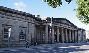
- Sheriff Court, former site of Gowrie House, 46–52 Tay Street
- County Buildings, 62–72 Tay Street
- Perth Water Works, now The Fergusson Gallery; address is Marshall Place, but it its eastern elevation is on Tay Street
Although not a listed structure, situated immediately to the north of the railway bridge is the former Volunteer Drill Hall.[6]
Perth Baptist Church formerly stood at the southern corner of Tay Street and Canal Street. Built on the site of Perth Opera House, it was destroyed in a fire in 1984. A modern building now stands in its place. The Baptists moved a new building in the Letham area of the city.[7]
Architects[edit]
Robert Smirke designed the Sheriff Court and County Buildings, which were built in 1819.[6]
Glasgow's John Honeyman designed St Matthew's Church, by far the most prominent structure on the street, erected in 1871.[8]
Perth architect Andrew Heiton was responsible for 26 Tay Street, completed around 1873,[9] the Victoria Buildings, dating to 1872,[10] 46–52 Tay Street (possibly), completed in 1870,[11] and the municipal building that runs between 8 and 18 Tay Street, which were built in 1881.[12]
David Smart designed the building at 1–3 South Street, at the corner of Tay Street, which was built between 1863 and 1866.[13] His office was located in the Victoria Buildings at 42 Tay Street.[14]
John Young's effort was Perth's former museum building, built between 1879 and 1881, which backs up to the Greyfriars Burial Ground. The building was extended in 1895, and a fire in 1987 resulted in the northern end being demolished and rebuilt.[15]
George Penrose Kennedy Young designed the municipal building at the corner of 2 High Street, which was erected in 1899.[16] His firm also designed the extension of the fire-damaged Perth Museum.[15]
Images[edit]
-
 Tay Street in a 1903 postcard
 -
 The northern end of Tay Street, viewed from Perth Bridge
 -
 Municipal building at 8–18 Tay Street
 -
 2 High Street
 -
 St Matthew's Church, roughly in the middle section of Tay Street
 -
 Perth Bridge in view at the northern end of the street
 -
 View from Perth Bridge
 -
 Queen's Bridge, looking between the Sheriff Court and 1–3 South Street
 -
 Perth's Sheriff Court
 -
 62–72 Tay Street, formerly the home of Perth Museum
 -
 Former Perth Water Works building, now a gallery for the art of J. D. Fergusson
.jpg)


.jpg)

References[edit]
- ^ Bridges of Perth Archived 16 October 2007 at the Wayback Machine
- ^ Civic History of Perth from Medieval Times – Perth Civic Trust
- ^ Official Guide to Perth and Its Neighbourhood by the Tramway Car Routes – Perth Town Council (1907), p. 16
- ^ "Kinnoull Conservation Area Appraisal" – Perth and Kinross Council
- ^ Tay Street – Historic Environment Scotland
- ^ a b Ordnance Gazetteer of Scotland: A Graphic and Accurate Description of Every Place in Scotland, Francis Hindes Groome (1901)
- ^ Parth Baptist Church – Places of Worship in Scotland
- ^ Historic Environment Scotland. "St Matthew's (formerly West) Church, Tay Street (Category B Listed Building) (LB39312)". Retrieved 17 April 2020.
- ^ Historic Environment Scotland. "Tay Street, 26, Savings Bank (Category B Listed Building) (LB39655)". Retrieved 17 April 2020.
- ^ Historic Environment Scotland. "Tay Street, 36-44 Victoria Buildings (Even Numbers) (Category B Listed Building) (LB39656)". Retrieved 17 April 2020.
- ^ Historic Environment Scotland. "Tay Street, 46–52 "Gowrie House" (even numbers) (Category B Listed Building) (LB39657)". Retrieved 1 March 2022.
- ^ Historic Environment Scotland. "Municipal Buildings, 1, 3, 5 High Street, 8, 10, 11, 12, 13, 14, 15, 16, 18 Tay Street (One Continuous Design) (Category B Listed Building) (LB39320)". Retrieved 17 April 2020.
- ^ Historic Environment Scotland. "1, 3 South Street and 54 Tay Street, Tay Purification Board (Category B Listed Building) (LB39333)". Retrieved 17 April 2020.
- ^ David Smart - Dictionary of Scottish Architects
- ^ a b Historic Environment Scotland. "62-72 (Even Nos) Tay Street, including former museum (Category B Listed Building) (LB39658)". Retrieved 17 April 2020.
- ^ Historic Environment Scotland. "High Street And Corner Of Tay Street, General Accident Fire And Life Assurance Corporation, World Headquarters (Category B Listed Building) (LB39469)". Retrieved 17 April 2020.
External links[edit]
- "PERTH WALK, Scotland Walking Tour in 4K" – Tay Street portion