
Talk:Territorial evolution of the United States/Archive 5
| This is an archive of past discussions. Do not edit the contents of this page. If you wish to start a new discussion or revive an old one, please do so on the current talk page. |
| Archive 1 | ← | Archive 3 | Archive 4 | Archive 5 | Archive 6 | Archive 7 |
Requests
Golbez, I've looked over what you have done so far with the rewrite of Territorial Evolution of the U.S., and I am amazed. Your work is outstanding, even heroic! I think the result is going to be a big, big leap up.
Would now be a good time to offer a few observations and suggestions? I’d like to offer up the following and would like to know what you think.
(1) I'd like to suggest having one map for the bancos exchanged on the Arizona border in 1927. I took a screenshot and drew in the boundaries of the two bancos, so there would be no need to locate them on your own. I’ve shared the file at this address: https://drive.google.com/file/d/0B9LDb9lFYjVPUEh6MEVzQlJHZWM/view?usp=sharing
(2) I'd also like to suggest a map for the Rio Grande rectification in the 1930s, as it involved the largest land transfer along that river since 1846. I've mentioned previously a map that appears in Mueller's book. I've scanned it and shared it here: https://drive.google.com/file/d/0B9LDb9lFYjVPTlhyOUhTV2ItTUE/view?usp=sharing
The above two situations stand out as notable in my opinion. I don't know how difficult it would be to create maps based on these graphics, but I offer them up in case you find them useful.
(3) Also, for the date of annexation of West Florida, I believe the date of December 10, 1810, should be used, instead of the date of Madison's proclamation. He proclaimed that "possession should be taken," and then dispatched Claiborne to accomplish it, a task which was completed on 12/10/1810. Claiborne conducted a formal transfer ceremony on that day with the West Florida troops that surrendered at the fort in Baton Rouge, including the respectful lowering of the West Florida flag.
(4) Back to the Louisiana Purchase, the first handover to the U.S. that occurred in December, 1803, was the handover of the Territory of Orleans only. The turnover of Upper Louisiana occurred in St. Louis on Three Flags Day on March 10, 1804.
(5) Last, I have found several sources, including scholarly ones, that state that Spain changed the eastern border of West Florida in 1785 by pushing it further east to the Suwannee River. Here are the citations: [1][2] [3][4] Also see image at https://commons.wikimedia.org/wiki/File:1822_Geographical,_Statistical,_and_Historical_Map_of_Florida_by_Henry_Charles_Carey,_Isaac_Lea_and_Fielding_Lucas.png
What are your thoughts?Jeff in CA (talk) 04:10, 9 February 2016 (UTC)
- 1) I really am trying to get away from mapping tiny riverine changes, but this one might qualify as important enough, since it happened in a city. Fine, adding to list.
- 2) This one, however... a bunch of tiny changes in a 2 mile stretch that would be mapped simply by me tracing that picture? Urgh, except the picture's not PD, so I can't just link to it. So I'd have to redo it. Hrrm. Well since the work is already done I guess there's no harm in it. But don't take this to mean I'm adding all bancos! Adding to list.
- 3) Indeed, he does says possession "should be taken". I'll add this to the todo list.
- 4) I'm unsure on this one. The article on Three Flags Day says that the whole of Louisiana was ceded on Dec 20 1803, and that the ceremony of March 10 1804 might have been purely symbolic. (since presumably St Louis didn't have the authority to reject the deal?) On the other hand, that brings to question whether the ceremonies for East and West Florida should be considered. Hm. I mean, I'm absolutely add an entry for March 10 1804; the story is really interesting, and worth noting. But I'm still debating whether or not to split the map... As far as the authorities in New Orleans were concerned, they were transferring the whole of Louisiana, not just Orleans District, so while important in terms of communication (since news moved very slowly back then), from a purely geopolitical point of view I'm not sure they should be split up. I mean, to do that might imply that any remote outpost should get its own entry when news of the U.S. transfer comes to town, or when a group of soldiers come in and hoist the flag for the first time. So, after all this: I'll add an entry to the list for the day but no map changes at this point. Unless you can address my concerns. :)
- 5) Sold. Added to list.
- ps, thank you for the kind words, and I absolutely would not have been able to do this without help from especially you and Xavier. (speaking of which, now that the main maps are 99% done... we need to go back and finish up Canal Zone) --Golbez (talk) 21:51, 9 February 2016 (UTC)
- Thank you for adding these items to your list. I think they'll be positive, and I appreciate it. As for No. 4, I'll defer to your research on it. I had not read further down in the Wikipedia article, which seems to contradict the word "official" as used in its intro, probably accurately. On the other hand, for situations such as the turnovers of the Floridas, historians record that such hand-offs signified transfer of title among the powers involved. For example, after the 1762-1763 treaties that transferred the western half of Louisiana from France to Spain, Spain did not take possession, hence acquire title, until 1769, when the second guy they sent to New Orleans succeeded in making it to the official transfer ceremony. I am not well-versed on the 1803-04 transfer ceremonies.
- By the way, on No. 2, the Rio Grande rectification happened over an 86-mile stretch. Also, I'd like to pass along a couple things that I noted in reading in the past few months, but for which I failed to note the source. More investigation is called for as to how the article might be impacted (perhaps there'd be no impact). (a) The agreement of Mexican cession in 1848 made no mention of any of the islands off the entire California coast. The U.S. simply took them anyway, according to one of the books I read. (b) The Soviet Union broke up before it could ratify the Alaska maritime border treaty. I don't know if Russia subsequently took up the treaty. (c) Regarding Popes Folly Is., the NY Times article says the island fell on one or the other side of the mapped border, hence was not split. Had Popes Folly Island been split at an earlier time? Again, I can't put my finger on anything right now to confirm or answer these.
- I'd also be happy to collaborate further on the Canal Zone if there is anything that comes up. Jeff in CA (talk) 02:42, 10 February 2016 (UTC)
- In regards to the islands off the California coast, the Mexican Government in 1947 disavowed that they had maintained any claim over those islands since the 1848 treaty. See here [[1]]. Mexican nationalists unaffiliated with the Mexican government do still assert that the Mexican government does have a claim on the area, but the Mexican government itself has never acknowledged such claims.XavierGreen (talk) 21:14, 10 February 2016 (UTC)
- I'd also be happy to collaborate further on the Canal Zone if there is anything that comes up. Jeff in CA (talk) 02:42, 10 February 2016 (UTC)
- re a: They weren't mentioned, and the treaty does note the border to run to the Pacific Ocean, but the official maps involved in the treaty do apparently show the islands as American. re b: The UN Treaty Series says the treaty took effect June 15, 1990, though it wasn't ratified by the US until September 1991... which is odd to me. re c: I wouldn't have made up the line I drew down Pope's Folly Island but I can't find where... any suggestions on how I should resolve this? --Golbez (talk) 22:02, 10 February 2016 (UTC)
- I found a 1907 USGS map that shows the border crossing Popes Folly Island. Along with it is a 1908 USGS map that shows a changed border that avoids the island. See http://store.usgs.gov/b2c_usgs/usgs/maplocator/(xcm=r3standardpitrex_prd&layout=6_1_61_48&uiarea=2&ctype=areaDetails&carea=%24ROOT)/.do To see the USGS map, zoom in on Popes Folly Island, mark it, click the marker and choose the 1907 map to download. The 1908 U.S.-Great Britain (Canada) border treaty in Article I changed the border through Passamaquoddy Bay to agree with the 1892 survey mentiond in the NY Times article. The 1908 treaty is at https://babel.hathitrust.org/cgi/pt?id=hvd.32044086241809;view=2up;seq=2;size=150 Paragraphs 5 and 6 of Article I specifically address the location of the line with respect to Popes Folly Island, and give rise to the 1910 treaty that was specific to the border in Passamaquoddy Bay. Jeff in CA (talk) 15:43, 12 February 2016 (UTC)
Tense
This is a weird one but, I've tried to write everything in present tense. However, looking back through, this is starting to introduce some tense disagreement, especially in larger days. Should I just shove it all into past tense? --Golbez (talk) 05:14, 24 February 2016 (UTC)
Quita Sueño Bank
I noticed that the working version of the revision states that Quita Sueno Bank was ceded to Colombia in 1981 along with Roncador and Serrana Banks. In actuality the text of the treaty states that the United States abandons its claim to Quita Sueno, as it no longer had any natural emergent land and thus was no longer subject to a sovereignty claim by any nation, it specifically does not acknowledge the Colombian claim over that particular bank as the official opinion of the united states is that the bank is not emergent and therefore not claimable by any country. Therefore I would change the entry on the working version to state that the claim to Quita Sueno was abandoned on that date rather than ceded to Colombia with the other two banks.XavierGreen (talk) 14:08, 28 December 2015 (UTC)
- Added to the to-do list for review. Thank you!! --Golbez (talk) 14:14, 28 December 2015 (UTC)
- With regard to "natural emergent land" vis-a-vis sovereignty claims, what is the defintion of natural emergent land? Does it have to do with the tidal elevation under one of its several specifications (high, mean, low, mean heidi-heidi-ho, ...)? I ask with an eye toward what the U.S. government considers Nunez Rocks in the disputed Dixon Entrance to be. Nunez Rocks are called "bare at half-tide" on a USGS map. Under a 1903 treaty, the U.S. considers the land masses within Dixon Entrance to belong to Canada, but not necessarily the water area. (Canada says the treaty gives it all the water area.) My question: are the Nunez Rocks "land"? Jeff in CA (talk) 20:31, 23 January 2016 (UTC)
- International law holds that areas which are submerged at high tide are not generally the subject of soveriegnty claims under international law. These are called Low Tide Elevations (LTEs) in international law. LTE's cannot by themselves be used for the basis of a sovereignty claim, however they can be used as basepoints for the purposes of maritime claims, so long as they are situated wholly or partly at a distance not exceeding the breadth of the territorial sea from the mainland or an island. Thus they can be used to extend a territorial sea, contiguous zone, or eez claim further outward but if otherwise would be outside of a state's territorial sea, are in effect terra nullis when they are emergent. Uninhabitable rocks and reefs (there is no consensus in the law as to what this means) that are emergent at high tide are subject to sovereignty claims, but cannot be the source of EEZ or other claims further out then the territorial sea surrounding the rock or reef.
- Quita Sueno is not within the territorial sea of any emergent land area, as such it cannot be claimed under international law. As Nunez Rocks appear to be within the territorial sea of the mainland, i would imagine they would be the subject of a sovereignty claim.XavierGreen (talk) 00:57, 28 January 2016 (UTC)
- With regard to "natural emergent land" vis-a-vis sovereignty claims, what is the defintion of natural emergent land? Does it have to do with the tidal elevation under one of its several specifications (high, mean, low, mean heidi-heidi-ho, ...)? I ask with an eye toward what the U.S. government considers Nunez Rocks in the disputed Dixon Entrance to be. Nunez Rocks are called "bare at half-tide" on a USGS map. Under a 1903 treaty, the U.S. considers the land masses within Dixon Entrance to belong to Canada, but not necessarily the water area. (Canada says the treaty gives it all the water area.) My question: are the Nunez Rocks "land"? Jeff in CA (talk) 20:31, 23 January 2016 (UTC)
- XavierGreen, thank you for answering my question. It turns out, as you may know, that the U.S. did declare a territorial sea within Dixon Entrance around 1977 (over Canada's certain disapproval) and used Nunez Rocks as a basepoint, just as you said. It would seem to me, an outsider, that such U.S. action might necessarily correspond to a sovereignty claim. On the other hand, Canada has long asserted its sovereignty over the entire Dixon Entrance, while the U.S. conceded Canada's sovereignty over the land masses only. Would you say, therefore, that there are competing sovereignty claims over Nunez Rocks? Or because it's a LTE, no sovereignty claim to Nunez Rocks would be valid?
- Also, in regard to Quita Sueno Bank, the International Court of Justice ruled in a case between Nicaragua and Columbia a few years ago that one of 32 identified features of the Bank was an island at high tide, with an area of one square meter. Thus, it upheld Columbia's claim to the Bank and a territorial sea around it. However, surrounding that sea area, the ICJ ruled, would be Nicaragua's EEZ. FWIW. Jeff in CA (talk) 04:02, 10 February 2016 (UTC)
- If Nunez Rocks is claimed as a basepoint, the rocks themselves would be claimed as territorial sea by the united states, even when emergent. LTE areas cannot be claimed as emergent land, only as Territory Sea, but territorial sea is still a sovereignty claim (with the cavet of allowing peaceful passage by other states vessels). It would seem then that Canada perhaps claims nunez rocks as emergent land while the US claims them as territorial sea? We would need sources to confirm this though. In regards to Quita Sueno, the ICJ case only covered the claims of Nicaragua vrs that of Columbia. The United States view regarding Quita Sueno is specifically stated in the September 8, 1972 treaty between the United States and Colombia. The treaty specifically states that in the view of the United States, Quita Sueno has no remaining natural emergent land area and thus cannot be the claimed by Colombia and used by Colombia for creation of a territorial sea surrounding it. As treaties are the supreme law of the land absent the constitution in the united states, and given that the united states withdrew from compulsory jurisdiction of the ICJ in 1986, the relevant ICJ case has no bearing on the United States position as stated in the 1972 treaty. From what I understand the cay that had previously existed at Quita Sueno was extensively mined for guano in the 1880's and 1890's, and then eroded into the sea. All that is left now are drying reefs. From what I recall, the lighthouse constructed by the US government in 1919 was built on a concrete slab on one of those drying reefs. The current lighthouse, built by Colombia is on a sea platform. I've never seen an actual picture of any emergent land area of Quita Sueno, other than people walking around on drying reefs at low tide.XavierGreen (talk) 16:24, 10 February 2016 (UTC)
- So I still have slight confusion. Let me see if I can state this accurately. If a LTE cannot be claimed as emergent land within a territorial sea, but rather is simply a part of the territorial sea, then, logically and to be consistent, a LTE can not be a land mass.
- If Nunez Rocks is claimed as a basepoint, the rocks themselves would be claimed as territorial sea by the united states, even when emergent. LTE areas cannot be claimed as emergent land, only as Territory Sea, but territorial sea is still a sovereignty claim (with the cavet of allowing peaceful passage by other states vessels). It would seem then that Canada perhaps claims nunez rocks as emergent land while the US claims them as territorial sea? We would need sources to confirm this though. In regards to Quita Sueno, the ICJ case only covered the claims of Nicaragua vrs that of Columbia. The United States view regarding Quita Sueno is specifically stated in the September 8, 1972 treaty between the United States and Colombia. The treaty specifically states that in the view of the United States, Quita Sueno has no remaining natural emergent land area and thus cannot be the claimed by Colombia and used by Colombia for creation of a territorial sea surrounding it. As treaties are the supreme law of the land absent the constitution in the united states, and given that the united states withdrew from compulsory jurisdiction of the ICJ in 1986, the relevant ICJ case has no bearing on the United States position as stated in the 1972 treaty. From what I understand the cay that had previously existed at Quita Sueno was extensively mined for guano in the 1880's and 1890's, and then eroded into the sea. All that is left now are drying reefs. From what I recall, the lighthouse constructed by the US government in 1919 was built on a concrete slab on one of those drying reefs. The current lighthouse, built by Colombia is on a sea platform. I've never seen an actual picture of any emergent land area of Quita Sueno, other than people walking around on drying reefs at low tide.XavierGreen (talk) 16:24, 10 February 2016 (UTC)
- Also, in regard to Quita Sueno Bank, the International Court of Justice ruled in a case between Nicaragua and Columbia a few years ago that one of 32 identified features of the Bank was an island at high tide, with an area of one square meter. Thus, it upheld Columbia's claim to the Bank and a territorial sea around it. However, surrounding that sea area, the ICJ ruled, would be Nicaragua's EEZ. FWIW. Jeff in CA (talk) 04:02, 10 February 2016 (UTC)
- To turn that around, if Nunez Rocks were indeed to be viewed by the U.S. as a land mass, then by the U.S.'s stated interpretation of the 1903 U.S-Britain treaty on the Alaska boundary, that land mass would belong to Canada. However, the U.S. viewing Nunez Rocks as a land mass is necessarily not the case, because for one thing, the U.S. has used Nunez Rocks as a basepoint for a territorial sea claim.
- Question: is my use of the word necessarily in the previous sentence accurate? Jeff in CA (talk) 21:43, 11 February 2016 (UTC)
_Course_of_the_maritime_boundary.svg)
I'm from Colombia, and I can clarify some issues:
The status and sovereignty of these banks and cays is complicated over time. In 1972 was signed the Vásquez-Saccio Treaty, in which the United States withdrawn its claim on Quitasueño, as well as Serrana and Roncador, in favor of any nation, staying with fishing rights in the waters around of the cays. This treaty is based on the 1928 Esguerra-Bárcenas Treaty signed between Nicaragua and Colombia, in which both parties decided that the meridian 82° W was the limit of sovereignty of both nations, being defined sovereignty over Quitasueño, Serrana and Roncador that were in dispute between Colombia and the United States.
You can read about that here (paper from NOAA), here and here. The treatry is found here (in Spanish).
As a result Colombia exerted sovereignty as part of the San Andres and Providencia Archipelago. Both treaties (1928 and 1972) were also the basis for the case on maritime delimitation between Nicaragua and Colombia, which began in the ICJ in 2001 and gave verdict in 2012. In this case it was given to Colombia sovereignty over the archipelago of San Andres and Providencia, including Quitasueño, Serrana and Roncador, and were given territorial waters (12 nautical miles) around them.
Here is the judgment of the ICJ of 2012.
If the United States wants to declare anything against this judgment has 10 years (from the year in which the verdict was announced) to do it, but until now the US government has not said anything officially. --Shadowxfox (talk) 03:41, 23 February 2016 (UTC)
- Thanks for joining in! :) It's been a while since I've dug deep into the Caribbean issues so I'm very out of practice on it, can you tell me if this would change any of the text in the article? --Golbez (talk) 05:13, 24 February 2016 (UTC)
- The United States withdrew from the ICJ's jurisdiction in 1986, so ICJ decisions and rulings have no binding authority over the United States government regardless of the 10 years. Furthermore, the ICJ ruling's scope was limited to Nicaragua and Colombia, it did not involve the rights of other claimants (such as Jamaica and Honduras). Several years ago I personally contacted multiple US government agencies in regards to the United States government's claims over Serranilla and Bajo Nuevo, the State Department informed me that the United States government still maintains its claim to both islands. As I indicated previously in this topic, the case law is clear in that Guano Island claims are considered to be possessions of the United States until such time as those claims are found invalid (stricken) or are ceded by treaty to another nation.XavierGreen (talk) 14:55, 29 February 2016 (UTC)
Wartime Occupations
We have previously discussed how Michigan territory was captured by the british in its entirety during the War of 1812, yet I don't see its inclusion on the to do list. Are we still inclined to include such occupations in the maps?XavierGreen (talk) 13:03, 4 April 2016 (UTC)
- There's that, as well as fact that the British occupied several key outposts and effective control over nearby areas in the Northwest territories (such as at Sault St. Marie) until Jay's Treaty in 1792. older ≠ wiser 13:51, 4 April 2016 (UTC)
Flint and Vostok British Claim dates
I think I have located a source which has the British claim dates for Flint and Vostok islands in it. There is an issue of DUSPIL from I believe the 1940's that has in it a copy of a report issued by the captain of the HMS Reindeer who surveyed the area and took possession of most of the islands in the area. I believe it states Flint and Vostok were among the islands taken possession of during that expedition. The relevant issue of DUSPIL is on HeinOnline, but unfortunately I no longer have access to it. I know there are several licenses issued to Wikipedia for HeinOnline use, perhaps we can get a hold of one and take a look.XavierGreen (talk) 17:28, 2 May 2016 (UTC)
Indiana Territory northern boundary
Hi Golbez, great new series of maps! I just have one nitpick/possble correction. The boundary between Indiana Territory and Michigan Territory seems to be wrong. Shouldn't it follow the line shown at http://www.jlindquist.com/mapsupp1.html? If I'm correct about this, please fix. Otherwise, great work!2601:18C:8602:73F0:34E9:3578:24D9:6903 (talk) 15:33, 27 April 2016 (UTC)Nathan Tracey
- Thanks for the feedback! Good news: It's already fixed in the rewrite. See: [2] --Golbez (talk) 16:49, 27 April 2016 (UTC)
- Kudos once more on the rewrite. In looking at the small notes on this map designating land swapped between Indiana and Illinois, it appears to me that the notes are switched. Or are my eyes playing tricks on me? Jeff in CA (talk) 04:51, 28 April 2016 (UTC)
- I think it's correct; the western border of Indiana Territory was straight, whereas when it was admitted as Indiana, they moved that part of the border to the Wabash River. So, everything east of the Wabash became Indiana, west became Illinois Territory. So, the label for the northernmost portion says "from Illinois Territory, admitted as Indiana", and it also points to the very small middle portion. Likewise, the areas west of the Wabash were transferred to Illinois Territory. It could look switched just because the areas are so small so the indicator lines can't go deep into them? --Golbez (talk) 14:01, 28 April 2016 (UTC)
- I'm talking about the northern border; you have it angled up to the northern edge of the Toledo Strip when I believe it should be level and touch the southern edge of the Strip.2601:18C:8602:73F0:DCDF:23B5:7AF8:47D7 (talk) 14:41, 29 April 2016 (UTC)Nathan Tracey
- No, although the map is not quite correct in detail. I think the southern boundary in Indiana should be continuous with the southern boundary in Ohio as both represent a line drawn due east from the southernmost point of Lake Michigan. The northern boundaries are discontinuous because they use different reference points. For Indiana, the northern bound is a line of latitude. For Ohio, the line angles upward from the southernmost point of Lake Michigan to the northern cape of Maumee bay. In Indiana, the northern and southern lines should be parallel. older ≠ wiser 15:37, 29 April 2016 (UTC)
- Exactly.2601:18C:8602:73F0:DCDF:23B5:7AF8:47D7 (talk) 16:04, 29 April 2016 (UTC)Nathan Tracey
- No, although the map is not quite correct in detail. I think the southern boundary in Indiana should be continuous with the southern boundary in Ohio as both represent a line drawn due east from the southernmost point of Lake Michigan. The northern boundaries are discontinuous because they use different reference points. For Indiana, the northern bound is a line of latitude. For Ohio, the line angles upward from the southernmost point of Lake Michigan to the northern cape of Maumee bay. In Indiana, the northern and southern lines should be parallel. older ≠ wiser 15:37, 29 April 2016 (UTC)
- I'm talking about the northern border; you have it angled up to the northern edge of the Toledo Strip when I believe it should be level and touch the southern edge of the Strip.2601:18C:8602:73F0:DCDF:23B5:7AF8:47D7 (talk) 14:41, 29 April 2016 (UTC)Nathan Tracey
- I think it's correct; the western border of Indiana Territory was straight, whereas when it was admitted as Indiana, they moved that part of the border to the Wabash River. So, everything east of the Wabash became Indiana, west became Illinois Territory. So, the label for the northernmost portion says "from Illinois Territory, admitted as Indiana", and it also points to the very small middle portion. Likewise, the areas west of the Wabash were transferred to Illinois Territory. It could look switched just because the areas are so small so the indicator lines can't go deep into them? --Golbez (talk) 14:01, 28 April 2016 (UTC)
- Kudos once more on the rewrite. In looking at the small notes on this map designating land swapped between Indiana and Illinois, it appears to me that the notes are switched. Or are my eyes playing tricks on me? Jeff in CA (talk) 04:51, 28 April 2016 (UTC)
![[2]](https://en.wikipedia.org/wiki/Talk:Territorial_evolution_of_the_United_States/rewrite#/media/File:United_States_Central_change_1816-12-11.png)
OK, let me pull up both maps and see if I can see what you mean:


(first of all, good lord is the new style a visual improvement, this is the first I've seen them side by side)
OK, I think I see the issue. The old IN Terr northern border and the new IN border should be parallel, since they're both degrees of latitude. And the old IN Terr line shouldn't be flush with the northern border of Ohio, since that's not a latitude. Yep, you're right. I think I thought the IN Terr line was supposed to be the same as the OH northern line, when clearly they aren't. IN and IN Terr's northern borders were latitudes, whereas Ohio's never was. Basically, instead of how it is now - with the IN Terr border intersecting with the northern edge of the Toledo Strip, it sounds like it should intersect with the southern edge of the Toledo Strip. I'll add it to the to-do list.
Thank you very much for this, that is a very impressive thing to notice, and would have stayed in error forever had you not picked it out. --Golbez (talk) 17:57, 29 April 2016 (UTC)
- Thanks for your work on all this, including attention to these relatively tiny details. Just for clarification, although I think you may have the gist of it already, the old Ohio border (the southern) was a line of latitude -- it was the same line as the old Indiana border. Only Ohio's northern boundary was at an angle. older ≠ wiser 18:20, 29 April 2016 (UTC)
- Do the items on the to-do list have to be done in order?2601:18C:8602:73F0:887F:9457:7430:6B55 (talk) 15:19, 1 May 2016 (UTC)Nathan Tracey
Almost ready for publication
I have a few things I want to clear up before this gets pushed live, though:
- Should West Florida be displayed on the 'disputes' maps? I'm conflicted on it. On the one hand, it wasn't a recognized country, and only existed for a month; on the other hand, perhaps it had enough faculties to be regarded as such?
- The Rio Grande. I've come up with a new idea - A single map that simply shows the modern border, and the bancos. All of them. Each one labelled simply with a date of transfer, and/or a IBWC minute number. That way we get all of the bancos mapped, but avoid having a dozen nearly-identical maps of questionable utility clogging up the 20th century. I'm going to look through the talk archives and see if this info is easily available; otherwise, I might task Jeff with it.
- I want primary sourcing on when Tennessee and North Carolina were admitted to the CSA. I know, it's crazy, but last I checked, they weren't available online. Same goes for Arizona Territory seceding.
- Any idea what the "islands in the Caribbean not named" means?[3]
- Should we include Nataqua Territory? Jefferson and Franklin territories are in, but they were slightly heftier in power.
- And what about Cimarron Territory?
- Finally, I need to completely redo Canal Zone, now that we hopefully have a full set of changes and details.
Anything I'm missing? --Golbez (talk) 22:20, 13 June 2016 (UTC)
- Beautiful work!
- I will take some more time later to have a further look. Right now I quickly want to state my position that the Republic of West Florida should be shown as existing in 1810 on the map for its 74-day life. The area that became the Republic was held and governed by Spain until September 1810 when the revolters expelled the Spanish government and not only declared independence, but exercised it, until the U.S. Army showed up ready to use overwhelming force. The previous year, in 1809, Thomas Jefferson had written a letter in which he virtually admitted that West Florida was not a possession of the United States.
- It seems the whole period from 1803-1810 as regards West Florida consisted of the U.S. government (primarily Madison) grasping at straws over it with Spain. Without plying the details in the maps as regards the post-1803 status of West Florida, I would politely object to implying (if this is an implication) certainty in or correctness of the U.S. claim that it was part of the Louisiana Purchase, when that claim was actually weak and tenuous.
- Please take a look at West Florida#Counters to the U.S. claim. This is a list of the strong arguments made by Spain and France (and later historians) as to why West Florida was never part of the Louisiana Purchase. Please also see the adjacent 1806 John Cary map showing West Florida (including Pensacola, which was not part of the U.S. claim) in the hands of Spain, separate from the U.S.-held Louisiana Purchase.
- I'll come back later. Again, thank you for the tremendous effort you've put into this. I stand ready to assist in any remaining items if I can. Jeff in CA (talk) 01:20, 14 June 2016 (UTC)
- I added West Florida, and decided to omit the bancos altogether. 1) They are better handled, much better, on the pages about the convention and such. 2) The main map wouldn't have changed, and the inset map would have been hopelessly inaccurate as I would have been comparing them against the modern river instead of the past river. 3) I realized I would do something similar with the territorial evolution of Colorado, where I would remove Denver from the list and give it its own article or list, because it needlessly clogs the main list with miniscule changes. If you can think of a better method, Jeff et.al., I'd love to hear it, but I was looking at it and getting dismayed at the work needed for so little payoff.
- But now: Panama Canal Zone. These changes are definitely not unimportant, though most are just as miniscule, and it does deserve to be noted (though again maybe in its own article or list). Once I have Canal Zone figured out, and all the citations fixed up, I think we're ready for live, or at least formal PR. --Golbez (talk) 17:24, 19 June 2016 (UTC)
- I noticed that on "United States Pacific change 1900-02-19.png", Tutuila is spelled Tututila. Jeff in CA (talk) 06:32, 20 June 2016 (UTC)
- Sure. I'll get on it. Jeff in CA (talk) 22:56, 20 June 2016 (UTC)
- What should we do about Cimarron Territory? I've decided to include other groups that meet my somewhat subjective rules (defined territory, control and/or negotiation, etc) but the problem with Cimarron is that I'm not sure what its start and end dates would be. August 26, 1886, to integration with Oklahoma Territory? --Golbez (talk) 21:12, 29 June 2016 (UTC)
- On a similar note, what about Roop County, Nevada/Nataqua Territory? Does this warrant mention? --Golbez (talk) 21:14, 29 June 2016 (UTC)
- I've looked at Nataqua and Cimarron. I also added some details to the Nataqua article from its main cited source. Nataqua was more of a frontier land club or claim association than an actual territory. It's founding document is mostly about ensuring that land claims were fair, accurate and could be recorded legally, as well as establishing rules for commerce. The residents' interests were not so much in separatism as in the rule of law. It seems to me that the coincident efforts of the Carson Valley organization, although supported by some of the Honey Valley officials, to establish a new territory were tangential to the Nataqua movement. Jeff in CA (talk) 02:30, 4 July 2016 (UTC)
- With regard to Cimarron, it seems like it got off to a vigorous start and then for several reasons withered on the vine. Its stated goal became to seek federal recognition as a separate territory, in addition to its initial role regulating frontier land claims (which technically were not legal in Cimarron under U.S. law) and enforcing other basic rules. The fact that it had elections for legislators and did establish governance lends credence to the de facto territorial claim. However, the loss of 75% of its population who moved following a devastating drought, in pursuit of land that had been newly opened to homesteading, was a severe blow to governance and its prospects as a polity. Barely half of the legislature showed up for a session in which a delegate was selected to lobby Washington, a mission that was unsuccessful. If I were to attach dates based on what I have learned, I would say that the date of a meeting of the elected governing body in February 1887, at which it was decided to exercise self-governance as a territory, would be a supportable start date. It seems that the five months prior to that were occupied more so by the initial land claim function. The end date in my opinion would have been May 2, 1890, when the Oklahoma Organic Act became law and sounded Cimarron's death knell. I can't really say with certainty that Cimarron should or should not be included. Perhaps what I wrote can clarify others' thinking. Jeff in CA (talk) 03:42, 4 July 2016 (UTC)
oh my god it's happening
!!! --Golbez (talk) 18:45, 1 July 2016 (UTC)
- Can this really be true? Or are my eyes deceiving me? It's sort of like the Brexit vote -- once the "leave" vote actually won, people had to blink and ask themselves if it really did happen. Only here there is no regret. Fantastic job this! Congratulations on completing all 178,000+ characters. Jeff in CA (talk) 00:23, 2 July 2016 (UTC)
- Thanks, and thanks to you (and Xavier and Bkonrad and all the others) for your immense help. I figured that there were probably no huge strokes left to write, and we're allowed to massage things after they go live, so even though there were a handful of outstanding questions and things to review, I thought it was time. --Golbez (talk) 04:15, 2 July 2016 (UTC)
- Glad to see all the hard work come to fruition : ) XavierGreen (talk) 20:09, 5 July 2016 (UTC)
- Thanks, and thanks to you (and Xavier and Bkonrad and all the others) for your immense help. I figured that there were probably no huge strokes left to write, and we're allowed to massage things after they go live, so even though there were a handful of outstanding questions and things to review, I thought it was time. --Golbez (talk) 04:15, 2 July 2016 (UTC)
Flint and Vostok British Claim dates
I think I have located a source which has the British claim dates for Flint and Vostok islands in it. There is an issue of DUSPIL from I believe the 1940's that has in it a copy of a report issued by the captain of the HMS Reindeer who surveyed the area and took possession of most of the islands in the area. I believe it states Flint and Vostok were among the islands taken possession of during that expedition. The relevant issue of DUSPIL is on HeinOnline, but unfortunately I no longer have access to it. I know there are several licenses issued to Wikipedia for HeinOnline use, perhaps we can get a hold of one and take a look.XavierGreen (talk) 17:28, 2 May 2016 (UTC)
- Xavier, I applied, and they said "Unfortunately the access TWL provides to HeinOnline does not include the DUSPIL reports". :P --Golbez (talk) 13:01, 14 June 2016 (UTC)
- Does anyone know of some other way to get hold of that specific DUSPIL report? Is it possible to find an email address for someone inside an organization who would have access and ask for a helpful favor? I've done that before for a specific paper. Also, hello XavierGreen; hope you're well.Jeff in CA (talk) 18:46, 5 July 2016 (UTC)
- I wonder if these DUSPIL issues are public domain? If they were created by contractors working for the state department, they may not be, which would explain their limited availability.XavierGreen (talk) 20:11, 5 July 2016 (UTC)
- My thinking is its in the 1940 edition.XavierGreen (talk) 20:12, 5 July 2016 (UTC)
- Supposedly http://www.llmcdigital.org/ has this available as well, though I don't have access to that anymore either :( XavierGreen (talk) 20:17, 5 July 2016 (UTC)
- I wonder if these DUSPIL issues are public domain? If they were created by contractors working for the state department, they may not be, which would explain their limited availability.XavierGreen (talk) 20:11, 5 July 2016 (UTC)
- Does anyone know of some other way to get hold of that specific DUSPIL report? Is it possible to find an email address for someone inside an organization who would have access and ask for a helpful favor? I've done that before for a specific paper. Also, hello XavierGreen; hope you're well.Jeff in CA (talk) 18:46, 5 July 2016 (UTC)
New maps
(Follow-up to a comment I made on WP:RD/H). Golbez has done a great deal of excellent work recently on the content of the article, and should be congratulated for it. However, I don't really think that the new maps are as great an improvement. My main concern is with the new dual-column format, which means the maps both take up a larger proportion of the article space and are individually smaller, making any details very difficult to see at my screen resolution (1366 x 768, which I don't think is that small, even by today's standards). The reduction in the size of the text doesn't help with this, and I also feel that the removal of the prominent title (giving the date) and the key has made the maps more difficult to read as a sequence. I don't think it's necessary to put a box around every change when, for example, one of the larger states is involved - it might be better to use the boxes only for changes that require an inset. The box itself, and the "zoom arrows" for the insets, are also, in my view, rather too prominent and heavy, especially considering the reduction in the text size.
The new colour scheme _is_ an improvement, and I wouldn't suggest any changes in this area.
Even if the general consensus is to keep the overall format and layout exactly as they are, I would still suggest a change to the July 5, 1843 map, and the other maps that show this view - it would be less confusing if Alaska were on the left of the image rather than the right, so that (at least) the relative longitude of the two halves of the map is in the correct relationship.
I hope this doesn't come over as being too critical, but I have been invited to share my views. Tevildo (talk) 23:43, 6 July 2016 (UTC)
- So it's not that you dislike the new maps, it's that you dislike the new layout. Yeah, it could be improved. When you said you didn't like the maps, my first thought was, "someone liked the baby poop brown?" The date is in all of the maps, though?. The key... is less important now that I'm not showing the Confederacy or other countries; it can [should?] be understood that anything labelled is part of the country. As for the boxes, I wanted to instantly grab the reader's eye, if they have to spend more than a moment looking for the change on a change map, that's too long. And if I was going to do it for small changes that didn't warrant insets, I opted against some arbitrary limit and just threw it up to encapsulate all of the changes. (which reaches comical proportions for my in-progress Soviet map :P)
- The change maps are kind of my nod to the many (many) people who wanted or made GIFs of this, as I feel that's a better thing for gifs than the whole map. Also, because it can sometimes be hard to find what changed, and I wanted to emphasize the changes.
- Text size I'm definitely open to changing, but I found standardizing on a smaller 'max' size (18) was better than my previous "throw in whatever fits". Likewise, there's a minimum size, 12, but that's probably overused, and for changes I should use max size whenever possible, and I know in many cases I didn't.
- Point taken on the relative longitude idea, that makes sense, I'll pop that in now. --Golbez (talk) 23:56, 6 July 2016 (UTC)
- I was confused by the layout when I initially saw it, and it took awhile to figure out what the two columns were showing. Having now looked at the previous layout, I tend towards the view that a single map per change is better. I like the idea of highlighting changes, and as highlighted changes will be unhighlighted in the next map, and I feel readers will easily be able to follow a progression down the page. I like the boxes myself, although I agree that as it stands sometimes they're far too small.
- Furthermore there's a lot of colours, and they're used consistently, but the only one I can see explained is the red colour. A visual legend would be helpful in addition to a textual one. CMD (talk) 00:07, 7 July 2016 (UTC)
It seems to me, and to Chipmunk based on his comment if I understand right, that the change map is more important than the 'moment in time' map. I could move the moment in time map to a link hidden under the date, and thus enlarge the change map? As for a legend, I really don't like that idea, 75% because I don't want to have to edit the pictures, and 25% because I think it is much simpler and more intuitive than the previous version. But, considering how much work would be involved in even moving the images to a link, I'd definitely hold off until we got more input. --Golbez (talk) 00:21, 7 July 2016 (UTC)
- I do feel that the change map is more important, in terms of getting information across most elegantly. As for legends, I didn't mean include a legend in every picture, since as your colouring is consistent, one in the notes section or at the start of the table would suffice. Coloured boxes such as in the description of File:World Map FIFA.svg for example? CMD (talk) 00:27, 7 July 2016 (UTC)
Oregon Country
Should the Oregon Country be considered part of the "Undisputed territory of the United States" (pastel yellow maps)? Not that the status of the U.S.-British condominium was disputed, but rather, it seems questionable to include it within the "territory of the United States." According to at least one source I have read, people born in Oregon Country prior to 1846 did not have U.S. birthright citizenship, and it was only on June 15, 1846, that most such residents south of the 49th parallel instantly became U.S. citizens. So while the U.S. was part of the condominium, it was qualitatively different from Oregon Country being part of "U.S. territory." Jeff in CA (talk) 08:36, 6 July 2016 (UTC)
- Hmm. My point with those was pure simplicity, and I don't like having to have to add another label or border if I can avoid it... hm. I mean, I see what you're saying, I just don't like having to change things. :P On the other hand, just as uninhabited islands are territories of the United States, so was Oregon Country, though it may not have been territory in the United States, but it certainly was territory of the United States. ? :) --Golbez (talk) 15:18, 6 July 2016 (UTC)
- In the same manner, all of Oregon Country certainly was territory of Great Britain. Perhaps changes can be avoided with a note at the beginning stating that, for the two condominia (Oregon Country and Canton and Enderbury), even though jurisdiction was shared with Britain, for the purpose of mapping, they are considered territories of the United States. Jeff in CA (talk) 18:48, 6 July 2016 (UTC)
- But that's why they're included, because they're territories of the U.S. I think the note that it's a condominium shared with the UK is sufficient? --Golbez (talk) 19:16, 6 July 2016 (UTC)
- Yes, I think so too. Jeff in CA (talk) 07:07, 7 July 2016 (UTC)
- But that's why they're included, because they're territories of the U.S. I think the note that it's a condominium shared with the UK is sufficient? --Golbez (talk) 19:16, 6 July 2016 (UTC)
- In the same manner, all of Oregon Country certainly was territory of Great Britain. Perhaps changes can be avoided with a note at the beginning stating that, for the two condominia (Oregon Country and Canton and Enderbury), even though jurisdiction was shared with Britain, for the purpose of mapping, they are considered territories of the United States. Jeff in CA (talk) 18:48, 6 July 2016 (UTC)
Canal Zone
Canal Zone Territorial Chronology
- 1903-11-18 (Hay-Bunau-Varilla Treaty): Canal Zone formed, 10 miles wide, Colón and Panama City enclaved
- 1904-06-15:
- Provisionally delimited the border between the Canal Zone and Panama City and its harbor, by stating the metes and bounds for the boundary of the city.
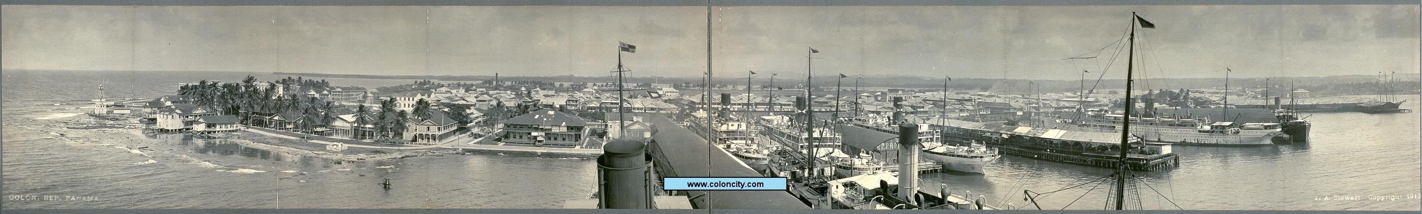
- Provisionally delimited the border between the Canal Zone and Colón (excluding La Terre Plein) and Colón harbor. The Canal Zone includes 30 meters around lighthouse in northwest Colón (see 1913 photograph of Colón waterfront), La Terre Plein and a 660-meter wide channel through Colón Harbor.
- 1904-12-12 (effective date of Taft Agreement of 1904-12-03): The maritime waters lying westerly of a line drawn from a stake set on Punta Mala in Panama City through the middle island of the three islands known as Las Tres Hermanas (said line extending three marine miles from mean low-water mark on Punta Mala) are in the harbor of Ancon, within the Canal Zone.
- 1915-05-01 (date of delivery of possession under Boundary Convention of Sept. 2, 1914), see https://drive.google.com/file/d/0B9LDb9lFYjVPLTVrTUctQzNOVDg/view?usp=sharing:
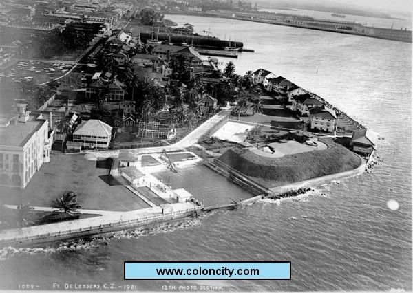
- Location of Battery Morgan in northwest Colón added to the Canal Zone, adjoining the lighthouse location (see 1921 photo)
- Altered the boundary in Colón harbor to bring new shipping terminals and water area into the Canal Zone
- The May 17, 1912, cession of Gatun Lake, its islands and limited access peninsulas made permanent and added to the Canal Zone
- Transferred the Sabanas area around Panama City from the Canal Zone to Panama (de-enclaved Panama City) and restored the western part of the Santa Cruz District from the Canal Zone to Panama City
- Moved the border with Panama City slightly eastward between Fourth of July St. and De Lesseps Park (matched the property line and apparently brought Bldg. No. 337 into the Canal Zone)
- Transferred a tract of land east of the Tivoli Hotel and north of De Lesseps Park from Panama City to the Canal Zone.
- The middle island of Las Tres Hermanas, lying on the maritime border in the harbor of Panama City, was made part of the Canal Zone. (1912 map showing islands' location: https://arquitran.files.wordpress.com/2015/05/screen-shot-2015-05-01-at-6-11-50-pm.jpg)
- 1919-09-18 (Letter from Canal Zone Governor to President of the Republic of Panama): all of Largo Remo (125 hectares) in Las Minas Bay added to Canal Zone (see http://images.library.wisc.edu/FRUS/EFacs/1920v03/reference/frus.frus1920v03.i0010.pdf).
- 1920-06-16 (effective date of Panamanian Executive Power Decree No. 15, dated 1920-06-12): 15 hectares on the Island of Taboga added to Canal Zone (see http://images.library.wisc.edu/FRUS/EFacs/1920v03/reference/frus.frus1920v03.i0010.pdf). "In 1920, the United States, under its right of expropriation in Article 2 of the canal treaty, required from Panama for the erection of defensive fortifications fifteen hectares of the island of Taboga in Panama Bay and a tract of one hundred and twenty-five hectares called Largo Remo in Las Minas Bay, east of Colón." (U.S. For. Rel., 1920, III, 314-322; 1921, II, 616-622)
- 1920-09-01 (Executive Order 3322): Punta Paitilla peninsula added to Canal Zone
- 1924-06-05 (Executive Order 4019): future Madden Lake area and downstream river and confluences of tributaries added to Canal Zone (See 35 CFR Section 1.4 and this map (https://catalog.archives.gov/id/6861831?q=map%2520panama%2520canal) dated January 1927, with additional hand-drawn markings dated 1932)
- 1939-07-27 (March 2, 1936 General Treaty of Friendship and Cooperation):
- By specifying metes and bounds, transferred a corridor consisting of the road from the Canal Zone boundary to Madden Dam into the Canal Zone
- Established Panamanian corridors of sovereignty along the road from the city of Colón to the Canal Zone-Panama border near Cativa, Panama. Reserved the rectangular area of its intersection with Randolph Road as an area of joint US-Panama sovereignty.
- Created a three-dimensional tube of Panamanian sovereignty to occupy the exact volume of a future overcrossing within the Colón corridor spanning the Canal Zone's Randolph Road
- 1955-04-11 (1950 Colón Convention):
- Significantly changed the route of the Panamanian corridor from Colón to Cativa:
- "between the boundary near Cativa and the Randolph Road overpass, the Colón Corridor will be altered to conform to that shown on Exhibit C of the Public Roads Administration (August 6, 1946, P.C. Drwg. No. V.F. 933-7C)."
- "between the Randolph Road overpass and the boundary line between the City of Colón and the Canal Zone, the corridor location will be altered to conform to that shown on Exhibit B of the Public Roads Administration (August 6, 1946, P.C. Drwg. No. V.F. 933-7B).
- Transferred some tracts of land either into the Canal Zone from Colón or into Colón from the Canal Zone, as specified in
- Exhibit A of the Public Roads Administration (August 6, 1946, P.C. Drwg. No. V.F. 933-7A), and
- Exhibit A of The Panama Canal (July 6, 1945, Panama Canal Drawing No. X-6113-53).
- Established Panamanian corridors on the Boyd-Roosevelt Highway as follows (see maps starting at numbered page 157 (the 173rd page of the pdf file) in the United Nations Treaty Book at https://drive.google.com/file/d/0B9LDb9lFYjVPZFVWV1VpV2gzYms/edit?usp=docslist_api ) :
- two corridor sections between the Canal Zone boundaries along the Quebrada Madronal and the Quebrada Moja Polla, along with a crossing that lies between them over the Rio Chagres (in the Canal Zone) within a three-dimensional tube of sovereign Panamanian jurisdiction.
- corridor at the Quebrada Madronal channel change
- crossing over the Gatun River (in the Canal Zone) within a three-dimensional tube of sovereign jurisdiction.
- crossing over Rio Chilibre (in the Canal Zone) within a three-dimensional tube of sovereign jurisdiction.
- crossing over Madden Road (an American corridor) within a three-dimensional tube of sovereign jurisdiction.
- 1955-08-23 (Remon-Eisenhower Treaty):
- U.S. ceded Punta Paitilla to Panama
- U.S. portion of the Island of Taboga ceded to Panama.
- U.S. ceded the De Lesseps area (old lighthouse location, Battery Morgan, residential buildings, but excluding two lots) to Panama
- Also in Colón, U.S. ceded the Playa de Colón, Nuevo Cristobal, lands on the westerly shore, railroad passenger station and site, and one lot to Panama.
- U.S. ceded two tracts in Panama City to Panama.
- Regarding the preceding four bullets, were these already under the jurisdiction of Panama? I.e., what does "certain lands situated in territory" mean? Sovereign enclaves within surrounding territory?
- Article V of the Boundary Convention signed in 1914, regarding the boundary between the City of Colón and the Canal Zone (as amended by Article I of the Colon Convention signed in 1950), was replaced in its entirety by verbiage (metes and bounds) describing the contents of the December 23, 1954, Panama Canal Company Drawing No. 6117-22, attached to the treaty.
- 1979-10-01: First cessions of land under the Carter-Torrijos Treaties
- 1999-12-31: Final cessions of land under the Carter-Torrijos Treaties
Jeff in CA (talk) 17:53, 28 June 2016 (UTC)
- You have the same ref for 1919 and 1920, but the ref only appears to be relevant for 1920. I looked through the Panama records for the 1919 volume but didn't find a relevant entry. --Golbez (talk) 03:30, 1 July 2016 (UTC)
- re 1920: This states that Punta Paitilla was "formerly situated within the Republic of Panama, but acquired by the United States Government and now a part of the Canal Zone" so it sounds like it's establishing a military reservation on land already part of Canal Zone, so it doesn't seem like this warrants mention. --Golbez (talk) 17:12, 1 July 2016 (UTC)
- re 1939: I'm trying to figure out the path here but it doesn't seem different from what's defined in 1955? Or, if it's different, it's probably not different enough to really show on the map. Do you maybe have a map of the 1939 orientation? Do you think I should move the corridor from 1955 to 1939, and for 1955 simply say it was redefined? (since the corridor, in some form, does appear in the map, but the changes may not be noticable) --Golbez (talk) 17:48, 1 July 2016 (UTC)
- re 1920: Well, the status of the entire Punta Paitilla peninsula after May 1, 1915, was that Panama owned all of it. Up until that date, over 99% of the peninsula was in the Canal Zone. Only the tiny tip of the peninsula was within Panama City from 1904-1915. So at a later date the U.S. reacquired the entire peninsula, going from owning zero to owning it all, sometime between May 2, 1915, and 1920. A map in an issue of the Canal Zone Record in early 1915, in a report on the new treaty, shows none of Punta Paitilla remaining in the Canal Zone.
- re 1939: I would have the creation of the Colon corridor in 1939, with redefinition in 1955. I will take a stab at inputting the given metes and bounds into on online tool and attempt to compare the two versions. I'll also look at a map that I found for one of those instances. Jeff in CA (talk) 01:32, 2 July 2016 (UTC)
- re 1939: A 1948 State Dept.memorandum on relations between the United States and Panama states, "Readjustment of Colon Corridor. Panama has requested a substantial readjustment in the route of a road which passes through the Canal Zone and joins the Panamanian city of Colon with the Republic proper. The realignment as contemplated deviates considerably from the Corridor plan as set forth in the 1936 Treaty. A new convention between the two Governments will be necessary to modify legally the 1936 Treaty. In the meantime, the two Governments have effected an exchange of notes which state that the readjustment is desirable from the standpoint of both Governments and provides that work on the realignment of the Corridor may be undertaken pending the negotiation of a convention." That convention was the Colon Convention signed in 1950. I compared maps of the Colon area from 1950 (Maps 2 and 3 in the UNTS book, linked above) and 1943. It is obvious that after 1943 the bay that is now called the Folks River was substantially filled in. This was just south of Colon, just east of its "neck." The 1936 treaty description routes the corridor around this water, going south from Colon parallel to Bolivar Hwy., then turning east at Silver City (now Rainbow City) to the Randolph Rd. intersection (i.e., somewhat L-shaped). The 1950 route has the corridor starting at the same starting point in Colon and running southeasterly directly over a filled-in part of the Folks River and on to the Randolph intersection. Without the benefit of seeing the 1936 Treaty's Exhibit A map, to my eyes, this is the only obvious or noticeable difference between the 1936 route and the 1950 route. Jeff in CA (talk) 20:28, 2 July 2016 (UTC)
- re 1920: According to Canal Governor's Annual Report for Year Ending June 30, 1919, p 94, Punta Paitilla was surveyed and mapped in the second half of 1918. Based on the result, the Governor of the Canal Zone expropriated, via a letter to the Panama Secretary of Foreign Relations in the second half of 1918, 50.6 hectares on Punta Paitilla (Panama Canal Record (Volume 13 (1919-20)), p 584-585). A claim judgment against the US for $101,200 for land title was entered in June 1920. Executive Order 3322 on Sept. 1, 1920, assigned the land for use as a military reservation.
- Also regarding Punta Paitilla, per a Congressional act approved May 3, 1932, the US gave back a small portion of land at the border between Panama and the US-held Punta Paitilla, in order that the US could build its embassy there on foreign soil. Jeff in CA (talk) 10:43, 7 July 2016 (UTC)
I found this Panamanian source today that contains some further information on land expriopriated by the U.S. for the Canal Zone.
http://www.panamaamerica.com.pa/content/ocupaci%C3%B3n-extranjera-del-territorio-nacional
Ocupación extranjera del territorio nacional
11/9/2004
© Panamá América S.A. - Ciudad de Panamá - Panamá
- April 28, 1904: the US Congress divides the Canal Zone territory into five municipalities: Ancon, Emperador, Gorgon, Buenavista and Cristóbal.
- June 15, 1904: The Boundary Convention was signed with provisional boundaries. Panama City and Colón were surrounded by the territory of the Canal Zone. A definitive demarcation of the border could not occur until 1906, as the type of channel and its central axis (from which the five miles on each side were to be measured) were not known until then.
- June 8, 1908: For the purpose of extracting stone for the Gatun Locks, the Zonian authorities took the grounds of a quarry in the city of Portobelo, near the San Fernando Castle, dozens of kilometers east of the border between the Canal Zone and the Republic of Panama (approx. 30 km by air), in the area of Colón-Las Minas Bay. It is the first time the Canal Zone is extended outside its provisionally delimited territory.
- May 17, 1912: The Canal Zone expanded by 167 square miles into territory under the jurisdiction of Panama. This was the land under Gatun Lake, including its banks to the altitude of 100 feet and its islands and peninsulas with restricted access.
- Later (1915): The US authorities occupy other areas near the mouth of the Chagres River in the Caribbean (near Fortress of San Lorenzo)
- September 2, 1914: The United States transferred to Panama the land of Las Sabanas to the east of the capital, abutting the sea in the areas of Punta Paitilla and San Francisco-Coco del Mar, in exchange for some land in the port of Colón. Panama City, completely enclaved at first, was freed from this situation.
- December 8, 1915: US authorities expropriated land on the Atlantic side of the isthmus, including:
- the triangle between the mouth of the Chagres River, the Caribbean Sea and the Canal Zone, where victims of the 1915 Cristóbal fire lived, and
- the historic Fortress of San Lorenzo.
- 1918: The Canal Zone was extended to incorporate 3,168 acres between the Chagres River and the Majagual River.
- September 18, 1919: The Governor of the Canal Zone informed the Government of Panama that he had taken "a small portion of land comprising the islands of Largo Remo, Drogue and two islets of unknown name, in Las Minas Bay ... " totaling 200 hectares.
- June 9, 1920: The governor of the Canal Zone announced the need for 14.95 hectares of the island Taboga. The Panamanian government decided provisionally to grant the area requested. The US eventually ended up with 33 hectares in five small plots in Taboga and Taboguilla.
- September 1, 1920: By Executive Order, 50 hectares in Punta Paitilla were added to the Canal Zone for a military reservation, on land that had reverted to the Republic of Panama just six years earlier.
- October 18, 1923: The US authorities take 22 square miles at the Chagres River.
- February 1, 1924: The Canal Zone incorporated the area that would contain Lake Alajuela as determined by research conducted a year earlier. [2016-07-21 side note: According to the 1924 Annual Report of the Panama Canal Governor (https://ia601406.us.archive.org/3/items/annualreportofgo1924cana/annualreportofgo1924cana.pdf , original page 13) the basin for Madden Lake "was transferred from Panama to the United States as provided in Article II of the HayBunau-Varilla treaty and incorporated with the Canal Zone, effective February 1, 1924."]
- December 3, 1924: The US authorities assumed jurisdiction over land to be assigned for Madden Dam (work commenced February, 1932, and ended February 9, 1935) and over the 50.2 square kilometers of Lake Alajuela.
- June 25, 1930: The Canal Zone was extended to include the island of Jicarote (Jicarita?) and 60 hectares of Punta Morro de Puercos, within Azuero, hundreds of kilometers from the canal, to install lighthouses.
- Under the Treaty of 1936:
- the United States was granted a corridor of land to connect the Canal Zone with the Madden Dam by a 22-mile concrete road (begun in 1929 and completed in 1930).
- the city of Colón, which had been enclaved by Canal Zone territory, was joined by a corridor under Panamanian jurisdiction to the main territory of Panama.
It is evident that the uncited source for the Panamanian article is The United States and the Republic of Panama, by William D. McCain, originally published in 1937. It has a wealth of citations to primary sources; its second printing is available at http://dli.ernet.in/handle/2015/509283. Chapter 7, "Territorial Expropriation," contains most of this information. The author of the Panamanian article made a few mistakes, as did an author of a 2003 book that cites McCain's work. From my own study of McCain's material, I recommend that the following items be added to the Table of Changes in this Wikipedia article:
| Date | Event | Map | Change |
|---|---|---|---|
| May 27, 1915 | Under Article II of the 1903 Treaty, the U.S. expropriated from Panama several areas around the mouth of the Rio Chagres, adding them to the Panama Canal Zone.[5] | too small to map | |
| December 8, 1915 | The U.S. expropriated from Panama a triangle of land, which included the historic Fort San Lorenzo, between the Rio Chagres, Caribbean Sea and the Panama Canal Zone, to which it was added.[5] | too small to map | |
| July 12, 1918 | The U.S. expropriated from Panama 2.6 hectares of land at Punta Paitilla in Panama City and added it to the Panama Canal Zone.[6] That area was enlarged to about 50 hectares several months later.[5][7][8] | too small to map | |
| August 21, 1918 | The U.S. expropriated from Panama 1282 hectares of land between the Rio Chagres and the Quebrada Majagual and added it to the Panama Canal Zone.[5][8] | too small to map | |
| July 18, 1927 | The U.S. expropriated from Panama another 33 hectares of land on the islands of Taboga and Taboguilla and added it to the Panama Canal Zone.[5] | too small to map | |
| September 24, 1928 | The U.S. expropriated from Panama three hectares of land at El Cerro de Doscientos Pies ("200-Foot Hill") near Las Minas Bay and added it to the Panama Canal Zone.[5][8] | too small to map | |
| July 22, 1930 | The U.S. expropriated from Panama 25 hectares on Jicarita Island and 60 hectares at Punta Morro de Puercos and added them to the Panama Canal Zone.[5] | too small to map | |
| April 15, 1931 | The U.S. expropriated from Panama additional areas around the soon-to-be-built Madden Dam and added them to the Panama Canal Zone.[5][8] | too small to map | |
| May 3, 1932 | The U.S. adjusted the border at Punta Paitilla in the Canal Zone, returning a small amount of land to Panama. This was the site for a planned new U.S. embassy, which had to be built on foreign soil.[9] | too small to map | |
| July 27, 1939 | Panama gained a corridor that was carved out of the Panama Canal Zone connecting Colón with the rest of Panama, along with a three-dimensional "tube" of sovereignty for a future crossing over a U.S. highway. A corridor consisting of the road from the Canal Zone boundary to Madden Dam was transferred into the Canal Zone. | too small to map | |
Jeff in CA (talk) 15:44, 10 July 2016 (UTC)
- ^ Wright, J. Leitch (1972). "Research Opportunities in the Spanish Borderlands: West Florida, 1781-1821". Latin American Research Review. 7 (2). Latin American Studies Association: 24–34. Wright also notes, "It was some time after 1785 before it was clearly established that Suwannee was the new eastern boundary of the province of Apalachee."
- ^ Weber, David J. (1992). The Spanish Frontier in North America. New Haven, Connecticut, USA: Yale University Press. p. 275.
Spain never drew a clear line to separate the two Floridas, but West Florida extended easterly to include Apalachee Bay, which Spain shifted from the jurisdiction of St. Augustine to more accessible Pensacola.
- ^ "The Evolution of a State, Map of Florida Counties - 1820". 10th Circuit Court of Florida. Retrieved 2016-01-26.
Under Spanish rule, Florida was divided by the natural separation of the Suwannee River into West Florida and East Florida.
- ^ Klein, Hank. "History Mystery: Was Destin Once in Walton County?". The Destin Log. Retrieved 2016-01-26.
On July 21, 1821 all of what had been West Florida was named Escambia County, after the Escambia River. It stretched from the Perdido River to the Suwanee River with its county seat at Pensacola.
- ^ a b c d e f g h McCain, William D. (1965). The United States and the Republic of Panama (2nd printing). New York: Russell & Russell. p. 144-159.
- ^ "Letter, Chester Harding (Governor of the Panama Canal Zone) to Luis Urriola (President of the Republic of Panama), July 12, 1918". Memoria que presenta el Secretario de Relaciones Exteriores a la Honorable Asamblea Nacional en sus Sesiones Ordinarias de 1918. Panama: Republic of Panama: 303–305. 1919.
- ^ "The Panama Canal Record". Vol. XIII, no. 39. Balboa Heights, Canal Zone: The Panama Canal. May 12, 1920. p. 584-585.
... it was not until the year 1918, when the Governor of the Canal Zone addressed a communication to the to the Secretary of Foreign Affairs of the Republic of Panama stating that the United States Government would require 50.6 hectares, that the exact area expropriated was definitely known.
- ^ a b c d Panama Canal Zone and Vicinity Showing Judicial Districts (Map). National Archives, College Park, Maryland: United States Army. 1927. (with hand-drawn features dated 1932)
- ^ 47 Stat. 145
British West Florida
In the description dated May 12, 1784, it's stated that Great Britain had moved West Florida's border south. This they did not do. In 1764 Britain had moved the boundary north to 32° 22′. In the separate treaties with Britain at the end of the Revolution, the U.S. got Britain's land east of the Mississippi, while Spain got British West Florida. Both Spain and the U.S. believed they owned the land between 31° and 32° 22′. The dispute was finally resolved with Pinckney's Treaty in 1795, in which both parties agreed on the 31st parallel. But up until 1784, the land below 32° 22′ was without a doubt part of the British West Florida colony. Both of Britain's Florida colonies, West Florida and East Florida, remained loyal to Great Britain during the American Revolution (refusing invitations from the other colonies to join them), unlike their neighboring colony of Georgia. The outline maps prior to 1784 should be adjusted, IMHO, to exclude the area of British West Florida. Jeff in CA (talk) 14:31, 4 July 2016 (UTC)
- I've changed the wording of 1784-05-12 to properly say that GB had moved the border north, but in ceding it back slyly gave back the original extent.
- As for excluding British West Florida, hm. This goes back to a question I had a few days ago and asked on WP:RDH but not here: What are the borders of the United States prior to the Treaty of Paris? Or, put another way, what borders did the United States claim? I've seen anywhere from just the Proclamation Line, to all the way to the Mississippi, and there's evidence for both. Do you have any ideas on that? Though in the meantime, you seem to be saying that either way, Georgia should omit West Florida, and I can go with that, having no other evidence that Georgia considered itself as including West Florida... [am I making sense?] --Golbez (talk) 20:06, 4 July 2016 (UTC)
- Yes, you do make sense. I hadn't thought about it much, but I would think that individual states prior to that treaty would each have their own claim and a rationale for it. I suspect that some still claimed what was specified in their original royal charters (such as "sea to sea") to whatever maximum extent that meant, even when in conflict with other states' claims. I would think that Great Britain would at least have paid lip service to those charters from the previous century. However, I know very little of British plans and policy regarding their newly-acquired chunk of French Louisiana following 1763, other than carving most of British West Florida out of it. Britain's acquisition of these western lands from France would have been a likely time for any prior colonial claims to be resurrected, if indeed any were. American settlers had not yet streamed west of the Appalachians in great numbers, so my guess is that prior to the Revolution the British military exercised control over the sparsely populated region, and the colonies had little they could say about it. During the war I doubt there was much incentive for the states to revise their claims or make new claims while trying to defend their established population centers, as victory in the independence struggle was far from certain. And yes, I am saying that either way, Georgia should omit West Florida. I'd also be interested to see if you get any further response from the Reference Desk. Jeff in CA (talk) 09:51, 5 July 2016 (UTC)
- Eh, didn't get much. OK, I'll trim West Florida from Georgia, and maybe include the Proclamation Line in the first frame, but I know that some states claimed areas beyond it as counties before the Treaty of Paris, so it wasn't a hard limit. --Golbez (talk) 10:00, 5 July 2016 (UTC)
- re charters, I think many of the original charters were given as proprietary grants. Over time, I think most, if not all, of the colonies become royal colonies which may or may not have made the original charters mostly irrelevant (at least from the royal perspective--though when it came to the post-revolution land grab, several states were keen on reviving the sea-to-sea terms). older ≠ wiser 11:20, 5 July 2016 (UTC)
- Just now reading up on this. What about the modifications made to the Proclamation Line in 1768 and 1770 by treaties with the Iroquois and Cherokee Nations (Treaty of Fort Stanwix, Treaty of Lochaber)? Jeff in CA (talk) 20:01, 5 July 2016 (UTC)
- Also, I see the new wording in the May 12, 1784 entry. I think it's not totally accurate on this. In the separate treaties with Britain at the end of the Revolution, the U.S. got Britain's land east of the Mississippi, while Spain got British West Florida. IIRC, the dispute between Spain and the US was created because the northern boundary of West Florida was not specified at all in either treaty. I don't think that Britain "in ceding it to Spain only included the original borders." Jeff in CA (talk) 03:34, 11 July 2016 (UTC)
- Just now reading up on this. What about the modifications made to the Proclamation Line in 1768 and 1770 by treaties with the Iroquois and Cherokee Nations (Treaty of Fort Stanwix, Treaty of Lochaber)? Jeff in CA (talk) 20:01, 5 July 2016 (UTC)
- re charters, I think many of the original charters were given as proprietary grants. Over time, I think most, if not all, of the colonies become royal colonies which may or may not have made the original charters mostly irrelevant (at least from the royal perspective--though when it came to the post-revolution land grab, several states were keen on reviving the sea-to-sea terms). older ≠ wiser 11:20, 5 July 2016 (UTC)
- Eh, didn't get much. OK, I'll trim West Florida from Georgia, and maybe include the Proclamation Line in the first frame, but I know that some states claimed areas beyond it as counties before the Treaty of Paris, so it wasn't a hard limit. --Golbez (talk) 10:00, 5 July 2016 (UTC)
- Yes, you do make sense. I hadn't thought about it much, but I would think that individual states prior to that treaty would each have their own claim and a rationale for it. I suspect that some still claimed what was specified in their original royal charters (such as "sea to sea") to whatever maximum extent that meant, even when in conflict with other states' claims. I would think that Great Britain would at least have paid lip service to those charters from the previous century. However, I know very little of British plans and policy regarding their newly-acquired chunk of French Louisiana following 1763, other than carving most of British West Florida out of it. Britain's acquisition of these western lands from France would have been a likely time for any prior colonial claims to be resurrected, if indeed any were. American settlers had not yet streamed west of the Appalachians in great numbers, so my guess is that prior to the Revolution the British military exercised control over the sparsely populated region, and the colonies had little they could say about it. During the war I doubt there was much incentive for the states to revise their claims or make new claims while trying to defend their established population centers, as victory in the independence struggle was far from certain. And yes, I am saying that either way, Georgia should omit West Florida. I'd also be interested to see if you get any further response from the Reference Desk. Jeff in CA (talk) 09:51, 5 July 2016 (UTC)