
Talk:Rockall/Archive 1
| This is an archive of past discussions. Do not edit the contents of this page. If you wish to start a new discussion or revive an old one, please do so on the current talk page. |
| Archive 1 | Archive 2 | Archive 3 | Archive 4 |
Additional Picture
I'd love to include this picture [1] and the story behind it in this article but I'm just not 100% sure that it's genuine. Mintguy (T) 12:14, 18 Feb 2004 (UTC)
![[1]](http://www.therockalltimes.co.uk/rockall/guards.jpg)
Image with UK in brackets
... copied from User_talk:Metron
Why did you remove UK from the map of Rockall? Although it is claimed by some other nations. The United Kingdom is in active possesion. Mintguy (T) 12:40, 5 Oct 2004 (UTC).
The possesion of Rockall is quite disputed. Your postion is not widely accepted. Therefore I removed UK from the map. Metron 15:40, 5 Oct 2004 (UTC)
- I know that the isle is in dispute. I wrote a lot of that article. The realpolitik though is that the islands are in the possesion of the United Kingdom, by act of Paliament no-less. AFAIK No other state has officially incorporated the isle into thier nation. That other states claim the islands is irrelevent. If France decided to claim the Isle of Wight, but did nothing to take possesion, would you suggest that we removed any mention of UK from the map the Isle. Would you suggest that we should do the same for the Falklands Islands? Mintguy (T) 22:09, 5 Oct 2004 (UTC)
- Did not the Irish band the Wolfetones do a stunt some time in the early 90s to try to further Ireland's claims to Rockall? I think it is reasonable to say that only the UK has actively pursued its claim to sovereignty. Dbiv 00:21, 26 Oct 2004 (UTC)
- quote: {The United Kingdom continues to claim jurisdiction over Rockall, but this claim is not accepted by Ireland. Each country remains aware of the continuing position of the other.} see [2] --ClemMcGann 23:10, 21 Apr 2005 (UTC)
User:Jooler wrote to me
- The text "the designation (U.K.) is in dispute." is not stating that the ownership of the island is dispute but that the use of UK on the "caption" is in dispute. The island is actually part of the UK by Act of Parliament and no other country has officially incorporated the island into their nation. Just like the Isle of Wight or Gibraltar the place is de facto and de jure administered from the United Kingdom. Yes several nations claim the isle as thier own, but only one nation has it in law. Just like Jersey and Guernsey on the same map, Rockall is part of the UK at the moment. Whether France or Ireland or the man on the moon choose to not recognise that the Isle of Wight is part is of the UK is irrelevant to its status and the same is true of Rockall. No other nation is in active possession or has taken any steps to lay claim either through legal means or by threat of occupation. Argentina claims the Falkland Islands but UK appears on the map. The designation of UK on the isle for the map is correct. Jooler 12:00, 22 Apr 2005 (UTC)
I replied
- Yes, the use of UK on the caption is in dispute. The UK Parliament could make an Act claiming that Alpha Centauri is part of the UK, but that wouldn't make it so. No other nation has incorporated it because rocks have no status. The place is not de facto part of the UK because it is uninhabitable (unlike island off the coast of Scotland that have been abandoned, and no Act of the UK Parliament (to feed the British tabloids) is capable of overturning international law. --Red King 17:10, 22 Apr 2005 (UTC)
Is it time to declare a disputed page?
Debate continues at Reverting dispute below
the Law of the Sea
The United Nations convention on the Law of the Sea, which was adopted at Montego Bay, on 10 December 1982. http://www.un.org/Depts/los/convention_agreements/texts/unclos/part8.htm states "Rocks which cannot sustain human habitation or economic life of their own shall have no exclusive economic zone or continental shelf." The United Kingdom acceded to the convention on 25 July 1997. Therefore all this suggestion that the rock carries an 200 mile economic zone are meaningless.
Rockall is 265 miles from Donegal, 298 miles from the Scottish mainland, 450 miles from Iceland and 400 miles from the Faroe Islands
There is a ledged that a Celtic monk lived on the island, living on fish and birds. It seems that he was Irish, but reported to an Icelandic Abbott. A more reliable reference is in ‘Navigatio Sancti Brendani Abbatis’ circa 910AD, which describes the difficulties Brendan the Navigator had in landing on the rock, with its sheer cliffs and no refuge.
Back, in 1955, when the Blue Streak rocket was being tested, the UK authorities asked for, and were granted, Irish permission to test fire the rocket. This suggests that the British, prior to 1955, recognised Irish sovernity over Rockall.
- Firstly the Blue Streak Rocket wasn't first tested until 1958. Secondly all of the tests were conducted in Australia at the Woomera rocket testing facility. You presumably mean the testing of the Corporal missile which was the reason for the annexation in the first place. Any evidence for this claim? Jooler 12:23, 27 Apr 2005 (UTC)
How possible claims could be made:
- Ireland: it is nearest to mainland Ireland.
- United Kingdom: ‘island hopping’ is within 200 miles of Saint Kilda. Saint Kilda is now uninhabited. Saint Kilda is 100 miles west of Harris. Harris is one of the Outer Hebrides. ... ...
- Denmark: it is part of an underwater mountain chain which includes the Faeroes. if sea levels dropped sufficiently, it would join the Faeroes.
- Iceland: The Rockall Trough, which is more than 3,000 metres deep, lies between the British Isles and the Rockall plateau, invalidating any Irish or British claim.
Reverting dispute
Like countries argue about tiny irrelevant rocks in the middle of nowhere, Wikipedians argue about single sentence picture captions. The big deal here is whether the caption of the map should say "The designation (U.K.) is disputed" or "Ownership is disputed". I don't see why it matters but Jooler contends that a dispute about these brackets is something separate from dispute about ownership. Users ClemMcGann, Red King and myself have all reverted Jooler's edits on this. This issue does not need to get out of hand and we should be able to resolve it without flagging the page as disputed or protecting it. I invite all the involved editors to please try and reach an agreement on this rather minor point and ask of them all to refrain from editing the caption until some sort of a agreement is reached. I would also like other Wikipedians to have their say on the issue.
My personal proposal in the matter is to drop the disputed line altogether, bring back the map without the brackets (see here) and just let the article itself explain the status of the rock. --Bjarki 18:08, 22 Apr 2005 (UTC)
- I think the unbracketed map is a good solution. Let the article explain the dispute. Jonathunder 19:20, 2005 Apr 22 (UTC)
- I'm prepared to accept that arbitration. However, to avoid disputable inferences being drawn, it would be politic to remove the designation "(Den)" from the Faroes for consistency. (Indeed I suspect that there may be some dispute about that too, given the constitutional status of the Faroes.) --Red King 19:37, 22 Apr 2005 (UTC)
- unbracketed map is a good idea. The dispute is not about ownership per se, but whether anyone can own a rock in international waters --ClemMcGann 20:01, 22 Apr 2005 (UTC)
- Let's get this straight. I have no issue about the disputed status of the Isle. I couldn't give a hoot. This argument is nothing to do with the disputed status of the isle. It is merely about a form of words. Not long ago an anon editor added the words "The designation (U.K.) is disputed" - what does this mean? Does it mean ownership of the island is in dispute or does it mean that the (U.K) part of the caption on the map is disputed. I.e. Is someone disputing the status of the island or are they disputing the neutrality of the page? To me it was unclear, and so I removed it. User:ClemMcGann kept re-adding it, and then Beirko stepped in and re-added it again. So I decided to rephrase the line to "Ownership is disputed". Which was not dissimilar to a form of words suggested by User:Biekko. Now another user Red King has stepped in and reverted the page again to the strange form of words "The designation (U.K.) is disputed". The U.K. tag on Rockall on this map serves exactly the same purpose as the U.K. on the islands of Jersey and Guernsey on the same map. It indicates who has legal title to the isle. Yes other nations claim it. Spain claims Gibraltar and Argentina claims the Falkland islands. The are several islands disputed between Japan China and South Korea. In all of these circumstances and others the labels attached to the maps indicate the nation that is the de facto and de jure governing authority. Why should Rockall be any different? In this instance the authority that has control of Rockall is the United Kingdom. That is a point of fact. Other nations claim the isle but no other nations has taken it upon themselves to act on that claim in anyway whatsoever. Rockall is part of the UK by Act of Parliament. If Holland made a claim on the Isle of Sheppey should we remove the UK designation? The disputed status of the ilse is discussed fully in the article. Whatever the right and wrongs of it the UK holds title to the isle. It is correct to have UK on the map until such time as some other country takes over. Jooler 22:06, 22 Apr 2005 (UTC)
I am disappointed in the biased behaviour of Jooler. Jooler thinks that <authority that has control of Rockall is the United Kingdom> The only authority there is – beleve it or not – Waveland. They were the last there and they will occupy the rock again from June 11 to June 24 2005.
Meanwhile the (Irish) Marine Institute continue to survey the seabed off Donegal, which includes the Rockall plateau, east of Rockall.
Back in 1972 the UK declared that no ship would be allowed within a 50-mile radius of the rock. If the UK had any < facto and de jure governing authority> this would be enforced. The reality is thet they don’t and no one respectes their claim.
There is no comparision between Rockall and the islands Jooler mentions. They have populations who can determine their own destiny. Rocks are uninhabitable. Rockall is outside the 200 mile limit. It is outside the remit of the UK. The phrase ‘ownership is disputed’ implies that it can be owned. Since the UK does not own the rock, either it should be removed from the map, or at a minimum, the words "The designation (U.K.) is disputed" should be left intact. The map itself is useful – from an Icelandic point of view – because it illustrates the Rockall Trough, which is more than 3,000 metres deep, lies between the British Isles and the Rockall plateau, invalidating (in Icelandic opinion) any Irish or British claim. Its curious the Jooler starts with <about the disputed status of the Isle. I couldn't give a hoot> anf finishes with biased opinion attempting to support the UK claim. I am disappointed with the behaviour of Jooler. Lets put back the unbracketed map - --ClemMcGann
- Eh? What biassed opinion? I express no opinion about the various claims on the island, merely that the island has been declared part of the UK and no-one else has made any effort to overturn that by legal means or force. If we show a map of Nazi Germany after the annexation of Austria we do not state that the claim on Austrai is disputed. Similarly we do not indicate anything about the status of Hawaii which was annexed by the United States. So why Rockall? Jooler 22:50, 22 Apr 2005 (UTC)
- Please try to understand. We are not discussing habitable land. It is a rock. It is 300 miles from Scotland. It is in international waters. There is no equivalence between it and Austria or Hawaii. Part of the original UK claim – and the UK Rockall Act – was legally reversed when the UK signed the Law of the Sea convention. Everyone ignores the UK claim. Green peace or Wave Land have occupied it in the past and will next June. The UK do not own it, they can’t own it. If it was habitable then perhaps they could own it. However it is nearer to Donegal than to Scotland. Please try to understand, ownership of a remote rock is more akin to ownership of an iceberg.--ClemMcGann 22:59, 22 Apr 2005 (UTC)
- I have made three attempts at compromise, yet you insist on using the clumsy phrasing "The designation (U.K.) is disputed" - I hope you can accept the latest version, because this is just getting too darned stupid to be true. Jooler 23:01, 22 Apr 2005 (UTC)
- And Gibraltar is nearer to Spain than Britain. WTF has that got to do with anything!? The Law of the Sea refers to the EEZ not to the territory of the rock. It has no bearing on this territory only to the seas around it. Greenpeace is not a state. Jooler 23:06, 22 Apr 2005 (UTC)
- You are reverting without due consideration. What is wrong with the words "The legality of the United Kingdom's claim to the island is disputed." ? Jooler 23:15, 22 Apr 2005 (UTC)
- because its not just the leagility of a claim, its the possibility of such a claim --ClemMcGann 23:34, 22 Apr 2005 (UTC)
- I'm sure I'm over the three revert limit. I have been trying to compromise and have used three different versions so whether that counts as revertign or not I don't know. - However ClemMcGann is being uncompromising and unreasonable and is definiately over the 3 revert limit. He is continually reverting to the same clumsy wording. Goodnight. Jooler 23:23, 22 Apr 2005 (UTC)
- Allowing that map with (UK) on it, even with the caption "The designation (U.K.) is disputed" may have been a mistake, we should have used this map [3] --ClemMcGann 23:34, 22 Apr 2005 (UTC)
I've reverted to Jooler's wording, which seems more accurate; it's not the designation that's disputed, but the claim, surely. On the other hand, ClemMcGann's alternative map would be better, I think. Re there any objections to using it? Mel Etitis (Μελ Ετητης) 08:31, 23 Apr 2005 (UTC)
- Yes I object to using the map without the UK caption, because it is wrong!. Rightly or wrongly the UK has title over Rockall. Look at List of disputed or occupied territories Rockall is correctley listed under the UK with the other nations claiming it in brackets. Jooler 08:54, 23 Apr 2005 (UTC)
- correction - neither the UK nor anyone else has title. Wiki is not the place for propaganda - lets revert to the unbracketed map
- --ClemMcGann has reverted to the stupid form of words for about the eighth time (this time after Mel Etitis's edit). I think you can now see who the belligerent one is. Jooler 09:04, 23 Apr 2005 (UTC)
- The words were not mine. The words are not stupid. Jooler changed the words to ones that are biased in that they imply the the UK could own a rock 300 miles from Scotland in international waters. --ClemMcGann 13:21, 23 Apr 2005 (UTC)
- This is getting very "meta-wiki"! The status of Rockall is disputed, and the statement that it is disputed is itself disputed! --Red King 09:44, 23 Apr 2005 (UTC)
- For the Nth time I have no dispute with stating that the UKs claim on the isle is disputed. Originally I removed the unweildy text "The designation (U.K.) is disputed" because of the clumsy use of words. After repeated reversions I rephrased it with what to my mind is a perfectly acceptable phrase, but ClemMcGann is being belligerent and insists on using the clumsy phrasing. Jooler 09:55, 23 Apr 2005 (UTC)
- The objection is not just putting (UK) on the map. The same objection would be if you put (DEN) or (IRL) or whatever on the map. A rock in international waters cannot be part of any national territory. There was nothing wrong with the text. You have no justification in replaceing it with misleading text. --ClemMcGann 13:21, 23 Apr 2005 (UTC)
Rockall is approximately 198.1 nautical miles from Aird An Runair, permanently inhabited island of North Uist (approximately WGS84 Latitude North 57 Degrees 36 Minutes 9.7 Seconds, Longitude West 7 Degrees 32 Minutes 56.4 Seconds). Have found a website which calculates the distance between two different points, to a millimetre. It confirms the accuracy of my GPS. http://www.movable-type.co.uk/scripts/LatLongVincenty.html ClemMcGann claims that ""island hopping", (international) legality of which is doubtful." Article 121 seems to condradict this. Please also see, "Just exactly how far from anywhere is it?" Sulasgeir 17:32, 21 May 2006 (UTC)
Another compromise proposal

Bjarki proposed a compromise that the map be purely a geographic map, with no political designations. That appeared to remove the cause of the dispute. But Jooler argues (I think) that showing it without a designation when other designations (such as Faroes "(Den)") are shown is not neutral, that it lends weight to the argument that it cannot be designated. So may I offer another compromise proposal: a purely topological map of the North Atlantic, with none of the land-masses designated. A satelite pic would be ideal, except that the expletive deleted thing is too small to show up from orbit! How about we emulate the map of Vanuatu as I've shown here? Though the sea bed has to be included! --Red King 09:44, 23 Apr 2005 (UTC)
- The CIA map which shows the continental shelf is too valuable to throw away. And the use of UK on the caption is legitimate inasmuch as the fact that the UK annexed the island in the 50s and made it part of the United Kingdom in the 70s and it currently maintains the navigational beacon located on the isle. Jooler 09:58, 23 Apr 2005 (UTC)
- At the risk of agreeing with Jooler, the 'cia' map does show the 10,000 feet deep trough, which is the basis of the Icelandic case, which will be addressed in 2006.
- The maintaince of navigational beacons are not relevant. For example the navigational beacons in Northern Ireland are maintained by the Irish-flagged MV Granuaille, operating out of Dun Laoghaire. (There is a complex system to finance this)--ClemMcGann 13:33, 23 Apr 2005 (UTC)
Ok, I have been away from the computer since I made my last proposal for a compromise and I find the volume of discussion amazingbut it does not seem to have helped in solving this mega-issue. I find Red King's proposal the most viable one. I am already working on erasing all political designations from the CIA map and it should be ready sometime today. I hope that all parties can agree on that. --Bjarki 12:01, 23 Apr 2005 (UTC)
- No. The isle was annexed by the UK in 1955 and made a part of Scotland in 1972. Jooler 12:24, 23 Apr 2005 (UTC)
- I fail to see how that is an objection to a strictly geographic map. --Bjarki 12:50, 23 Apr 2005 (UTC)
- Yes, Bjarki, thanks--ClemMcGann 13:33, 23 Apr 2005 (UTC)

Here is the map without any political features. --Bjarki 13:37, 23 Apr 2005 (UTC)
- That seems to me to be the only reasonable NPOV version. --Red King 13:49, 23 Apr 2005 (UTC)
It's difficult to see what anyone could have against that. Mel Etitis (Μελ Ετητης) 14:02, 23 Apr 2005 (UTC)
- Bjarki, I thank you. Now lets look forward to the Waveland occupation in June. :) --ClemMcGann 14:14, 23 Apr 2005 (UTC)
- What use is a map with no labels? For those who are geographically challenged it could be anywhere in the world. Jooler 14:39, 23 Apr 2005 (UTC)
- The scary thing is that I think you are being serious with the comment above...--Bjarki 14:51, 23 Apr 2005 (UTC)
- Er... it's on a page about Rockall. Who do you think is going to be reading this article — George W. Bush? Mel Etitis (Μελ Ετητης) 15:01, 23 Apr 2005 (UTC)
- What use is a map with no labels? For those who are geographically challenged it could be anywhere in the world. Jooler 14:39, 23 Apr 2005 (UTC)
- The point is that removing the labels from the map loses information. It serves only one purpose, to pander the viewpoint that the island can have no territorial claim by the United Kingdom. This is a POV. Removing the labels is actually an anti-NPOV move. Lets look at the facts. The UK annexed the island in 1955, and formally incorporated it into the UK in 1972. It is part of the UK. As such it is listed on the following Wikipedia pages - Inverness-shire, Geography of the United Kingdom extreme points of the United Kingdom, List of the British Isles, List of islands of Scotland etc. Ireland no longer make any claim on the Island. In any case the nearest point of land to Rockall is not in Ireland but is in fact Saint Kilda in the Western Isles of Scotland. It is within 200 miles of St Kilda and formerly the limit of 200 miles for territorial waters meant that Rockall was within the territorial waters of the UK. In 1997 the UK Government ratified the United Nations Convention on the Law of the Sea. This treaty has no bearing whatsoever on the status of the island of Rockall. It concerns itself with the sea-bed and fisheries. British territorial rights in this area are now derived from the St Kilda archipelago at 57 50N 8 40W, as Rockall is within 200 of St Kilda it includes Rockall itself. As a result Scots law still applies to the Rock under the Isle of Rockall Act 1972. No other nation lays claim to the rock anymore, they just ignore it. Jooler 15:16, 23 Apr 2005 (UTC)
- If Rockall was part of the UK, then the UK 200 mile limit would be drawn from Rockall - it is not. Therefore Rockall is not part of the UK. The Rockall Act claimed not only the rock but also the fish in the sea and the mineral rights to the seabed. The UK is *not* exercising these rights. --ClemMcGann 16:28, 23 Apr 2005 (UTC)
- This is not true. The UK ratified the Law of the Sea treaty reliquishing the right of an EEZ surrounding the isle, because the treaty specifically states that uninhabitable lands cannot be used to delineate the EEZ. This is not the same as reliquishing the claim on the land of Rockall itself, and indeed the UK still claims 12 miled territorial waters around the island. But even so, the island of Rockall lies within the 200 miles EEZ of the UK as measured from St Kilda and given this, it gives the UK exclusive rights to use the resources within this zone (including the land of Rockall) as they see fit. Jooler 20:15, 23 Apr 2005 (UTC)
What information has been lost from the article? Mel Etitis (Μελ Ετητης) 15:42, 23 Apr 2005 (UTC)
- The graphical illustration of the fact that the UK has a de jure and de facto claim on the island and that no other nations has a similar entitlement. If you do not live in the UK and you have an atlas not published in the UK, please look in it and see what label is attached to Rockall? Jooler 15:48, 23 Apr 2005 (UTC)
- In other words, no information has been lost — only the graphical presentation of information that's there in the text. I find it very difficult to get worked up over that, and it certainly doesn't breach NPoV policy. Mel Etitis (Μελ Ετητης) 15:56, 23 Apr 2005 (UTC)
- I say it does. There was nothing wrong with the map that was there previously. It has been there for quite some time. The map has now been changed to satisfy the opinion of someone who does not accept the British claim despite the fact that under internatinal law the isle falls within the 200 miles limit of the UK. Under the Law of the Sea - "The EEZ extends the sovereignty of the coastal state in relation to the exploitation, conservation and management of natural and living resources fishery and mineral resources to 200 miles" - Rockall is less than 200 miles from St Kilda. Rockall lies within the UK's EEZ. Ireland and the UK have signed a boundary agreement regarding their respective EEZs and as part of the agreement Ireland has accepted that Rockall lies within the UKs EEZ. Jooler 16:03, 23 Apr 2005 (UTC)
- By signing the Law of the Sea, the UK was contradicting some of the provisions of the Rockall Act. It would seem that this so-called law was merely a negotiating ploy. It was ignored. It failed. --ClemMcGann 16:28, 23 Apr 2005 (UTC)
- Ireland has accepted that the UK can claim a 200 mile eez from St Kilda, provided that there is no eez from rockall. Ireland and the UK agreed to this. (even though it renders provisions of the Rockall Act void). But Denmark and Iceland have not. They want the Irish and UK eez to stop at the Rockall Trough. There is a conference next year in Galway to discuss this issue. --ClemMcGann 16:28, 23 Apr 2005 (UTC)
The point is that, whatever Jooler asserts, the use of the new map doesn't affect the article, doesn't make the article PoV, and so is perfectly in keeping with Wikipedia policy. He's worked up because of the reason for the change, but what matters is what's in the article — what the reader sees. Mel Etitis (Μελ Ετητης) 16:42, 23 Apr 2005 (UTC)
- Please don't try to read my mind, you might get a headache. I claim that removing labels on a perfectly legitimate map to satisfy the belligerence of a user who diputes the UK's claim to the isle -- despite the physical annexation of the isle; despite the proximity of the Isle to territory of the United Kingdom; depsite international law declaring that the isle is within the UK's EEZ; despite legislation passed within the UK to re-affirm that claim; despite the physical occupation of the isle and despite a boundary agreement signed between the UK and Ireland -- is pandering to a POV. As it stands at the moment, and as I have pointed out innumerable times, Rockall IS part of the UK, de jure and de facto. So why remove the labels? Would you remove the labels from any other part of the UK because someone somewhere disputes it? Jooler 16:48, 23 Apr 2005 (UTC)
- <depsite international law declaring that the isle is within the UK's EEZ> I don’t like saying this, but it is not international law, it was an agreement between Ireland and the UK. It is not accepted by Denmark or by Iceland. --ClemMcGann 17:06, 23 Apr 2005 (UTC)
- Denmark and Iceland are neither here nor their with regard to Rockall and the EEZ as their EEZ wouldn't extend that far. The UN treaty regards Rockall was within the UK's EEZ. The boundary between the UK and Ireland's EEZ was a separate agreement. Jooler 17:14, 23 Apr 2005 (UTC)
- I'm been made out the villain here. But what about ClemMcGann who reverted this page something like 12 times back to saying "the designation (U.K.) is in dispute." Jooler 16:52, 23 Apr 2005 (UTC)
- It was ok - you should not have changed it --ClemMcGann 17:01, 23 Apr 2005 (UTC)
- I changed it because it didn't make any sense. What did it mean? I changed it and several other people changed it and you kept changing it back. Jooler 17:14, 23 Apr 2005 (UTC)
- I note that Jooler is now abbreviating the “Irish claims to Rockall“ paragraph in the article. It used to point out that Rockall is 424 km from Donegal while it is 480km from Scotland. Those facts should have been left together. They are only relevant when placed side by side. He has moved the “480km from Scotland” phrase to the UK claim paragraph. Why have it there? It hardly supports the claim. Is the object to obscure the fact that Rockall is nearer to Donegal? Any equivalent UK claim would then have to be based on “island hopping”, the (international) legality of which is doubtful. --ClemMcGann 17:01, 23 Apr 2005 (UTC)
It's actually nearest to Saint Kilda. To be precise the EEZ extends 200 miles from the territorial waters of a state, where the territorial waters are 12 miles from habitable territory of the state.In this the EEZ extends from St Kilda and encompasses Rockall. Jooler 17:10, 23 Apr 2005 (UTC)
- I know it is nearer to the (now) uninhabited Saint Kilda. That is what ‘island hopping’ means. So why did you change the “Irish claims to Rockall“ paragraph in the article? --ClemMcGann 17:19, 23 Apr 2005 (UTC)
- I moved it to where it made sense. Now the distance from Scottish land and Irish land is given in the respective paragrapghs about the two claims. Previously the paragrapgh about the British claim made no mention at all of how close or far way it was from Scotland. Did you think this fair? Also the mention of Saint Kilda was parenthesised. You could paraphrase what it said before as "Look see.. it's closer to Ireland than Scotland, so there nuhhhh... (although in fact this Scottish island is closer still but let's ignore that)". Jooler 17:25, 23 Apr 2005 (UTC)
But all this debate is expressed in the article. The PoV of each of the protagonists is stated clearly in the text. Bjarki's compromise map is completely NPOV. It simply gives the topgraphy, leaving the article to provide the context.
So we have to ask : What is the purpose of this article? Why does it exist? Surely the answer is that it exists because there is a dispute and the article seeks to describe that dispute. Thus, if the map is labeled with any political designations, then the presence or absence of a designation on Rockall is a statement of support for one side or the other. The reason for all this argument is that the image has a prominent position and so any annotations have added weight. --Red King 17:55, 23 Apr 2005 (UTC)
(So arguably there was a logic to the orginal version with "(UK)" on the map and the countering statement "The designation "(UK)" is disputed." because in one picture and one line, the debate is summarised.) --Red King 17:55, 23 Apr 2005 (UTC)
- correct
- it encapsulated the situation. The UK claims the rock. Others dispute that it can be claimed.
- to be fully npov, equal attention should be given to the Icelandic and Danish case
- and perhaps even the Waveland case. They are in de facto control (or will be in June) --ClemMcGann 18:44, 23 Apr 2005 (UTC)
- The article exists because it is a place just like the hundreds of other places that have articles on Wikipedia. Is it a statement of support to indicate that the Isle of Wight is a UK possession? Is it a statment of support to indicate that the Aran Islands are an Irish possession? No. It is a statement of fact! The same is true of Rockall. It doesn't matter if you or I or the man in the moon claim the Isle of Rockall for ourselves. It is in the possession of the United Kingdom. It is a dis-service to factuality to state otherwise. Jooler 19:57, 23 Apr 2005 (UTC)
- It is not NPOV to deliberately remove legitimate labels that declare sovereignty, at the whim of an individual who disputes matters that have been settled under international law. The UK is the de jure and de facto governing authority of the island of Rockall. To remove the labels is to make it appear that other claims have some basis in law and that is simply false. Maybe at some time in the future the laws will change and the UK's right to hold the island can be legitimately disputed, but at the moment the UK is perfectly within its right to claim the island, therefore it is entirely appropritate for the map to indicate the current owner, which in this case is the UK. To not show this is to clearly demonstrate that that those who dispute the fact have some kind of legitimate claim and this is simply FALSE. Indeed as Rockall lies within the UK's legitimate EEZ, no other nation can actually legally lay a claim to the Isle. Jooler 21:00, 23 Apr 2005 (UTC)
"The land of Rockall"? Is that like the land of green ginger? Mel Etitis (Μελ Ετητης) 21:15, 23 Apr 2005 (UTC)
- ?!? Is that supposed to be in any way a useful comment? Jooler 21:29, 23 Apr 2005 (UTC)
- I hear that the Greens are promising sense-of-humour transplants on the National Health. Mel Etitis (Μελ Ετητης) 22:03, 23 Apr 2005 (UTC)
- Ok I see - so you have nothing useful to add so you try to make a joke. Well, good on you, well done. That really ends things nicely. Right, so that presumably means that you accept the position I stated in the previous paragraph. Jooler 22:46, 23 Apr 2005 (UTC)
I'm actually quite amused by following this "discussion", interesting to see how people can spew out endless texts without ever adding anything new, just the same points over and over again. I don't know how you guys have the energy for this. --Bjarki 22:55, 23 Apr 2005 (UTC)
I have a personal interest in islets, stacks and sea rocks. In the interests of accuracy one has to set aside the pride of nationalism when commenting on this slightly contentious subject matter.
The island of Rockall was first inhabited by a UK citizen, namely ex-SAS soldier Tom Mclean, from 26 May to 4 July in 1985. Clearly Mclean’s tenure on the rock was a contrivance – implicit in employing a highly trained survivalist to inhabit a rock is the fact that it’s ostensibly uninhabitable. Nevertheless, it shows the UK proactively enforcing the rock’s annexation.
Rockall has certainly been claimed by the UK and is, in fact, administered by the UK as part of Invernesshire. In that sense alone, and from a UK perspective, Rockall is as much a part of the UK as any mainland town. An examination of UK statues would show that every document of state which makes ‘The Scilly Isles’ part of the UK has also been applied to ‘Rockall’.
In terms of international boundary and sovereignty disputes, the issue of the islet itself has always been insignificant in comparison to ‘The Falklands’ or ‘Gibraltar’ and until the discovery of oil in its vicinity its importance will continue to diminish. Despite the significant dispute with Spain, Gibraltar would be suffixed with ‘UK’ on maps and atlases. The Falklands, the subject of a military conflict 25 years ago and still vociferously claimed by the Argentines would still read ‘UK’ on maps and atlases (although on occasion a note will add that ‘Les Malvinas’ are claimed by Argentina).
The majority of international governments accept Rockall as part of the UK (see the CIA world factbook) – I can think of only two that do not, and their claim to the island is tenuous at best.
I can find no parallel where a remote island is classed as ‘no man’s land’ and stateless. As the UK claims Rockall, and annexed and inhabited it before any other state, and as the UK’s position in relation to the island is widely accepted, I find that any dispute over the use of the abbreviation ‘UK’ in relation to the ‘mother state’ of Rockall is not based on genuine scholarly intent and, in fact, the omission of ‘UK’ would in fact be misleading.
Except from Hasslewood Rock, Soay, part of the St. Kilda group, is the nearest island to Rockall. Soay is an inhabitable (although long uninhabited) island.
I am not aware that Hasslewood rock has ever been claimed or annexed by the UK (or any other country), although it appears on Ordnance Survey maps of the UK.
Rockall is a part of the United Kingdom whose sovereignty is disputed by Denmark and Iceland.
(Laurence Green 3/11/05)
- In the interests of accuracy one has to set aside the pride of nationalism when commenting on this slightly contentious subject matter. And then you go on to do precisely that!
- Rockall was first inhabited In the absence of any local food or water, that is a new meaning of the word "inhabited" that I hadn't encountered before.
- Rockall [...] is, in fact, administered by the UK . Discussed already: there is nothing to administer. No poll tax, no dustbins, no asylum seekers, no polis, nothing, nada. Rockall is as much a part of the UK as any mainland town - what? fights between the shags and the guillimots outside the Sprat and Mackerel at closing time?
- The majority of international governments accept Rockall as part of the UK - well apart from a little detail that the UK has signed up the UN Law of the Sea, which specifically excludes such rocks from having any significance.
- I can find no parallel where a remote island is classed as ‘no man’s land’. Indeed. The problem is that Rockall is not an island, it's a rock in international waters.
- Rockall is a part of the United Kingdom whose sovereignty is disputed by Denmark and Iceland Not so. Read the article - the position of Denmark, Iceland and Ireland (as reported by people who live there) is that the concept of sovereignty does not apply. The only way that this will ever change is if there is a massive earthquake that raises the sea-floor by 50 metres. Of course if that happens then it is most likely to be accompanied by a very large extension of the Westman Islands of Iceland and then the point will be worthy of debate (mind you, such an event won't leave many of us to debate it!) --Red King 18:32, 3 November 2005 (UTC)
British claim
In the ‘British claims to the island’ paragraph, Jooler has added: “the island itself remains within the EEZ of the United Kingdom and as such, under international law the U.K. can claim”. This is not accurate. It is not “international law”. It is only a treaty signed between Ireland and Britain. See: [4] {While Ireland and the United Kingdom reached agreement between themselves in 1988 on the delimitation of most of their respective continental shelves, this agreement is not accepted by Iceland or Denmark}
It might be better if an editor, other than I rectified this --ClemMcGann 19:18, 23 Apr 2005 (UTC)
- Since that bit of the sea is within 200 miles of unambiguous UK territory (St Kilda) and not also within 200 miles of any of Iceland, Ireland, or the Faroes, then that bit of the text is correct. Under international law, it is within the UK's EEZ. The essence of the debate is whether there is a further 200 miles radius EEZ around Rockall. The agreement confirms that the UK has accepted that it does not. --Red King 19:30, 23 Apr 2005 (UTC)
- ok
- just as well that I didn't touch it --ClemMcGann 19:48, 23 Apr 2005 (UTC)
Yet another compromise proposal - EEZ
Given that a substantial part of this article concerns the respective EEZs of the UK, Ireland Demark etc., would it not be prudent to indicate on the map exactly how these EEZs are delineated. I suggest that we obtain a map of the EEZs and superimpose the delineation over the current map. Jooler 09:16, 24 Apr 2005 (UTC)
- I've written an email to the United Kingdom Hydrographic Office with a view to them sending such a map. Jooler 09:45, 24 Apr 2005 (UTC)
- Update. I've managed to find a site showing EEZs online. The UK zone is show on http://www.seaaroundus.org/eez/summaryInfo.aspx?EEZ=826. The main size is at http://www.seaaroundus.org/eez/eez.aspx. Jooler 10:03, 24 Apr 2005 (UTC)
- http://www.maps.marine.ie/Website/OSS/viewer.htm
- The continental shelf issue remains unresolved. Ireland and the United Kingdom have one opinion, while Denmark and Iceland have another: The one mile deep, 400 miles long, 80 miles wide, Rockall Trough is the limit of the Irish and British continental shelf.
- can we change this paragraph to EEZ? --ClemMcGann 12:20, 24 Apr 2005 (UTC)
- I think it is broader than that. See next. It maybe needs a new title? --Red King 07:35, 26 Apr 2005 (UTC)
- By the way, I'm not convinced by the SeaAroundUs map: it doesn't look like an equitable division of the intersection of a 200 nm circle around Malin Head with one around St Kilda. Is it speculative?--Red King 07:35, 26 Apr 2005 (UTC)
Continental Shelf
I think that Jooler's idea for a map showing the agreed boundaries is an excellent one, but it would need to be "as well as", not "instead of", the existing (context) map becuase it needs to focus on the Rockall-Hatton area. I've been reading the UN Law of the sea here and I see that the original 200 nautical mile limit has been replaced by a zone that extends to edge of the continental shelf OR 200 nm, whichever is the greater. But of course the fun (as we know) starts when adjacent states have competing claims. On that subject, the Convention (Article 76) has this to say: 10. The provisions of this article are without prejudice to the question of delimitation of the continental shelf between States with opposite or adjacent coasts.! The first english language treaty is between Australia and New Zealand and is shown here. Since a treaty on the Rockall bank will require a four way negotiation, don't hold your breath! I don't think that it is the place of Wiki (other than in discussion) to speculate about the outcome. --Red King 07:35, 26 Apr 2005 (UTC)
- I had nearly completed a map yesterday, when my computer crashed and all my work was lost. Hopefully it will be complete later today. Jooler 07:50, 26 Apr 2005 (UTC)
- This map which is linked from the article is very good, it shows the ocean floor, the EEZs of the surrounding states and their continental shelf claims as well. --Bjarki 09:22, 26 Apr 2005 (UTC)
- Yes, that is really excellent. Do you think you could persuade them to release it under GPL? --Red King 12:03, 26 Apr 2005 (UTC)
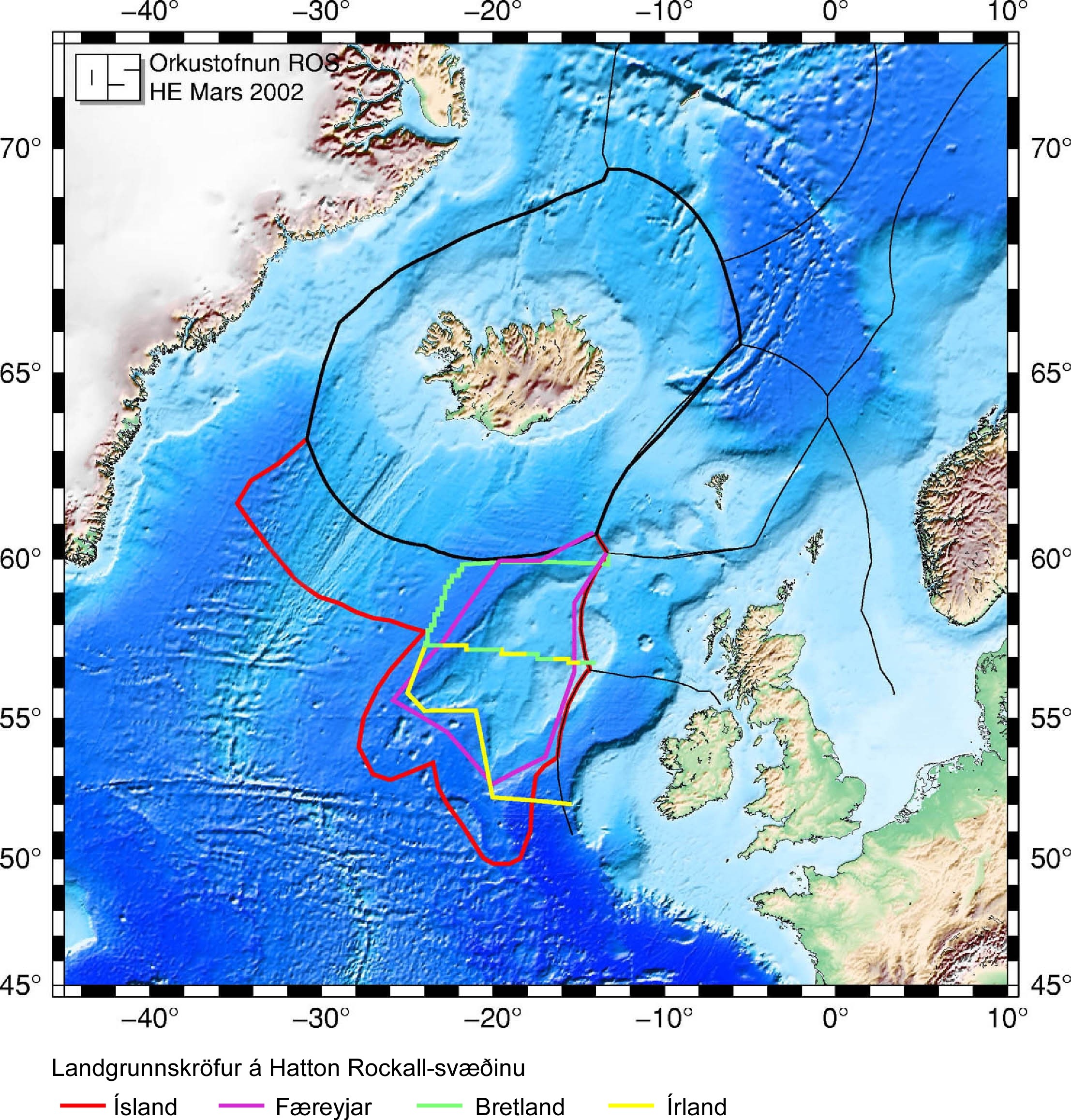
Perhaps this issue of the Hatton-Rockall Plateau should be a separate article from Rockall? quote: The Rockall Plateau is subject to multiple and extensive overlapping claims to maritime space involving Denmark, Iceland, Ireland and the United Kingdom as seen in Figure 2. When the claims are superimposed there are two large areas of trilateral overlap (Denmark/Iceland/UK and Denmark/Ireland/Iceland) and three areas of bilateral overlap (Denmark/Iceland, Ireland/Iceland and Iceland/UK) (Claims to Maritime Space). from http://www.gmat.unsw.edu.au/currentstudents/ug/projects/Irwin/irwin.htm --ClemMcGann 09:32, 26 Apr 2005 (UTC)
- In time, it may become so, but at present it really needs to be in the main article to keep it NPOV. (ps, I've promoted this segment as it really is a new sub-topic) --Red King 12:03, 26 Apr 2005 (UTC)
- so now we have a map which denies the views of Iceland and Denmark --ClemMcGann 20:43, 26 Apr 2005 (UTC)
- What?? The EEZ of the Faroes and iceland are shown. Jooler 21:32, 26 Apr 2005 (UTC)
- I suspect that ClemMcGann is having difficulty with the colour washes you have chosen for countries other than the UK - it was my reaction at first too. Can you have look at toning them up and the UK down, to achieve NPOV. My boredom threshold couldn't stand another meta war. --Red King 22:01, 26 Apr 2005 (UTC)
- I chose pink for the UK (old British Empire colour), green for Ireland, orange for Faroes and blue for Iceland. The colours are at the same intensity, but the red shows up more because of the pale colour of the continental shelf. Red/pink also contrasts more with the blue seabed. Jooler 22:15, 26 Apr 2005 (UTC)
The island is ... part of Scotland for administrative purposes.
"The island is considered by the UK to be part of Scotland for administrative purposes." (sic!) Is this a Monty Python sketch? Right you 'orrible puffins, hand over yer poll tax!!! I think it is time that the retired general came on to say that this sketch is getting too silly and ordered it to cease! --Red King 22:08, 26 Apr 2005 (UTC)
- That was added by user:MacRusgail. I have removed it. Jooler 10:25, 27 Apr 2005 (UTC)
- and now we are treated to "Rockall", which is taken from [5]where I read: [6] Please note: the Works of Flanders & Swann are copyright material and may not be reproduced or performed without the consent of THE FLANDERS & SWANN ESTATES. --ClemMcGann 10:02, 27 Apr 2005 (UTC) I trust that Jooler did obtain this consent. However it is imo reducing this article to ridicule
- That's not where I sourced the text, but in any case lyrics can be published under fair use. Why do you say it is reducing the article to ridicule? The song is about the British annexation of the rock and if you read it is actually pouring scorn on the concept of claiming it "for the Empire". Jooler 10:14, 27 Apr 2005 (UTC)
- A very revaling answer
- A link on the page has the text, yet Jooler sourced it elsewhere --ClemMcGann 18:56, 27 Apr 2005 (UTC)
- What? Jooler 19:09, 27 Apr 2005 (UTC)
- The island is a part of Inverness-shire, and should be in the standard format. This is actively administered as a UK territory: it is a UK territory. What about the articles on Quemoy and Matsu? Quemoy and Matsu are held by the ROC and claimed by the PRC; they are but miles from its coast. The only person to have resided there is a Brit: this is as much a British territory as Westminster.
- It is not. An uninhabitable rock in international waters cannot form part of any territory. Waveland will resume their occupation in a couple of weeks time. The only actual resident was a Celtic monk. Who, apparently, reported to an Icelandic Abbot. Well that is the legend anyway. What should be of concern is the Icelandic claim which is not the well articulated in the article, that the Rockall trough ends the Irish and British continental shelf. --ClemMcGann 22:44, 2 Jun 2005 (UTC)
- This is actively administered as a UK territory... How the heck does the UK "actively administer" a remote, uninhabited rock? When there is someone there--when the "Waveland" people sit on it, the UK government ignores them. How is that actively administering anything? Jonathunder 02:24, 2005 Jun 3 (UTC)
- Inverness-shire Council's legislation does apply to it.
- In what way? Does it collect poll-tax off the gannets? empty the bins of guano? check for asylum-seeking ptarmigans escaping from Iceland? fill in the pot holes on the gulf stream? --Red King 11:40, 3 Jun 2005 (UTC)
- If you read the article, the Waveland hippies weren't the only people to have ever 'lived' on Rockall; some SAS guy did in 1985 (see here). Rockall is de facto British territory, and no other country now disputes this; their disputes are surrounding the ownership / EEZ rights on the underlying continental shelves. If Rockall were to be recognized as an island, owned by the UK, then the UK would own all mineral rights etc around it (I think it's 200 miles?). As it is not recognised as an island (due to the Law of the Sea saying bare rocks don't have EEZs), then it's a moot point. It's owned by Britain, but doesn't affect ownership of the underlying seas. The exploration rights of the area around Rockall are shared between Britain and the ROI. Iceland also want the area, but Iceland would lay claim to the Mediterranean if it could. They're a right bunch of bastards who encroach sea areas and then over-fish British, Canadian and Irish fishing zones on a regular basis. Proto 13:31, 8 Jun 2005 (UTC)
- Proto, Rockall isn’t a territory of any country. It is not ‘owned’ by Britain, or by anyone else. It is an uninhabitable rock. By signing the Law of the Sea, the British acknowledged that fact. If Rockall was habitable then it would be Irish, as it is nearer to the Donegal coast than to Scotland. ‘Island hopping’ is not recognised in international law. However ownership does not arise. The present dispute over the sea bed, with Ireland and Britain on one hand and Iceland and the Faeroes on the other hand; concerns where the continental shelf ends. The Rockall Trough is 3,000 meters deep. The claim, which is gathering support, is that this ends the continental shelf. If so, neither the Irish nor the British have any rights. The Irish response is to seek a postponement of the decision from 2006 to 2009 and to spend money surveying the Trough. If there is a shallow then such a claim can be challenged. --ClemMcGann 13:55, 8 Jun 2005 (UTC)
- The Law of the Sea specifies that uninhabitable rocks do not qualify to act as an extension of a nation's EEZs. This is what was acknowledged when Britain ratified the Law of the Sea. Britain still claims Rockall as its territory, however the ownership is moot when
considering EEZ areas. As Rockall (due to it being a uninhabited rock) does not affect the delineation of EEZs, the continental shelf does not fall in any nation's EEZ, and therefore the sea bed dispute has arisen. I stand by my claim that Iceland are bastards, though. Proto 14:18, 8 Jun 2005 (UTC)
- I fail to see how Britain can claim Rockall as territory while acknowledging that it has neither fishing rights nor mineral rights. In any event the claim is not recognised by any other nation. The seabed does lie in some nation’s EEZ. At present there are overlapping claims. There is an agreement between the Irish and the British. But they have yet to persuade others of its merits. Iceland and the Faeroes have competing claims. All they agree is that the Trough excludes Ireland and Britain. Iceland has now gone further and has claimed a huge chunk of the seabed to the west of Ireland, just look at the new area they now claim (or should I say Icelandic law?) on this map: [7] (scroll down to the bottom of the page)--ClemMcGann 15:49, 8 Jun 2005 (UTC)
It is correct that a very clear distinction needs to be made between the question of ownership and the one of EEZ delimination. It is undisputed that Rockall does not affect EEZ or continental shelf claims and the actual ownership of the rock does not matter the least and I actually don't understand why other countries would challenge Britains claim to ownership of this miserable place, why not let them keep it if it eases their post-colonial stress disorder. --Bjarki 16:15, 8 Jun 2005 (UTC)
- Because no one can ‘own’ an uninhabitable rock in international waters. Back in 1954, Britain asked Ireland for permission to test fire the Blue Streak missile in the area. The Irish granted permission. However the civil servant who replied added that the uninhabitable rock could not form part of any territory. It seems that the British took this reply to mean that Ireland was abandoning its territorial rights. Even if that was the case, a civil servant would not have such authority. So they decided to seize it for themselves. The initial expectation (and the claim in the law they passed) was that this meant fishing and mineral rights). The Irish position was, and is, that if it can belong to any nation, then it belongs to Ireland. The regrettable consequence of the untenable British claim is that it weakens the EEZ claim in the eyes of other nations. There is a real possibility that the idea of EEZ up to the limit of the continental shelf will be favoured by most countries. If that is accepted then the mineral rights on the rock of Rockall will belong to the Faeroes. --ClemMcGann 16:54, 8 Jun 2005 (UTC)
In Inverness-shire?
What is the evidence for the being in the former Inverness-shire? There are various sources which out it in the district of Harris whihc has never been in Inverness-shire. Sources include Haswell-Smith's The Scottish Islands,and websites on electroral boundaries [8], Scottish parliament place names [9], Harris local plan [10] --JBellis 19:53, 4 January 2006 (UTC)
- I was amused by this on the electoral boundaries site: Electoral Division 23: Obbe Contains that part of Harris lying south and west of ED 22, and includes the islands of Taransay, St Kilda and Rockall and the islands in the southern part of the parish of Harris with the exception of Berneray and Torogay. One gannet, one vote? or is there a property qualification? --Red King 18:32, 5 January 2006 (UTC)
Eymology
Just wanted to point out that Alexander MacBain’s An Etymological Dictionary of the Gaelic Language (1896) is a somewhat...um...speculative work at times and isn’t the best reference for ordinary meanings of Gaelic words.
Stòr-dàta Briathrachais Gàidhlig entry for ròcail
- corrugate ròcail
- croak ròcail
- croaking ròcail fem
- hawing ròcail fem
- mangle ròcail
- roaring ròcail fem
- tear ròcail
Ewen MacEachen’s Gaelic Dictionary (1842) gives both of these
- Ròcail, -te, -ladh, a.v. and n.v. tear, mangle.
- Ròcail, -ladh, n.v. croak, roar hoarsely.
—Moilleadóir 10:17, 21 Jun 2005 (UTC)
Just exactly how far from anywhere is it?
An anon editor changed
- Rockall is 480 km (298 miles) from Ardnamurchan Point on the Scottish mainland and is 320 km (200 miles) from Saint Kilda,
to
- Rockall is 462 km (287 miles) from Ardnamurchan Point on the Scottish mainland and is 301 km (187 miles) from Saint Kilda,
today. Can anyone provide a reliable source for either version?
It ought to be calculable given we know the long/latitude. I'm not certain of the maths though. Graldensblud 5 May 2006 21:55 GMT+1
A GPS was used by me to measure the distances. My GPS is reasonably accurate. As proved when I contacted the National Land Survey of Iceland. From Sula Sgeir, Western Isles to Hvalbakur, Iceland is 717722 metres; my GPS calculates 717.7 km. From Sula Sgeir, to Hvalnes, Iceland is 737431 metres; my GPS calculates 737.5 km. From Sula Sgeir to Stokksnes, Iceland is 737659 metres; my GPS calculates 737.7 km. So, my GPS is accurate to within 100 metres. The maps I use are Ordnance Survey 1:25000. My method is to measure grid references with a ruler. Then using O.S's coordinate converter to convert to ETRS89 (WGS84). I used O.S's Memory-Map, which confirms the accuracy of my measurements. Anon
ClemMcgann claims that ""island hopping", the (international) legality of which is doubtful." However: "United Nations Convention on the Law of the Sea". Article 121. "2. Except as provided for in paragraph 3, the territorial sea, the contiguous zone, the exclusive economic zone and the continental shelf of an island are determined in accordance with the provisions of the conventions applicable to other territory. 3. Rocks whch cannot sustain human habitation or economic life of their own have no exclusive economic zone or continental shelf." Rockall is approximately 198.1 nautical miles from Aird An Runair permanently inhabited island of North Uist (approximately WGS84 Latitude North 57 Degrees 36 Minutes 9.7 Seconds, Longitude West 7 Degrees 32 Minutes 56.4 Seconds). This website proves the accuracy of my GPS: http://www.movable-type.co.uk/scripts/LatLongVincenty.html Sulasgeir 17:02, 21 May 2006 (UTC)
Geoscience Australia, distance calculations: http://www.ga.gov.au/geodesy/datums/vincenty_inverse.jsp Sulasgeir (talk) 12:37, 25 February 2008 (UTC)
Map of Exclusive Economic Zones
I see Jooler made a great image showing the location of Rockall. However, I notice that that in this image, the Exclusive Economic Zone for the UK does not include the area of the Irish sea near Northern Ireland. Is that correct? I would assume that the UK economic zone would include those waters but I am not positive. Thanks, Johntex\talk 00:58, 15 September 2005 (UTC)
- The map follows the zone indicated on http://www.seaaroundus.org/eez/summaryInfo.aspx?EEZ=826 as closely as possible. Jooler 06:34, 15 September 2005 (UTC)
- The problem with the map is that it represents the areas agreed between Ireland and Great Britain. The areas claimed by Iceland and Denmark overlap with these.
- As for Northern Ireland, there was a little legal nicety. The Act setting up Northern Ireland specified only the "six counties" omitting the sea. This was raised in a court case over illegal fishing. It seems that strictly speaking the waters around Northern Ireland were not British! The trawler captain, thank to a smart lawyer got off! So a hasty agreement between Ireland and Britain had to be entered into. So now those waters are "administered" by Britain. The Republic has said that it does not intend to exercise any claim over them and agrees to British administration --ClemMcGann 12:30, 15 September 2005 (UTC)
Does anyone have a map showing what the zoneswould be if Rockall was counted in the calculations? Conglacio 07:39, 2 March 2006 (UTC)
Photo
I've just been on a fisheries survey to the area, and we had unbelieveble weather, so managed to get really close to the rock and I got a good picture. If anyone's interested, the fish stocks are still assessed by Scotland, but as it's beyond the 200 mile limit, there's no longer management of catches. Anilocra 10:49, 16 September 2005 (UTC)
- My compliments on the photo - wonderful! --ClemMcGann 16:02, 16 September 2005 (UTC)
- Thanks a lot for contributing the photo; I imagine appropriately-licensed pictures of Rockall would be difficult to come by otherwise and yours is a great photo that really adds to the article! — Trilobite 17:28, 20 December 2005 (UTC)
?
Why are we deciding what Rockall is best known as? Why is it unacceptable to say that Rockall is an islet AND a shipping forecast zone that has some cultural meaning? I'm confused. --Bjarki 00:45, 18 September 2005 (UTC)
- Indeed! If you have the patience for yet another edit war with Jooler and his strange anglocentric world view, go ahead. Sane people would regard the reference to the BBC Shipping Forecast as worth at best a footnote. --Red King 19:08, 19 September 2005 (UTC)
Um... this is tiresome. Plenty of Irish and Icelandic fisherman listen to the BBC Shipping Forecast. But it has a cultural impact far beyond its intended audience. Take a look at these book at Shop Ireland - [11] - Charlie Connelly's book is top of the list a reviewer for the Sunday Tribune wrote "Went down a storm with this sea lover. It has great humour, it has great atmosphere. A very entertaining read and, believe me, you'll never see cod in the same way again" [12]
Dylan Moran is from County Meath he wrote Black Books in one episode of which one of the characters read the Shipping forecast,
Seamus Heaney is from Derry..
- 'Dogger, Rockall, Malin, Irish Sea ;
- Green swift upsurges, North Atlantic flux
- Conjured by that strong gale-warning voice
- Collape into a sibilant penumbra
- Midnight and closedown
- Sirens of the tundra
- Of eel-road, seal road, keel road, whale road
- Raise their wind compounded keen behind the bays
- And drive the trawlers to the lee of Wicklow
- L'étoile, le guillemot, la belle helène,
- Nurse their bright names this morning
- In the bay that toiled like mortar
- It was marvellous and actual:
- I said, out loud: 'A haven!'
- The word deepening, clearing,
- Like the sky elsewhere on Minches, Cromarty, the Faroes
- As for me, my mother is from Donegal and my father is from Leitrim. Jooler 20:06, 19 September 2005 - I suggest you re-read this talk page and and note what kind of "anglocentric world view" I actually have. (UTC)
I don't object to mentioning the BBC shipping forecast, it is quite important for sure and so is the cultural impact of it even though I had no idea about it until I read it in this article. What I don't understand is why Jooler reverted my edit where it said is also known as to is probably better known as with the lenghty edit comment: sigh, it's not the Shipping Forecast itself or the people who listen to it, but the cultural impact from it, i.e poems by Seamus Heaney, songs by Blur etc.. A comment I can't understand how is related to the edit in question, which involved one word. Frankly, I could not care less about the way this sentence is phrased, what annoys me is when editors become so posessive of articles that they revert the same sentence over and over again instead of trying to discuss the dispute on the talk page, this goes for both Red King and Jooler. --Bjarki 22:42, 19 September 2005 (UTC)
- What I don't understand is why you felt that it needed changing? Red King removed it in ignorance of the significance of the Shipping Forecast and I had to revert twice then you immediately changed it again. The edit summary seemed a suitable place to re-inforce my point about its significance. Jooler 00:45, 20 September 2005 (UTC)
- I just don't see how it can be claimed that Rockall is more widely known as a sea area of a shipping forecast, even with all its proclaimed cultural impact, cultural impact that is negligible outside the British Islands. But have it your way, you don't need to cite any more poems for me. I just saw a opportunity to make the article slightly better in my opinion and I used it, perhaps I was simply wrong. In any case I'm moving on. Cheers. --Bjarki 01:18, 20 September 2005 (UTC)
- The cultural impact, poetry song etc.. is certainly larger that the impact of a speck of rock in the middle of the sea. Jooler
- I furiously disagree and put forth the ultimate argument that I am right and you are wrong. :) --Bjarki 01:56, 20 September 2005 (UTC)
I didn't remove anything. I simply added "to British listeners" to provide a context for the world-wide readership of wikipedia. I don't impugn the cultural associations that go with the BBC Shipping Forecast, but it is not the only such forecast anywhere in the world. I suppose I could have put listeners to the BBC Long Wave Service and readers of Seamus Heaney and other writers but not E. Annie Proulx, but that would be pedantic. In the end, I didn't care enough to start a debate about it - on past experience, there is either Jooler's way or the wrong way and it's not an issue that is worth the bandwidth to argue about it. --Red King 13:41, 20 September 2005 (UTC)
- 1. we have shipping forcasts in Ireland too, and not the bbc ones....
- 2. dylan moran lives in England
- 3. which shipping forcast was heaney who lived in Northern Ireland (where you get the bbc radio stations) refering to... Owwmykneecap 00:29, 27 July 2006 (UTC)
- The RTE sea area forecasts supplied by Met Éireann (http://www.met.ie/forecasts/sea-area.asp) focus on coastal waters. Fishermen from all countries who fish areas like Rockall rely on the UK Met Office forecasts. Jooler 08:20, 27 September 2007 (UTC)
Spanish wreck
I'm curious about the 1686 wreck of a Spanish ship on the rock. Does anyone have more information on this incident? Bastie 04:34, 21 September 2005 (UTC)
No wonder you are curious about it, as it is a real non-sense that a Spanish ship bound for America sailed anywhere remotely close to Rockall. The real thing is as follows:
Martin Martin's A late voyage to St. Kilda, published in 1698 includes the following:
[St. Kilda inhabitants] are charitable to strangers in distress, this they had opportunity to express to a company of French and Spaniards who lost their ship at Rokol in the year 1686, and came in, in a pinnace to St. Kilda, where they were plentifully supplied with barly-bread, butter, cheese, solan geese, eggs, etc. Both seamen and inhabitants were barbarians one to another, the inhabitants speaking only the Irish tongue, to which the French and the Spaniards were altogether strangers; upon their landing they pointed to the west, naming Rokol to the inhabitants, and after that, they pointed downward with their finger, signifying the sinking and perishing of their vessel; they skewed them Rokol in the sea map, far west off St. Kilda. This, and much more, the masters of these ships told to a priest in the next island who understood French. The inhabitants acquainted me that the pinnace which carried the seamen from Rokol was so very low, that the crew added a foot height of canvas round it all, and began to work at it upon Sunday, at which the inhabitants were astonished, and being highly dissatisfied, plucked the hatchets and other instruments out of their hands, and did not restore them till Monday morning.
That's all. One can only guess that if the ship's crew was really a mix of Frenchs and Spaniards perhaps it was a fishing boat bound for North Atlantic cod fisheries; and in this case most probably that people was based in some of the Bay of Biscay ports.
I will modify the article in this way. —Preceding unsigned comment added by Buron444 (talk • contribs) 16:26, 31 December 2007 (UTC)
Remotest Island
The register (http://www.theregister.co.uk/2005/04/08/rockall_ho_charity_appeal/) claims that Rockall is the remotest island in the world. I've no idea if this is true.
- if it is true - then it should be said --ClemMcGann 15:42, 8 Apr 2005 (UTC)
- I don't find this totally unbelievable but we should find at least one more source for this before we present this like a fact in the article. --Bjarki 17:42, 8 Apr 2005 (UTC)
- they have some great pics on their (Rockall Times) site, if anyone feels like sending them a begging e-mail to contribute it under GNU GL to Wiki Commons. --Red King 21:16, 8 Apr 2005 (UTC)
- Remotest? For this claim to be true they would have to be using a strange definition of remote. Pitcairn and Tristan da Cunha are both a lot farther from a populated country. And there are plenty of unoccupied islands in the far south that are even more remote. For instance Bouvet_Island#Geography. -- Geo Swan 07:23, 2005 Apr 23 (UTC)
- I'll see your Rockall, less than 200km from St Kilda, and raise you a Bouvet Island:
- "Bouvet Island is a candidate for the most remote island in the world, along with other small insolated islands such as Tristan da Cunha, Easter Island and the Pitcairn Islands. The nearest land is Queen Maud Land, Antarctica, over 1,600 km (1,000 miles) away to the south, which is itself uninhabited."
- So, let's remove the claim. -- Geo Swan 19:33, 15 July 2005 (UTC)
- I'll see your Rockall, less than 200km from St Kilda, and raise you a Bouvet Island:
![[13]](https://en.wikipedia.org/wiki/Image:Bouvet_Island.png)
My understanding is that Rockall is the "remotest" island in the world, where "remotest" is (implicitly) defined as being the furthest from any other inhabited land (island or continent). Val42 18:21, July 15, 2005 (UTC)
- There are rocks and even islands that are much more remote than Rockall. Jonathunder 18:41, 2005 July 15 (UTC)
Okay, I went and re-read the article. The relevant part of the article says, "... Rockall - the world's remotest islet," where "islet" references a footnote. The footnote says, "No emails, please. Rockall really is the world's remotest island, lying the furthest distance from any other outcrop or land of any description. 'Tis true." Meriam-Webster defines "islet" as "a little island". Apparently, the definition from UnHoly is what they are using. But you'll have to talk to the Register or the Rockall Times for clarification. Val42 19:06, July 15, 2005 (UTC)
1955 (1974) photo with sentry box
http://en.wikipedia.org/wiki/Image:Rockall.jpg
This looks rather like a spoof photo - wher edid it come from? Compare with the photo on the BBC website for the same year [14]--JBellis 19:36, 30 April 2006 (UTC)
- The top line on the page asks about the same image - and links to The RockallTimes - therefore I think that we can safely assume it's a joke.--JBellis 19:39, 30 April 2006 (UTC)
Hi - see here http://www.telegraph.co.uk/arts/main.jhtml?xml=/arts/2004/05/29/bocon29.xml&sSheet=/arts/2004/05/30/bomain.html 5th-last paragraph makes reference to. Am in process of ammending date - i did get that wrong —Preceding unsigned comment added by Graldensblud (talk • contribs)
- The photo referenced at the top of the page is genuine. It has featured in the Telegraph at least three times. I emailed the Telegraph about it ages ago and they sent me a proof of the image. But AFAIK the rights to the image are held by the MoD. I emailed the MoD and and the Royal Marines Photo archive or something like that, but I just drew a blank. The picture was first published in 1974, but it had actually been taken 10 years earlier. On the proof it says it was last published on 15/07/2004, If anyone wants to pursue the rights to this image, the Telegraph's reference for the image is TG*1891175 Jooler 10:34, 5 May 2006 (UTC)
Image copyright updated to "promotional publicity photo", since its from 1974 according to the Telegraph - if the MOD have allowed it publication repeatedly i suspect that counts as press-release-derived? And the whole event clearly was done for show. Graldensblud 5 May 2006 19:55 GMT
- I'm wrong about the dates - The photo was taken in 1974 and first published 10 years later. On http://www.therockalltimes.co.uk/rockall/history.html it says "In 1974, the UK decided that no one else was allowed within 50 miles of Rockall and the shit really hit the fan. Brilliantly, the navy installed a temporary sentry box and flag and stuck two Royal Marines in full ceremonial dress next to it to guard it. The picture was only released 10 years later as part of another celebration of the rock's Britishness." I don't know whether the image qualifies as you suggest. It's probably worth pursuing with the MoD or whoever though in order to get a better quality image. Jooler 01:32, 6 May 2006 (UTC)
The picture is amusing, but an obvious spoof and as currently presented, highly misleading. The shadows don't tally with the light in the rest of the picture, and the two guards and their box appear to be floating a few inches off the surface of the rock -- just as well since the surface is so uneven they would have had severe problems erecting it, let alone holding it down and preventing it being blown off the rock. The phrase "temporary sentry box" made me smile: I imagine any such flimsy structure would turn out to be very temporary indeed. The picture doesn't appear in the Telegraph article linked to above, was it supposed to? Compare it with the obvious realism of the pictures on this and the BBC page. Whether the writer of the article knew the picture was a spoof or had even seen it is a matter of speculation, but the fact that he refers to "two Royal Marines in ceremonial dress and bearskins", when the men illustrated are not wearing anything remotely resembling bearskins (the uniform of the Grenadier Guards I believe) may tell us something about how seriously we should take this kind of light-hearted anecdotal journalism. Also, if the photo was taken (at enormous expense and some physical risk) for propaganda purposes, why on earth would the British government then stick it in a drawer and wait ten years to publish it? If no-one can establish where it came from or what light it sheds on the subject it should be deleted -- with a smile, but this is supposed to be a serious article after all. In the meantime I've toned down the caption, but this is intended as a temporary measure -- preferably as temporary as a wooden sentry box perched on a windswept chunk of rock in the North Atlantic. Flapdragon (talk) 13:15, 2 May 2008 (UTC)
It seems to me that the bottom of the sentry box is filled with white sandbags. Does anyone else agree? If so, this would give it some stability, enough for a photo shoot. Bear in mind, when talking about this photo, that photoshop style programs weren't really around at the time this picture dates from. If it were to be a spoof the faking would have had to be done using compilcated techniques with the negatives. It's very unlikely they would have managed to produce anything this plausible. munchingfoo —Preceding undated comment was added at 11:04, 29 October 2008 (UTC).
British Rockall
Apologies in advance before the editing police get here. Couldn't resist it. MarkThomas 08:45, 28 June 2006 (UTC)
- You're a funny guy. --Bjarki 08:50, 28 June 2006 (UTC)
- I know. :-) Wading through all the international law drivel on this page, it does seem conclusive that it belongs to the Brits, but it's nearer Ireland, so maybe Britain and Ireland should toss a coin. MarkThomas 09:05, 28 June 2006 (UTC)
- True, there are more important issues have been solved in that way before. --Bjarki 09:17, 28 June 2006 (UTC)
- As I understand it, there's no serious debate on the ownership of Rockall itself -- all the involved governments recognize that it's inside UK waters. But nobody's really interested in Rockall; the real dispute is over the surrounding seabed (and its natural resources). Demiurge 09:23, 28 June 2006 (UTC)
- Being serious for a moment, I think it's kind of both; whilst there is no per se dispute that the rock is British, the fact that many nations claim that patch of sea implies a challenge to the rock, since if the rock was categorically UK property, the other countries would have no claim. It's a bit like the Falklands argument. What probably needs to happen is an international convention, but presumably the countries concerned resist this for fear of losing; instead it makes sense politically to keep saying "we own that" in the hope that one day when the oil price rises enough they can all scrabble to build rigs there and de-facto take control. Once can only hope that some sense eventually prevails as with all these pathetic neo-imperialist disputes between "governments" that are hardly intelligent enough to piss in a pot. MarkThomas 11:14, 28 June 2006 (UTC)
- Bog off "Britain", let Scotland have it - although if you return all the oil money stolen from us, we may be open to negotiation. --MacRusgail 23:28, 24 August 2007 (UTC)
Scotland is part of Britain and so is Rockall. The Republic of Ireland has given up its vile claim to Northern Ireland now it's about time they did the same to this other part of the United Kingdom they are STILL offensively claiming! YourPTR! 23:41, 24 August 2007 (UTC)
- "Vile claim." How do you work that one out? The entire island was idependant until British invasion. I suppose by your logic the British occupation of the entire island was completely justified and legitimate, and the Irish were being "vile" for wanting independance.
- I'm no expert on that matter but didn't the republic remove from its constitution the claim to the whole island back in 1998? As for Rockall, its ownership is completely meaningless as it has no effect upon the delimitation of either EEZs or the continental shelf. --Bjarki 23:50, 24 August 2007 (UTC)
- Yes, see Nineteenth Amendment of the Constitution of Ireland. --Red King (talk) 20:17, 25 February 2008 (UTC)
- I'm no expert on that matter but didn't the republic remove from its constitution the claim to the whole island back in 1998? As for Rockall, its ownership is completely meaningless as it has no effect upon the delimitation of either EEZs or the continental shelf. --Bjarki 23:50, 24 August 2007 (UTC)
Frost
"After the 1955 UK annexation, David Frost on BBC satirical show That Was The Week That Was coined the phrase "Sweet Rockall".[6] " - [TW3]] - was broadcast in 1962/63 some 7 or 8 years after the annexation - the usage in the PDF from which this is sourced reads "Coverage of the story with photos of the Union Flag flying above ‘Sweet Rockall’ e as David Frost referred to it on the BBC’s satirical That Was the Week that Was" it should probably read "Coverage of the story with photos of the Union Flag flying above ‘Sweet Rockall’ e as David Frost [would much later refer] to it on the BBC’s satirical That Was the Week that Was" In any case i'm removing the rather boring tidbit. Jooler 22:49, 6 November 2006 (UCT)
- I have reinstated it, why do you think it is more boring and worthy of deletion than all the other unsourced tipbits? --Philip Baird Shearer 22:54, 14 July 2007 (UTC)
Exclusive economic zone - evidence
The opening paragraph has an uncited claim that Rockall is in the EEZ of the UK and that this is undisputed by its neighbors. Is there any evidence for this claim? I think that there is more evidence against it. For example, the minutes of the UK House of Lords for 3 June 2003 says[15]
- Marine Protected Areas
- Lord Hunt of Chesterton asked Her Majesty's Government:
- Given that the required legislation is not yet in place, what the calendar will be for the implementation of the recommendations of the 2002 World Summit on Sustainable Development on marine protected areas for the United Kingdom's exclusive economic zone.[HL2961]
- Lord Whitty: While the United Kingdom has not declared an Exclusive Economic Zone, this does not affect the rights that the UK may assume as a coastal state in accordance with the United Nations Convention on the Law of the Sea, including an obligation to protect and preserve the marine environment.
which also seems to suggest that the map is a figment of someone's fertile imagination! If the UK hasn't even asserted an EEZ, it can hardly have negotiated with its neighbours the dividing lines where 200 mile limits overlap. 88.97.11.54 11:28, 26 June 2007 (UTC)
- But now I've found "Statutory Instrument 1997 No. 1750 - The Fishery Limits Order 1997" which seems to do exactly that! It relies on the baseline of Saint Kilda to enclose Rockall in one of its 200nm arcs. 88.97.11.54 12:07, 26 June 2007 (UTC)
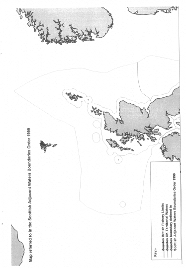
- SI 1750/97 incorporated the 200nm fishery limits from UNCLOS into UK legislation. As a Fishery Officer myself, I can confirm that British Fishery Limits (BFL) do incorporate Rockall within the 200nm arc from St Kilda. SI 1126/99 The Scottish Adjacent Waters Boundaries Order 1999 agreed adjacent boundaries on the formation of the Scottish Parliament, a map is also provided with the SI. This clearly maps out the Scottish area of the BFL which includes Rockall. Certainly, the Scottish government do not see any difference between the EEZ and BFL as seen in the first line of this document. Does this help clear this up? --Liam Mason 15:05, 5 July 2007 (UTC)
---
But just to make it interesting, the Sea Around Us Project at the University of British Columbia has maps of the UK[16], Irish[17], Faroese[18] and Icelandic[19] EEZs that seem to agree with the map on wikipedia. But then again UBC haven't given their sources! 88.97.11.54 11:28, 26 June 2007 (UTC)
---
Ireland has legally defined its EEZ, it's in the "Sea Fisheries and Maritime Jurisdiction Act 2006", section 81. But it merely repeats the UN Treaty that the EEZ is 200 miles beyond the baseline except that, in areas of overlap with another jurisdiction, the delimiting line is the midpoint of the distance between the respective baselines. 88.97.11.54 11:45, 26 June 2007 (UTC)
Map links - what for
What are those map links (Wikimapia, Terraserver) good for? There is absolutely nothing to see.--Ratzer 06:23, 27 July 2007 (UTC)
North American Plate?
I really don't think Rockall is on the North American Plate, can someone more knowledgeable than me check it out? —Preceding unsigned comment added by 88.105.62.5 (talk) 21:03, 19 September 2007 (UTC)
      It seems Rockall sits on the Rockall Plate, which is to the east of the Mid-Atlantic_Ridge,
      the illustration there showing the ridge as well to the west of the Rockall Bank.
      North_American_Plate confirms this, the map clearly showing that the plate boundary is
      indeed far to the west of Rockall. It seems that the Rockall plate may have once been part
      of the North Americam Plate, but is now linked to the Eurasian Plate.
      Rambler24 06:57, 24 September 2007 (UTC)
- I've deleted that claim. Rockall is clearly to the east of the Mid Atlantic Ridge, and is therefore not on the North American Plate. A brief Google search gave some results that indicating that - based on the rock chemistry - it may have originally been part of the the NAP - however, that is not what people would normally mean when they say what plate it is on. I would have thought it was instead on the European Plate, but as the previous comment mentions the Rockall Plate (which I had not heard of previously), I'll leave it to someone with more geological knowledge to specify. Wardog (talk) 12:28, 27 November 2007 (UTC)
Yes But.........
A fascinating debate, but I have just one question - where is it?
At the top of the page, the coords are given as 57°59′67″N, 13°68′86″W - now my mammy always taught me there were 60 seconds in a minute, and sixty minutes in a degree,so where do the 67″ 68′ 86″ come from?
Lower down, in the Geography section it's given as 57°35′48″N, 13°41′19″W, which is the location given in The Rockall Times and confirmed by their GPS reading. Rambler24 19:50, 23 September 2007 (UTC)
- The former coordinates are actually decimal degrees but formatted (incorrectly) like conventional coords. --Bjarki 20:10, 23 September 2007 (UTC)
Reykjavík conference
I have removed the date at the beginning of this section. How on earth can delegates have met in a month that has yet to happen? 17.38 29/09/2007. —Preceding unsigned comment added by 80.238.8.128 (talk) 16:38, 29 September 2007 (UTC)
- A new meeting has now been held in Copenhagen. See: http://www.iht.com/articles/ap/2007/11/02/europe/EU-GEN-Ireland-Atlantic-Oil.php --Bjarki 16:40, 3 November 2007 (UTC)
Location within the UK
Is Rockall considered part of Scotland? It's not clarified in the article.
It's part of Na h-Eileanan Siar (Western Isles) in Scotland. 130.132.200.86 (talk) 04:35, 2 November 2008 (UTC)
- That is under UK Law, Iceland and Denmark have another opinion ClemMcGann (talk) 13:01, 2 November 2008 (UTC)
None of the aformentioned claims of sovereignty are valid
Claiming an island does not make it yours, be you Joe Smith or the Queen of England. What makes it property, is a permanent and defended presence on it. As there are none, no country can rightfully claim an EEZ over the area.
The only group that could claim it, and only for the time of their presence, was Greenpeace, which occupied it for a few weeks some decades ago. They then abandoned their post, thus any claim after this time became invalid.
This is the way it has always been, with law the law of the sea. Unlike Sealand it is a natural geographic formation, and not a man-made structure, and therefore does have territorial waters, if it were properly claimed.
Until the UK, or anyone else builds a permanent and defended post upon the island, no claim to an EEZ is valid.
If I were to go build a concrete bunker on rockall, live in it and defend it with one rifle, I could claim myself Sovereign of Rockall, and rule the rock and its EEZ. That is, until the UK or someone else removed me by force through an act of warfare. If I had a spare million dollars I am just eccentric enough to do exactly that. Bobkeyes (talk) 21:20, 5 February 2008 (UTC)
- Nobody is claiming EEZ based on Rockall and the rock is already within the British EEZ. The dispute is about extended continental shelf rights where the sovereignty/ownership over the rock itself is irrelevant. --Bjarki (talk) 21:48, 5 February 2008 (UTC)
Names of the states making claims.
There is a bit of an edit war over the correct names of the states making claims on the shelf rights, specifically the name of the Irish state. The name of the Irish state is Ireland. It has the additional description "Republic of". The name of the Icelandic state is Iceland. It has the additional description "Republic of". The name of the Danish state is Denmark. It has the additional description "Kingdom of". If the basis for the United Kingdom claim was 200nm from somewhere in Northern Ireland, I could accept that disambigution is needed, but as it isn't, it isn't. So unless we are going to use the pedantic long forms forms for all the states (including "United Kingdom of Great Britain and Northern Ireland"), let's just stick to the short forms used in international law. --Red King (talk) 00:43, 14 February 2008 (UTC)
Help - which country is Rockall?
##Rockall is within the exclusive economic zone (EEZ) of the United Kingdom.## ~If this means that Rockall, i.e. the bit that sticks out of the sea, is part of the UK, shouldn't the article say so?
##In 1997, the UK ratified[4] the United Nations Convention on the Law of the Sea and thus relinquished any claim to an extension of its EEZ beyond the islet.## ~OK, so the focus has moved off the rock, and onto the economic zone surrounding the rock, but what about the rock - is it part of the UK? Is it de facto and de jure administered by the UK as is, say, bass rock?
##The remaining issue is the status of the continental shelf rights of surrounding ocean floor. ## ~Well, lets be perfectly frank, the real remaining issue of interest in this introductory paragraph is of which country is Rockall (the bit that sticks out of the sea) a non-contiguous piece. There seems to me to be no good reason why this information is being ignored? —Preceding unsigned comment added by 217.33.134.254 (talk) 12:22, 30 April 2008 (UTC)
- Rockall is not part of any country. If it was, it would have its own EEZ. Putting Rockall within the UK EEZ was just agreed with Ireland. Iceland and Denmark have yet to agree. You might find this map interesting [20] It has Iceland claiming sea to the west of Ireland, leaing the rest to the Faroes (Denmark) ClemMcGann (talk) 13:49, 30 April 2008 (UTC)
- EEZ can never be claimed on the basis of an islet like Rockall so it is completely irrelevant who owns it. As far as I know, only the UK actually claims ownership of Rockall. --Bjarki (talk) 21:22, 30 April 2008 (UTC)
- There have definitely been ownership disputes; I'll see if I can remember where I've seen those referred to online, for everyone to consult; somewhere deep in BBC News there should be a piece about Denmark claiming it. And for that matter, see also where a Greenpeace / SchNEWS activist occupied it... – Kieran T (talk) 22:12, 30 April 2008 (UTC)
- EEZ can never be claimed on the basis of an islet like Rockall so it is completely irrelevant who owns it. As far as I know, only the UK actually claims ownership of Rockall. --Bjarki (talk) 21:22, 30 April 2008 (UTC)
- This is yet to be resolved. Ireland and Britain have an agreement. Denmark and Iceland have an "understanding". The big difference is the Rockall Trough. To Iceland and Denmak this marks the limit of the "continental shelf", so neither Britain nor Ireland can claim beyond that point. Leaving Iceland and Denmark to carve up the Rockall Plateau between them. In this "understanding" the rock of Rockall would fall into the EEZ of the Faroe Islands (Denmark). ClemMcGann (talk) 09:38, 1 May 2008 (UTC)
- Rockall is not part of any country. If it was, it would have its own EEZ. Putting Rockall within the UK EEZ was just agreed with Ireland. Iceland and Denmark have yet to agree. You might find this map interesting [20] It has Iceland claiming sea to the west of Ireland, leaing the rest to the Faroes (Denmark) ClemMcGann (talk) 13:49, 30 April 2008 (UTC)
"Rockall is not part of any country. If it was, it would have its own EEZ" Whoever wrote that - what absolute rot. Are you seriously saying that islands/islets too small to have their own EEZ have no sovereignty? That would make a real mess of the UK - there must be hundered of such islets there! The UK has exclusive fishing rights in the territorial waters around Rockall for a good reason - because that tiny islet is its territory! Just because Iceland don't like it tough. Taiwan don't like the PRC being in charge of mainland China, but so what? —Preceding unsigned comment added by 78.144.40.246 (talk) 20:16, 4 July 2008 (UTC)
How big is it?
I don't think the article says what size Rockall is. It looks small from the picture, but what are the actual dimensions? Vultur (talk) 22:04, 9 October 2008 (UTC)
Isometric map

This map, which has an arrow pointing to an undersea peak, confuses the issue, rather than enlightening. The islet itself lies somewhere underneath the lettering identifying the Rockall Plateau. However, it looks at first glance as if the islet (under some obscure name) is actually in the Rockall Trough. I would either reomove this connfusing image altogether, and just rely on the other very clear image, or, alternately, edit the isommetric image in order that less attention is given to the arrowed feature, and the location of the feature that the article is actually about is made clear to the reader.
Amandajm (talk) 11:30, 28 December 2008 (UTC)
Aaaaargh!
This is so stupid it is worthy of a place in the "Rockall Times"!
Rockall has a diameter of 27 metres (88.5 ft), a height of 23 metres (75.5 ft) and an approximate surface area of 570 m² (6,135 sq. ft.). The rock is about 25 metres (83 ft) wide at its base and rises sheer to a height of approximately 22 metres (72 ft).
We have here two totally conflicting sets of figures as to the size. Here are a couple of simple rules for encyclopedic editting.
- Find the best available source
- Cite the source that you are going with
- Don't add something without reading what it says in the same paragraph.
- Don't save without using "Show preview"
- Don't leave the artcle without double-checking that your save was appropriate.
Edits like this one make Wikipedia look like an absolute farce!
I hope one of you editors is watching this page, because I am not about to fix it! Amandajm (talk) 11:55, 28 December 2008 (UTC)
Fixed. The sources are not ideal but they are better than nothing. I could not find a source for the volume etc. so I ditched that. Ben MacDui 13:58, 28 December 2008 (UTC) PS "editing" has one "t". We all make mistakes so let's help one another rather than implying that those who do so are unwelcome.
Light beacon
- Establishing that the rock is part of the United Kingdom and its development as a light beacon...
What happened to the light beacon? Marnanel (talk) 17:33, 4 April 2020 (UTC)
- The beacon has been repaired several times, due to storm damage. Unfortunately, this appears to be a never ending task and the beacon is, at present, non-operational. The base can be clearly seen in modern photographs. Regards, David J Johnson (talk) 11:23, 5 April 2020 (UTC)
Visitations
The May 2020 planned public tour is likely not to occur as scheduled, due to COVID-19 restrictions on gatherings and travel - needs a source found to confirm this and if it is postponed to a new date. — Preceding unsigned comment added by 2001:8B0:B051:C410:C089:BE44:6EA0:ADA0 (talk) 11:00, 23 May 2020 (UTC)
Territorial waters of the Republic of Ireland in the "Real Map of Ireland"
On its website, the Marine Institute (of the Republic of Ireland) displays a map of Ireland's territorial waters https://www.marine.ie/Home/site-area/irelands-marine-resource/real-map-ireland, which it describes as "The Real Map of Ireland". This map does not support a claim (such as that added by user 109.77.87.62 on 1 July 2020) that Rockall is in the territorial waters of the Republic of Ireland. The northern boundary of Ireland's territorial waters shown on this map crosses the Rockall Bank at latitude approximately 56.8°N, but Rockall is located at 57.6°N in the northern part of the Rockall Bank, i.e. north of, and outside, the territorial waters claimed by the Republic of Ireland. GeoWriter (talk) 20:47, 1 July 2020 (UTC)
3 × Vidal
Is it correct that the name ‘Vidal’ appears for three different people? Is that all just coincidence? ◅ Sebastian 03:20, 7 September 2020 (UTC)
Another cultural reference
In TH White’s 1957 The Master, two children and a dog find themselves stranded on Rockall, which they discover to be hollow and ‘inhabited by a mysterious person who aims to take over the world.’ — Preceding unsigned comment added by 109.249.184.248 (talk) 12:56, 21 November 2020 (UTC)
- This is already mentioned, in the section In popular culture. ~dom Kaos~ (talk) 09:45, 27 November 2020 (UTC)
Locking page
Recently edits have sky rocketed here back and forth between people stating the Island belongs to Ireland or the UK. Many of these edits are done by users without accounts, presumbly motivated by recent events to do with the island.
May I propose locking the page so only users with accounts can edit the page for a time? I'd do it myself but I don't know how nor think I'm allowed to do so. Dubarr18 (talk) 19:02, 6 January 2021 (UTC)
- Absolutely agree, the majority of recent "edits" are by IPs in the Republic of Ireland - who are ignoring the fact that the Republic makes no claim to Rockall, mentioned in the lead. David J Johnson (talk) 19:08, 6 January 2021 (UTC)
Article still has bias
Does anyone else get the feeling that the following text "In 1988, the United Kingdom and Ireland signed an EEZ boundary agreement for which "the location of Rockall was irrelevant to the determination of the boundary"" is trying to mislead? I think whoever inserted that text wants the reader to conclude that 'therefore the UK does not own the rock, and the EEZ boundary is a red herring in terms of determining Rockall's ownership', but actually the text should be read literally. Yes, the rock was entirely irrelevant in determining the EEZ boundary, but when the boundary was determined Rockall was inside the UK boundary meaning, according to international law, the UK is entitled to the island (indeed responsible for it) and its territorial sea. Ireland HAVE accepted the EEZ boundary; they are cognizant of the fact that rocks and islets within EEZ boundaries belong to the EEZ owner, and therefore Rockall's position is disputed by nobody (except a lot of people on Wikipedia!). This fact comes across as somewhat diluted in this article. — Preceding unsigned comment added by 01:50, 20 June 2021 (talk) 17:50, 19 June 2021 (UTC)
Edit request
Can someone who has access to the page please edit it to correct the name of Miller Christie to Miller Christy? — Preceding unsigned comment added by 2a00:23c5:6409:5701:35a9:cbf1:c81:4995 (talk) 07:43, 1 September 2021 (UTC)
- No, your "contribution" is unsigned and unsourced. Please abide by Wikipedia conventions. Thank you, David J Johnson (talk) 11:04, 1 September 2021 (UTC)
- I've made the requested change. Multiple published sources use the suggested spelling, including this paper:
- https://ia800301.us.archive.org/33/items/scottishgeograph14scotuoft/scottishgeograph14scotuoft.pdf
- The author is Robert Miller Christy FLS
- Jean-de-Nivelle (talk) 10:21, 20 September 2022 (UTC)
Structure?
What is that human made structure on top which can be seen in the photo? https://en.wikipedia.org/wiki/Rockall#/media/File:LE_Roisin_at_Rockall.jpg 2003:C0:DF14:E400:2165:EB42:7F9C:B941 (talk) 09:25, 20 September 2022 (UTC)
- Googling suggests it may be a mounting that was used to attach a beacon that no longer exists. There's a picture here that gives a better sense of scale:
- https://hakaimagazine.com/wp-content/uploads/greenpeace-rockall-dispute.jpg
- Jean-de-Nivelle (talk) 13:04, 20 September 2022 (UTC)
- PS Here's another with the beacon intact.
- Jean-de-Nivelle (talk) 13:15, 20 September 2022 (UTC)
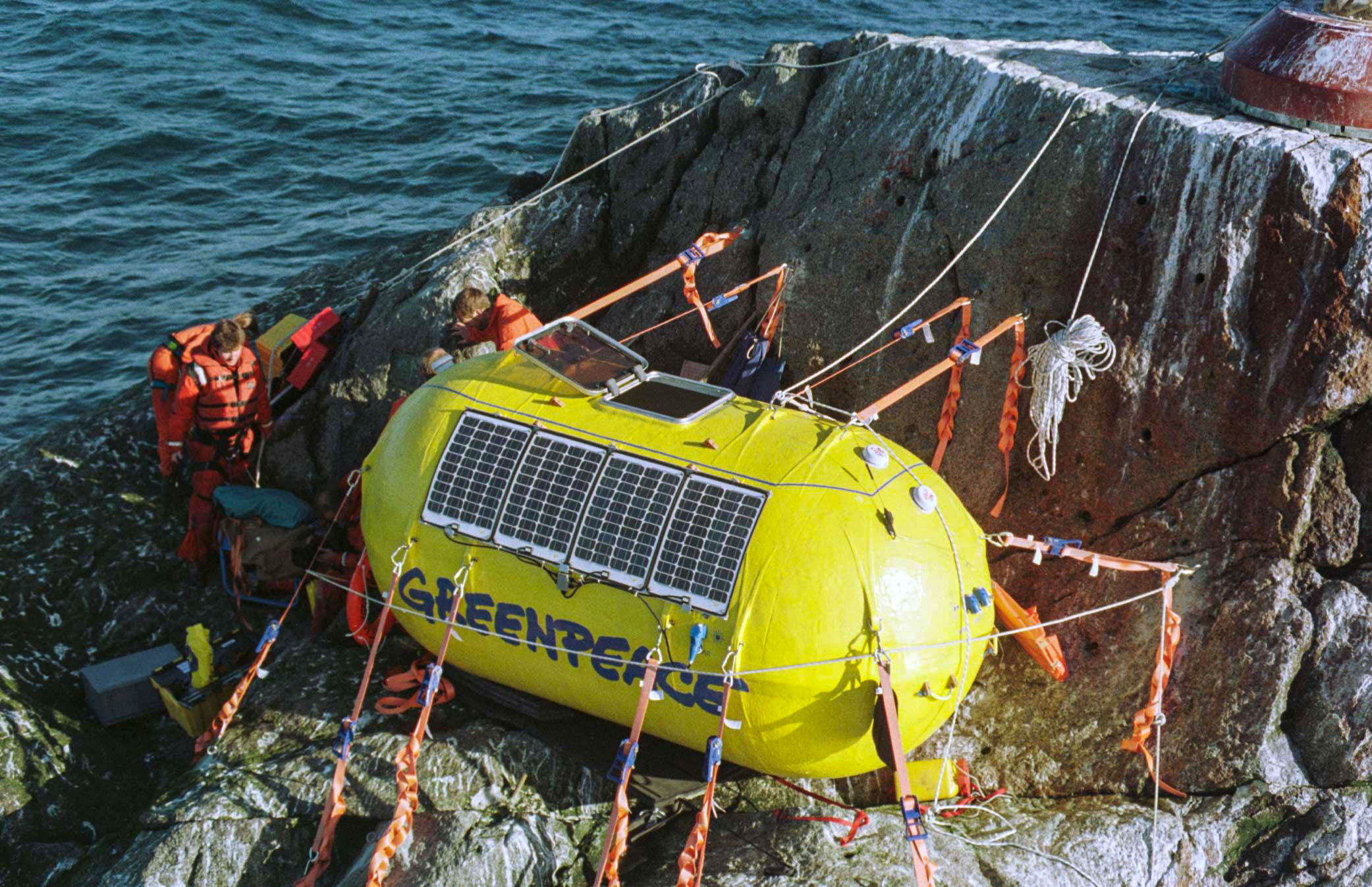
Rockall
The team attempting to stay on Rockall sail on the Taeping yacth on the 26th May 2023 .The landing team are Christhoper Cameron team leader Nobby Styles G0VJG EmilBergmann DL8JJ.We plan to operate two amatuer radio stations hf/vhf from this rare island (EU189) .Arron Wheeler film director will also be on the trip. Chris Thrill is no longer any part of this team. Nobby1133 (talk) 20:28, 31 January 2023 (UTC)
Contradictory intro
"Ireland's position is that Rockall does not even generate a 12-nautical-mile territorial sea for the United Kingdom owing to the UK's uncertain title to Rockall."
"The consistent position of successive Irish governments has been that Rockall and similar rocks and skerries have no significance for establishing legal claims to mineral rights in the adjacent seabed or to fishing rights in the surrounding seas."
This seems contradictory - the first sentence suggests that the Irish government accepts the principle that the owner of territory is entitled to a territorial sea but does not regard the UK government as the owner of Rockall, but the second sentence suggests that the Irish government does not accept the principle that the owner of territory is entitled to a territorial sea. McPhail (talk) 13:48, 24 April 2023 (UTC)