This page is an archive of past discussions. Do not edit the contents of this page. If you wish to start a new discussion or revive an old one, please do so on the current talk page.
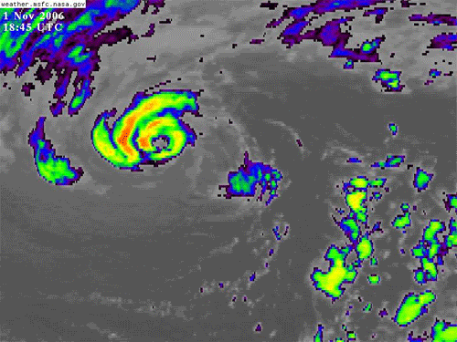
Gosh, it even looks a little like a hurricane, although it is certainly in an unusual place. Miss Madeline | Talk to Madeline 21:57, 1 November 2006 (UTC)
what an unusual invest location. Does the CPHC radar monitor that far north LOL -- グリフオーザー 22:00, 1 November 2006 (UTC)
Wow. Anymore we'll have 91AR-(91 Arctic.Invest). But that is unusually high.MitchazeniaBob Barker's Retiring... 22:17, 1 November 2006 (UTC)
I'm surprised this wasn't noticed earlier, and that we may have Kika anytime with this thing.MitchazeniaBob Barker's Retiring... 22:23, 1 November 2006 (UTC)
Nothing in the TWO. Hurricanehink (talk) 22:46, 1 November 2006 (UTC)
It still looks quite impressive, especially on this (really small) IR loop. This should be classified, but I won't be surprised if it isn't, given that the CPHC tends not to issue advisories on things north of 25-30N. --Coredesat 04:04, 2 November 2006 (UTC)
Very unusual invest, both in latitude and appearance. That sure looks like a mini-hurricane embedded in it (like the unnamed hurricane during the 1991 Hallowe'en Nor'easter). Pobbie Rarr 04:20, 2 November 2006 (UTC)
This should be classified. Looks like a carbon copy of Vince to me. (but of course in a different area). Could you imagine if it was classified and survived to strike Oregon or Washington state as a hurricane? That would be different. →Cyclone1→ 11:01, 2 November 2006 (UTC)
Quikscat, as well as purely satellite derived intensity estimates over the past day, give the system 45 kt sustained winds, so by all rights it should have been named by now. My guess will be the cyclone will be handled as an unnamed TS/ST after the fact. I remember seeing the cyclone phase space diagrams developing this warm seclusion into a moderate warm core cyclone, but I couldn't believe it. The SSTs were colder than any subtropical cyclone I'd seen previously. Its warm core-ness was mentioned in the model diagnostic discussion on Tuesday. =) Thegreatdr 18:26, 2 November 2006 (UTC)
I never thought I'd say this, but it looks like it's heading towards Oregon! →Cyclone1→ 22:46, 2 November 2006 (UTC)
Looks pretty good Good kitty 00:22, 3 November 2006 (UTC)
Wow! It has an eye! It's extremely tiny, but it looks like a strong storm. It looks like it has kept its eye structure for several days. It's in a low pressure centre, and some predict it will make landfall between Oregon and British Columbia. I think it will make landfall in northern Washington, and the much broader area of low pressure could give rain, snow, and storms to the west coast of North America. It already has. Notice that individual parts of this are from the actual weather forecasts. The convection's not looking too good, but it really looks like a storm to watch, particularily with that outstanding eye structure. AstroHurricane001 01:18, 3 November 2006 (UTC)
The storm is now sheared, and it looks to be dissipating. Sorry, but a US landfall as a tropical cyclone seems very unlikely now. Hurricanehink (talk) 02:12, 3 November 2006 (UTC)
If this is later determined to be an unnamed subtropical storm, it would be under CPHC or NHC jurisdiction? CrazyC83 03:42, 3 November 2006 (UTC)
It did travel from CPHC to NHC. I guess either could do it. Thegreatdr 06:06, 4 November 2006 (UTC)
According to the CPHC's website they don't do advisories on subtropical cyclones... – Chacor 06:36, 4 November 2006 (UTC)
As Chacor pointed out in another forum, NASA called the system a subtropical storm. Given that, should we at least mention it in the article? We could mention it's unofficial because the CPHC didn't do advisories on the system and they don't do subtropical storms. Hurricanehink (talk) 17:16, 4 November 2006 (UTC)
NASA is not a RSMC/TCWC, so they can't officially classify it as one. Until there's official word, we're probably going to have to leave it out. Hopefully the NHC will do something about it. --Coredesat 19:08, 4 November 2006 (UTC)
What about the 1992 AHS? We included a storm NASA said was a subtropical storm, but said it was unofficial. I don't see why we can't put that here, and explicitly say it is unofficial. Hurricanehink (talk) 19:18, 4 November 2006 (UTC)
In that case, never mind, it could be worth putting in an "other storms" section, then. --Coredesat 18:12, 7 November 2006 (UTC)
Alright, I added it. Hopefully that works how I did it. Hurricanehink (talk) 00:47, 8 November 2006 (UTC)
Uh, hink wouldn't it be better to call it Storm 91C like NASA does?Mitchazenia 00:57, 8 November 2006 (UTC)
No. That page was wrong, actually. NRL's name for it was 91C Invest. Hurricanehink (talk) 01:05, 8 November 2006 (UTC)
Um, are you freaking kidding me! That picture is amazing. I had no idea this thing even existed. It looks like it could be a subtropical system, but looks can be decieving. The Huroncane of 1996 is a good example. I would very much like to hear what an expert thinks of this system. That part of the world technically shouldn't be having any tropical shenanigans so it would be great if we have some definative answers. (In other words: I really want to know what the hell this thing is.) -- §HurricaneERIC§archive 01:37, 8 November 2006 (UTC)
Here's a discussion at another weather forum. There, some mets thought it was a polar low, while others weren't sure. The thing did have have warm core. I think it has a chance of being upgraded by NHC in post-analysis. Operationally, they don't have the data to upgrade it, but after the fact they have all the time in the world to decide. Hurricanehink (talk) 01:41, 8 November 2006 (UTC)
NHC found that other 2005 subtropical storm in post-analysis, I don't see why CHPC couldn't deem this one a subtropical storm. I'm pretty convinced it's one. Look at these NRL photos: [1], [2]. Look pretty similar don't they? That said, I think it'll be a close call. The "warm core" of this system seems to be just a tiny lukewarm spot [3]. Tough call. I want to say it's subtropical, but I'm really not sure. -- §HurricaneERIC§archive 02:17, 8 November 2006 (UTC)
Very true, though I'm a little worried that the CPHC will classify this. They only issue advisories on tropical cyclones. I can't remember where I read that (I think it was in the forum), but they just don't do it. However, the storm did pass into the NHC's territory, so they might upgrade it themselves. Hurricanehink (talk) 02:20, 8 November 2006 (UTC)
It won't be CPHC. CPHC does not forecast subtropical cyclones. --Coredesat 02:42, 8 November 2006 (UTC)
2005's Subtropical Depression 22 had a very warm core, but I don't know how warm the core has to be before it can be designated as subtropical. Nicole's didn't look a helluva lot warmer [4] but it did look slightly warmer. Another potential nail in the coffin is time. That core was around for roughly 18 hours. That's a pretty short lifespan and I can't speak for CHPC, but I know NHC is usually very timid about upgrading storms that lasted less than 36 hours. With the combination of location, lifespan and a borderline call on the core, I don't think this one will get upgraded. Tropical Depression Sixteen-E last year is a good example of NHC's weight on duration. There is good evidense to suggest the 16E was in fact a tropical storm for a brief time, but because the storm couldn't sustain that strength for longer than 18-24 hours, the storm was not upgraded. The true nature of this storm (with or without designation), however, is very much up in air. -- §HurricaneERIC§archive 02:47, 8 November 2006 (UTC)
Cordesat, I made a query, and it appears you're incorrect concerning ST's and CPHC. I'll look up the NWS guidelines. It would have been odd if two warning centers within the NWS had differing strategies. This means there is a chance of inclusion, after the fact. Thegreatdr 17:15, 8 November 2006 (UTC)
Week 2
19E.Rosa
94E.INVEST
Came off the coast about two days ago. A low formed between two tropical waves, and is moving W. – Chacor 14:06, 7 November 2006 (UTC)
Area of convection near 11N 102W or 350 NM south-southwest of Acapulco, Mexico. Organization is looking better in the convection and a tropical depression could form the next day or two as it heads slowly north-northwest. -- グリフオーザー 18:26, 7 November 2006 (UTC)
Area of convection 430 nm southwest of Acapulco, Mexico. Convection has gotten better this evening. If this trend continues a tropical depression could form on Wednesday as this system slowly moves west-northwest. -- グリフオーザー 04:57, 8 November 2006 (UTC)
Tropical Depression Nineteen-E
TROPICAL DEPRESSION 12.7N 104.5W AT 08/0900Z
ESTIMATED MINIMUM CENTRAL PRESSURE 1007 MB
MAX SUSTAINED WINDS 30 KT WITH GUSTS TO 40 KT. -- グリフオーザー 08:26, 8 November 2006 (UTC)
Should become Rosa at this rate. November isn't usually very active in the Pacific - definitely proof of El Nino. CrazyC83 18:14, 8 November 2006 (UTC)
19E.ROSA (jump)
 NATIONAL HURRICANE CENTER EAST PACIFIC OBJECTIVE AIDS FOR
 TROPICAL STORM       ROSA (EP192006) ON 20061108  1800 UTC
Storm 17: ROSA.Wow what a season.Mitchazenia 19:34, 8 November 2006 (UTC)
Not upgraded at 2100 UTC. --Ajm81 20:59, 8 November 2006 (UTC)
Well, it's the first November tropical cyclone in the eastern north Pacific since 2002. If we get a Rosa it'll be the first EPac tropical storm to form in November since the last Rosa. 1972 got Ruby and Liza in November, the only time there were two November storms of Tropical Storm intensity. Miss Madeline | Talk to Madeline 21:48, 8 November 2006 (UTC)
Interestingly enough, the 1800 UTC models were reissued at 0049 UTC to correct the header to TD 19. The premature upgrade must have been an error. --Coredesat 01:02, 9 November 2006 (UTC)
Upgraded at advisory 6/700 AM PST (091500UTC) to TS Rosa, 17th named storm of year. – Chacor 14:48, 9 November 2006 (UTC)
Now downgraded to a remant low. — Alastor Moody(T + C + U) 02:51, 11 November 2006 (UTC)
20E.NONAME
95E.INVEST
08/0000 UTC 8.4N 111.9W TOO WEAK 95E -- East Pacific Ocean
On FNMOC also. --Ajm81 00:59, 8 November 2006 (UTC)
Gone from NRL. bob rulz 05:29, 9 November 2006 (UTC)
I don't think it was ever on NRL, just FNMOC. (Which it has been on and off of). --Ajm81 15:05, 9 November 2006 (UTC)
NHC still says a depression could form. I wonder why it's not on NRL. 15:35, 9 November 2006 (UTC)
09/1230 UTC 11.6N 113.7W T1.0/1.0 95E -- East Pacific Ocean
Yeah it's still there! -- WmE 16:16, 9 November 2006 (UTC)
Finally on NRL. --Ajm81 17:42, 9 November 2006 (UTC)
A Broad Area of low pressure about 675 nm southwest of southern tip of Baja California Peninsula showing signs of organization and a tropical depression could form during the next couple of days as the system moves slowly north.
TCFA was issued. -- WmE 13:34, 10 November 2006 (UTC)
Could be the twentieth depression of the season. Wow, it also has an active ending. — Alastor Moody(T + C + U) 02:59, 11 November 2006 (UTC)
20E.NONAME
NRL and models initialise TD20. – Chacor 07:02, 11 November 2006 (UTC)
Tropical Depression Twenty-E
Official. Interestingly, the NHC website currently shows "Forecast/Advisory #0". I imagine this will be fixed later. --Coredesat 08:32, 11 November 2006 (UTC)
falled to reach tropical storm status as NHC issues their final advisory on this system -- グリフオーザー 22:18, 11 November 2006 (UTC)
No kidding. It never had much chance. CrazyC83 23:36, 11 November 2006 (UTC)
"96E"
Not on NRL/FNMOC yet but SSD has a fix on it, and the TWOEP mentions it:
09/1800 UTC 7.5N 128.0W T1.0/1.0 96E -- East Pacific Ocean
“
AN AREA OF DISTURBED WEATHER HAS DEVELOPED ABOUT 1700 MILES
SOUTHWEST OF THE SOUTHERN TIP OF BAJA CALIFORNIA. THIS SYSTEM IS
SHOWING SIGNS OF ORGANIZATION...AND SOME SLOW DEVELOPMENT IS
POSSIBLE OVER THE NEXT DAY OR SO.
20th and 21st depression if they form and the first S & T name if they reach storm status since 1992.Mitchazenia-7000+edits 20:23, 9 November 2006 (UTC)
Week 3
21E.Sergio
96E.INVEST
Not the same as above, 10.7N 102.1W --Ajm81 18:16, 12 November 2006 (UTC)
NHC 6am UTC A BROAD LOW PRESSURE AREA LOCATED ABOUT 325 NM SOUTH-SOUTHWEST OF ACAPULCO MEXICO IS MOVING SLOWLY WEST-NORTHWESTWARD. THE ASSOCIATED SHOWER AND THUNDERSTORM ACTIVITY REMAINS DISORGANIZED AND DEVELOPMENT OF THIS SYSTEM IF ANY SHOULD BE SLOW TO OCCUR.
Area of low pressure 350 nm southwest of Acapulco, Mexico has become better organized and has the potential of forming into a tropical depression during the next day or two as the system slowly moves west-northwest.
NRL - tropical depression Twenty-one E -- グリフオーザー 04:18, 14 November 2006 (UTC)
The 21at depression is here! The EPac has now beat the WPac and everyone else in the northern hemisphere! — Alastor Moody(T + C + U) 04:30, 14 November 2006 (UTC)
By the way, that isn't exactly right. The JTWC considered Cimaron to be 23W, including two TDs. Plus, the JMA doesn't number TDs, so in reality the WPac has still been more active than the EPac. But in terms of the two major American basins, then yes, it's been an active EPac season. – Chacor 13:38, 14 November 2006 (UTC)
Tropical Depression Twenty-one-E
NHC confirms. --Ajm81 04:49, 14 November 2006 (UTC)
I wonder if this may become Sergio because 18-E and 20-E were both forecasted to make tropical storm status but failed. If the three depressions didn't fail, we'd have Willa if this depression bcame a tropical storm. — Alastor Moody(T + C + U) 05:15, 14 November 2006 (UTC)
Disco 2:
THE DEPRESSION IS CURRENTLY IN AN AREA OF LIGHT VERTICAL WIND SHEAR
WHICH SHOULD ALLOW STRENGTHENING. LARGE-SCALE MODELS FORECAST A
GENERALLY FAVORABLE SHEAR ENVIRONMENT SOUTH OF 15N NEAR THE
FORECAST TRACK FOR THE NEXT SEVERAL DAYS. THE GFDL MODEL FORECASTS
THE SYSTEM TO BECOME A MAJOR HURRICANE IN 96 HR...WHILE THE SHIPS
MODEL FORECAST IT TO PEAK JUST UNDER HURRICANE STRENGTH IN 60-72
HR. THE NEW INTENSITY FORECAST CALLS FOR MORE STRENGTHENING THAN
PREVIOUSLY...BUT IS STILL BELOW THE SHIPS AND GFDL GUIDANCE. THERE
ARE TWO CONCERNS ABOUT THE INTENSITY FORECAST. FIRST...THE
ENVIRONMENT IS FAVORABLE ENOUGH THAT THERE IS A 40-50 PERCENTCHANCE OF RAPID STRENGTHENING DURING THE NEXT 24 HR ACCORDING TO
THE INDEX ATTACHED TO THE SHIPS MODEL. SECOND...ANY MOTION THAT
DELAYS THE CYCLONE REACHING THE STRONGER SHEAR NORTH OF 15N WOULD
ALLOW IT MORE TIME IN A FAVORABLE ENVIRONMENT. THUS...THE SYSTEMCOULD GET CONSIDERABLY STRONGER THAN FORECAST HERE.
Currently forecast peak is 55kt. -- RattleMan 09:17, 14 November 2006 (UTC)
Tropical Storm Sergio
NATIONAL HURRICANE CENTER EAST PACIFIC OBJECTIVE AIDS FORTROPICAL STORM TWENTY-ONE (EP212006) ON 20061114 1200 UTC
First time Sergio will have been used since 1982. – Chacor 13:05, 14 November 2006 (UTC)
NRL and FNMOC are retaining "21E.INVEST" and "21E.TWENTY-ONE" respectively, but both have it at 35 kt. – Chacor 13:42, 14 November 2006 (UTC)
And confirmed by the NHC. First time two named storms forming in November in EPac since 1961. – Chacor 14:46, 14 November 2006 (UTC)
The East Pacific just keeps crankin' em out. What was that, TD 21E? This name list has never gotten past Tara. But it's already November 14, I would be surprised if EPac isn't done now. There is one last window of opportunity right now with the shear low for a Tara to form but, failing that, I think that the Eastern Pacific is done. It's been a crazy year in the tropics, hasn't it? -- §HurricaneERIC§archive 16:23, 14 November 2006 (UTC)
Now their saying an 80 mph Hurricane Sergio!!!. Wow what a season. Tara would be interesting, but i'm putting doubts on it.Mitchazenia(7300+edits) 17:03, 14 November 2006 (UTC)
I've got this feeling we will see a another Alpha this year to tell you the truth and also in 1992 the list was very nearly exhausted 87.74.19.173 18:22, 14 November 2006 (UTC)
Sergio already? Wow that's quick. They were originally expecting quick dissapation and no effect to land, but with the possibility of a hurricane, I think it might actually affect land if the storm gets steered there. This season has been a lot more intense than last year's Pacific season, and although it hasn't been as active as the big one, this has been a strangely active season, and I'm thinking that a strong El Nino is behind this, or maybe the lack of rain in the Sahara is choking off the Atlantic hurricanes. Let's hope this storm gets steered away from land, so it doesn't break a record for most Mexico landfalls in one season. By the way, do they actually use the Greek Alphebet if the list runs out? AstroHurricane001 18:30, 14 November 2006 (UTC)
Yes, EPAC seasons do use the Greek alphabet, but it is tougher to get to, as they also have names for X, Y, and Z. Hurricanehink (talk) 18:36, 14 November 2006 (UTC)
Now 45 kts according to the newest models. -- WmE 19:53, 14 November 2006 (UTC)
Its not going to break any landfall records either. 2003/05 both saw 8 storms affect Mexico and 1971 saw 9.--Nilfanion (talk) 20:01, 14 November 2006 (UTC)
The El Nino isn't strong at the moment and isn't expected to be strong, as far as I know. bob rulz 21:37, 14 November 2006 (UTC)
Now it seems to be intensifying even more than before. A hurricane is not out of the question. Since it's already November, up to S, and the season still seems to be going, unlike the out-of-energy Atlantic, the season might even make storms in December. Keep in mind that even November storms are quite rare. If this season had any really notable storms, they could be retired, an event about as rare as Atlantic storms not getting retired. AstroHurricane001 22:34, 14 November 2006 (UTC)
Sergio may make some noise (like rushing water) but I still think it'll be the last one of the season. The Pacific this year has been fun to watch. -- §HurricaneERIC§archive 23:07, 14 November 2006 (UTC)
The NRL expects Sergio to peak at 90 mph or at the high level end of Category 1. — Alastor Moody(T + C + U) 02:28, 15 November 2006 (UTC)
GDFL is currently predicting Sergio to reach high-end Category 3. Judging by the satellite imagery, it already looks close to Category 1. Pobbie Rarr 03:08, 15 November 2006 (UTC)
Hurricane Sergio
NRL has it now as a Category 1 with 65 kts. SHIPS isn't very bullish with this system and peaks it at 68kts. We'll see! -- WmE 13:07, 15 November 2006 (UTC)
Confirmed. 11th hurricane of the year (10 EPac-1 CPac).Mitchazenia(7300+edits) 14:52, 15 November 2006 (UTC)
And this blurb doesn't make any sense:
It continued to organise, and was upgraded to a hurricane 24 hours later on November 15, the first hurricane recorded in the Eastern North Pacific in November since Hurricane Octave in 2001, and the first hurricane to form in this basin since Hurricane Rick in 1997.
Is this trying to say that the hurricanes that formed earlier in the year weren't really hurricanes? That's the impression the text is giving. Titoxd(?!?) 16:31, 15 November 2006 (UTC)
Ew messy. The text is trying to say Sergio is the first Pac hurricane since Octave to exist in November and the first since Rick to form in November. However that is horrible phrasing that gives the impression Sergio is the first hurricane in the EPac since 1997 :/--Nilfanion (talk) 17:46, 15 November 2006 (UTC)
If it gets to 970 mbar it'll tie Nora for strongest November hurricane. Hopefully this won't happen. Miss Madeline | Talk to Madeline 17:33, 15 November 2006 (UTC)
Models have it now at 95 knots. SHIPS brings it up to 108 kts (!) and that in mid-november!! -- WmE 18:51, 15 November 2006 (UTC)
(edit conflict) Well, latest SSD classification is 5.0, corresponding to 970 mb... -- RattleMan 18:51, 15 November 2006 (UTC)
Sergio's a very impressive storm, especially this late in the season. Now 95 kts and 965 mbar! -- WmE 20:39, 15 November 2006 (UTC)
Did someone say strongest November EPac hurricane? That's right! —Cuiviénen 21:03, 15 November 2006 (UTC)
Now at 110 mph. Has a equal 50-50 chance of being Category 3 but shear ain't much of a problem here, like what happened to Paul. — Alastor Moody(T + C + U) 05:30, 16 November 2006 (UTC)
according to the NHC's public advisory it is now back down to a cat one storm so ive changed the page to reflect this info87.74.36.63 20:45, 16 November 2006 (UTC)
When you update, be sure to change ALL information. That means you need to update the entire template, the storm history, and the current storm information... -- RattleMan 20:48, 16 November 2006 (UTC)
Week 3
92C.INVEST
New INVEST, near the dateline at 8.6°N 176.1°W. – Chacor 13:32, 14 November 2006 (UTC)
The Central Pacific seems to have had more INVESTs than usual this year, ignoring the high number of TDs and Ioke. —Cuiviénen 19:37, 15 November 2006 (UTC)
NHC bulletin -- グリフオーザー 20:57, 19 November 2006 (UTC) A Low pressure system 760 nm south-southwest of the tip of Baja Californian Peninsula. Activity of showers has changed little in organization however the potential is there for this system to form into a tropical depression within the next day or so as system moves nearly stationary
NHC bulletin -- グリフオーザー 19:44, 20 November 2006 (UTC) A low pressure system about 765 nm south-southwest of the tip of Baja Californian Peninsula continues to be less organized. Upper level winds are prohibiting any further development and the potential for a tropical depression has decreased.
"98E"
SSD has started fixes on a "98E", but there is nothing on NRL or FNMOC.
19/1745 UTC 7.7N 90.0W T1.0/1.0 98E
Doesn't look very good right now. --Coredesat 22:09, 19 November 2006 (UTC)
NHC mentions it now:
SHOWERS AND THUNDERSTORMS...ASSOCIATED WITH A BROAD LOW PRESSURE
AREA...ARE LOCATED AROUND 400 MILES SOUTH OF GUATEMALA. DEVELOPMENT
OF THIS SYSTEM...IF ANY...WILL BE SLOW TO OCCUR AS IT MOVES SLOWLY
WESTWARD.
TROPICAL WEATHER OUTLOOK
NWS CENTRAL PACIFIC HURRICANE CENTER HONOLULU HI
1000 PM HST THU NOV 30 2006
FOR THE CENTRAL NORTH PACIFIC...BETWEEN 140W AND 180
NO TROPICAL CYCLONES ARE EXPECTED THROUGH SATURDAY EVENING.
THE CENTRAL PACIFIC HURRICANE SEASON OFFICIALLY ENDS ON NOVEMBER 30.
THE FINAL TROPICAL WEATHER OUTLOOK OF THE SEASON WILL BE ISSUED AT
10 PM HST NOVEMBER 30. WE WILL RESUME ISSUING OUTLOOKS ON JUNE 1
OF NEXT YEAR.


![[1]](http://www.nrlmry.navy.mil/htdocs_dyn/tc_pages/thumbs/ATL/15L.NICOLE/ssmi/geoir2/20041010.1120.f13.x.goesir2.15LNICOLE.40kts-1002mb-316N-666W.jpg)
![[2]](http://www.nrlmry.navy.mil/tc-bin/tc_display.cgi?BASIN=CPAC&STORM_NAME=91C.INVEST&ACTION=Latest_Photos&ACTIVES=None&MOSAIC_SCALE=20&PHOT=yes&ATCF_BASIN=cp&CGI=TC&AGE=Prev&DISPLAY=Latest&ARCHIVE=all&NAV=tc&YR=06&ATCF_YR=1&YEAR=2006&ATCF_FILE=1/&MO=NOV&CURRENT=20061102.1330.goes11.x.ir1km_bw.91CINVEST.30kts-990mb-421N-1402W.100pc.jpg&ATCF_NAME=cp911&ATCF_DIR=1&STYLE=Frames&TYPE=ssmi&PROD=geoir2&DIR=/TC/tc06/CPAC/91C.INVEST/ssmi/geoir2)
![[3]](http://www.nrlmry.navy.mil/tc-bin/tc_display.cgi?BASIN=CPAC&STORM_NAME=91C.INVEST&ACTION=Latest_Photos&ACTIVES=None&MOSAIC_SCALE=20&PHOT=yes&ATCF_BASIN=cp&CGI=TC&AGE=Prev&ARCHIVE=all&NAV=tc&YR=06&ATCF_YR=1&YEAR=2006&ATCF_FILE=1/&MO=NOV&CURRENT=20061102.1740.f16.x.composite.91CINVEST.35kts-990mb-430N-1374W.92pc.jpg&ATCF_NAME=cp911&ATCF_DIR=1&STYLE=Frames&DISPLAY=Latest&DIR=/TC/tc06/CPAC/91C.INVEST/tc_ssmis/composite&TYPE=tc_ssmis&PROD=composite&SIZE=full)
![[4]](http://www.nrlmry.navy.mil/tcdat/tc04/ATL/15L.NICOLE/ssmi/composite/20041010.1120.f13.x.composite.15LNICOLE.40kts-1002mb-316N-666W.jpg)