
Talk:List of locations in Aksai Chin
| This article is rated List-class on Wikipedia's content assessment scale. It is of interest to the following WikiProjects: | ||||||||||||||||||||||||
| ||||||||||||||||||||||||


Etymology[edit]
Not sure what can be done with this info, but it is something that interests me:
Tibetan:
- 'tang' or 'thang' is likely transcription of Tibetan མཚོ meaning "plains".
- 'tso' is likely transcription from Tibetan མཚོ meaning 'lake'.
- 'ri' is transcription from Tibetan རི meaning 'hill'.
- 'la' is from Tibetan ལ meaning 'mountain pass'.
- 'lungpa' is from Tibetan ལུང་པ.
Turkic/Uyghur:
- 'dawan' also spelled 'davan' or 'daban' is from Uyghur (see etymology of 達坂).
- 'jilga' means brook in numerous Turkic languages (e.g. жылға)
- 'qizil' means red in numerous Turkic languages (e.g. кызыл қызыл)
- 'su' (usually suffix in placenames) means water in numerous Turkic languages (e.g. su (turkish), су (Cyrillic turkic), سۇ)
- 'tagh' means hill in Uygur (i.e. [1])
- 'tash' means stone/rock in Uygur (i.e. تاش)
--Voidvector (talk) 09:28, 26 December 2019 (UTC)
- @Voidvector: Something like what you provided above is needed on the page. If you notice, the maps I provided all have this kind of a map key. A new section could be added above the lists of names- something like this:
Commonly used geographical terminology[edit]
The following is a list of words that appear frequently in English language transcriptions of geographical terminology in the Aksai Chin region:
From Tibetan:
- 'la' is a transcription of the Tibetan term 'ལ' meaning 'mountain pass'.
- 'lungpa' is a transcription of the Tibetan term 'ལུང་པ'.
- 'ri' is a transcription of the Tibetan term 'རི' meaning 'hill'.
- 'tang' or 'thang' is a transcription of the Tibetan term 'མཚོ' meaning 'plains'.
- 'tso' is a transcription of the Tibetan term 'མཚོ' meaning 'lake'.
From Turkic/Uyghur:
- 'dawan' also spelled 'davan' or 'daban' is a transcription of from Uyghur (see etymology of 達坂).[1] and 'La'[1]
- 'jilga' means brook in numerous Turkic languages (e.g. жылға)
- 'qizil' means red in numerous Turkic languages (e.g. кызыл қызыл)
- 'su' (usually suffix in placenames) means water in numerous Turkic languages (e.g. su (turkish), су (Cyrillic turkic), سۇ)
- 'tagh' means hill in Uygur (i.e. [2])
- 'tash' means stone/rock in Uygur (i.e. تاش)
Geographyinitiative (talk) 09:52, 26 December 2019 (UTC)
- Personally, I would don't that as it is difficult to cite, so it becomes a giant block of original research. But I wouldn't mind adding it for each individual article if they exists. --Voidvector (talk) 02:39, 27 December 2019 (UTC)
- @Voidvector: I believe it should be citable to the maps themselves! Here are the terms mentioned in the glossaries on the maps. I want to add them to your lists but I don't know which languages they all originated from.
- Chu - stream
- Davan, Dawan, Dawān, - pass
- La - pass
- Langar - rest house
- Lungpa - valley/stream
- Maidan - plain
- Monte - mount
- Phu - valley
- Ri - mountain
- Rong - gorge
- Su - stream
- Tagh, Tāgh - mountain
- Tang, Tāng Thang - plain
- Tso - lake
- Valle - valley
Geographyinitiative (talk) 08:03, 27 December 2019 (UTC)
References
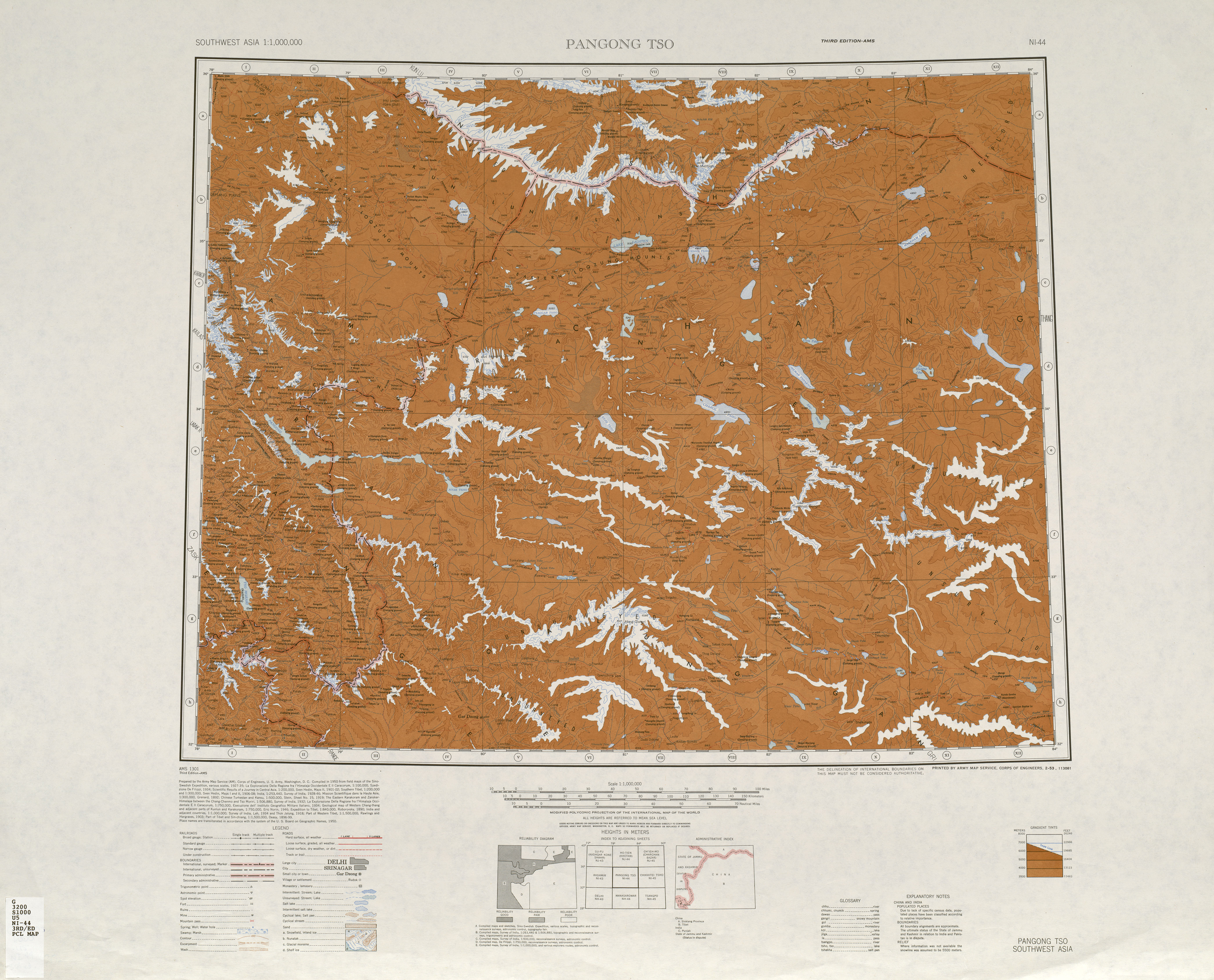
- ^ a b "NI 44 Pangong Tso". Washington, D. C.: Army Map Service. 1950 – via Perry–Castañeda Library Map Collection.
Haji Langar (Qara Qāsh){...}Khitai Dawān{...}Aq-qum Dawān{...}Mapo-thang La{...}Mangrik Basin{...}Tso Thang{...}Konka La{...}Lanak La{...}Domjar La (Kone La){...}dawan-----pass{...}la----pass
Ambiguous locations - Tielongtan & Quanshuigou[edit]
As mentioned earlier, I couldn't find much info about Tielongtan (铁隆滩), I also encounter similar issue with Quanshuigou (泉水沟). Both are locations along the highway in Aksai Chin and mentioned in geology papers and on some maps. But some report conflicting locations. Beyond that, I couldn't find concrete modern info about those 2 locations:
- no trace on satellite maps
- nothing of note along the highway by dashboard cameras
- nothing written about them beyond geology stuff
According to OpenStreetMap:
- Quanshuigou is a truck stop - https://www.openstreetmap.org/node/6321308094
- Tielongtan is a highway checkpoint - https://www.openstreetmap.org/node/4120488300
According to Baidu wiki
- Quanshuigou (at km 540)
- Tielongtan (between km 580 and km 635) is a road fork between the fork to Aksai Chin Lake and Tibet-Xinjaing border (based on other maps this would be the road fork to Wenquan)
This Chinese map seems to agree with Baidu wiki.
Other Chinese maps:
- http://picuser.city8.com/news/image/20141020/%BA%CD%CC%EF%B5%D8%C7%F8%B5%D8%CD%BC%B8%DF%C7%E5%B0%E6.jpg
- http://www.onegreen.net/maps/Upload_maps/201711/2017112114555797.jpg
- http://www.guang.net/m/a/hetianxian.jpg
- http://image.hnol.net/c/2017-04/21/07/201704210728023451-4718722.jpg
You can find those maps on Google images by searching for "和田县 地图" (Hetian county map).
My theory is that those places might only exists temporarily as camps for geologist, police, construction workers. --Voidvector (talk) 05:31, 28 December 2019 (UTC)
New Category[edit]
@Voidvector: I would first like to say that I have enjoyed working on the Aksai Chin minor geography stuff with you. Although it is a sensitive topic and this new page is only in its infancy, I think that there is some base level of "brute facts", like these lists of locations, that Wikipedia should be a repository of. Now, because of this work, anybody who is researching Aksai Chin history will be able to use a search engine to find these locations and an old map that shows where they are. I feel that the work here has begun to illuminate a small but important corner of our knowledge of the world and that that work is inherently a good thing.
Good idea to make the page!
Down to business: I was thinking- should we create a new category for minor locations and etc articles that have to do with Aksai Chin? Something like "Category:Aksai Chin"? We already have like nine minor locations plus the main page itself. I think it could be useful to readers but idk. Happy New Year to you! Geographyinitiative (talk) 16:47, 31 December 2019 (UTC)
- Indeed, thank you both for creating this page. It is very useful that we have a searchable list with map locations. Happy New Year!
- Pinging The Discoverer, who might have an interest in this page as well. -- Kautilya3 (talk) 17:50, 31 December 2019 (UTC)
- I know this is not my style of doing research/writing articles, but I have to say Geographyinitiative's approach has been very fruitful in allowing me to easily cross reference literary sources with geographic locations, and use nearby locations to find more references. I would totally support a category for this. Happy New Year to both of you as well!! --Voidvector (talk) 02:55, 1 January 2020 (UTC)
- Thanks for the ping, you all are doing a great job, nothing for me to add at the moment. :) The Discoverer (talk) 18:01, 6 January 2020 (UTC)
Smaller mines[edit]
There are numerous small scale mines (prospecting mines?) in the region. They are mentioned in China Geological Survey presentations and in academic papers.
- http://www.cgs.gov.cn/ddztt/kydh/2017kydh/xjz/201709/P020170921516042844582.pdf (p27)
- http://www.wutanyuhuatan.com/article/2017/1000-8918/1000-8918-41-3-410.html (figure 1, figure 9)
- http://xbdz.cnjournals.cn/ch/reader/create_pdf.aspx?file_no=20130111 (figure 3)
However, the maps in those are either not detailed enough or are of rock strata, so it is quite difficult identifying their exact locations. --Voidvector (talk) 19:10, 25 January 2020 (UTC)
List of location names in Ngari Prefecture including Chinese and Tibetan[edit]
[3] Geographyinitiative (talk) 04:56, 26 January 2020 (UTC)
- Nice, I have been using this. --Voidvector (talk) 05:20, 26 January 2020 (UTC)
- Geographyinitiative, shouldn't we list places in Tibetan Aksai Chin as well?
- Now there is a road through there. -- Kautilya3 (talk) 21:26, 14 September 2020 (UTC)
- @Kautilya3 and Voidvector: When it was suggested that a page like this might be a good idea, I just wanted to document the names of all the campsites, mountains, mountain passes and streams I was seeing on some old maps and provide a kind of index of these with coordinates. Aksai Chin is just a small part of a gigantic wilderness zone between Xinjiang and the more densely inhabited parts of southern Tibet (see the wilderness of Gerze County). Before I made this page, I had already started experimenting with adding campsite names to pages like Qira County.
Some of the minor locations in Aksai Chin turned out to actually have Wikipedia pages themselves. I would say that names of roads might qualify to be added here too, especially if there aren't that many roads in Aksai Chin. If there are areas with lots of minor roads in a small area, that might indicate that we need a page for that location on Wikipedia.
"Tibetan Aksai Chin" has a big section in the south, but there are also at least two small "discontinuous" parts of "Tibetan Aksai Chin" in the north (see Google Maps). We have included a lot of the minor geography from the big part of "Tibetan Aksai Chin" in the south. The smaller parts in the northeast are not as fully documented.
The small "Tibetan Aksai Chin" area near Surigh Yilganing has some unlabeled mountains and streams in this map: [4]. (Note that this map may have (in places) assumed that the Xinjiang-Tibet border was the same as India's Aksai Chin claim line, which may not be correct according to Google Maps.)
The close-up AMS map of the area right around Aksai Chin Lake seems not to be available online, and hence minor geography in the northern-most "Tibetan Aksai Chin" slice is not documented yet (as far as I know). Geographyinitiative (talk) 06:42, 15 September 2020 (UTC) (modified) - Also, the red line representing Kongka La Highway in the map link above did not seem to enter Aksai Chin although it is close to Aksai Chin. Geographyinitiative (talk) 06:44, 15 September 2020 (UTC)
- I think you are talking about the "political Aksai Chin", which is bounded by the Johnson Line (boundary), drawn somewhat arbitrarily for political purposes. The geographical Aksai Chin is bounded on the south by the Chang Chenmo Valley, whose continuation into Tibet is where the new Chinese road runs. (Somebody on OpenStreetMap labelled it "Kongka La Highway" but it makes sense as a continuation of the Kongka La Highway (S519) that runs between Kongka La and G219.)
- The old British Raj era maps label all this area as Aksai Chin. On Google Maps, you can see that the Bangda Lake/Yeshil Kul is right in the middle of the continued "Chang Chenmo Valley". Between the Bangda Lake and Lake Lighten, there is the continuation of the Lak Tsung range, which is making a giant arc. Hedin apparently did not recognize this fact, and put Aksai Chin to the west of Lake Lighten.
- So, I suggest adding all the locations till Bangda Lake on this page. Now that a road is going to pass here, we will probably hear more about it in future. -- Kautilya3 (talk) 12:01, 15 September 2020 (UTC)
- @Kautilya3 and Voidvector: When it was suggested that a page like this might be a good idea, I just wanted to document the names of all the campsites, mountains, mountain passes and streams I was seeing on some old maps and provide a kind of index of these with coordinates. Aksai Chin is just a small part of a gigantic wilderness zone between Xinjiang and the more densely inhabited parts of southern Tibet (see the wilderness of Gerze County). Before I made this page, I had already started experimenting with adding campsite names to pages like Qira County.
![[4]](https://commons.wikimedia.org/wiki/File:NI-44-06_Lungmu_Co,_China.jpg)
[Aurel Stein's] first letter to Publius was written on 16 August 1908, Camp Saghiz-kal, Aksai-chin plateau.[1]
Where is this place? -- Kautilya3 (talk) 12:58, 9 October 2020 (UTC)
- Found it. It is apparently now called Aqikekule ([https://www.openstreetmap.org/#map=10/35.7206/81.4691&layers=C OpenStreetMap). It is in the middle of Kuen-Lun range. No idea why this area was called "Aksai Chin". -- Kautilya3 (talk) 15:45, 9 October 2020 (UTC)
References
- ^ Mirsky, Jeannette (1998), Sir Aurel Stein: Archaeological Explorer, University of Chicago Press, p. 309, ISBN 978-0-226-53177-9
Mountain passes on Highway 219[edit]
The China National Highway 219 page has a song about various mountain passes on it. The first pass seems to be in Xinjiang and the last pass is in Tibet, so the middle two may be in Aksai Chin. Geographyinitiative (talk) 07:10, 3 April 2020 (UTC)
- Interesting. I just marked Jieshan Pass on OSM today [5], just outside the Indian claim line.
- Mazar is a place 25 miles west of Xaidulla, where G219 goes up the mountains. The pass was marked by Voidvector [6].
- Heiqia Daban was misspelt, but wasn't too hard to find [7].
- I don't know where Kudi Daban is.
- If they had to list a pass in Aksai Chin, they would have to say, "you didn't even know you passed it"! -- Kautilya3 (talk) 21:24, 14 September 2020 (UTC)
- Kudi Daban is further north of "Heiqia Daban", no article. Heqia Daban is Kirgizjangal Pass. --Voidvector (talk) 08:24, 24 October 2020 (UTC)
Numkum?[edit]
Part of the Numkum (sp?) stream seems to be on the edge of the Indian claim in this map: [8] But I can't say for sure either on the spelling or whether or not it actually enters the Indian claim area. Southern rim of Bangong Co/Pangong Tso. Geographyinitiative (talk) 06:03, 20 May 2020 (UTC)
Mine/deposit locations[edit]
This geology paper (doi:10.18654/1000-0569/2021.12.03) has maps (especially figure 11) marking a bunch of more mine or deposit locations with names. --Voidvector (talk) 10:36, 10 March 2022 (UTC)
- List-Class geography articles
- Low-importance geography articles
- WikiProject Geography articles
- List-Class China-related articles
- Mid-importance China-related articles
- List-Class China-related articles of Mid-importance
- WikiProject China articles
- List-Class India articles
- Mid-importance India articles
- List-Class India articles of Mid-importance
- List-Class Jammu and Kashmir articles
- Mid-importance Jammu and Kashmir articles
- List-Class Jammu and Kashmir articles of Mid-importance
- WikiProject Jammu and Kashmir articles
- WikiProject India articles