
Quickville, Kansas
Quickville, Kansas | |
|---|---|
 | |
 Quickville  Quickville | |
| Coordinates: 39°31′41.4″N 101°16′49.3″W / 39.528167°N 101.280361°W | |
| Country | United States |
| State | Kansas |
| County | Thomas |
| Elevation | 3,307 ft (1,008 m) |
| Population | |
| • Total | 0 |
| Time zone | UTC-6 (CST) |
| • Summer (DST) | UTC-5 (CDT) |
| Area code | 785 |
| GNIS ID | 482662 [1] |
Quickville is a ghost town in Thomas County, Kansas, United States. It is farm ground with no remaining structures.
History[edit]
Quickville was platted on June 27, 1887, by the Thomas County Land and Townsite Co.[2][3]
It was issued a post office in 1880. The post office was discontinued in 1909.[4]
References[edit]
- ^ "Quickville, Kansas", Geographic Names Information System, United States Geological Survey, United States Department of the Interior
- ^ The National Gazetteer of the United States of America--Kansas, 1984. U.S. Government Printing Office. 1985.
- ^ "Thomas County Schools". Kansas Historical Society. Retrieved 2022-03-14.
- ^ "Kansas Post Offices, 1828-1961". Kansas Historical Society. Retrieved 2018-01-05.
Further reading[edit]
External links[edit]
Municipalities and communities of Thomas County, Kansas, United States | ||
|---|---|---|
| Cities | 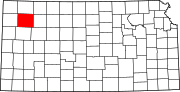 | |
| Unincorporated communities | ||
| Ghost towns | ||
| Townships |
| |
| Footnotes | †This community is designated a Census-Designated Place (CDP) by the United States Census Bureau. ‡This community also has portions in an adjacent county or counties. | |
This article about a location in Thomas County, Kansas is a stub. You can help Wikipedia by expanding it. |