Portal:Poland/Selected article/38
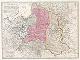
The Second Partition of Poland in 1793 was the second of three partial annexations that ended the existence of the Polish–Lithuanian Commonwealth by the end of the 18th century. It was a result of the Polish–Russian War of 1792, in which the Targowica Confederation overturned the progressive Constitution of 1791. The Russian Empire took 250,000 km2 (97,000 sq mi) of the Commonwealth's eastern territories, now belonging to Belarus and Ukraine, while the Kingdom of Prussia gained Danzig (Gdańsk) and 58,000 km2 (22,000 sq mi) of western Poland, which it renamed South Prussia. Poland was left as a rump state of 215,000 km2 (83,000 sq mi). Under Russian pressure, the partition was ratified by Poland at the Grodno Sejm in a short-lived attempt to prevent a complete annexation of Poland, which eventually did happen in the Third Partition in 1795. (Full article...)

