
Pont-l'Abbé
Pont-l'Abbé
Pont-'n-Abad | |
|---|---|
 The harbour of Pont-l'Abbé | |
 Flag  Coat of arms | |
| Motto: Heb Ken | |
Location of Pont-l'Abbé  | |
 Pont-l'Abbé  Pont-l'Abbé | |
| Coordinates: 47°52′05″N 4°13′19″W / 47.8681°N 4.2219°W | |
| Country | France |
| Region | Brittany |
| Department | Finistère |
| Arrondissement | Quimper |
| Canton | Pont-l'Abbé |
| Intercommunality | Pays Bigouden Sud |
| Government | |
| • Mayor (2020–2026) | Stéphane Le Doaré[1] |
| Area 1 | 18.21 km2 (7.03 sq mi) |
| Population (2021)[2] | 8,395 |
| • Density | 460/km2 (1,200/sq mi) |
| Time zone | UTC+01:00 (CET) |
| • Summer (DST) | UTC+02:00 (CEST) |
| INSEE/Postal code | 29220 /29120 |
| Elevation | 0–37 m (0–121 ft) |
| 1 French Land Register data, which excludes lakes, ponds, glaciers > 1 km2 (0.386 sq mi or 247 acres) and river estuaries. | |
Pont-l'Abbé (French pronunciation: [pɔ̃ labe]; Breton: Pont-'n-Abad, "Abbot's bridge") is a commune in the Finistère department of Brittany in north-western France.
The self-styled capital of Pays Bigouden (roughly the region between the river Odet and the Bay of Audierne), Pont-l'Abbé was founded in the 14th century by a monk of Loctudy who built the first bridge across the river estuary, hence the name. The same monk also built the first castle.
Geography[edit]
Climate[edit]
Pont-l'Abbé has a oceanic climate (Köppen climate classification Cfb). The average annual temperature in Pont-l'Abbé is 12.8 °C (55.0 °F). The average annual rainfall is 993.3 mm (39.11 in) with November as the wettest month. The temperatures are highest on average in August, at around 18.7 °C (65.7 °F), and lowest in January, at around 7.5 °C (45.5 °F). The highest temperature ever recorded in Pont-l'Abbé was 37.1 °C (98.8 °F) on 16 July 2006; the coldest temperature ever recorded was −10.8 °C (12.6 °F) on 2 January 1997.
| Climate data for Pont-l'Abbé (1981–2010 averages, extremes 1994−2020) | |||||||||||||
|---|---|---|---|---|---|---|---|---|---|---|---|---|---|
| Month | Jan | Feb | Mar | Apr | May | Jun | Jul | Aug | Sep | Oct | Nov | Dec | Year |
| Record high °C (°F) | 16.7 (62.1) |
18.6 (65.5) |
22.5 (72.5) |
28.0 (82.4) |
31.4 (88.5) |
35.4 (95.7) |
37.1 (98.8) |
36.6 (97.9) |
32.3 (90.1) |
28.1 (82.6) |
21.5 (70.7) |
19.1 (66.4) |
37.1 (98.8) |
| Mean daily maximum °C (°F) | 10.9 (51.6) |
11.8 (53.2) |
13.8 (56.8) |
16.1 (61.0) |
19.3 (66.7) |
22.2 (72.0) |
23.4 (74.1) |
24.1 (75.4) |
21.9 (71.4) |
18.1 (64.6) |
14.2 (57.6) |
11.2 (52.2) |
17.3 (63.1) |
| Daily mean °C (°F) | 7.5 (45.5) |
8.0 (46.4) |
9.4 (48.9) |
11.2 (52.2) |
14.3 (57.7) |
17.0 (62.6) |
18.5 (65.3) |
18.7 (65.7) |
16.6 (61.9) |
14.0 (57.2) |
10.5 (50.9) |
7.8 (46.0) |
12.8 (55.0) |
| Mean daily minimum °C (°F) | 4.1 (39.4) |
4.2 (39.6) |
5.0 (41.0) |
6.2 (43.2) |
9.4 (48.9) |
11.8 (53.2) |
13.5 (56.3) |
13.3 (55.9) |
11.3 (52.3) |
10.0 (50.0) |
6.8 (44.2) |
4.4 (39.9) |
8.4 (47.1) |
| Record low °C (°F) | −10.8 (12.6) |
−6.6 (20.1) |
−7.0 (19.4) |
−1.6 (29.1) |
0.3 (32.5) |
4.1 (39.4) |
6.5 (43.7) |
6.1 (43.0) |
3.2 (37.8) |
−1.6 (29.1) |
−3.7 (25.3) |
−7.7 (18.1) |
−10.8 (12.6) |
| Average precipitation mm (inches) | 114.8 (4.52) |
92.7 (3.65) |
72.4 (2.85) |
78.1 (3.07) |
69.3 (2.73) |
43.3 (1.70) |
53.1 (2.09) |
59.1 (2.33) |
62.3 (2.45) |
103.4 (4.07) |
126.2 (4.97) |
118.6 (4.67) |
993.3 (39.11) |
| Average precipitation days (≥ 1.0 mm) | 14.8 | 12.1 | 11.9 | 11.2 | 9.9 | 6.8 | 9.4 | 8.2 | 8.7 | 14.0 | 16.4 | 15.5 | 138.9 |
| Source: Meteociel[3] | |||||||||||||
Population[edit]
Inhabitants of Pont-l'Abbé are called in French Pont-l'Abbistes.
|
|
| |||||||||||||||||||||||||||||||||||||||||||||||||||||||||||||||||||||||||||||||||||||||||||||||||||||||||||||||||||||
| Source: EHESS[4] and INSEE (1968-2017)[5] | |||||||||||||||||||||||||||||||||||||||||||||||||||||||||||||||||||||||||||||||||||||||||||||||||||||||||||||||||||||||
Breton language[edit]
The municipality launched a linguistic plan concerning the Breton language through Ya d'ar brezhoneg on 2 February 2008.
In 2008, 5.08% of primary-school children attended bilingual schools.[6]
The Fête des Brodeuses (Embroideress' Festival) in July is one of Brittany's major traditional gatherings, and includes a Breton Mass at the Notre-Dame des Carmes church.
Sights[edit]
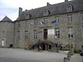
- Pont-l'Abbé castle dates from the 14th to the 18th centuries. The "wedding" room is decorated with Mathurin Méheut pieces of art (Sainte-Marine port), Henri Sollier and Jacques Godin. Once bigger, the castle lost its ramparts during the 19th century. Today only the bridge, the keep, and a very small part of the ramparts, in the garden nearby, can be seen. The structure now serves as the city hall, housing also the Bigouden Museum, offering a fine collection of costumes and Bigouden head-dresses,
- Church of Notre-Dame des Carmes dates from 1383-1420 in the Gothic style, with many old statues and a very fine rose window over the high altar that is considered the loveliest in Brittany.
- Church of Lambour (13th-16th century) had its roof removed in 1675 in the reign of Louis XIV in reprisal against the "Red Bonnets" uprising.
- The Monument aux Bigoudens is a masterpiece in granite by François Bazin (1931) and shows a group of four Bigoudène women and a child in traditional costume from the beginning of the 20th century, all of them thinking of a son, a father, a husband or a grandson battling the elements on the high seas.
- The Manoir de Kernuz was restored c. 1850 by the historian of Brittany, Armand du Chatellier.
- The Manoir de Kerazan located between Pont-l'Abbé and Loktudi delivers a fine art of Architecture.
- The Chapel of Treminoù (the missings in Breton) on the road to St-Jean-Trolimon, celebrates the memory of the Breton insurgents slaughtered by the French army of Louis XIV. In particular, A gathering in the last week of September and a funfair festival in the City recalls this period of Brittany's history.
- A few Menhirs still island upright around the city.
- Down to the river by the sea, lies a ria, having given its name to Loktudi (Loch Tudi, the lagoon of Saint Tudi) and Isle Tudi, which shares some beautiful sights.
-
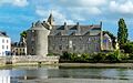
 Present view of the Castle's keep, south view.
 -
 the Castle's keep, north view.
 -
 the Castle's keep, from Rue Kereon, 1921.


International relations[edit]
Pont-l'Abbé is twinned with:
Personalities[edit]
- Vincent Riou, a yacht race Sailor who distinguished himself at Vendée Globe Challenge 2004-2005 (1st) and 2008-2009 (3rd) with act of bravery, saving Jean Le Cam's life, who was sinking near of Cape Horn.
- Jérôme Kerviel, the trader formerly with Société Générale in Paris that was linked with losses of approximately €4.9 billion (US$7.16 billion) stemming from fraudulent equity index futures trading, grew up in Pont-l'Abbé.
See also[edit]
References[edit]
- ^ "Répertoire national des élus: les maires". data.gouv.fr, Plateforme ouverte des données publiques françaises (in French). 9 August 2021.
- ^ "Populations légales 2021". The National Institute of Statistics and Economic Studies. 28 December 2023.
- ^ "Normales et records pour Pont-l'Abbe (29)". Meteociel. Retrieved 10 June 2022.
- ^ Des villages de Cassini aux communes d'aujourd'hui: Commune data sheet Pont-l'Abbé, EHESS (in French).
- ^ Population en historique depuis 1968, INSEE
- ^ (in French) Ofis ar Brezhoneg: Enseignement bilingue
External links[edit]
- Official website (in French)
- Official Pont-l'Abbé Tourism site
- Bigouden Museum of Pont-l'Abbé (in French)
- Ar Triskell, Cultures' House of Pont-l'Abbé (in French)
- Base Mérimée: Search for heritage in the commune, Ministère français de la Culture. (in French)
- Mayors of Finistère Association (in French)
| International | |
|---|---|
| National | |
| Geographic | |